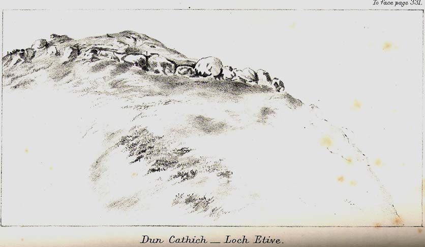
Dun Chathach, Connel, Argyll

Hillfort: OS Grid Reference – NM 9674 3401

Also known as:

  1. Canmore ID 23261
  2. Dun Cathich

Getting Here

Dun Chathach (drawn by Miss J. Knox Smith 1885)

Go up from Oban on the A85, past Connel and towards Taynuilt, keeping your eye out for where the train-line crosses the road. Just before this is a small road on your left leading down to the sea, with the train line running parallel all the way down. Go right to the end and then look up to the rocky rise a coupla hundred yards on where the train line runs out of view round the coastal edge. That’s it!

Archaeology & History

When Scottish writer and historian R. Angus Smith (1885) first saw this, the close arrangement and size of the stones that make up the edges of this dun made him think this was actually a stone circle up here.  Sadly it wasn’t to be.  Following an examination of the site in 1969 by members of the Scottish Royal Commission (Argyll – Volume 2, 1975), they described Dun Chathach as,

“circular in plan…measuring 18.3 metres in diameter externally. The wall, which has been about 3.4 metres in average thickness, is now reduced to a low grass-grown stony bank, but considerable stretches of the outer face are still visible in situ. Many of the facing stones, which lie as much as 1.6 metres below the level of the summit, are of massive proportions, the largest measuring 1.4 metres by 1.3 metres and 1 metre high. It is uncertain which of the three gaps now visible in the wall indicates the site of the original entrance.”

Folklore

Legend has it that this was a hill of battles.  It was also said by R. Angus Smith (1885) to “have been used as one of a chain of beacons,” with the next fire on being lit upon a small hill nearer Connel called Tom na h-aire, ‘the mound of watching.’

References:

  1. Royal Commission on the Ancient & Historical Monuments, Scotland, Argyll- volume 2, HMSO: 1974.
  2. Smith, R. Angus, Loch Etive and the Sons of Uisnach, Alexander Gardner: London & Paisley 1885.

© Paul Bennett, The Northern Antiquarian
Loch Seil, Kilninver, Argyll

Crannog (submerged):  OS Grid Reference – NM 80390 20292

Also Known as:

  1. Canmore ID 22994

Getting Here

A beautiful place found along the roadside towards Seil Island, on the B844 a few miles south of Oban.  When you get near the south end of the loch right by the road, have a gander!  If the waters are low you can sometimes see the ghostly island appear above the waves…

Archaeology & History

You’re lucky to see owt here – the isle has all but submerged.  This old artificial island could once be clearly seen less than 400 yards south of Duachy farmhouse, near the southwestern edge of the loch.  It measured roughly 10 yards by 8 yards, was built of stones, seemingly “with a boat-slip on the west side and a ‘square place’ on the east as if for a landing stage.”  All trace of the causeway linking it to the shore has apparently vanished.  But if you do stop here, check out the Duachy Standing Stones on the hillside behind you!

References:

  1. Royal Commission on the Ancient & Historical Monuments of Scotland, Argyll – volume 2: Lorn, HMSO: Edinburgh 1974.#

© Paul Bennett, The Northern Antiquarian


Eilean Musdile, Lismore, Argyll

Standing Stone (destroyed):  OS Grid Reference – NM 778 351

Also Known as:

  1. Canmore ID 22659

Archaeology & History

Once to be seen on the highest point of the island, this impressive 9-foot tall standing stone is thought to have been removed during construction of the old lighthouse around 1833.  First described by a traveller here in 1784, it was mentioned just once again during survey work in 1829. The monolith appears to have recorded the midwinter sunset.

References:

  1. Royal Commission on the Ancient & Historical Monuments of Scotland, Argyll – volume 2: Lorn, HMSO: Edinburgh 1975.

© Paul Bennett, The Northern Antiquarian


Dalineun Isle, Loch Nell, Argyll

Crannog:  OS Grid Reference – NM 88350 26628

Getting Here

Take the A816 south from Oban and after 2 miles at the hamlet of Kilmore, turn left.  Follow the road for nearly a mile and as the loch appears ahead of you, stop!  The small island crannog is close by the bottom of the loch in front of you.

Archaeology & History

Curiously omitted from the Scottish Royal Commission inventory for Lorn (1974), when R. Angus Smith and his friends explored this artificial island in the 1860s and ’70s, he told:

“it is nearly round, not much larger than a good-sized cottage. It is surrounded by stones large enough to be difficult to lift, and in some places showing themselves to have been put together by art. It would appear as if there had been a pretty firm wall all round – very firm it could not be without mortar or heavier stones. Three or four feet within the range of stones is a raised turf-mound, as if this had been the wall of a house; the centre of the space was rather higher than the rest, and there we expected a fire-place to be found.”

Once they’d got onto the old crannog, Smith and his associates started digging, saying,

“by digging about three feet and a half, the ashes of peat were obtained, bones, charcoal and nuts. A very small hole was made, as we had not then received liberty to dig. We were satisfied that this had been a lake-dwelling, and that it had been defended by a wall. Advantage seems to have been taken of a shallow place, and stones must have been carried to it. It may turn out that there is a wooden foundation. It is not easy to see by what means the covering of earth now over the floor was so much raised. The water of the lake forms little or no deposit in summer; art rather than natural circumstances may have raised the soil. The bones here were split, as at the lake-dwelling in the moss.”

References:

  1. Smith, R. Angus, Loch Etive and the Sons of Uisneach, Alexander Gardner: London 1885.

© Paul Bennett, The Northern Antiquarian


Connel, Oban, Argyll

Standing Stone (destroyed):  OS Grid Reference – NM 9169 3408

Also Known as:

  1. Canmore ID 23281

Archaeology & History

Connel stone on 1871 map

The Royal Commission for Historic Scotland (1974) recorded this “stone that formerly stood within the area now occupied by Connel Station,” which was thought to have been destroyed shortly before construction of the said building.  Thankfully the Ordnance Survey lads recorded its position on their cartographic ventures here in 1871.  Mr R.A. Smith (1874) also mentioned the site, albeit briefly, in his fine series of essays on the antiquities of Loch Etive, telling us:

“Above Connell Ferry we come to a small brook called Lusragan, and a few houses with a mill called Clachaleven. To the east, in a  field above the road, is a large standing stone, and around it marks where others, well remembered, lately stood.”

But sadly it seems, these have all gone.

References:

  1. Royal Commission for Ancient & Historical Monuments, Scotland, Argyll – volume 2: Lorn, HMSO: Edinburgh 1974.
  2. Smith, R. Angus, “Descriptive List of Antiquities near Loch Etive, part 3,” in PSAS, 10, 1874.

© Paul Bennett, The Northern Antiquarian


Cairnbane, Portnacroish, Argyll

Chambered Cairn (destroyed):  OS Grid Reference – NM 925 473

Also Known as:

  1. Canmore ID 23301
  2. Karn Vain

Getting Here

Sadly this site can no longer be seen, but it was evidently something worth seeing in its day.  Twas found “on the north side of Loch Laich, opposite Castle Stalker.”

Archaeology & History

In 1758 W. Burrell wrote about “a very large circular heap of stones, called Cairnbane, in which are said to be several subterraneous apartments, the passages leading to them, supported by large beams of timber in some places, in others by large stones, the entrance is now closed with a stone.” But in 1760 Richard Pococke reported that he could enter the cairn, saying that,

“on the west side of it a little way up is a very difficult entrance which leads to a cell about two yards long and one and a half broad, a this by a sort of door place to another about the same dimensions. I observed in some parts the stones on the side are laid flat, in others edge way, and a little sloping, and large stones are laid across on the top; To the north of it is a low heap of stones, in which three mouths of entrances are very visible, and there seemed to be two more; …the large one is twelve yards long at the top and about a yard broad: It is not improbable that these cells were built all round and several stories of them one over another.”

Explorations here by A.S. Henshall and the Royal Commission for Historic Scotland were unable to find the site and it has been deemed missing or destroyed.  I have yet to seek out any folklore relating to this lost site, but would be very surprised if there wasn’t something loitering in some of the old tongues and tomes!

References:

  1. Royal Commission on the Ancient & Historical Monuments of Scotland, Argyll – volume 2: Lorn, HMSO: Edinburgh 1975.

© Paul Bennett, The Northern Antiquarian


Taynuilt, Lorn, Argyll

Standing Stone:  OS Grid Reference – NN 0120 3115

Also Known as:

  1. Canmore ID 23497

Archaeology & History

Nearly twenty years have passed by since I last saw this rather small standing stone – ‘small’ for Argyll that is!  It’s near the corner of a field half-a-mile east of Taynuilt village, about 300 yards off the main Oban road. The Scottish Royal Commission (1974) chaps describe it quire accurately, telling it to be,

“a granite boulder, roughly triangular in shape at the base, and measuring 0.75 metre by 0.60 metre by 0.55 metre at ground-level. It now stands to a height of 1.2 metres (nearly four-feet tall in normal language! – Ed), but pieces have been split off in comparatively recent times and it may originally have been taller.”

It’s about time I got my arse back up ambling and exploring around this part of Scotland.  Tis a gorgeous part of the world…

References:

  1. Royal Commission on the Ancient & Historical Monuments, Scotland, Argyll – volume 2, HMSO: Edinburgh 1974.

© Paul Bennett, The Northern Antiquarian