Located in the copse known as Godwell’s Grove on the western boundary of Arkesden, there are good grounds for thinking this was a sacred well: not necessarily relating to the christian God, but what A.H. Smith (1956) described simply as, from the old English, “a (heathen) god.” Another site of the same name is found in Wiltshire. In the local survey by Parish (2010), he told that “its name suggests it is a holy well.”
In Reaney’s (1976) survey on English place-names, he looks at a number of places where the element “god” is found and explores the notion of them recording a personal name, Gode. This is evident of course, but he stated that,
“it would indeed be a remarkable coincidence if all these names…were to contain the personal-name Gode, a short form of Godric, Godwine, etc. It in inconceivable that the reference should be to the christian deity… All are situated in areas of early settlement where heathen place-names might be expected and may well contain OE god, ‘a god’.”
There is no longer any trace of the well.
References:
Parish, R.B., Holy Wells and Healing Springs of Essex, Pixyled Press: Nottingham 2010.
Reaney, P.H., The Place-Names of Essex, Cambridge University Press 1935.
Reaney, P.H., The Origin of English Place-Names, RKP: London 1976.
Smith, A.H., English Place-Name Elements – volume 1, Cambridge University Press 1956.
Robin Hood wells are numerous in Yorkshire and Derbyshire, but finding them in this neck o’ the woods is unusual (a Robin Hood’s Farm can be found nearly 14 miles south). The waters here would have had obvious importance for local peasant folk in bygone centuries, perhaps with scatterings of Beltane and Midsummer rites hereby; but it seems that records are silent on such matters. The only reference I can find of this place is in Bracken’s (1860) fascinating work on Sutton Coldfield, where he told that,
“At the extremity of the parish, near Pype, a little field is still called the Bowbearer’s Croft. Tradition says two officers of the chase, bowbearers, had a lodge there; and that their duty was to guide the travellers across the wild country. A very old cottage, that had been well built, was removed from the croft in 1828. In that neighbourhood was a fountain, called Robin Hood’s well, now enclosed within the grounds of Penns, where the natural beauties of the situation have been judiciously displayed and improved by the taste of the late proprietor, Joseph Webster.”
Marshy ground to the east of Pype Hall fed the large pond, which is one contender for the site of this lost well. What has become of it? A search in the local library archives for any old manorial maps, or the field-name maps showing Bowbearer’s would prove truly helpful in relocating this site.
References:
Bracken, L., History of the Forest and Chase of Sutton Coldfield, Simpkin Marshall: London 1860.
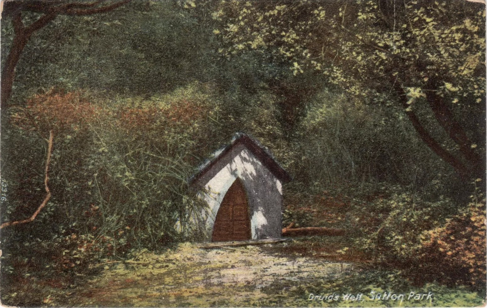
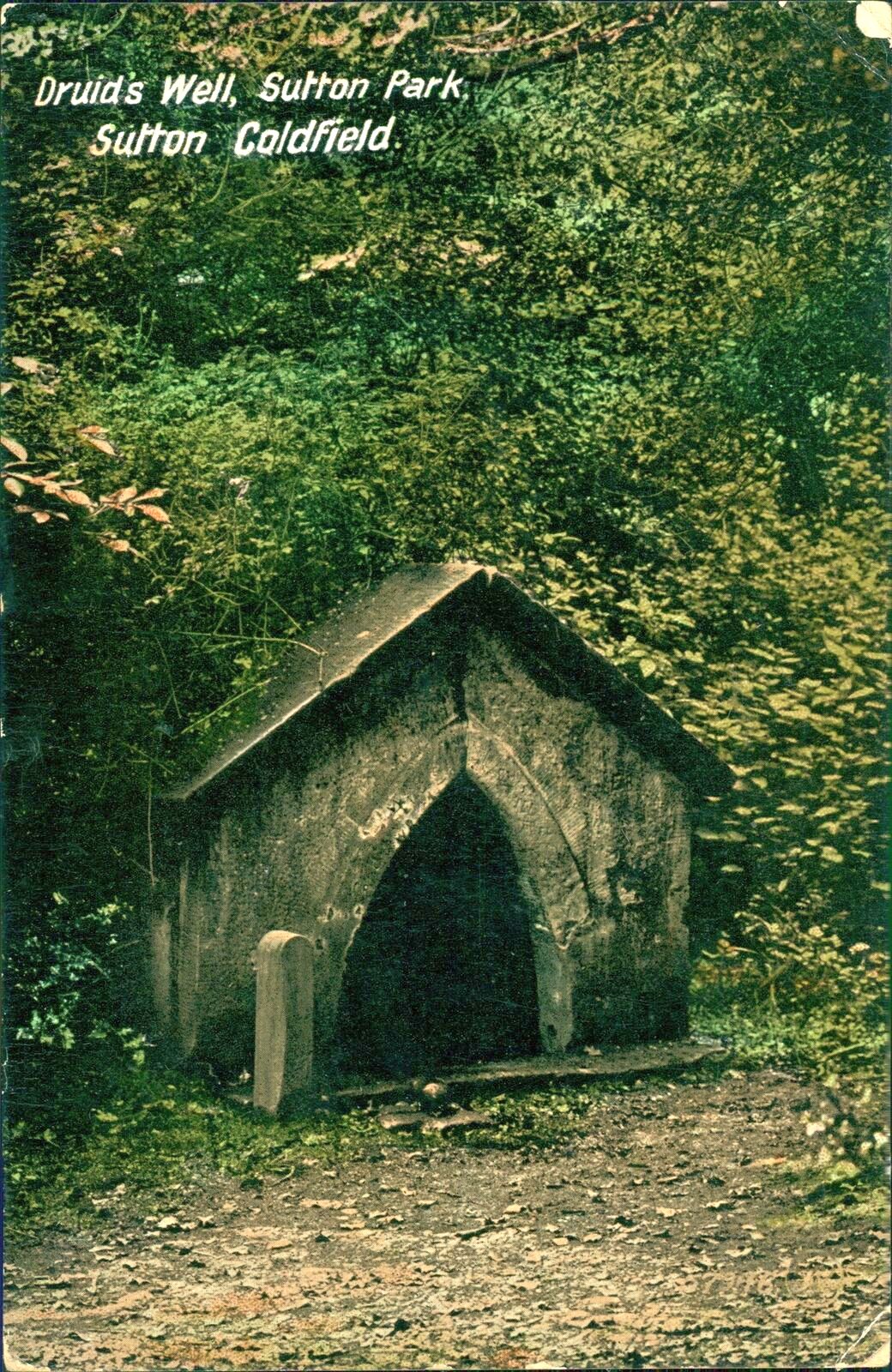
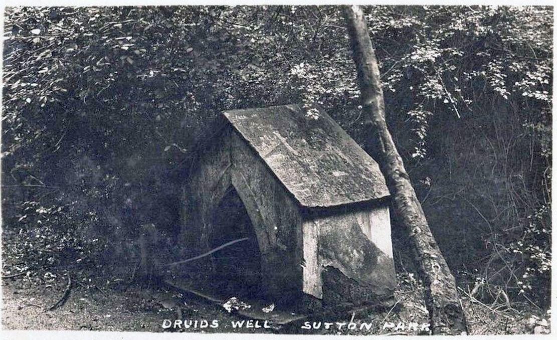
Highlighted on the 1884 Ordnance Survey map of the region and located beyond the far eastern end of Braceridge Lake, this legendary well has seen better days. A small well-house once covered the spring, but all we have left today is little more than a rectangular stone-lined concrete hole-in-the-ground where the waters collect (hopefully some local folk can bring it back to life). But in the 19th century it was well known, much frequented and maintained.
Not much seems to be known about its mythic history, as the traditions surrounding its dual pagan-christian dedication seem to have been forgotten. When the local writer Tom Burgess (1893) came to explore its history, he merely wrote:
“How it came to be called the Druids’ Well is not known, it is scarcely necessary to say that it can have no Druidical connection; it is very probable, however, that it was dedicated to Saint Mary long before the dam of Bracebridge Pool was made by Ralph Bracebridge in the reign of Henry V.”
Druids Well in 1917Druid’s Well in 1932
Jeremy Harte (2008) suggested that this well’s druidic association may have come from a local man, William Hutton who, in the middle of the 18th century, “speculated on a druid sanctuary near Sutton Coldfield.” But before Hutton, the 17th century Staffordshire topographer, Robert Plot, suggested that an arch-druid held residence on Barr Beacon, which is less than three miles west of here. This idea was echoed by Midgley (1904) who told that Barr Beacon “is supposed to have been a Druidical shrine.” Just over three miles to the northwest, the Druid’s Heath (a place-name derived, apparently, from an old family) at Aldridge also had its own array of folklore which, perhaps, may have had something to do with this well’s association. When Roy Palmer (1976) wrote about the Druid’s Well in his folklore survey, he told that Sutton Coldfield,
“is said once to have been the seat of the arch-druid of Britain; perhaps this was his well, which was later christianized.”
So much to choose from…
References:
Bord, Janet, Holy Wells in Britain – A Guide, HOAP: Wymeswold 2008.
Bracken, L., History of the Forest and Chase of Sutton Coldfield, Simpkin Marshall: London 1860.
Harte, Jeremy, English Holy Wells – volume 2, Heart of Albion press: Wymeswold 2008.
Midgley, W., A Short History of the Town and Chase of Suton Coldfield, Midland Counties Herald: Birmingham 1904.
Palmer, Roy, The Folklore of Warwickshire, Batsford: London 1976.
Acknowledgements:Huge thanks for use of the Ordnance Survey map in this site profile, reproduced with the kind permission of the National Library of Scotland.
Holy Well (destroyed): OS Grid Reference – SP 8234 9542
Also Known as:
Our Lady’s Well
Archaeology & History
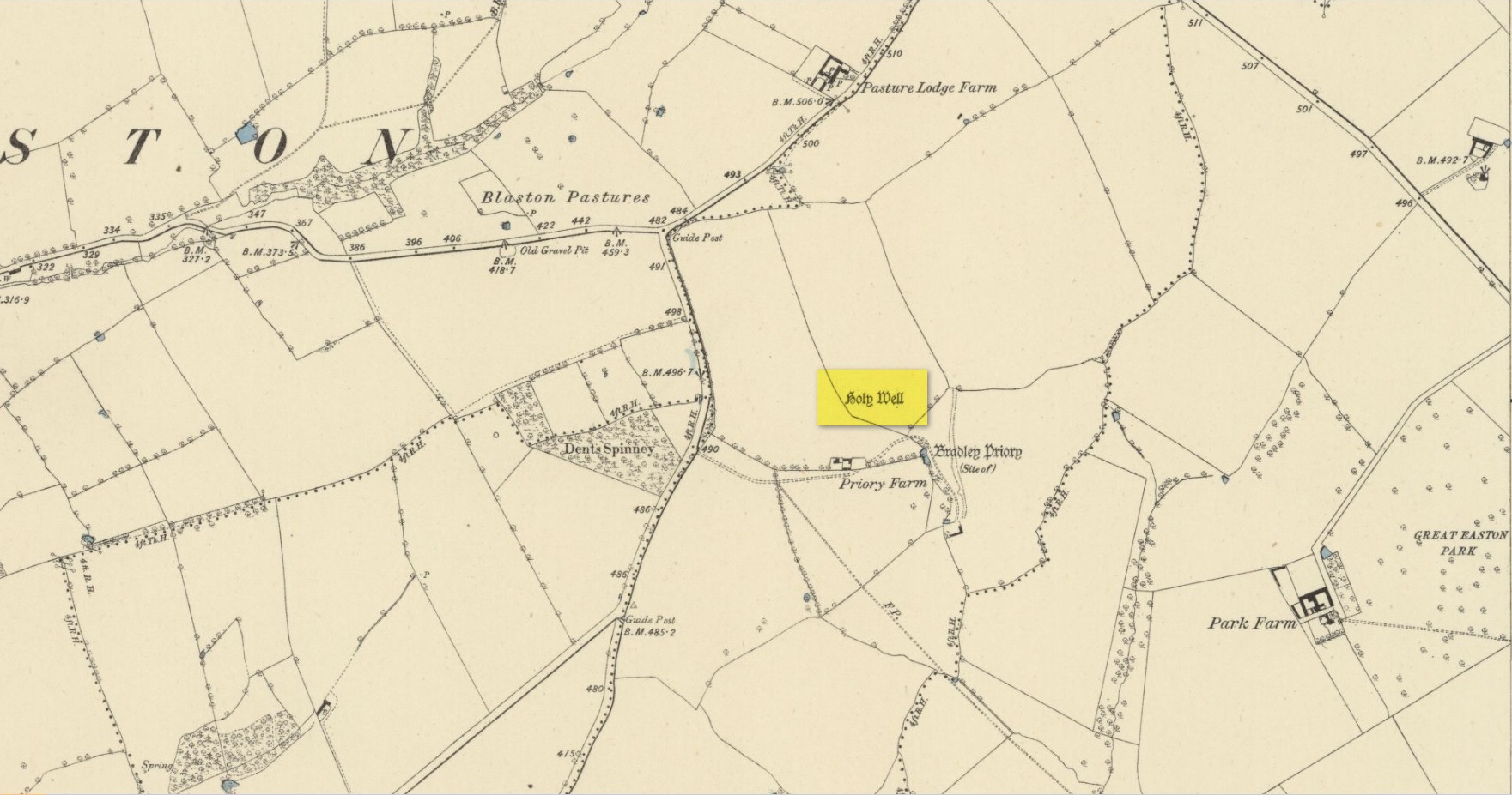
Site shown on 1885 map
There seems to be very little known about this site. It was located in fields just above the site of the Augustinian Priory of St Mary, founded in 1220 CE, where now is Priory Farm, but there seems to be no trace left of it. The great Leicestershire antiquarian John Nichols said the well had been dedicated to Our Lady, the Virgin Mary. This was echoed in John Curtis’ (1831) survey, who told that, “where the Priory formerly stood, a Dwelling House has been erected; and near it is a Well called Our Lady’s Well.” He told that it was deep and “walled below the surface.”
References:
Curtis, John, A Topographical History of the County of Leicester, W. Hextall: Ashby-de-la-Zouch 1831.
Rattue, James, ‘An Inventory of Ancient, Holy and Healing Wells in Leicestershire’, in Transactions Leicestershire Archaeological & Historical Society, volume 67, 1993.
Trubshaw, Bob, Leicestershire and Rutland’s Holy Wells, Heart of Albion: Nottingham 2024.
Acknowledgements:Huge thanks for use of the Ordnance Survey map in this site profile, reproduced with the kind permission of the National Library of Scotland.
Holy Well (destroyed): OS Grid Reference – SP 9848 0822
Also Known as:
St. James’ Well
Archaeology & History
Site shown on 1897 map
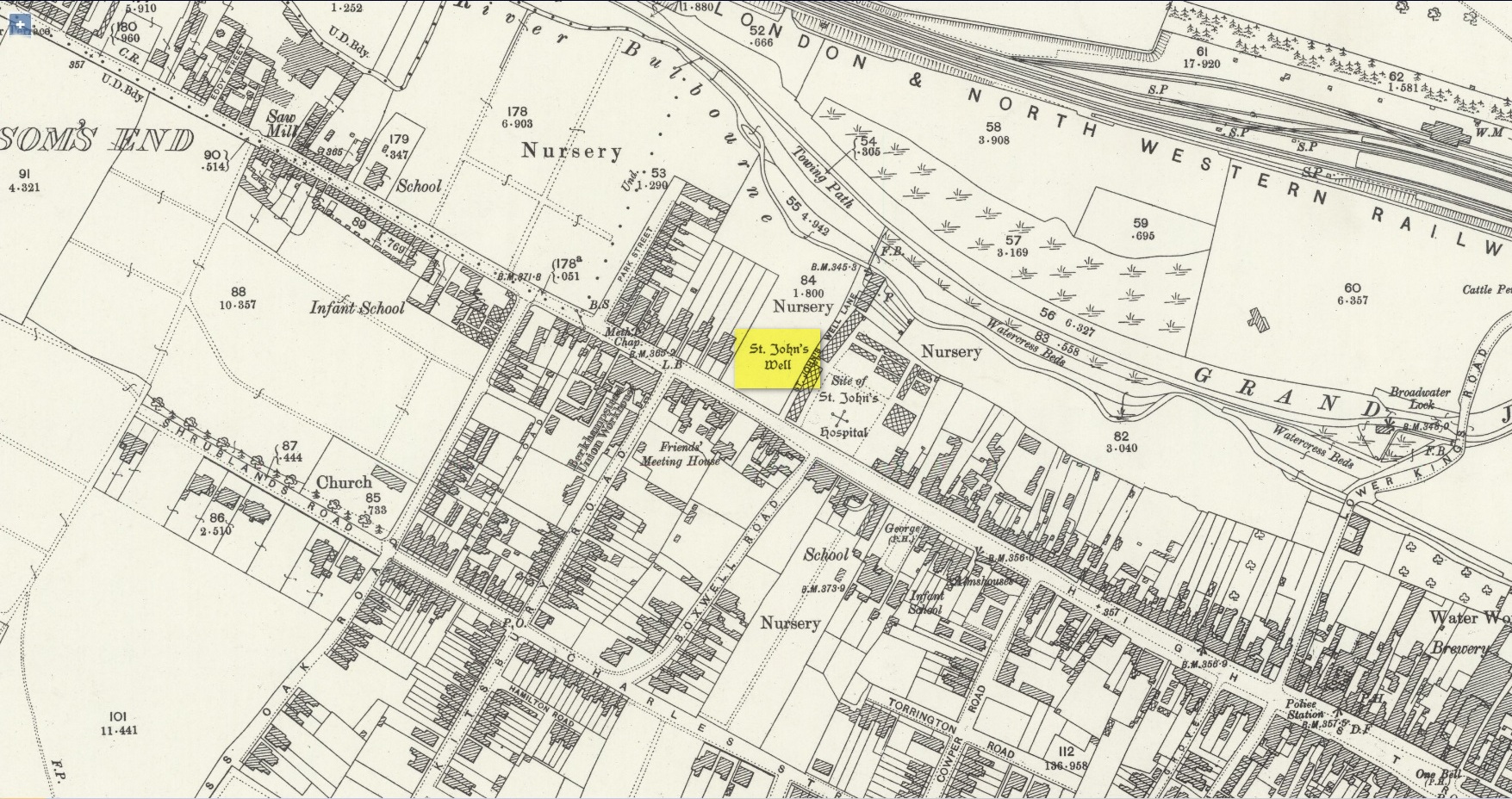
Shown on the early Ordnance Survey maps of the town, Berkhamsted’s holy well was a place of some renown in bygone centuries. Today it is barely remembered. It was initially dedicated to St. James, as it was associated with a chapel dedicated to that saint close by, but it had a change of name when the legendary Brotherhood of St. John the Baptist became the new caretakers, so to speak. As a result of this, its history can be a little confusing to some folk!
In the late 12th century, pagan worship at this site came to the attention of Hugh of Grenoble, the Bishop of Lincoln, who visited the place to stop local folk performing their animistic practices (although the exact nature of such rites were not described, sadly). It didn’t work, obviously; as once the bonkers bishop had gone, local folk would have continued in their old ways, no doubt wondering who the hell the odd incomer had been who was telling them to stop doing what they had always done here at the cost of no one. And so the waters continued to be used under the mythic cover of old St James—for the time being at least.
The well later became a centre of pilgrimage and and a hospital was been built close by dedicated to St James, where leprosy was treated and the curative waters from this well were used. St James’ Day was July 25 and an annual fair was held in Berkhamsted thanks to a Royal Charter of James I in 1619. Hertfordshire traditions relating to St James Day are described in Miss Jones-Baker’s (1974) fine survey on the customs of the county. But change was a-coming when a local monk had a dream that the waters of this “pagan spring” needed to be blessed and dedicated to the virtues of St. John the Evangelist and a shrine built where pilgrims could worship and be healed. And as Jones-Baker (1977) told us,
“The water of St John’s Well were thought to cure a variety of diseases; among these leprosy and scrofula (the King’s Evil) as well as sore eyes. There was also a persistent belief that clothing washed in its waters would impart good health to the wearers.”
In the period when the Protestant Reformation occurred, the well and its immediate surrounds apparently became derelict and overgrown. The Old Ways returned and local folk began to visit the waters again at night and the animistic rituals that would have been taken to other secret places returned to St. John’s Well. In this period a local physician, a Dr. Woodhouse, used the sacred waters as part of magickal rites to exorcise evil spirits!
In spite of the local authorities declaring in 1865 that the water was “unfit for drinking”, local folk later told otherwise. Its waters were still being used in the 20th century and its traditions no doubt retained. As the local writer Dora Fry (1954) told us:
“The families dwelling in the cottages at the Bulbourne end of the lane, just below St John’s Spring, were all remarkably healthy… Some time after the town got its first waterworks (and) the local authorities declared that the well’s water was to be used only for the gardens… but I remember as a child drinking the water from the main spring and its coolness and freshness were delectable on a hot summer afternoon.”
The well was still visible up until the 1930s, when its waters ran down a shallow channel along St John Well’s Lane, but then a shop was built above the site and the well has been lost forever.
References:
Bord, Janet & Colin, Sacred Waters, Granada: London 1985.
Acknowledgements:Huge thanks for use of the Ordnance Survey map in this site profile, reproduced with the kind permission of the National Library of Scotland.
Holy Well (destroyed): OS Grid Reference – NT 2611 7600
Also Known as:
Bonnington Mineral Well
Archaeology & History
Site shown on 1862 map
If we’d have lived 200 years ago and walked several miles downstream from St Bernard’s Well on the Water of Leith, we would have eventually come across this little-known sacred site, sadly destroyed in the 19th century. It was shown on the earliest OS-map on the south-side of the river, enclosed in a small square building with what looks like two entrances, and what appears to be a covering of the spring on the southeast side. Marked as a chalybeate, or iron-bearing well, this would have obviously have had repute amongst local people and would have worked as a tonic or pick-me-up, aswell as fortifying the blood and a having a host of other benefits.
The Ordnance Survey lads wrote short notes about St. Cuthbert’s Well in the Name Book of 1852-53, where they told:
“A Well Situated at Bonnington. Supposed to have been dedicated to St Cuthbert; about 34 years ago the proprietor repaired the well and at the same time erected a house over it, and fitted it up for Visitors who are charged one penny for a drink. The Water of the well has been analysed by Professor Jameson and Doctor Turner and it was found to Contain Salts of Iron; Soda, magnesia and Lime, also Iodine under the form of Hydrisdate of Potash.”
About the same time as Jameson & Turner’s analysis of St. Cuthbert’s waters, one Dr Edward Schweitzer (1845) wrote one of the most detailed chemical essays on wells, ever!—using Bonnington’s holy well as his primary focus. A near-thirty-page essay found that, along with an excess of iron, the medicinal aspects of the waters were due to the following compounds found, per grains, in each pint of water:
Sulphate of Potassa — 2.46554 gr
Sulphate of Soda — 1.51227 gr
Sulphate of Lime — 6.28816 gr
Iodide of Sodium — 0.00728 gr
Bromide of Sodium — 0.07886 gr
Chloride of Ammonium — 9.49939 gr
Chloride of Sodium — 3.82963 gr
Chloride of Magnesium — 3.12017 gr
Nitrate of Soda — 2.02154 gr
Carbonate of Magnesia — 1.70443 gr
Proto-Carbonate of Iron — 0.05807 gr
Proto-Carbonate of Manganese — 0.01535 gr
Ammonia (united to organic matter) — 0.42285 gr
Alumina — 0.02245 gr
Silica — 0.18651 gr
In 1837, a Mr Robert Fergusson was known to be “the keeper of the Mineral Well, Bonnington,” but much of its traditions and history have fallen outside of memory. The site was soon to become another mid-Victorian ‘Spa Well’, where local people would have to pay for water they had always used as Nature intended. In truth, the waters and its well-house were to become a place where the rich Industrialists could heal their infirm mind-bodies, hoping that the destitution they lacked emotionally and spiritually would be washed away in the sacred waters. But it didn’t last long! What little is known about it historically was best described in John Russel’s (1933) essay on Bonnington in the Old Edinburgh Club journal. He wrote:
“Just where the Bonnington mill lade joins the Water of Leith once flowed St. Cuthbert’s Well, an ancient spring named after the patron saint of the once extensive parish of St. Cuthbert’s, and like the now forgotten mineral well of St. Leonard’s near Powderhall, a relic of a superstitious age. As to when this well was so designated history is silent but it was probably before 1606, when the Leith portions of Bonnington, Pilrig and Warriston were, by the Scots Parliament, included in the Parish of North Leith…
“In May, 1750 St. Cuthbert’s Well was found to be possessed of medicinal properties. The Scots Magazine of that year refers to many persons frequenting it. The Well formed part of a building which included a pump room and a reading room. From advertisements in the periodicals of 1819 we learn that it was open from 6 o’clock in the morning and that newspapers were to be found on the table all day. The tenant also issued handbills headed “St. Cuthbert’s Mineral Well, Bonnington”, giving a chemical analysis of the water and a list of the ailments for which it had been found beneficial. The Well disappeared with the re-construction of Haig’s Distillery in 1857. It now lies beneath the buildings immediately west of the chimney stack of Messrs John Inglis and Sons.”
St. Cuthbert’s feast day was March 20 (Spring Equinox) and September 4.
A half-mile southwest of here could once be seen the waters of St. Leonard’s Well, which Ruth & Frank Morris (1982) erroneously thought to have been this Well of St. Cuthbert.
Holy Well (destroyed): OS Grid Reference – SP 4506 4055
Archaeology & History
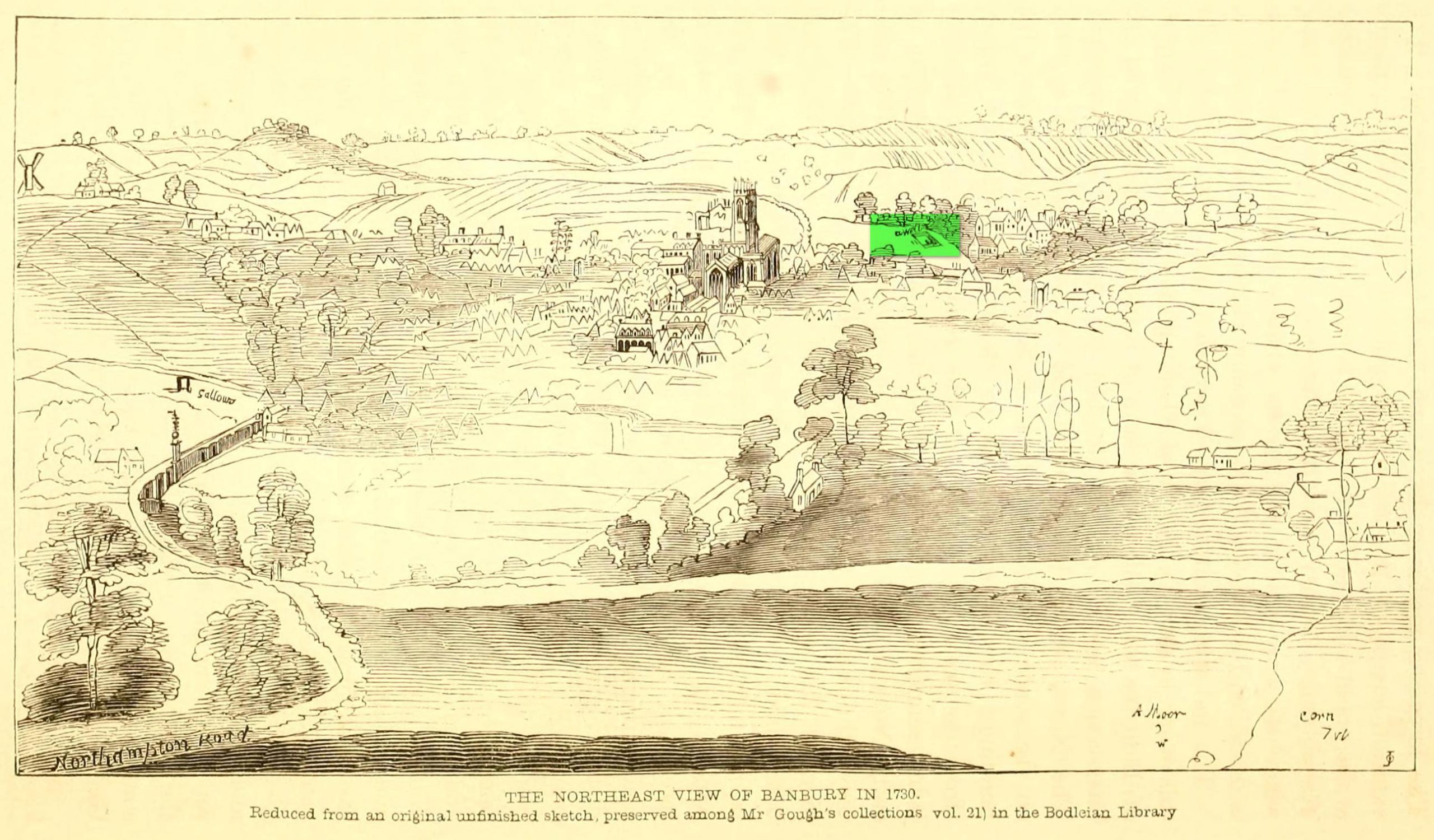
Well highlighted, in 1730
The holy well of Banbury seems to have been destroyed sometime in the second-half of the 19th century, when the industrialists built over the area. When the historian Alfred Beesley (1841) wrote about it, the waters were still running. He told it to be, “a chalybeate spring, well-known and still often visited, situated on the west side of the town, a little north of the footway leading to North Newington.”
The footpath is obviously long gone—as is the well. It’s iron-bearing (chalybeate) properties would have given the waters good fortifying properties, perhaps of some renown to local people yet, according to Mr Beesley, it was a slow-flowing spring. In his brief history of the site, he also gave us the results of a chemical examination of its healing waters, telling us:
“This is called St. Stephen’s Well in a plan of Sir John Cope’s property at Banbury made in 1764. It also appears prominently as “A Well ” in an unfinished view of Banbury made in 1730 (illustrated above)….
The water of this spring is perfectly clear and colourless, having a brisk and slightly chalybeate taste. The stone channel is coated with a light red deposit, and a scum of the same colour appears on the water in parts where stagnant. The spring discharges from half a gallon to one gallon in a minute. In 32 oz. of the water at 60° are,
Carbonic Acid gas, 5 cubic inches
Hydrochlorate Magnesia, 0.21 grains.
Chloride Sodium or common Salt, 0.54
Sulphate Lime, 1.5
Carbonate Lime, 3.8
Protoxide Iron, 0.024
Silica a trace
Total weight of solid contents – 6.074″
Folklore
St. Stephen is an odd character. His annual celebration or feast day in Britain is December 26. (in eastern countries it’s a day later) Rites connected to this character are decidedly heathen in nature. From the 10th century, in England, St Stephen’s Day has been inexorably intertwined with horses, bleeding them on his feast days, apparently for their own health. Water blessed by priests on this day would be kept for the year and used as a medicine for horses during that time. Also on this day, young lads would “hunt the wren” and, once caught, impale it on top of a long pole and take it from house to house. Despite this curious motif being a puzzle to folklore students, Mircea Eliade (1964) explained how this symbolism is extremely archaic and “the bird perched on a stick is a frequent symbol in shamanic circles.”
Eliade, Mircea, Shamanism – Archaic Techniques of Ecstasy, Princeton University Press 1964.
Harte, Jeremy, English Holy Wells – volume 2, Heart of Albion press: Wymeswold 2008.
Johnson, William P., The History of Banbury, G. Walford: Banbury 1860.
Acknowledgements:Huge thanks for use of the Ordnance Survey map in this site profile, reproduced with the kind permission of the National Library of Scotland.
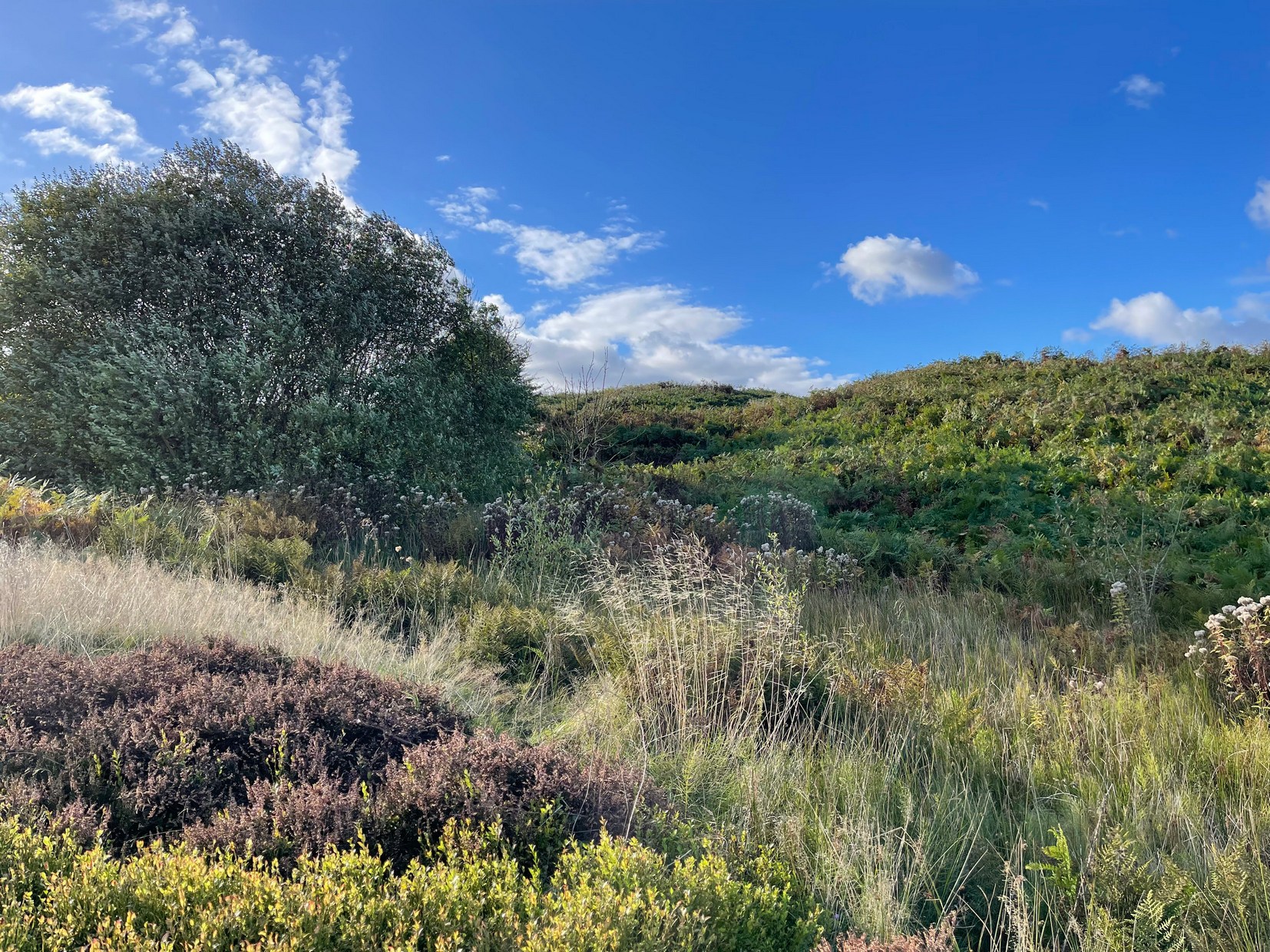
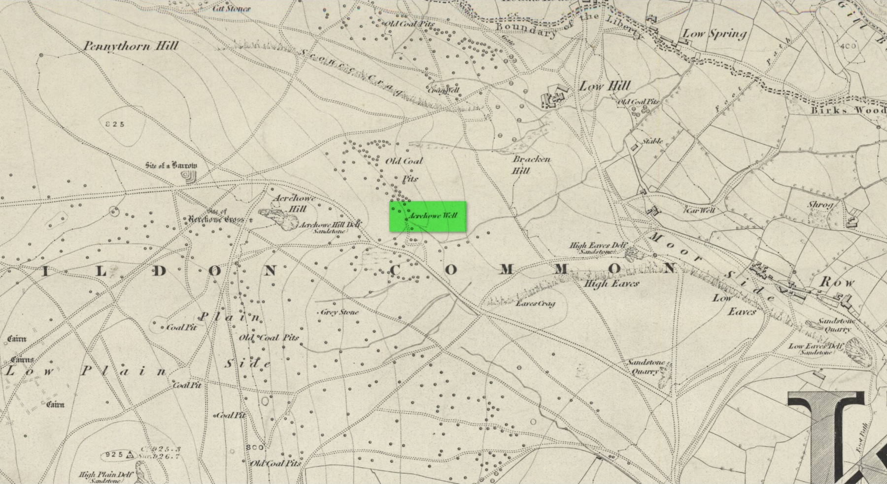
First illustrated on the 1852 Ordnance Survey map of the area and now only visible as a small marshy area, this once fast-flowing well gained its name from the old stone cross (very probably a standing stone before that) four hundred feet west of here, called Acrehowe Cross, now gone. It is possible that this ‘cross’ gave the well a local reputation as a holy well. A solitary path once led to the well, whose waters rise up through a coal seam giving the place its medicinal qualities, which have sadly been forgotten. Up and down this path towards Baildon village one would have regularly met a local character in the 19th century known as “Dinnis” (his real name was Joseph Halliday) who, along with his partner would take ‘kits’ (a large bucket with parallel sides) of water from the well into the village and sell it for a halfpenny each.
Site shown on 1852 map
Later in the 19th century, a cottage was built here (known as Acre Cottage) and gained its water supply from the well. This was curtailed with the construction of the Baildon Moor reservoirs by the roadside, which took the water from both here and the nearby Spink Well (over the hill on the far side of the golf course), leaving us with little more than the trickling water we see today, just a little further down from its original location.
References:
la Page, John, The Story of Baildon, William Byles: Bradford 1951.
Acknowledgements:Huge thanks for use of the Ordnance Survey map in this site profile, reproduced with the kind permission of the National Library of Scotland.
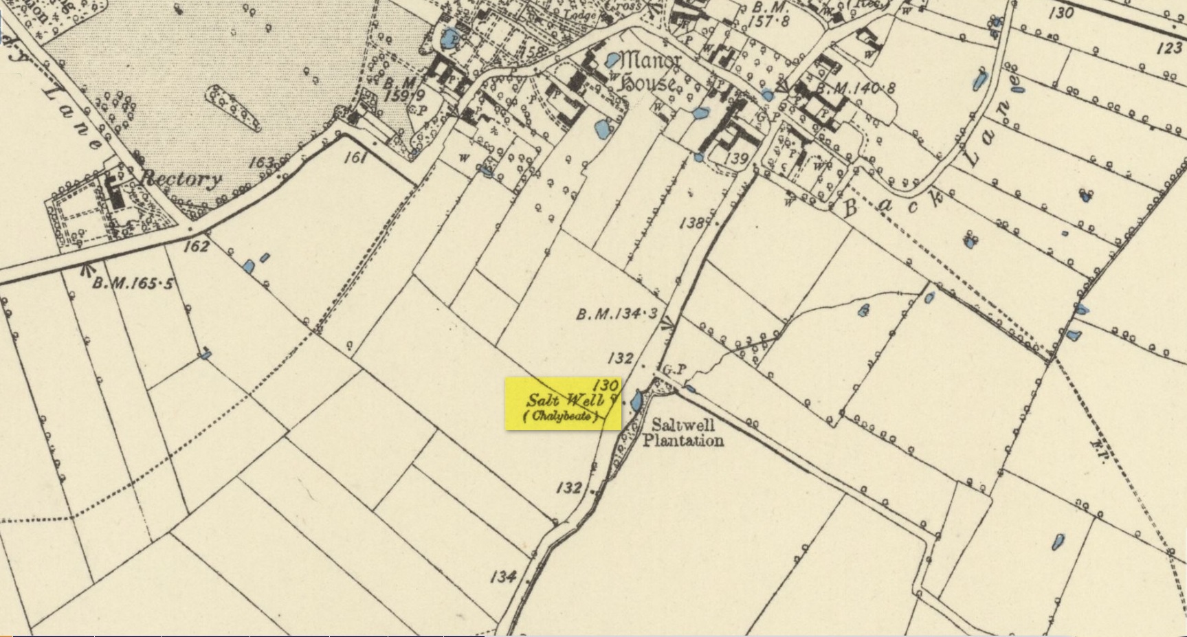
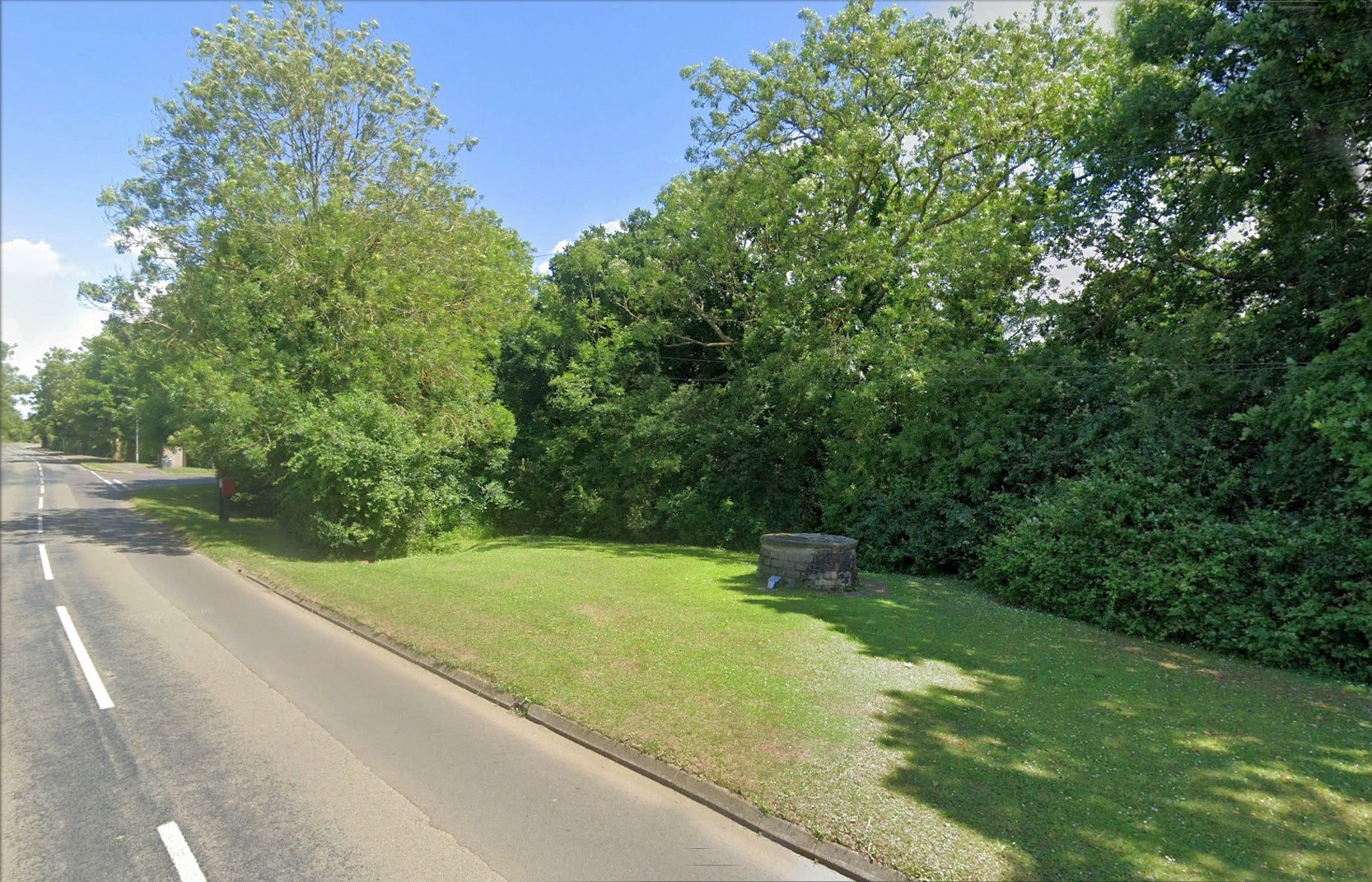
Nice ‘n easy: take the Sedgebrook Road south out of Allington village and, after a few hundred yards, just as you go past Peach Lane, keep your eyes peeled and look into the shrubs that are set back a few yards on the left-hand side of the road. Just there you’ll see a small circular stone structure with a small plague in front of it. That’s the Salt Well.
Archaeology & History
Salt Well by the roadside
Highlighted on the early Ordnance Survey maps of the area, this chalybeate spring was known as both the Salt Well and Holy Well. Mentioned in Ian Thompson’s (1999) work, the waters here arise in a three-foot high pillbox-shaped structure, set into the grass verge just off the roadside between Allington and Sedgebrook. On the early OS-maps it is shown to have originally been on the opposite side of the road. The earliest reference to the well is from 1226 CE and, thereafter, a number of 16th Century wills are recorded making bequests for the maintenance of the well suggesting its considerable importance in bygone centuries—perhaps because it was the only local well that did not dry-up, no matter how severe the drought.
The small plaque at the side of the well states, “This spring has been a water source since the 13th Century and now remains a village landmark.” An analysis of the waters here in 1990 revealed very low levels of iron but noted a high concentration of sodium sulphate.
References:
Thompson, Ian, Lincolnshire Springs and Well, Bluestone: Scunthorpe 1999.
Acknowledgements:Huge thanks for use of the Ordnance Survey map in this site profile, reproduced with the kind permission of the National Library of Scotland.
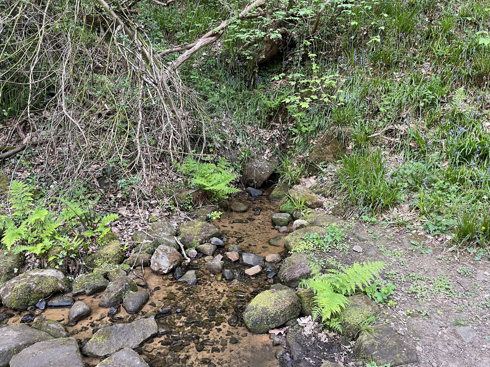
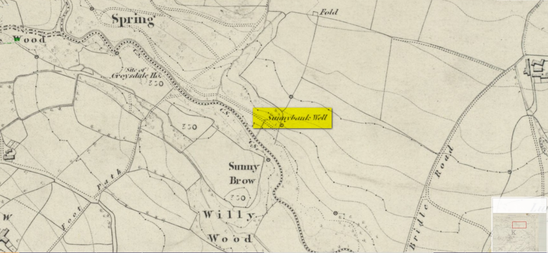
My walk up to this place took me off the main A6038 Hollins Hill road, across from the petrol station and up the scruffy disused road to the hamlet of Tong Park, bending round the houses to the right when they appear. Keep along this old track, then veer right, down the slope and along the footpath and into the trees under the railway arches, keeping on until you reach the lake on your left. At the end of the lake, cross the bridge and follow the footpath as it bends to the left and into the trees. You’ll go over a stile and then about 50 yards along, the stream that crosses the path emerges from a crack in the rocks on your right. You’re here!
Archaeology & History
Site shown on 1852 map
All history and tradition of this site seems long gone. It was shown on the 1852 Ordnance Survey map of the region and doubtless receives its name from the location, as the spring of water emerges from beneath the sloping embankment which is a bit of a sun-trap in Spring and Summer. It makes sense. Although I can find no reference to any medicinal attributes, the waters of Sunnybank Well are cold, fresh and drinkable.
References:
Shepherd, Val, Historic Wells in and Around Bradford, HOAP: Wymeswold 1994.
Acknowledgements:Huge thanks for use of the Ordnance Survey map in this site profile, reproduced with the kind permission of the National Library of Scotland.