St. Sennen’s Well, Sennen Cove, Cornwall

Holy Well (lost):  OS Grid reference – SW 3550 2626

Archaeology & History

The springs of Chapel Idne

Highlighted on the 1888 Ordnance Survey map of Sennen Cove are the remains of Chapel Idne, just above the coast.  Across the road from the chapel on its south-side, and also next to an old inn to its immediate west, springs of water are shown and it would seem more than likely that one of these two would have been the forgotten holy well of Sennen that was described, albeit briefly, in the great Mr Blight’s (1861) literary tour of the area.  He told us that:

“At Sennen Cove was an ancient chapel, called by the people Chapel Idne, the “narrow chapel” being forty-five feet long and fifteen feet wide.  It is now converted into a dwelling. Tradition says it was founded by one Lord of Goonhilly, who possessed dome portion of the land of Lyonesse.  There was a holy well of some repute here also.”

The waters of St. Sennen’s Well were used in an act of ceremonial magick in the Arthurian tale known as the Battle of Vellan-druchar, as told in Robert Hunt’s (1865) great Romances.  An attempted invasion by the Danes was met with by Arthur and nine other kings and the foreigners were slaughtered.

“A few had been left in charge of the ships, and as soon as they learned the fate of their brethren, they hastened to escape, hoping to return to their own northern land. A holy woman, whose name has not been preserved to us, “brought home a west wind” by emptying the Holy Well against the hill, and sweeping the church from the door to the altar.  Thus they were prevented from escaping, and were all thrown by the force of a storm and the currents either on the rocky shore, or on the sands, where they were left high and dry.  It happened on the occasion of an extraordinary spring-tide, which was yet increased by the wind, so that the ships lay high up on the rocks, or on the sands; and for years the birds built their nests in the masts and rigging.

Thus perished the last army of Danes who dared to land upon our western shores.

King Arthur and the nine kings pledged each other in the holy water from St Sennen’s Well, they returned thanks for their victory in St Sennen’s Chapel, and dined that day on the Table-men.

Merlin, the prophet, was amongst the host, and the feast being ended, he was seized with the prophetic afflatus, and in the hearing of all the host proclaimed–

“The northmen wild once more shall land,
And leave their bones on Escol’s sand.
The soil of Vellan-Druchar’s plain
Again shall take a sanguine stain;
And o’er the mill-wheel roll a flood
Of Danish mix’d with Cornish blood.
When thus the vanquish’d find no tomb,
Expect the dreadful day of doom.”

References:

  1. Blight, J.T., A Week at the Land’s End, Longmans Green: London 1861.
  2. Hunt, Robert, Popular Romances of the West of England, 1865.
  3. Straffon, Cheryl, “Chapel Idne and the Holy Well,” in Meym Mamvro no.34, 1997.
  4. Weatherhill, Craig, “A Guide to Holy Wells and Celebrated Springs in West Penwith,” in Meym Mamvro no.4, 1997.

Acknowledgements:  Big thanks for use of the early edition OS-map in this site profile, Reproduced with the kind permission of the National Library of Scotland

© Paul BennettThe Northern Antiquarian

Maiden’s Well, Launceston, Cornwall

Holy Well (destroyed):  OS Grid reference – SX 3285 8477

Archaeology & History

Site of well on 1884 map

Very little is known about this holy well on the north-western side of town that was apparently destroyed sometime in the 19th century; for when the Ordnance Survey lads visited here in 1882, they found no running water but only the location of where it had been and they indicated this on their 1884 map of the area, marked as “Site of.”

It was first mentioned in a short topographical notice in 1582, which told that the “Magden Well in the Quarrie Haye”—along with another well—was “found to be in decay.” (Peter 1885)  Then, when the Ordnance Survey lads resurveyed the area again in 1951, once more they could find no trace of it.

References:

  1. Peter, Richard, The Histories of Launceston and Dunheved, W. Brendon: Plymouth 1885.

Acknowledgements:  Big thanks for use of the early edition OS-map in this site profile, Reproduced with the kind permission of the National Library of Scotland

© Paul BennettThe Northern Antiquarian

Holy Well, Lawhitton, Cornwall

Holy Well:  OS Grid reference – SX 3546 8252

Archaeology & History

Site shown on 1882 OS-map

Highlighted on the 1882 OS-map several hundred yards north of St. Michael’s church, this site seems to have fallen back to Earth as no remains of it have been found in recent visits.  It was described in Charles Henderson’s (1914) notes as the “holy well at Barton Farm”, and was visited by J. Meyrick (1982) in April of 1980, who told that it could be found by taking “the track immediately east of Lawhitton church which runs through the farm of Mr Lancaster…  After going through the yard proceed ¼ mile down track to the valley where you reach a stream and the Well is on the right.”  It was sought after by Cheryl Straffon (1998) but following her visit to find the Well she told that “there was nothing now to see except a kind of natural basin by the small bridge.”

References:

  1. Henderson, Charles, Notebooks of Parochial Antiquities, Unpublished MS 1914.
  2. Meyrick, J., A Pilgrims Guide to the Holy Wells of Cornwall, Falmouth 1982.
  3. Straffon, Cheryl, Fentynyow Kernow: In Search of Cornwall’s Holy Wells, Meyn Mamvro: Penzance 1998.

Acknowledgements:  Big thanks for use of the early edition OS-map in this site profile, Reproduced with the kind permission of the National Library of Scotland

© Paul BennettThe Northern Antiquarian

Holy Well, Trelawne, Cornwall

Holy Well (lost?):  OS Grid reference – SX 2258 5311

Archaeology & History

This spot is where an old field-name has preserved the memory of an all-but-forgotten holy well, known as the “Holywell Ground.”  Although it may have fallen back to Earth, there are two possible spots regarding its position: i) a spring that was marked on the 1882 OS-map at SX 2258 5315, and ii) a “Well” that’s shown on the recent OS-maps (SX 2257 5306).  Hence, the grid-reference I’ve given to this place is the halfway spot between them both. (it has to be pointed out that the “well” on recent maps occurs right next to an old quarry, which are well known to bring forth water sources that were previously deep underground)  Whether or not Sclerder Abbey—about 400 yards west of here and only built in 1843—had anything to do with the sanctifying this well, I do not know.

© Paul BennettThe Northern Antiquarian

Wishing Well, Bone Valley, Madron, Cornwall

Sacred Well (lost):  OS Grid reference – SW 4614 3259

Archaeology & History

It’s difficult to know what to make of this site: whether it was merely a healing well or whether it possessed greater esoteric functions.  In all likelihood it was the latter as many so-called “wishing wells” in earlier centuries possessed oracular attributes.  It’s also difficult to work out precisely where this well happened to be, as we know little about it apart from the singular reference of Quiller-Couch (1894), who told simply that,

“There was also a wishing-well in the Bone Valley; it is now only a small stream, and is not used for purposes of divination.”

Hidden spring on 1878 map
Line of wells on 1908 map

There were a number of wells along the Bone Valley road highlighted on the early OS-map, all of which may have been known to Quiller-Couch at the time, three of which appeared to have streams emerging from them back then: one just above Bosoljack (SW 4556 3319) and one below it (SW 4571 3292), each just off the roadside; but then a slightly more enticing one is hidden a little further down the lane and up the tinier lane to Higher Boskinning, in the trees on the right (east).  Shown on the first OS-map as a simple “spring”, a small stream runs from it and then into the larger Bone Valley Brook which runs towards Penzance.  The solace and quietude of this spot would seem much more favourable than the other two…. but my impressions may be wrong.  It would be good if someone could find this old place…

References:

  1. Quiller-Couch, M. & L., The Holy Wells of Cornwall, C.J. Clark: London 1894.
  2. Russell, Vivien, West Penwith Survey, Cornwall Archaeological Society 1971.

Acknowledgements:  Big thanks for use of the early edition OS-map in this site profile, Reproduced with the kind permission of the National Library of Scotland

© Paul BennettThe Northern Antiquarian

Chapel Well, Botrea, Sancreed, Cornwall

Holy Well (lost):  OS Grid reference – SW 4025 3062

Archaeology & History

Just over a mile northwest of the superb Sancreed Well, we find documentary evidence from 1778 recording the field-name of Chapel Well Close here, although there seems to be no remaining spring or well and nothing is shown on the early OS-maps.  Official records define it as a “medieval well” and speculate that it may have been associated with the nearby Boscence Chapel and possibly dedicated to St. Winwaloe.

References:

  1. Anon., The Church and Parish of Sancreed in the County of Cornwall, Brewer: Sancreed c.1960.

© Paul BennettThe Northern Antiquarian

Lambeth Wells, Lambeth, London, Surrey

Healing Wells (destroyed):  OS Grid Reference – TQ 3094 7889

Also Known as:

  1. Lambeth Spa
  2. Near Well and Far Well

Archaeology & History

This once famous healing or spa well has long gone.  It was located where the buildings that now constitute 104-105 Lambeth Walk presently stand: an area which the great London historian William Thornbury (1878) told was already “a favourite resort of Londoners, and celebrated for the variety of sweet-smelling flowers and medicinal herbs growing there,” complementing the healing waters before and during the spa craze.  The great herbalist John Gerard did his collections here.

I can find no information regarding its early use by our peasant ancestors, so its written history simply begins when it had been appropriated by those well-to-do up-market types who took this medicinal spring for their commercial gain in the early days of the trendy spas.  Supplied by two separate springs known as the Nearer and Farther Wells respectively, the Well House built here was “formally opened in April 1696” and subsequently had almost daily accompaniments of music, including French and country dancing!  But as the popularity of the Lambeth Spa increased, so did its problems.  Phyllis Hembry (1990) told that by July 1715, one visitor to the spa,

“was so depressed to find that the many people there were mostly rakes, whores and drunkards, idlers such as Guard officers, or young pleasure-seeker like attorneys’ clerks, mingling with loose women of the the meanest sort.  The Lambeth Wells also became a public nuisance, so a dancing license was refused in 1755.”

The so-called Great Room which had been the place of great occasions by spa users ended up being the meeting place “for Methodist meetings.” Oh how the winter nights must have flown by…..

There was a decided improvement in the years that followed and social events at the spa increased again.  It became what Thornbury said “was another place of amusement.”  The Lambeth Wells, he wrote,

“were held for a time in high repute, on account of their mineral waters, which were advertised as to be sold, according to John Timbs, at “a penny a quart, the same price paid by St. Thomas’s Hospital.” About 1750, we learn from the same authority, there was a musical society held here, and lectures, with experiments in natural philosophy, were delivered by Dr. Erasmus King and others. Malcolm tells us that the Wells opened for the season regularly on Easter Monday, being closed during the winter. They had “public days” on Mondays, Thursdays, and Saturdays, with “music from seven in the morning till sunset; on other days till two!” The price of admission was threepence. The water was sold at a penny a quart to the “quality” and to those who could pay for it; being given gratis to the poor.  We incidentally learn that there were grand gala and dancing days here in 1747 and 1752, when “a penny wedding, in the Scotch manner, was celebrated for the benefit of a young couple.”

By this time, a rival St. George’s Spa of had been created a short distance away on the parish boundary and with it, the popularity and attendance at Lambeth Wells began to decline.  By the end of the 18th century, the rot had truly set in and its days were finally numbered.

As for the medicinal properties of these wells, little seems to have been recorded.  Aside from repeating the common description of them being mineral waters, William Addison (1951) simply added that they were also purgative.

References:

  1. Addison, William, English Spas, Batsford: London 1951.
  2. Allen, Thomas, The History and Antiquities of the Parish of Lambeth, J. Allen: London 1827.
  3. Allen, Thomas, A History of the County of Surrey – volume 1, Isaac Taylor: London 1831.
  4. Foord, Alfred Stanley, Springs, Streams and Spas of London: History and Association, T. Fisher Unwin: London 1910.
  5. Hembry, Phyllis, The English Spa 1560-1815, Athlone Press: London 1990.
  6. Nichols, John, The History and Antiquities of the Parish of Lambeth, J. Nichols: London 1786.
  7. Rattue, James, The Holy Wells of Surrey, Umbra: Weybridge 2008.
  8. Sunderland, Septimus, Old London Spas, Baths and Wells, John Bale: London 1915.
  9. Thornbury, William, History of Old and New London – volume 6, Cassell: London 1878.

Links:

  1. Lambeth Wells on the Vauxhall History website

© Paul BennettThe Northern Antiquarian

Horley Green Spa, Halifax, West Yorkshire

Healing Well:  OS Grid Reference – SE 10263 26561

Also Known as:

  1. Horley Green Well
  2. Spa Well

Archaeology & History

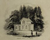
William Alexander’s 1840 sketch of the Spa house

The historian William Addison (1951), in his history on the subject, told how “the spas began as holy wells”; and although no direct accounts are left of early dedications here, the remnants of Mayday traditions tell us there were more archaic goings-on before the waters were taken by the aristocrats.  Once it had been designated as a spa, the waters were covered and a typical Spa House constructed over them.  From hereon, for more than a century, the waters were accessible only to those with money who wished their ailments to be treated.

Between the end of the 18th to the end of the 19th century, the Horley Green Spa was a very prominent ingredient in the history of Calderdale.  A chalybeate or iron-bearing spring, its waters were directed into a large underground cistern covered by metal.  Thomas Garnett (1790) was the first to write about it, telling us:

“The Horley Green water is quite pellucid—sparkles when poured out of one glass into another—and has a sharp, aluminous, styptic taste, not unlike ink. The taste is not unpleasant when the water is taken from the springhead and drank immediately.”

He went on to espouse the waters to be good in healing bone and rheumatic diseases, giving many first-hand accounts from people in Yorkshire and beyond who used the waters here with apparent success, including one case of curing diabetes!  Its reputation was later reinforced in a book by William Alexander (1840), who told us how,

“I unhesitatingly affirm that the Horley Green Spa possesses a very strong claim to be regarded as a powerful tonic and chalybeate.”

By the time those words were written, it had already gained a considerable reputation and many were those who’d received treatment.

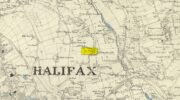
Spa House on 1894 map

A years after Alexander, the roving doctor A.B. Granville (1841) visited Horley Green—who described it as “a renowned steel-water Spa”.  But at the same time he reported how its popularity had started to decline.  But, via one Mr West, he did leave us with a greater chemical analysis of the Horley Green waters in an attempt, once more, to certify and prove its curative properties.  Their results found the waters to possess, in varying quantities, lime, magnesia, silica, iron oxide, sulphur and silica—all of which further attributed the science of its medicinal actions.   A number of case histories of the people cured here can be found in the works of Granville, Garnett and Alexander.

The well-house that stood here eventually fell into disuse.  When it was eventually restored as someone’s home in the the late 20th century, the disused spring was found beneath the foundations, filled with stones.

Folklore

Horley Green’s spa well came about as a result of local people visiting the site around Beltane, probably for centuries before the aristocrats and early pharmacists took their hand to the place.  But once the spa became renowned, people could only gather here “on the first Sundays in the month of May,” with Sunday being that legendary ‘day of the lord’ crap, to which the people would abide to save them from prosecution.  It is obvious though that it had been used as a place of magick thanks to the snippets of lore which have found their way into local history books.  We read how, at 6am, people gathered here, to such an extent that the roads were completely crowded.  Those who arrived first were given bags of nuts: an archaic traditional motif found at many pre-christian wells in Britain.  Occultists and ritual magickians amongst you will note the time when folk frequented the well, at 6am: the time when many nature-spirits are invoked for full effects.  We find this time echoed in the ritual gatherings at Lady or St. Anne’s Well in Morley, just a few miles to the east.

References:

  1. Addison, William, English Spas, Batsford: London 1951.
  2. Alderson, Frederick, The Inland Resorts and Spas of Britain, David & Charles: Newton Abbot 1973.
  3. Alexander, William, The Horley Green Mineral Water, Leyland & Son: Halifax 1840.
  4. Alexander, William, “On the Mineral Springs of the Parish of Halifax,” in Proceedings Geological & Polytechnic Society, West Riding, Yorkshire, volume 1, Edward Baines: Leeds 1849.
  5. Crabtree, John, Concise History of the Parish and Vicarage of Halifax, Hartley & Walker: Halifax 1836.
  6. Garnett, Thomas, Experiments and Observations on the Horley-Green Spaw, near Halifax, George Nicholson: Bradford 1790.
  7. Granville, A.B., Spas of England, Henry Colburn: London 1841.
  8. Hembry, Phyllis, The English Spa 1560-1815, Athlone Press: London 1990.
  9. Short, Thomas, The Natural, Experimental and Medicinal History of the Mineral Waters of Derbyshire, Lincolnshire and Yorkshire, privately printed: London 1724.
  10. Short, Thomas, A General Treatise on Various Cold Mineral Waters in England, privately printed: London 1765.

© Paul BennettThe Northern Antiquarian

St. George’s Well, Edinburgh, Midlothian

Holy Well:  OS Grid Reference – NT 24401 74070

Also Known as:

  1. Canmore ID 133173

Getting Here

St George's Well on 1851 map
St George’s Well on 1851 map

In Edinburgh, get to the west-end of Princes Street (nearest the castle), and where there’s the curious mess of 6 roads nearly skewing into each other, head down Queensferry Street for 450 yards until, just before you go over the bridge, walk down Bells Brae on your left, then turn right down Miller Row where you’ll see the sign to St. Bernard’s Well.  St. George’s Well is the small, dilapidated spray-painted building right at the water’s edge 200 yards before St. Bernard’s site.

Archaeology & History

Compared to its companion holy well 200 yards downstream, poor old St. George’s Well is a paltry by comparison, in both historical and literary senses.  The site was said to have been “set up in competition with St Bernard’s Well but never achieving its purpose”, wrote Ruth & Frank Morris (1982)—which is more than a little sad.  Not on the fact that it failed, but on the fact that some halfwits were using local people’s water supply to make money out of and, when failing, locked up the medicinal spring and deny access to people to this day!

In Mr Grant’s Old & New Edinburgh (1882), the following short narrative was given of the site:

“A plain little circular building was erected in 1810 over (this) spring that existed a little to the westwards of St. Bernard’s, by Mr MacDonald of Stockbridge, who named it St. George Well.  The water is said to be the same as the former, but if so, no use has been made of it for many years…”

St George's Well, looking N
St George’s Well, looking N
St George's Well, looking SW
St George’s Well, looking SW

The association to St. George was in fact to commemorate the jubilee of King George III that year.  If you visit the place, the run-down little building with its grafitti-door has a small stone engraving etched above it with the date ‘1810’ carved.

As the waters here were found to possess mainly iron, then smaller quantities of sulphur, magnesia and salts, it was designated as a chalybeate well.  Its curative properties would be very similar to that of St. Bernard’s Well, which were very good at,

“assisting digestion in the stomach and first passages … cleansing the glandular system, and carrying their noxious contents by their respective emunctories out of the habit, without pain or fatigue; on the contrary, the patient feels himself lightsome and cheerful, and by degrees an increase to his general health, strength and spirits.  The waters of St. Bernard’s Well operates for the most part as a strong diuretic.  If drunk in a large quantity it becomes gently laxative, and powerfully promotes insensible perspiration.  It likewise has a wonderfully exhilarating influence on the faculties of the mind.”

References:

  1. Bennett, Paul, Ancient and Holy Wells of Edinburgh, TNA: Alva 2017.
  2. Grant, James, Cassell’s Old and New Edinburgh – volume 3, Cassell, Petter Galpin: London 1882.
  3. Harris, Stuart, The Place-Names of Edinburgh, Gordon Wright: Edinburgh 1996.
  4. Hill, Cumberland, Historic Memorials and Reminiscences of Stockbridge, the Dean and Water of Leith, Robert Somerville: Edinburgh 1887.
  5. MacKinlay, James M., Folklore of Scottish Lochs and Springs, William Hodge: Glasgow 1893.
  6. Morris, Ruth & Frank, Scottish Healing Wells, Alethea: Sandy 1982.
  7. Royal Commission on the Ancient & Historical Monuments, Scotland, Inventory of the Ancient & Historical Monuments of the City of Edinburgh, HMSO: Edinburgh 1951.

© Paul Bennett, The Northern Antiquarian 


Wanstead Spa, Redbridge, London, Essex

Healing Well (lost):  OS Grid Reference – TQ 40 87

Also Known as:

  1. Wanstead Spring

Archaeology & History

The exact location of this site remains a mystery.  Addison (1951) mentions it as being “close to the Blake Hall Road” where a drinking fountain was erected, but notes that this was not the original site of the spring.  It was obviously a medicinal spring of some renown to the local people, before it was appropriated by the wealthy to turn it into a ‘spa well’.  In doing so, it brought the attention of those curious lords and ladies, along with King James himself, adorning themselves in usual view as important people, and playing the part in social gatherings, as folks did at those spa wells.  But the fad didn’t last long and the spa never really caught on.  One account tells how it was a dangerous place for the rich and wealthy to visit!  Locals can and do get pissed-off if you steal their basic water supplies!

The primary description of the site is that afforded by Christy & Thresh (1910) in their excellent survey of Essex waters.  With no mention of the unimportant local people (!), they told how it was “first discovered” in the early 17th century:

“John Chamberlain, the news-letter writer, writing from London to Sir Dudley Carleton, on 23 August 1619, says:

“‘…We have great noise here of a new Spaa, or spring of that nature, found lately about Wansted; and much running there is to yt dayly, both by Lords and Ladies and other great companie, so that they have almost drawne yt drie alredy; and, yf yt should hold on, yt wold put downe the waters at Tunbridge; wch, for these three or foure yeares, have ben much frequented, specially this summer, by many great persons; insomuch that they wch have seene both say that yt [i.e., Tunbridge] is not inferior to the Spaa [in Belgium] for goode companie, numbers of people, and other appurtenances.”

“We have been quite unable to ascertain anything as to the part of Wanstead parish in which this spring was situated. In all probability, it was quite a small spring. One may infer as much from Chamberlain’s statement that, within a short time of its discovery, the company resorting to it had “almost drawn it dry.” If such was the case, the spring was, no doubt, soon deserted and ultimately forgotten.

“Mr. Walter Crouch, F.Z.S., of Wanstead, whose knowledge of the history of the parish is unequalled, writes us : —

“I have always had the idea that this Mineral Spring was not at the Park end of our parish, which abuts on Bush wood and Wanstead Flats, but in the vicinity of Snaresbrook and on the road which leads to Walthamstow; but it is possible that it was in the grounds of ‘ The Grove ‘ (now cut up and built over). The spring is not marked on Kip’s View (1710), nor on Rocque’s large Map (1735), nor on Rocque’s still larger map of a few years later.”

“Under the guidance of Mr. W. Ping, F.C.S., of Wanstead, Mr. Christy has visited two springs at Snaresbrook — namely, that known as the ‘Birch Well’, in the Forest, near the Eagle Pond, and a spring in the grounds of ‘The Hermitage’; but neither of these is credited locally with being a mineral spring and neither has any appearance of being such. Since then, Mr. Ping has written us as follows: “I have spoken with the oldest inhabitant of Wanstead, a Mr. Merryman, whose knowledge, both local and national, is remarkable and accurate. He tells me that the only Mineral Spring he ever heard of in Wanstead was in the grass bordering the roadside nearly opposite the house, in the Blake Hall Road, formerly occupied by Lord Mayor Figgis, and now by Sir John Bethell, M.P.  This spring he remembers well. Its water was chalybeate and left considerable reddish deposit. People came and drank it to give them an appetite. They used to kneel down and drink it from their hands, and also took it away in bottles. Others used to bathe their ankles in it to make them strong. Mr. Merryman adds that, about 1870, drainage operations deprived the spring of its water. The fountain, which has since been put up near its site, supplies waterworks water only.”  Mr. Ping adds that, recently when deeper drainage operations were in progress at the spot, water of a very markedly ferruginous character was encountered. This is no evidence that this spring was identical with that which came into prominence in 1619, but very likely it was.

“Mr. Dalton expresses the opinion that, if either surmise as to the position is correct, seeing that the comparison with the Tunbridge Wells chalybeate water was sound, the well in question probably yielded a ferruginous water from the Glacial (?) gravels of the Snaresbrook plateau at their contact with the pyritous London Clay.”

References:

  1. Addison, William, English Spas, Batsford: London 1951.
  2. Christy, Miller & Thresh, May, A History of the Mineral Waters and Medicinal Springs of the County of Essex, Essex Field Club: Stratford & London 1910.
  3. Hembry, Phyllis, The English Spa 1560-1815, Athlone Press: London 1990.

© Paul Bennett, The Northern Antiquarian