If you start from the Castleton (2) carving, in the first small birch copse closest to the road, walk to its southeast side where there’s a small break before the next small birch copse begins which runs along the raised rocky crag to the southeast. Walk along the back lower east-side of these birches for about 100 yards until you reach a break in the copse (the next lot of trees are another 30-40 yards further on) and from here walk up the slope onto the first flat piece of rock on the crag itself. Zigzag hereabouts until you’re about two or three yards from the edge.
Archaeology & History
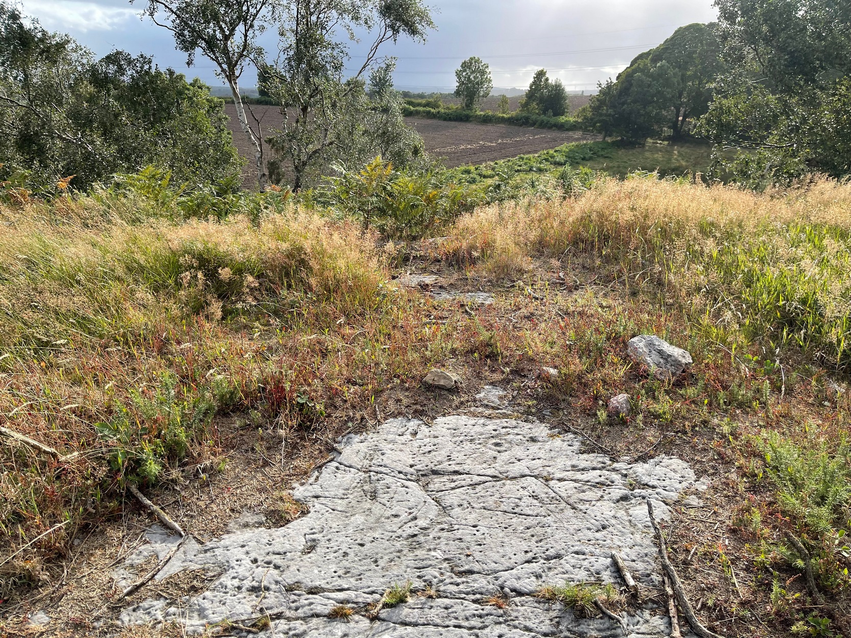
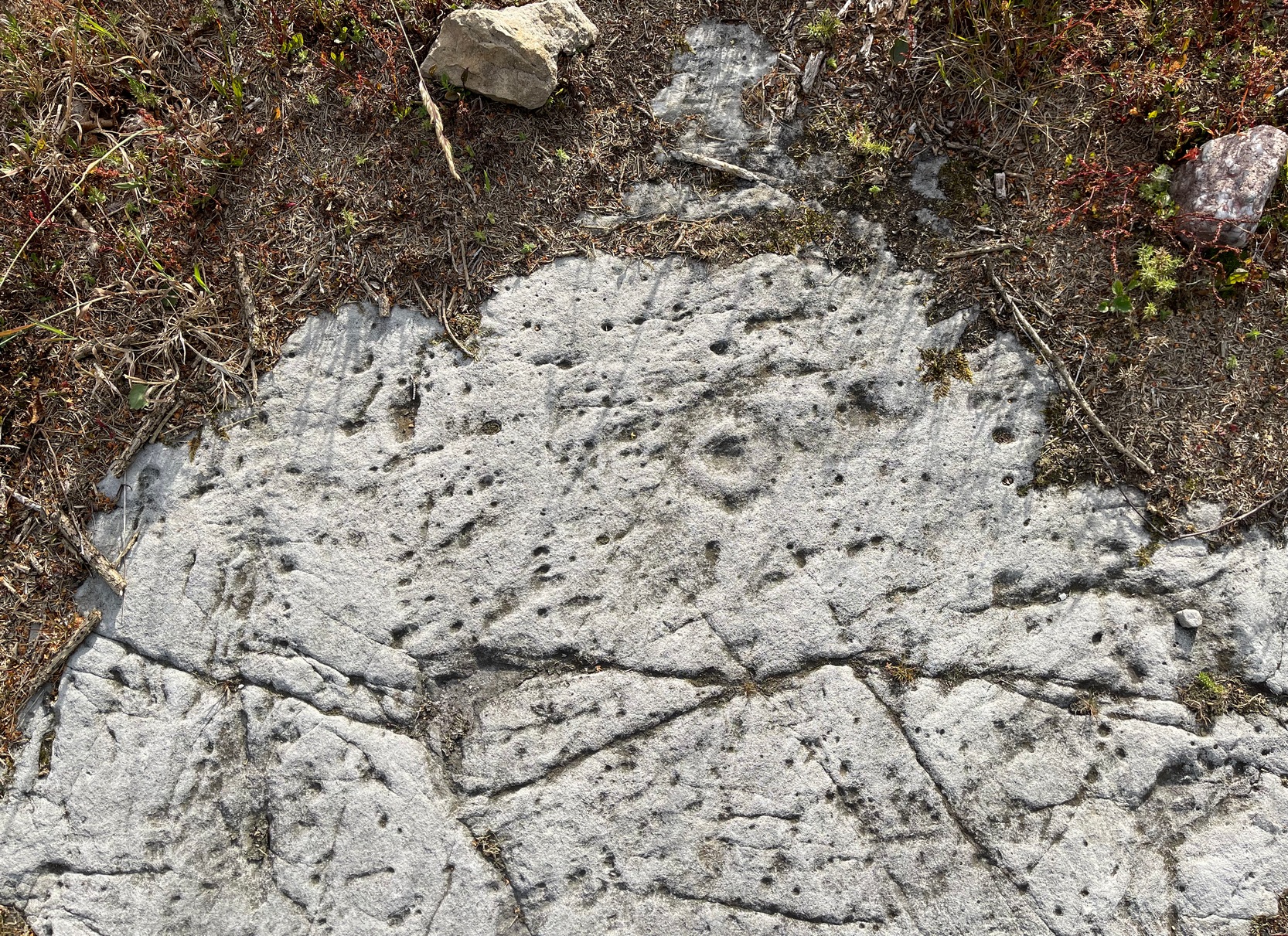
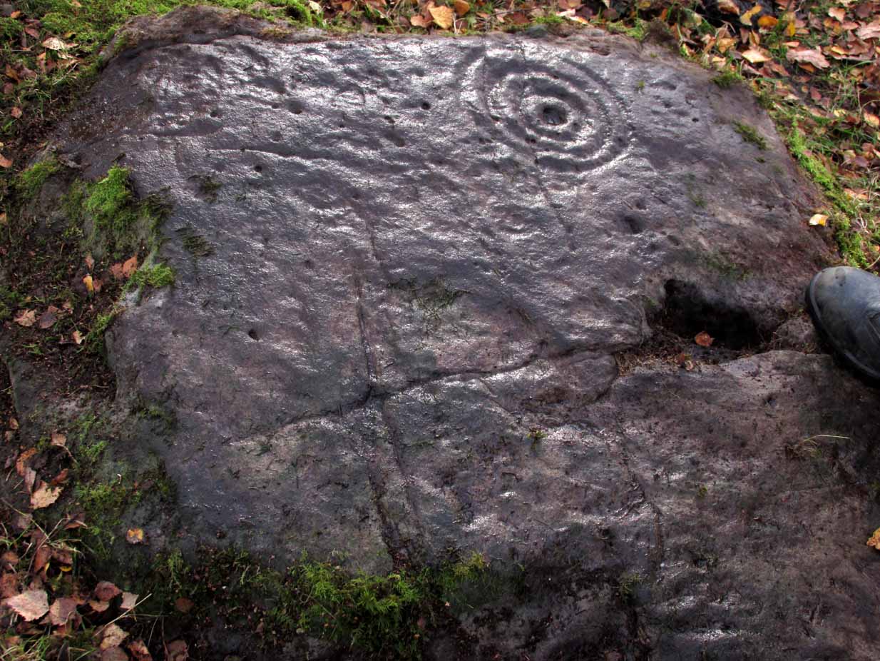
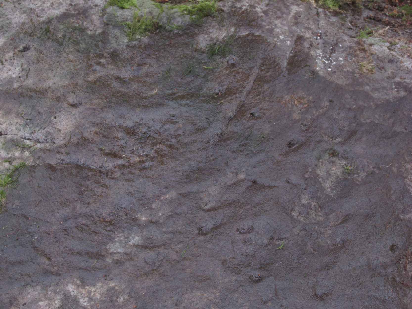
Single cup-and-ring
Once this rock surface is covered again by Nature’s carpet, you’ll struggle to find it. Unlike many of its more ornate neighbours, this seems to be a lonely solitary cup-and-ring design, cut near the edge of a large level piece of otherwise blank rock. Numerous geological nicks and scratches scatter the same surface, but the carved element is easy enough to see, as the photos here show. It was rediscovered in the 1980s by Morris & van Hoek (1986) who described it simply as “a single cup and one ring, 8cm in diameter on horizontal rock.” There may well be additional elements to this design beneath the soil.
References:
Morris, Ronald W.B. & van Hoek, Maarten, “Stirling District: Castleton 4d; Castleton 5e,” in Discovery & Excavation, Scotland, 1986.
Acknowledgments: Massive thanks to Thomas Cleland for helping to make this site visible again.
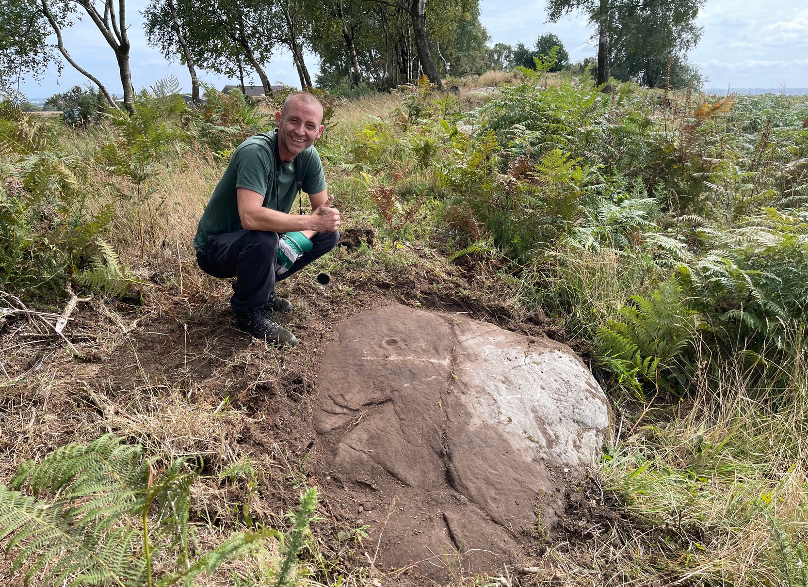
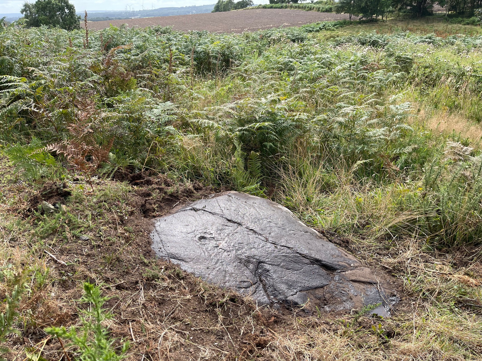
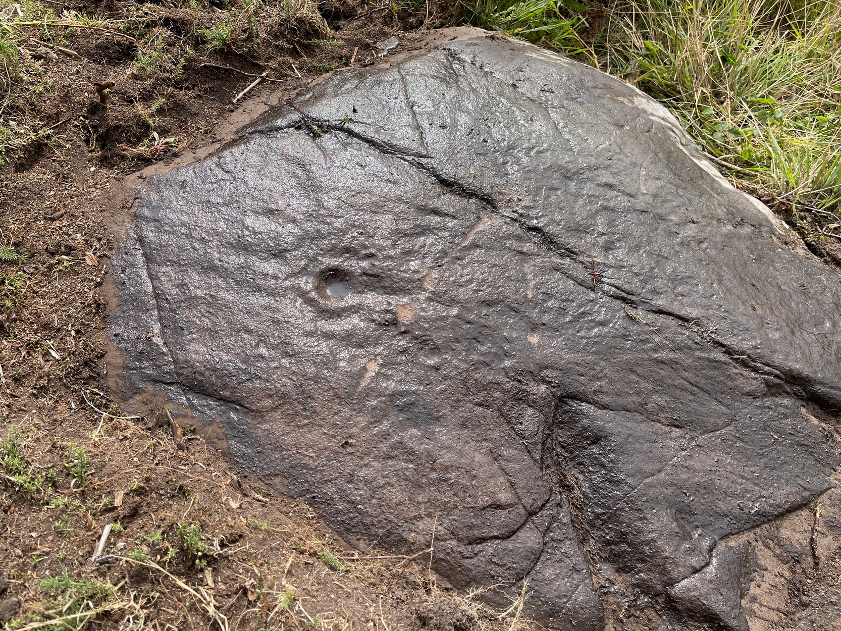
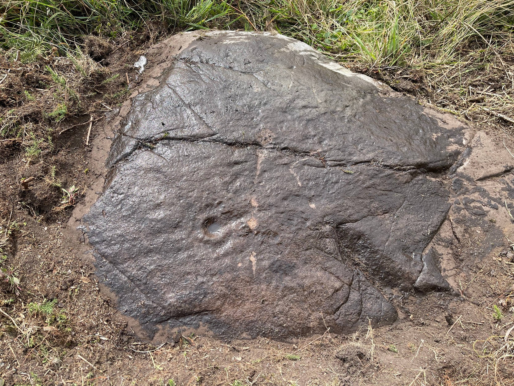
Start from the Castleton (2) carving, in the first small birch copse closest to the road and walk to its southeast side where there’s a small break in the trees before the next small birch copse begins, which runs along the raised rocky crag to the southeast. Walk to the front or western side of the trees there and along the very edge of the low crag. About thirty yards along, right on the edge of where the rocks begin, look for the smooth sloping earthfast boulder (about 20 yards before the mighty nine-ringer of Castleton 7). Rummage around and you’ll find it.
Archaeology & History
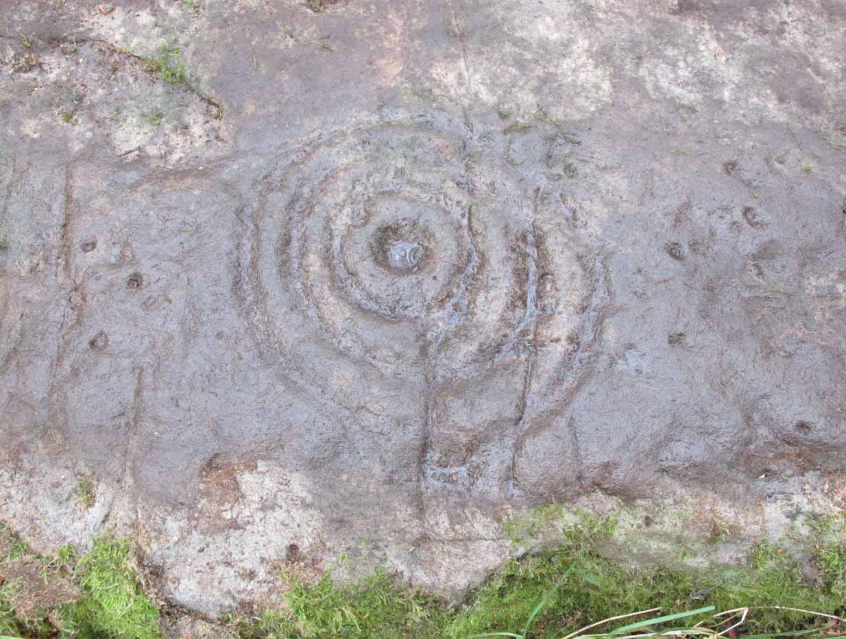
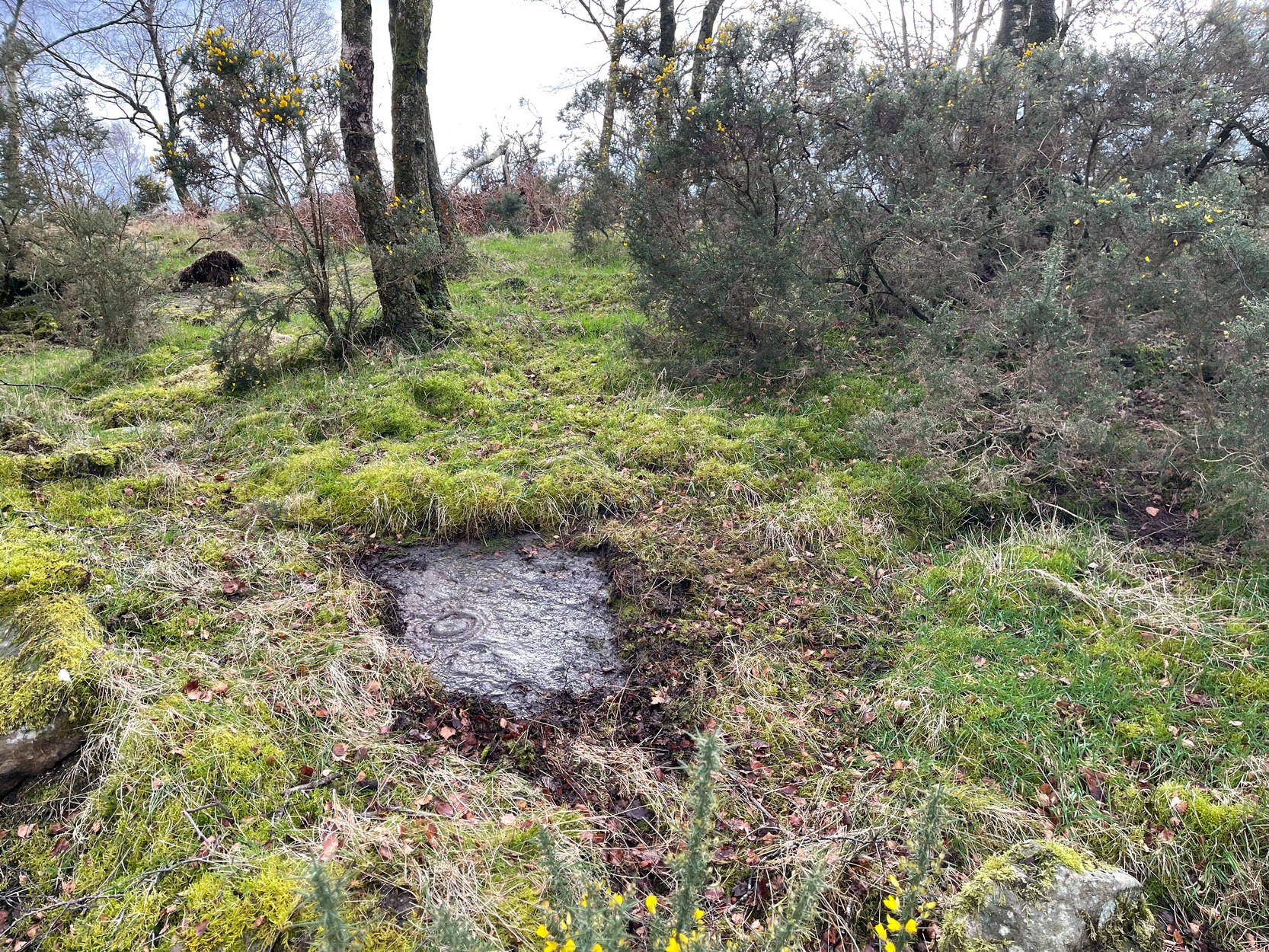
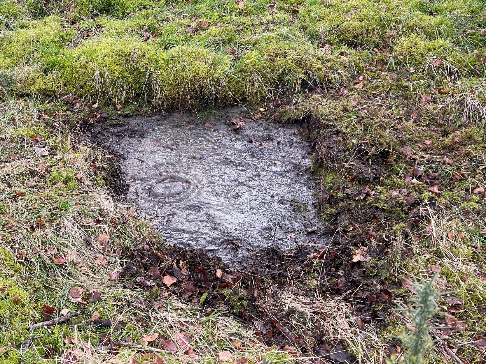
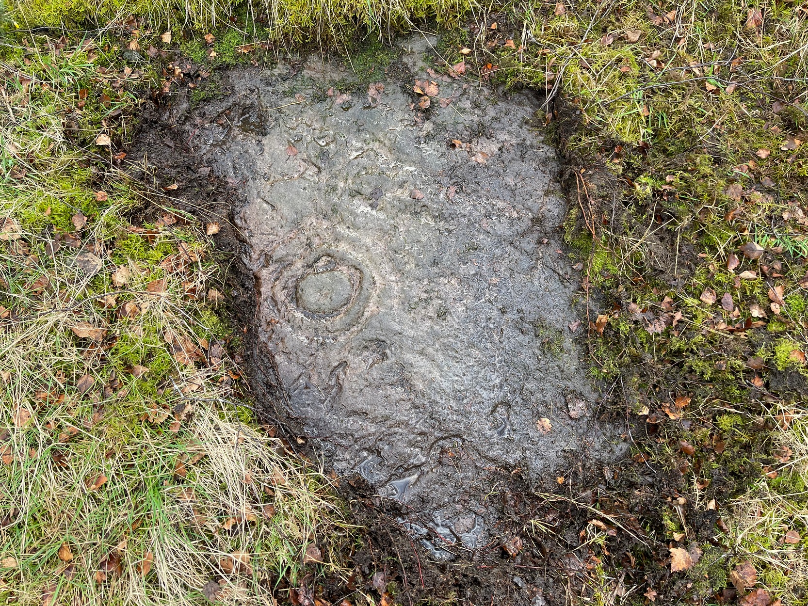
Castleton (7e) carving
This newly recorded petroglyph was rediscovered by Thomas Cleland on August 6, 2025. Initially it was thought to consist of just a single cup-and-ring with an opening from which a carved line ran outwards; but, once wet, there seemed to be the beginning of an outer second-ring on its left-side. You can see it clearly in the photos. And, the more we looked, the more it seemed there were one or two other very faded elements.
Above the main cup-and-ring is a faint, shallow cup-marking and surrounding this appears to be an incomplete dumb-bell-shaped ‘ring’ that you can only just make out in the photos. It’s very faded and would seem to pre-date the primary design by some considerable time (unless, of course, it was merely ‘outlined’, so to speak and never completed).
Cup & ring & faint ‘bell’Cup & ring & faint ‘bell’
Both Tom and I are convinced that there’s more to this carving than is presently visible. The rock is covered in deeply compacted soil and it would require a lot of work to uncover the rest of it. A job for the future maybe…..
Note to self: This carving and all the others in the Castleton complex need to be fully re-catalogued as their indexing is haphazard through various academic tomes and websites.
Acknowledgements: Massive thanks to Thomas Cleland for locating this carving, for the first time in millenia. 🙂
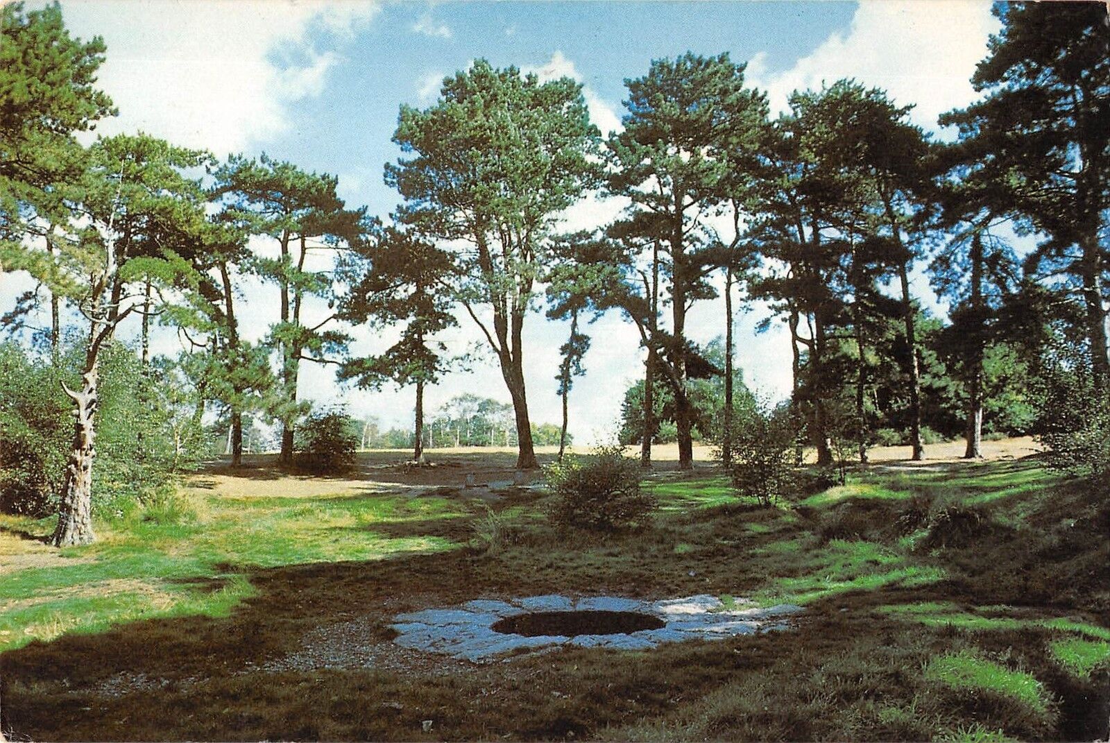
There are numerous ways to get here from all directions: i) from the west-side of Wimbledon Common, on the Robin Hood’s Way A3 road, keep your eyes peeled for the small crossroad of Robin Hood Lane and Road, obivously taking the one into the park. Keep on the dead straight Robin Hood Ride path until your hit the carpark ¾-mile on; and from here, bear sharp left (NW) for 250 yards or so, where a small slope down on your left takes you there; or, ii) from Wimbledon village side on the A219 Parkside A219 road, where the War Memorial stands, head onto the Common along The Causeway, past the Fox & Grapes going on Camp Road, then up the Sunset Road towards the carpark. And then, once again go NW for 250 yards or so, where the small slope on your left takes you there. You’ll find it.
Archaeology & History
Described by William Bartlett (1865) as “the never-failing spring of water, improperly called the Roman Well”, its constant flow was severely tested in the great drought of 1976—and it kept on flowing. Only just though! It was highlighted on the early Ordnance Survey map with the plain name of the Springpond Well. The great historian and folklorist Walter Johnson (1912) gave us the best historical resumé of the site, telling that,
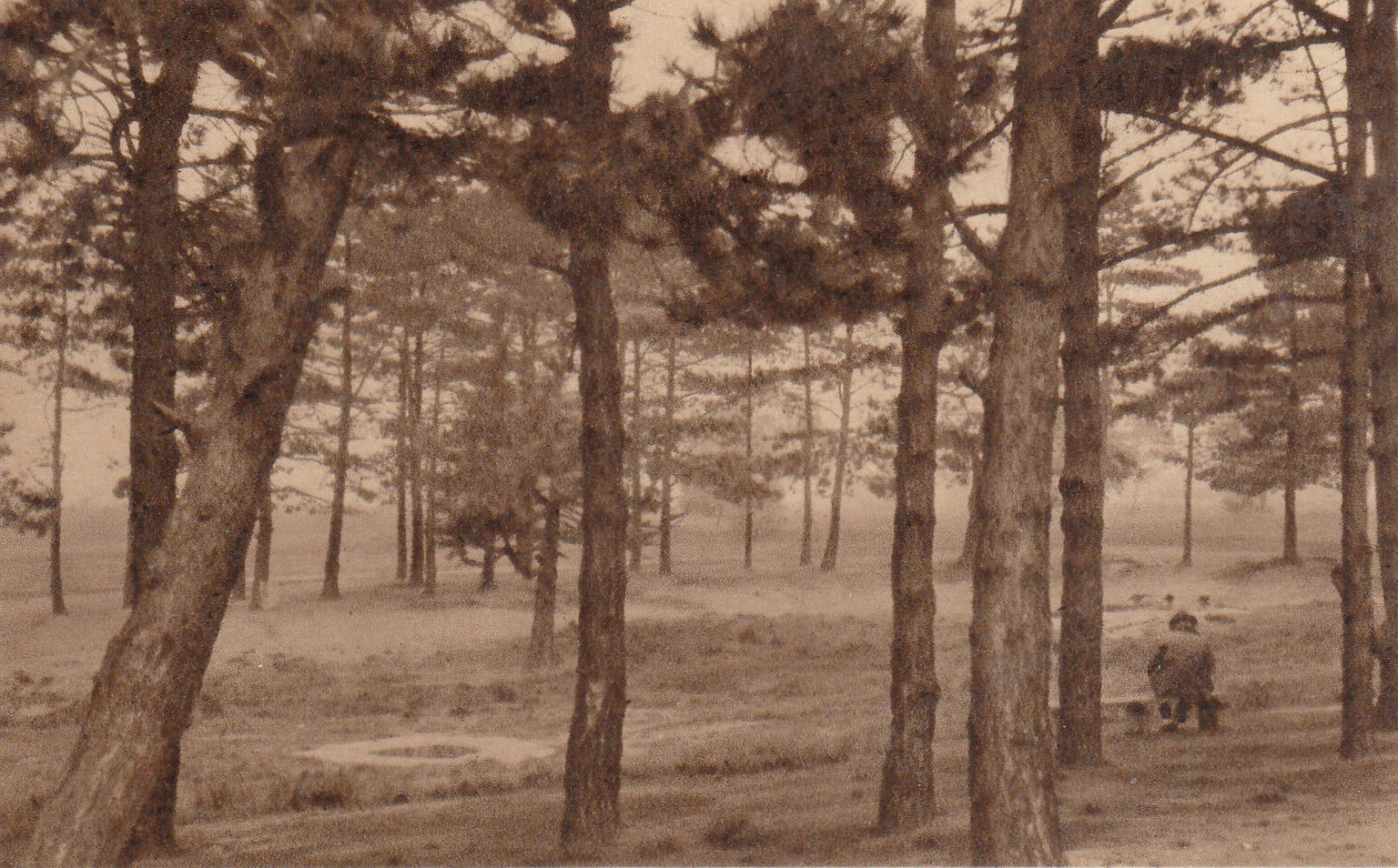
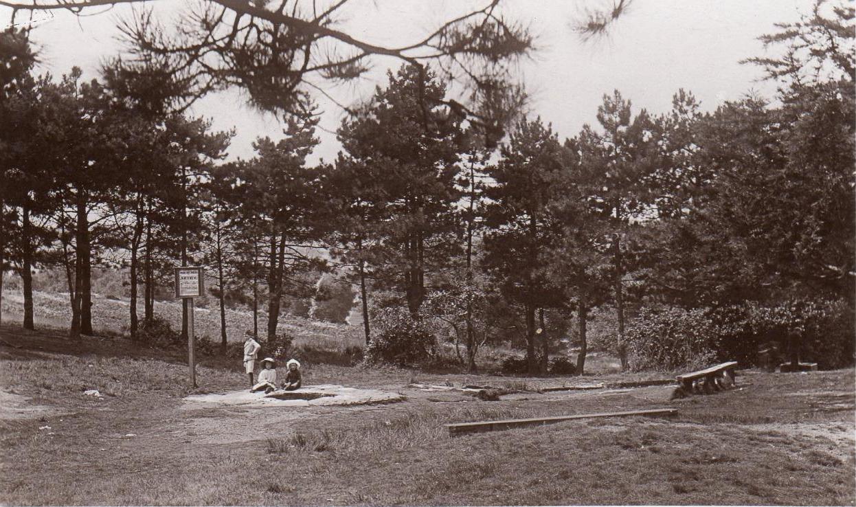
Caesar’s Well around 1900Caesar’s Well around 1911
“Caesar’s Well, formerly known as Robin Hood or Roman Well—the Springpond Well on the Ordnance Map—issues on the other side of the little watershed above mentioned, at a height of 149 feet O.D. The well lies in a little hollow, now ringed with Scottish pines. The gathering ground is the land to the east, rising to 198 feet O.D. This area is not large, but quite sufficient to maintain a permanent rill of pure water. The well, the waters of which once were deemed of special medicinal merit, was enclosed with brick in 1829, and, as the inscription tells us, refaced with granite blocks by Sir Henry W. Peek, M.P., in 1872. The outflowing waters descend to Brickfield Cottage, where they expand into a turbid duckpond; thence the course is through the yard behind the house, and along the north side of Robin Hood Road to Brook Cottage. During 1911 the “Well” proper altogether dried up, but water still issued from the stand spout a few yards below, which is supplied by an artificial boring and pipe that tap the spring at a depth of 18 feet.”
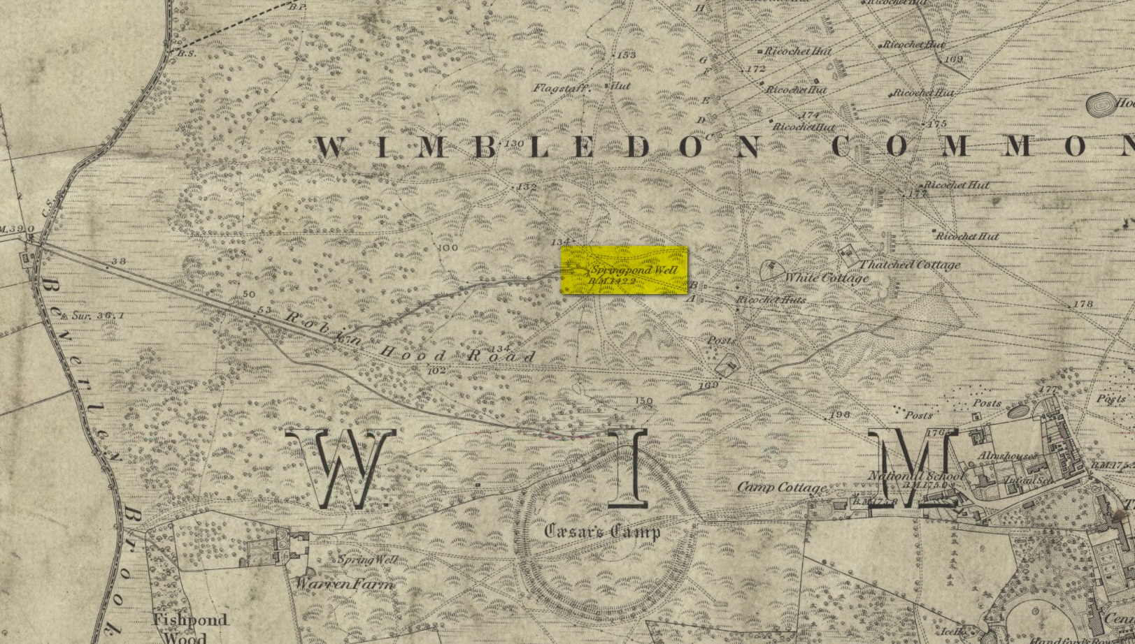
Site shown on the 1874 map
The proximity of this never-failing spring to the huge prehistoric enclosure of Caesar’s Camp just a few hundred yards to the south would indicate it was an important water source in Bronze Age times and, I’d hazard, would have been bestowed with some sanctity, as many such wells tended to be.
Folklore
James Rattue (2008) informed us that the name Robin Hood’s Well was known here in the 18th century prior to it being known as Caesar’s Well, but there seems to be no known relationship between Robin Hood and this site. However, a piece written in 1922 told that there was a lingering tradition that Julius Caesar encamped on Wimbledon Common in 51 BCE and that this folk memory was kept alive in the lore of local children who devoutly believed that the great Roman Emperor drank from the cool depths of this well.
References:
Bartlett, William A., The History and Antiquities of the Parish of Wimbledon, Simpkin Marsall: London 1865.
Hughes, John L., “Caesar’s Well, Wimbledon Common,” in Source magazine, no.9, Spring 1989.
Johnson, Walter, Wimbledon Common – Its Geology, Antiquities and Natural History, T.Fisher Unwin: London 1912.
Rattue, James, Holy Wells of Surrey, Umbra: Weybridge 2008.
Cup-and-Ring Stone: OS Grid Reference – NS 8551 8819
Archaeology & History
Looking down on C-7c
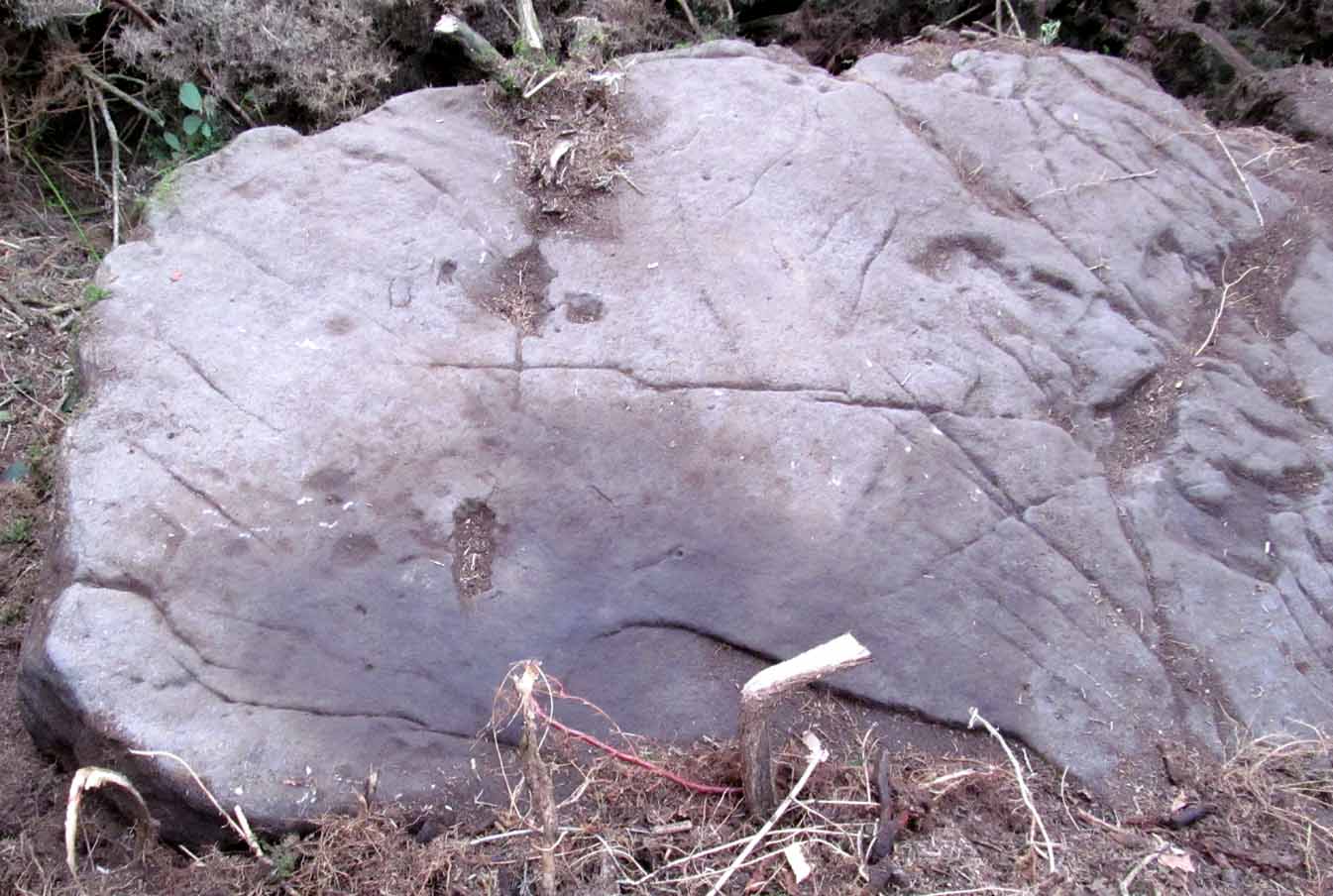
Near the northwestern end of the small geological ridge that runs to the west of Castleton farmhouse, close to an awesome nine-ringed carving, we find this more simplified triple-ringed petroglyph. And although the carving is easy enough to describe, its labelling (as ‘Castleton 7c’) is rather troublesome. As with other carvings in this locale, the name of the stone is based on a survey done by Maarten van Hoek in the mid-1990s. But van Hoek’s sketch of Castleton 7c and the one shown in our photos, whilst very similar, possess attributes that aren’t on van Hoek’s drawing. Now this isn’t too odd, as many petroglyphs look different when lighting conditions change; to the point where some features you can see one day are almost invisible the next. But this carving has attributes that are very difficult to miss – and van Hoek’s detailing tended to be good. But, all this aside: until we can verify with certainty one way or the other and despite my suspicions that this isn’t what van Hoek described, I’m still entering this carving as Castleton 7c. So – now that bit’s out of the way…!
When we visited the site two years ago the day was dark and overcast, so we didn’t really have good conditions for seeing any faint carvings. But this wasn’t faint, thankfully. It was completely buried beneath soil and gorse bushes, but thankfully Paul Hornby managed to unearth the one you can see in the photos. If it is the Castleton 7c petroglyph, it was rediscovered by van Hoek on one of his ventures here in 1985.
Carving showing wavy lines on right…and from another angle
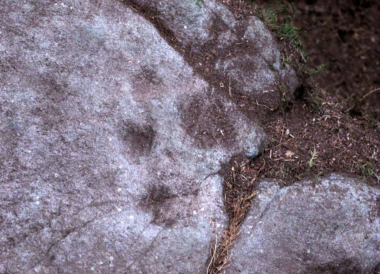
When we visited the site we only managed to uncover a small section of the stone, as the roots of the surrounding gorse prevented us from seeing more. (it’s tough stuff unless you’ve got the right gardening equipment!) The section we uncovered consisted of a cup-and-triple-ring. This is consistent with van Hoek’s sketch and description; but we also found there were two very notable ‘arcs’ on the outer edge of the rings—nearly opposite each other—as if another, fourth ring had been started. You can’t really miss these elements – and even in the poor lighting conditions we had, these outer arcs are very evident on a number of photos – especially when they are expanded to full-scale. However, as I mentioned, we were unable to uncover all the rock; but when van Hoek was here there was far less herbage. What he saw on this carving was as follows:
“Deturfing part of this ridge revealed a fine cup with three rings with a broadly pecked tail; one solo cup; one large oval ring with small central cup; and a faint cup with two rings, the outer one incomplete. The rock slopes 12º ENE.”
Crap drawing done in crap lightingvan Hoek’s 1996 sketch
The “broadly pecked tail” he mentions is also not really clear in any of the 60 photos we took. There is a faint line that runs through the three rings, into the central cup and out the other side: a single curving line no less. It’s certainly visible, but it’s far from broad. But there are a number of other lines coming out of the rings. These maybe just natural scratch marks, or even scratches acquired from farming activity. It’s difficult to say. In the poor light that we had, there as looked to be a single cupmark a few inches away from the rings, but this isn’t consistent with the position of the cupmark on van Hoek’s sketch.
There’s a simple solution to all this: we need to revisit the site and expose more of the rock. At least that will tell us once and for all whether this is the same as van Hoek’s stone, or whether we’ve found yet another new carving. Watch this space, as they say! 😉
References:
van Hoek, Martin A.M., “Prehistoric Rock Art around Castleton Farm, Airth, Central Scotland,” in Forth Naturalist & Historian, volume 19, 1996.
As with other carvings in this locale, the name of the stone is based on a survey done by Maarten van Hoek. (1996) It’s a pretty simplistic design within the impressive Castleton complex, found at the southeastern end of the gorse-covered rocky ridge, about 70-80 yards west of the farmhouse. It was uncovered on a visit here by Nina Harris, Paul Hornby, Frank Mercer and Lisa Samson on Sunday 19 November, 2018.
The cup-marked stoneLarge cup & arc of 3
Unlike the others in the Castleton complex, this carving is probably of interest only to the hardcore petroglyph hunters. The design consists of at least ten cup-marks on the uncovered section of the rock, one of which appears to have a broken circle with two ‘entrances’ either side of it, so to speak. The most notable element in the design is close to the edge, where an arc of three cups almost corners a larger cup right at the edge. There may be more carved elements to be found on the westerly side of the stone, which was covered in deep vegetation when we came here.
References:
van Hoek, Martin A.M., “Prehistoric Rock Art around Castleton Farm, Airth, Central Scotland,” in Forth Naturalist & Historian, volume 19, 1996.
If you’re travelling from Stirling or Bannockburn, take the B9124 east to Cowie (and past it) for 3¾ miles (6km), turning left at the small crossroads; or if you’re coming from Airth, the same B9124 road west for just about 3 miles, turning right at the same minor crossroads up the long straight road. Drive to the dead-end of the road and park up, then walk back up the road 350 yards to the small copse of trees on your left. Therein, some 50 yards or so, zigzag about!
Archaeology & History
Petroglyphs can be troublesome things at the best of time: not only in their ever-elusive root meanings, but even their appearance is troublesome! This example to the east of Cowie in the incredible Castleton complex is one such case. It is undoubtedly a multi-period carving, probably first started in the neolithic period, added onto in the Bronze Age, and maybe even finished in the early christian period. You’ll see why!
It’s been described several times in the past, with Maarten van Hoek (1996) telling how it was rediscovered,
“by Mrs Margaret Morris in 1986 in the birch-coppice at Castleton Wood. A fragment of outcrop rock with a distinct cup-and-three-rings, rather oval-shaped like others in the area.”
The main cup-and-3-rings (photo, Paul Hornby)
But as our own team found out, there’s more to it than that. Like many of the Castleton carvings, vital elements have been missed in the previous archaeological assessments. But it’s an easy thing to do. The carved design here almost ebbs and flows with daylight, shadows, changes in weather, bringing out what aboriginal and traditional peoples have always told us about rock itself, i.e., it’s alive, with qualities and virtues that can and do befuddle even that great domain of ‘objectivity’—itself an emergent construct of an entirely subjective creature (humans). But that’s what petroglyphs do!—whether they are part of a living tradition, or lost in our striving modernity, exhibiting once more that implicit terrain of animism. And this carving exemplifies it very clearly.
The primary visual design is the odd triple-ring, which isn’t quite as clear-cut as the earlier descriptions would have you think. In the drawing below by van Hoek (1996), three complete elliptical ‘rings’ are shown; whereas on its northern edge where the outer ring is closest to the rock edge, we find that the ‘ring’ has carved lines that run off and down the slope of the stone towards ground-level. It also seems that from the inner second-ring, a natural scar in the rock has been heightened by pecking, creating an artificial carved line running from near the centre and ‘out’ of the three rings. You can make this out in the accompanying photo, above.
van Hoek’s 1996 sketchThe more complete design
Additionally we found two very faint carved ‘eyes’ or trapezoids pecked onto the stone, obviously at a much earlier date than the notable triple-ring—which could almost be modern! They would no doubt have excited the old archaeologist O.G.S. Crawford (1957), whose curious theory of petroglyphs was that they were images of some sort of Eye Goddess. Archaeo’s can come out with some strange ideas sometimes…
Fainter still was another triple-ring—albeit incomplete—with what appears to be a very small central cup-mark, just below and between the two ‘eyes’. It was first noticed by Paul Hornby when he was playing with the contrast settings on his camera, in the hope of getting clearer photos of any missing elements.
Very faint triple-ring, bottom-left of photo (photo by Paul Hornby)
“Can you see this?” he asked. And although very faint indeed (on most days you can’t see it at all), it’s undoubtedly there: another multiple-ringer all but lost by the erosion of countless centuries, and older still than the ‘eyes’ above it. In all the photos we took of this stone, from different angles in different weathers (about 100 in all), this very faint triple-ring can only be seen on a handful of images. But it’s definitely there and you can see it faintly in the attached image (right) to the bottom-left.
A final note has to be made of a possible unfinished, large circular section with a cross carved into the natural feature of the stone, first noticed by Lisa Samson. It’s uncertain whether this has been touched by human hands (are there any geologists reading?), but it’s something that we’re noticing increasingly at more and more petroglyph sites. They’re not common, but it has to be said that we found two more man-made ‘crosses’ attached to multiple cup-and-rings near Killin just a few weeks ago. Also, folklore tells us that not far from this Castleton cluster, a christian hermit once lived….
References:
Crawford, O.G.S., The Eye Goddess, Phoenix House: London 1957.
Morris, Ronald W.B., The Prehistoric Rock Art of Southern Scotland, BAR: Oxford 1981.
van Hoek, M.A.M.,”Prehistoric Rock Art around Castleton Farm, Airth,” in Forth Naturalist & Historian, volume 19, 1996.
Acknowledgements: Huge thanks as always to Nina Harris, Fraser & Lisa Harrick, Paul Hornby, Penny & Thea Sinclair, for their additional senses and input.
If you’re coming via Castleton Farm, at the back of the farm go through the gate on the right, by the corner of the field and walk along the line of the wall for 200 yards northwest until you approach the small copse of trees ahead of you. Just before the trees, instead, walk up the slope, SW, to the other small copse, and about 15 yards along the line of trees, go into them. Keep your eyes peeled on the upwards sloping ground where a gap in the greenery shows you the stone in question!
Archaeology & History
This is an odd one. Amidst the array of truly ancient and well-eroded multiple cup-and-ring stones in the incredible Castleton complex, this small design on the northeast slope away from the main cluster, has a distinctly different appearance about it when we compare it to the others along the ridge. It’s not been done by the same person or people who carved the more ornate designs close by. Indeed, it seems that it wasn’t even done at the same period but has a history that is much more recent.
The carving, as you can see in the photos, has a somewhat scruffy look about it when compared to the more usual designs. If it’s prehistoric, it has the hallmarks of being done by someone with rock art dyslexia! My own view is that it’s a pretty recent carving. It’s possible, perhaps, that it may have been executed by a medieval christian priest who lived a short distance to the east and whose cross markings are evident on at least one of the other cup-and-rings hereby. But the carving might be even more recent: perhaps 19th Century in origin. It just doesn’t have that air of authenticity about it, as any seasoned petroglyph officionado would tell you. And we have to bear in mind that this was the site of a quarry in the 18th and 19th century, so the carving might have been done at that time by one of the workers to mimic the very ancient and faded designs close by. Anyhow…
The design consists of two distinct and deeply carved rings around a central raised point, in which it looks as if someone started to create a cup-mark, but never finished the job! The same can be said of an third outer-ring, whose faint outline is clearly visible in decent light, but which was started but never finished. Make of it what you will. When we first found this carving in 2019, someone had been up and already peeled back the turf (“there were a group o’ folk,” the farmer told me), thankfully showing the carving in its crude glory. The Canmore website informs us that the stone was first unfurled by George Currie in 2006, who said that it was little more than “a ring surrounded by a central boss”—but there’s clearly more to it than that and I wonder if this is actually the same carving that Mr Currie found.
Note: The name of this and the other carvings in the Castleton complex need completely re-designating into an accurate order, as they’ve been defined and redefined by various authors and groups over the years, leaving them in a disorganized haphazard mess.
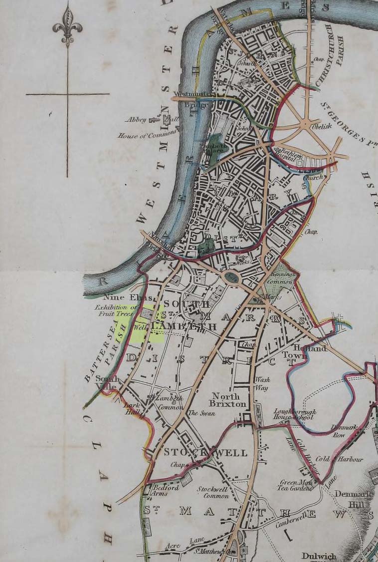
Healing Well (destroyed): OS Grid Reference — TQ 3006 7734
Archaeology & History
Site on 1824 map
In Thomas Allen’s (1827) huge survey of Lambeth parish, he told that there was little of any interest along Wandsworth Road, apart from a good orchard, “and a fine spring called Vauxhall Well.” According to Daniel Lysons (1792), it was located “not far from the turnpike”; and according to Mr Sunderland’s (1915), was to be found “on the right-hand side of the Wandsworth Road” as you walked down it to the south. Thankfully its position was highlighted on the 1824 map of the parish (right) that accompanied Mr Allen’s work.
It appears to have been built over in the latter-half of the 19th century, soon after William Thornbury (1878) wrote that he thought the well was still visible, but vanished soon after.
The waters were universally ascribed by all historians, from Mr Allen onwards, as being,
“esteemed highly serviceable in many disorders of the eyes, and in the hardest winter it is never known to freeze.”
The name ‘Vauxhall’ derives from that brilliantly famous family name of ‘Fawkes’ (as in Guy Fawkes), being the ‘hall of Fawkes’. The name was first recorded here as early as 1241. (Gover et al, 1934)