Small Wells, Louth, Lincolnshire

Sacred Wells (destroyed):  OS Grid Reference – TF 32603 87555

Also Known as:

  1. Little Wells

Archaeology & History

Small Well on 1834 map

Of the three wells in old Louth around which local ceremonies occurred, the Small Wells were apparently the least impressive.  Its ritualised compatriots south of the River Lud in St. Helen’s Well and the Ash Well (the Aswell in modern Louth place-names) were reportedly the much better water supplies in bygone times.  The site was highlighted on a map of the town in Robert Bayley’s (1834) history of the area, showing it as a small pool just below the Cistern Gate road; but when the Ordnance Survey lads came here later in the 19th century it had already gone.

It’s category here as a “sacred” well is due to it being annually decorated with garlands of flowers, commonly known today as well-dressing.  Such wells tend to be places of pre-christian rites, attended by local people at dawn usually at Beltane or at Midsummer (St John’s Eve); but I’ve been unable to find out which was the sacred day when the waters here were honoured.  All that we have left to tell us of the rites is from old township notes that said how,

““The small wells,” a cluster of little springs on the north of the town, shared in the honours of green boughs and popular huzzahs” the traditions held at the wells of St. Helen and Aswell a half-mile to the south.

A brief 16th century account told of a local man being paid for the adornment of the Small Wells: one “Henery Forman received for dressing small wells for a yeare – xiid” – or 12 pennies in old money.  Not bad at all in them days!

References:

  1. Bayley, Robert S., Notitiae Ludae; or Notices of Louth, W. Edwards 1834.

© Paul BennettThe Northern Antiquarian 

St. Trunnion’s Well, Barton-upon-Humber, Lincolnshire

Holy Well (destroyed):  OS Grid Reference – TA 026 223

Archaeology & History

This curiously-named, lost holy well was to be found somewhere between the old terrace at West Field and the old road of West Acridge, but even when Henry Ball (1856) wrote about it, the site had passed into history.  He told that,

“In the old enclosures to the west of the town was a spring of clear water called St. Trunnion’s well, and in a field in the West Acridge a very old thorn tree called St, Trunnion’s tree, which was standing in 1736; but who St. Trunnion was is not known…”

The close proximity of the tree with the well is highly likely.  Throughout the British Isles there are many relationships where sacred trees and wells of the same name are next to each other and we have little reason to doubt this was the case here.  However, unless local historians can uncover some old field-name maps, the exact location of the site seems to have been lost.  It was named as St Tronians in 1665; with his sacred tree mentioned in early enclosure awards dated 1681 and 1697 respectively.

The enigmatic saint ‘Trunnion’ is thought to derive, not from some old hermit or heathen holy dood, but from the corruption of an early word: “a perversion of Trin-union or Tri-union, used as an asservation or oath”; although another option cited by Cameron (1991) is that it derives from “trinune, trin-une, referring to the Trinity”—which would explain the sanctification of the waters.

References:

  1. Ball, Henry W., The Social History and Antiquities of Barton-upon-Humber, M. Ball: Barton-upon-Humber 1856.
  2. Cameron, Kenneth, The Place-Names of Lincolnshire – volume 2, EPNS: Nottingham 1991.

© Paul BennettThe Northern Antiquarian

St. Catharine’s Well, Barton-upon-Humber, Lincolnshire

Holy Well (destroyed):  OS Grid Reference – TA 032 222

Archaeology & History

Not far from the middle of this small town there lived, many centuries ago, a sacred spring of water dedicated to St. Catharine.  Described in local field-names from 1697 (as St. Catherin’s Well), all trace of it has long since vanished.  Indeed, even when Henry Ball (1856) wrote about it, local knowledge of it had already fallen into obscurity.  He could merely tell us that,

“At the end of Newport, in what was called “the Colony,” was St. Catharine’s Well, and the road from thence to Finkle lane was named Catharine street.”

Folklore

St Catharine’s festival date—known as Cattern Day in some parts of England—is November 25.

References:

  1. Ball, Henry W., The Social History and Antiquities of Barton-upon-Humber, M. Ball: Barton-upon-Humber 1856.
  2. Cameron, Kenneth, The Place-Names of Lincolnshire – volume 2, EPNS: Nottingham 1991.

© Paul BennettThe Northern Antiquarian

St. Pancras’ Well, Scampton, Lincolnshire

Holy Well (destroyed):  OS Grid reference – SK 9542 7853

Archaeology & History

Site shown on 1886 map

Mentioned in Thompson’s (1999) survey but without comment, it was, curiously, Skyring Walters’ (1928) that drew my attention to this site.  He added it to his list of St Pancras sites, telling how even in his day, it had fallen into memory.  Indeed, it had already gone when the Ordnance Survey lads came here in 1885.  Thankfully we were left with an albeit piecemeal account of the place by Cayley Illingworth (1810) before its destruction. It was an iron-bearing well that existed some fifty yards from an ancient Roman villa and was probably the water supply for the Romans who lived here.  He told us:

“The circumstance…of the chalybeate spring within a few yards from the entrance of the villa, and still called Saint Pancras Well…favours the conclusion of a chapel having been erected on its site.  (This) is supported by the strong evidence of a discovery, upon record, that a chapel dedicated to Saint Pancras did actually exist on this spot, so early as the beginning of the twelfth century; about which period Richard Fitz-Robert of Scampton gave to the monastery of Kirksted three selions of land in that lordship, two of which are described in the gift as lying in the south field, on the south side of the chapel of Saint Pancras.”

He further told that at the bottom of the well an oak floor had been laid, which had been dug up “several years ago.”

St Pancras’s festival date is April 3.

References:

  1. Cameron, Kenneth & Insley, John, The Place-Names of Lincolnshire – volume 7, English Place-Name Society: Nottingham 2010.
  2. Harte, Jeremy, English Holy Wells: A Sourcebook – volume 2, Heart of Albion Press: Loughborough 2008.
  3. Illingworth, Cayley, A Topographical Account of the Parish of Scampton in the County of Lincoln, T. Cadel & W. Davies: London 1810.
  4. Thompson, Ian, Lincolnshire Springs and Well, Bluestone: Scunthorpe 1999.
  5. Walters, R.C. S., The Ancient Wells, Springs and Holy Wells of Gloucestershire, St Stephens Press: Bristol 1928.

© Paul BennettThe Northern Antiquarian

St James’ Cross, Barton-upon-Humber, Lincolnshire

Cross (destroyed):  OS Grid reference – TA 0424 2064

Archaeology & History

This long lost wayside cross was described in various local records from 1621 upwards.  In the definitive place-name survey of this area, Kenneth Cameron (1991) told us that this was,

“A medieval cross dedicated to St James, situated at the point where the Thornton and Burnham roads meet… Mr R. Newton comments, “said to have replaced a wayside shrine.  The foundations of the shrine were exposed when the Home Guard dug a defensive trench there at the beginning of the last war.  Foundations destroyed by a bomb.””

References:

  1. Cameron, Kenneth, The Place-Names of Lincolnshire – volume 2, EPNS: Nottingham 1991.

© Paul BennettThe Northern Antiquarian

Devil’s Stone, Winceby, Lincolnshire

Legendary Rock (destroyed):  OS Grid Reference – TF 3127 6901

Also Known as:

  1. Big Stone of Slash Lane

Archaeology & History

Stone shown on 1887 map

There is no specific archaeological information about this stone.  However, we must take note of the so-called “devil’s footprint” that was on the boulder.  In some parts of the UK, some devilish and other mythic footprints on stone are prehistoric cup-markings; but we have no idea whether this impression was such a carving or—more probably in this case—Nature’s handiwork.  The field in which the stone existed was said to be the place where the so-called Battle of Winceby occurred.

Folklore

The stone was mentioned in several old tomes, with each one generally repeating the same familiar story, and with motifs that will be familiar to antiquarians and folklorists alike.  In an early edition of Notes & Queries we were told of,

“the large stone in Winceby field, where soldiers had sharpened their swords before the battle. This was a stone of fearful interest, for much treasure was supposed to have been buried under it. Numerous attempts have been made to get at this treasure, but they were always defeated by some accident or piece of bad luck. On the last occasion, by ‘yokkin’ several horses to chains fastened round the stone, they nearly succeeded in pulling it over, when, in his excitement, one of the men uttered an oath, and the devil instantly appeared, and stamped on it with his foot.  “Tha cheans all brok, tha osses fell, an’ tha stoan went back t’ its owd place solidder nur ivver; an’ if ya doan’t believe ya ma goa an’ look fur yer sen, an’ ya’ll see tha divvill’s fut mark like three kraws’ claws, a-top o’ tha stoan.’  It was firmly believed the lane was haunted, and that loud groans were often heard there.”

The tale was retold in Grange & Hudson’s (1891) essay on regional folklore.  In Mr Walter’s (1904) excellent local history survey, there was an additional shape-shifting element to the story which, in more northern climes, is usually attributed to hare; but this was slightly different.  The stone, as we’ve heard,

“was supposed to cover hidden treasure, and various attempts were made at different times to remove it, sometimes with six or even eight horses. At one of these attempts, his Satanic Majesty, having been invoked by the local title of ‘Old Lad’ appeared, it is said, in person, where upon the stone fell back, upsetting the horses.  On another occasion a black mouse, probably the same Being incarnate in another form…ran over the gearing of the horses, with a similar result.  Eventually, as a last resort, to break the spell, the boulder was buried, and now no trace of the boulder, black mouse, or Satan’s foot-print remains.”

Sadly we have no sketches of the devil’s ‘footprint’; and if local lore is right, we’ll never know.  For tis said that a local farmer in the 1970s dug down and removed the stone completely.  All that he found were numerous broken ploughshares around the rock, indicating that many tools had been used to shift the stone.

References:

  1. Grange, Ernest L. & Hudson, J.C. (eds.), Lincolnshire Notes and Queries – volume 2, W.K. Morton: Horncastle 1891.
  2. Gutch, Mrs & Peacock, Mabel, Examples of Printed Folklore Concerning Lincolnshire, David Nutt: London 1908.
  3. Walter, J. Conway, Records, Historical and Antiquarian of Parishes around Horncastle, W.K. Morton: Horncastle 1904.

© Paul BennettThe Northern Antiquarian


Holy Well, Somersby, Lincolnshire

Holy Well:  OS Grid Reference – TF 3417 7303

Also Known as:

  1. Halliwell

Archaeology & History

Holy Well on 1887 map

Curiously missing from Thompson’s (1999) Lincolnshire survey, this old watering place can apparently still be found in the appropriately named Holywell Wood, just north of this lovely little hamlet.  Shown on the 1887 OS-map of the area, it’s first literary reference seems to be in George Weir’s (1820) early survey of Horncastle district where he gives it a brief mention, saying:

“In a woody dell in this parish is a spring, gently bursting from the rock, called Holy-well, but the name of the saint to whom it was dedicated is not preserved.”

…Like oh so many others.  But its ‘holiness’ may devive from other more archaic origins, in the spirit of the woods from whence the waters emerge.  Certainly that’s what the poet laureate Alfred Lord Tennyson would have had us believe.  He grew up in Somersby village and this old well was one of his places of inspiration.  When the local writer H.D. Rawnsley (1900) described Tennyson’s affection for this site, he told us that,

“Alfred peopled that Holywell Wood with forms of fairies, and made the whole surrounding circle of the hills, a theatre for enchantment and chivalry.”

J.C. Walters 1890 sketch

Nature can certainly do that to anyone who wanders Her body with open reverence.

Although the place is now quite overgrown, it wasn’t always this way.  There used to be a well-trodden path with a gateway at the entrance that took you into the woods and up to the well.  Above the gateway there used to be a Latin inscription that read, Intus aquae dulces, vivoque sedilia saxo, Et paulum silvae superest. His utere mecum. (meaning something akin to, “At these sweet waters, by this living seat of stone and small forest remains, Make use of me.”)

When J.C. Walters wrote about it, he told that a “local student” gave him the following particulars:

“A series of steps led down into the well, a post was fixed in front of it, and a cross-bar extended thence to the rock.  On the cross-bar was a ring with a rope attached, so that the bather might safely descend into the well and enjoy the healing virtues of the stream which rushed from the rock.  Geologists say that the wold villages are so closely placed on account of the superior quality of the water which springs up wherever the Spilsby sandstone meets the Kimmeridge clay.  Susan Epton (Mrs. Thompson), Miss Emily Tennyson’s maid, tells me that she can remember the time when visitors came in scores to “take the waters.””

Some of this was later echoed in Rawnsley’s (1900) biographical account of Tennyson.  He talked with a local sexton about the folklore of the area who told him of his memories:

“Halliwell wasn’t growed up then; there was a bath-house with steps down to the watter, and fwoaks in carriages came from far and near to drink it.  Wonderful watter! it was nobbut a bit sen, that our owd nebbur was liggin’ adying and he axed for a cup o’ watter from the Holy Well, and they sent and fetched it, and he took it and went off upon his feet.  Why, i’ my time theer was a school-house down in Halliwell Wood, and a skittle halley close by the well, but all them things is changed now, excep the snowdrops, and they coomes oop reg’lar, a sight on ’em i’ Halliwell.”

References:

  1. Harte, Jeremy, English Holy Wells – volume 2, Heart of Albion Press: Wymeswold 2008.
  2. Howitt, William, Homes and Haunts of the Most Eminent British Poets – volume 2, Richard Bentley: London 1849.
  3. Rawnsley, H.D., Memories of the Tennysons, James MacLehose: Glasgow 1900.
  4. Thompson, Ian, Lincolnshire Springs and Wells, Bluestone: Scunthorpe 1999.
  5. Walter, J. Conway, Records of Woodhall Spa and Neighbourhood, W.K. Morton: Horncastle 1899.
  6. Walters, John Cuming, In Tennyson Land, George Redway: London 1890.
  7. Weir, George, Historical and Descriptive Sketches of the Town and Soke of Horncastle, Sherwood, Neely & Jones 1820.

© Paul BennettThe Northern Antiquarian


St. Helen’s Well, Hemswell, Lincolnshire

Holy Well:  OS Grid Reference – SK 932 911

Also Known as:

  1. Seven Springs

Getting Here

From the village lane at the east end of Brook Street, take the footpath through the first gate and then over the stile into the woods on your left (north).  Soon a clearing will appear on the left hand side as you climb the hill.  Careful as you scramble down (look for a swing set up by local children) on the left hand side will be the Devil’s Pulpit.

Archaeology & History

The village name deriving from ‘Helmes’, the genitive singjular of the Old English masculine name Helm, or from helmes, the genitive singular of OE helm ‘a helmet, the summit of a hill, a shelter’, so that the name is either ‘Helm’s spring’ or ‘spring at the summit or shelter’—which does rather neatly defines its topography.  However, other authorities suggest its gets its name from elm trees which once grew around the wells.

The site has an eerie but not unquiet atmosphere this is possibly due to the stone called the Devil’s Pulpit, a large approximately six-foot high piece of sandstone under which a small spring arises.

Folklore

This Thompson (1999) in his Lincolnshire Wells and Springs notes local opinion thought was St. Helen’s, he said it tasted sweeten than the other waters (a fact that I cannot testify as the spring has appeared to have almost dried up the year I went).  Binnall (1845) notes that the spring wells were regarded as possessing curative powers and rags were hung on the surrounding bushes.

The dedication of St Helen is an interesting one and can be seen as an outlier from those found widely distributed in Yorkshire (Whelan & Taylor, 1989), but rare in the adjoining counties of  Derbyshire and Nottinghamshire.  Harte (2008) in his English Holy Wells suggests that the name is spurious; and Rudkin’s (1936) Lincolnshire Folklore does not refer to it as such.  However, in support of the view, I had no problem locally detecting the well using this name in the village (incidentally Harte makes an error referring to the springs as Aisthorpe Springs, these are clearly another site).  There was supposed to be a chapel or church associated with the site, of which there is no trace or record.

Taken from R. B. Parish (2012) Holy Wells and healing springs of Lincolnshire

References:

  1. Cameron, Kenneth, The Place-Names of Lincolnshire – volume 6, EPNS: Nottingham 2001.
  2. Harte, Jeremy, English Holy Wells, Heart of Albion: Loughborough 2008.
  3. o’ Neill, Susanna, Folklore of Lincolnshire, History Press: Stroud 2012.
  4. Rudkin, Ethel, Lincolnshire Folklore, 1936.
  5. Thompson, Ian, Lincolnshire Springs and Wells: A Descriptive Catalogue, Bluestone: Scunthorpe 1999.
  6. Whelan, Edna & Taylor, Ian, Yorkshire Holy Wells and Sacred Springs, Northern Lights: Dunnington 1989.

Links:

  1. Holy & Healing Wells

© R.B. Parish, The Northern Antiquarian


Ragged Spring, Healing, Lincolnshire

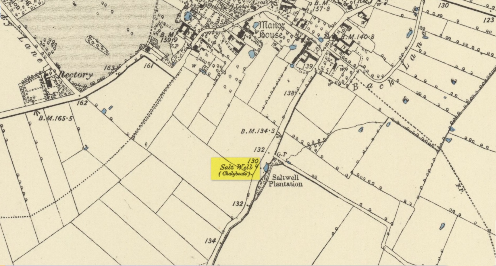
Healing Well:  OS Grid Reference — TA 199 096

Also Known as:

  1.  Ragged Well

Getting Here

The site can be found along Wells road, just after the turning for Healing wells farm and after the mirror.  One may need to beat through the thickets to reach it.

Archaeology & History

The Ragged Spring

The Ragged Spring

Some confusion exists over the relationship between the wells and the parish name. This is possibly an ancient site, as the earliest name for the parish is ‘Heghelinge’ and perhaps derive from the springs.  However, this is at variance to the view of Kenneth Cameron (1997) in his Place-Names of Lincolnshire, where it is noted that ‘Hægelingas’ is derived from “the sons or followers of a man named Hægel” rather than healing, although it is of course a strange coincidence!

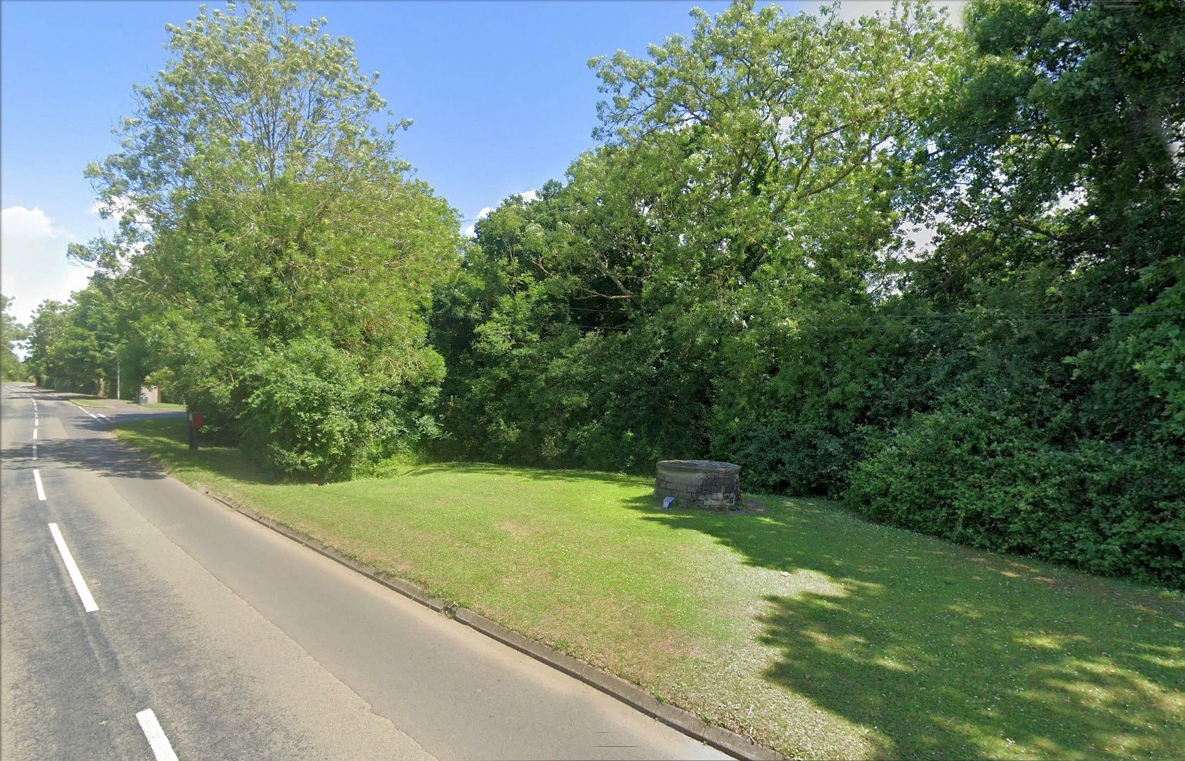
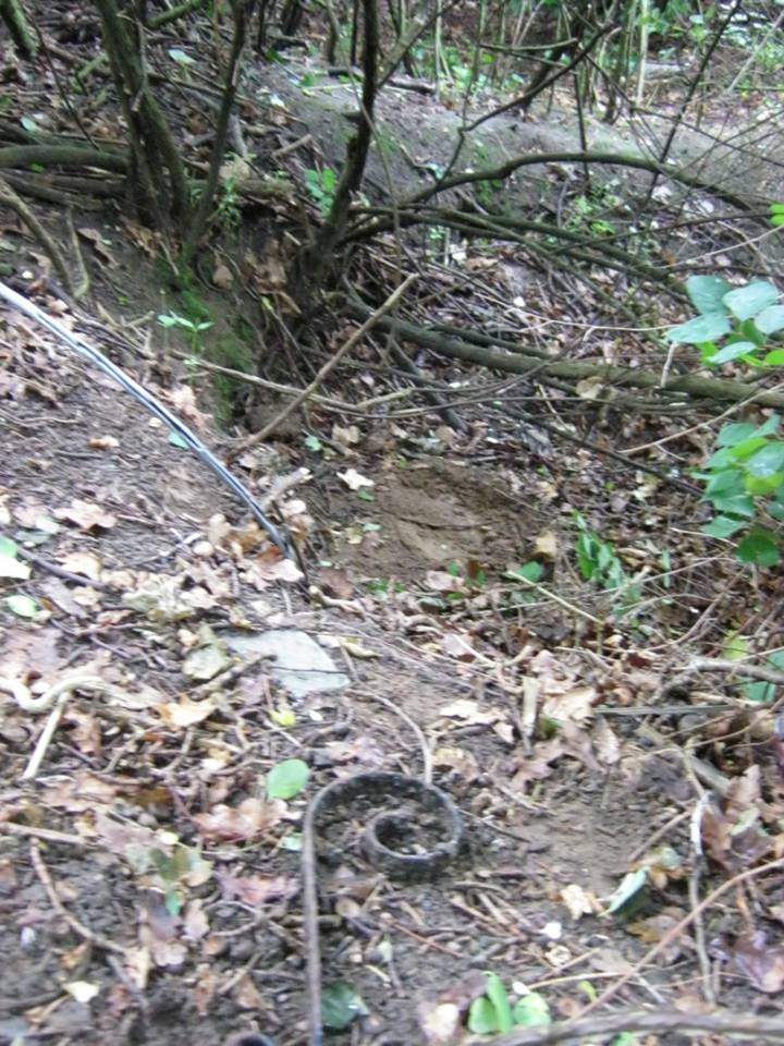
The springs are still marked on the current OS map, as Healing Wells, in a small plantation, but they are, as the photo shows, only marked by circular indentations in the ground.  The first spring is the easier one to trace and it appears to have holes, although these may be made by animals.  The springs are now quite dry, perhaps that the clogging of the springs noted above continued as the waters were forgotten, resulting in the current situation. There is no clear lining around the well or other structures. Lying around the springs are a range of metal buckets in various stages of decay and some metal pieces which may be remains of a metal fence around it. Sadly, I was unable to find any sign of rags although the man I asked in the whereabouts referred to them as “the ragged springs.”

Folklore

The Ragged Springs fed a stream where people paddled or hung garments on bushes to acquire good health strangely rather than the wells themselves. Gutch and Peacock  (1908) in their County Folklore note that a,

“Mr. Cordeaux visited them not long since for the purpose of discovering whether pins are ever dropped into them, but the bottom of the water in both cases was too muddy and full of leaves to allow accurate examination.”

According to Gutch and Peacock (1908) each well had a different use, one spring being a chalybeate one was done for eye problems, whereas the other was for skin problems. They continue to note that a:

F S, a middle-aged man, who grew up in an adjoining parish, states that when he was a lad, one spring was used for bathing, and the second for drinking. The latter was considered good against consumption, among other forms of sickness. . . . What the special gift of the bathing well was F S cannot say. He often plunged his feet into it when a boy, but he does not venture to assert that it had any great power in reality, although ‘folks used to come for miles,’ and the gipsies, who called the place Ragged Spring or Ragged Well, frequently visited it. A Gentleman who hunts with the Yarborough pack every winter, says that he notices the rags fluttering on the shrubs and briars each season as he rides past. There is always a supply of these tatters, whether used superstitiously or not, and always has been since his father first knew the district some seventy years ago.”

This would appear to be the site recorded as below under Great Cotes by R.C. Hope (1893) in his Legendary Lore of Holy Wells:

“there is a spring celebrated locally for its healing properties. It rises from the side of a bank in a plantation, and is overshadowed by an ancient thorn, on the branches of which hang innumerable rags, fastened there by those who have drunk it waters.”

The custom apparently continued until the 1940s.  Indeed a visitor in the 1920s noted that even the trunks were covered with longer pieces of rag.  A picture in the 1995 edition of Lincolnshire Past and Present journal shows a number of rags on the bushes. It is worth noting that perhaps the presence of a large thorn perhaps suggests a great antiquity to the site.

References:

  1. Cameron, Kenneth, The Place-Names of Lincolnshire – volume 5, EPNS: Nottingham 1997.
  2. Gutch, Mrs & Peacock, Mabel, County Folk-lore – volume v: Examples of Printed Folk-lore Concerning Lincolnshire, David Nutt: Folk-lore Society 1908.
  3. Hope, Robert Charles, Legendary Lore of the Holy Wells of England, Elliott Stock: London 1893.
  4. Parish, R.B., Holy Wells and Healing Springs of Lincolnshire. Pixyled Publications 2013

Links:

  1. Holy & Healing Wells

© R.B. Parish, The Northern Antiquarian


Maypole, Hemswell, Lincolnshire

Maypole: OS Grid Reference – SK 92954 90947

Historic photo from Church Street

Also Known as:

  1. English Heritage ID: 196736

Getting Here

In Hemswell Village at the junction of Church Street and Maypole Street.

History & Archeaology

According to a 2010 report in the Scunthorpe Telegraph, the Hemswell villagers,

“claim to be the hosts to one of the oldest maypole celebrations in the world, dating back to at least 1660”.

The then clerk to the parish council, Dianne Millward is quoted as saying:

“Hemswell is widely regarded in historical circles as having one of the oldest if not the oldest celebrations for May Day. We have pictures of the pole being prepared for the big day in the very early 1900s.”

Hemswell maypole on 1906 map

This writer has not yet been able to independently verify these claims.

May Day is still celebrated in the village with dancing around the maypole and an accompanying fete. Recent online photographs show that it is now only children, in ‘historic’ fancy dress who ribbon-dance around the Pole.

© Paul T. Hornby 2016 The Northern Antiquarian