Cup-Marked Stone (lost): OS Grid Reference – NO 262 503
Archaeology & History
In an excursion to the Iron Age Hillfort on Barry Hill in the early 1960s by some members of the Perthshire Society of Natural Science, near the very top on its southwestern side they discovered “a small cup marked stone.” (Longworth 1962) It hasn’t been seen since. And whether it was in the walling of the fort, or was a carved earthfast rock, they neglected to tell. When I visited here several years ago I couldn’t find the damn thing and presume that it’s simply been overgrown by the vegetation. In the event that you manage to rediscover the carving, see if you can catch us a good photo or two and stick ’em on our Facebook group.
References:
Longworth, Ian, “Dundee, Angus,” in Discovery & Excavation, Scotland, 1962.
Stone Circle (destroyed): OS Grid Reference – NO 220 416
Archaeology & History
In the first volume of the Royal Society’s Committee on Boulders (yes, there was such a thing!) that was read in April 1872, a megalithic ring was described that stood on the north side of the River Isla, above Coupar Angus. It was told that the minister of Bendochy, Dr Barty, reported to the committee, that
“on the rising ground behind his manse, there was a circle of large stones, boulders, standing on their ends (Druidical); but some years ago they were removed. The place is yet called ‘The Nine Stanes.'”
Despite its destruction, in recent times aerial photography has identified a number of features in the field above the manse, including what seems to be an enclosure and some disc-shaped cropmarks. One of these may be the shadow marks of the circle.
References:
Home, David Milne, First Report by the Committee on Boulders, Royal Society Edinburgh 1872.
Cup-Marked Stone (lost): OS Grid Reference – NO 074 458
Archaeology & History
In J. Romilly Allen’s (1882) lengthy essay on rock art in Scotland, he mentions a singular boulder that was “found by Dr Rattray” at Laighwood, near Butterstone—but, unlike him, he gave no further details regarding its appearance or exact whereabouts. It was included in the Royal Commission (1990) survey of the area, with no additional details. It remains lost. In the event that you manage to rediscover it, grab some good photos of it and stick ’em on our Facebook group. (the grid-reference to this site is an approximation)
Royal Commission on the Ancient & Historical Monuments of Scotland, North-East Perth: An Archaeological Landscape, HMSO: Edinburgh 1990.
Acknowledgements:Huge thanks for use of the Ordnance Survey map in this site profile, reproduced with the kind permission of the National Library of Scotland.
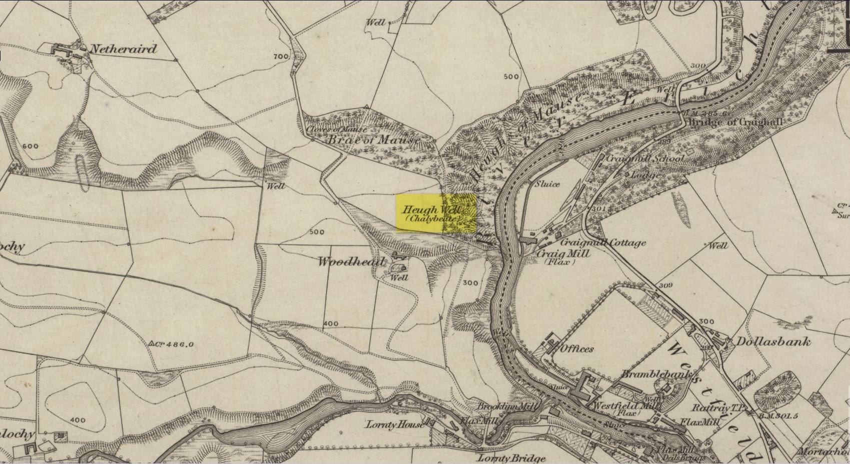
This little-known iron-bearing spring can still be found in the woodland known today as the Heugh of Mawse, a mile north of Blairgowrie. It was included in the Object Name Book of 1863, where they referred to an earlier account in the New Statistical Account, which told that,
“On the south end of it is a chalybeate spring much resorted to by the people of the locality. “There are one or two chalybeate springs in the parish; but they have never been chemically analyzed. There is one very fine spring called the “Heugh Well” It springs from the face of the “Heughs of Mause” (a mortar cliff of singular appearance; which descends abruptly into the bed of the river with an almost perpendicular declivity of about 200 feet) and judging from its colour, contains a considerable quantity of ferruginous matter. The use of its water has been found to be very beneficial in cutaneous eruptions, & affections of the Stomach.””
Heugh Well on 1867 map
Subsequently highlighted on the 1867 OS-map, a singular footpath led to the site and no further. It was mentioned by the regional historians J.G. McPherson (1885) and John MacDonald (1899), albeit briefly, where they respectively told that its waters were “formerly much resorted to by persons in the neighbourhood.” It possessed considerable medicinal properties which, according to tradition, were “found very beneficial for skin diseases and derangement of the stomach”! Doubtless such attributes will still be effective.
Holy Well (destroyed): OS Grid Reference – NO 180 452
Archaeology & History
The Well Meadow in the middle of Blairgowrie was once the place where the 5th century Apostle of the Southern Picts, or St Ninian, baptised local folk into the so-called “new faith”. It’s long since gone. The local historian John MacDonald (1899) told that it was located opposite the buildings on the north-side of the square, adding:
“St Ninian, one of the earliest Christian Celtic missionaries, on his tour through Scotland, pitched his camp where the Wellmeadow now is, and quenched his thirst at an old well or spring which ever afterwards bore the name of “St Ninian’s Well,” until it was covered in and the water led into the town drains.”
Cup-Marked Stone (lost): OS Grid Reference – NO 186 480
Archaeology & History
When J. Romilly Allen (1881) wrote about the megaliths and petroglyphs of Glenballoch, the owner of the property—a Mr George Harris—informed him of other archaeological finds in the locale: one of which was a cup-marked stone with distinct linear elements, whose description reminded me, slightly, of Ilkley’s Idol Stone. It was found a short distance east of the Glenballoch (or Craighall Mill) stone circle. Allen told how,
“Mr Harris…informed me that about twenty years ago he had dug up a stone with cup-markings upon it, on the opposite side of the valley to the south-east of the Glenballoch stone. The stone lay horizontally with the cups uppermost. It was split up and is now built into the out buildings of Glenballoch Farm. The two largest fragments form the cover and sill of the hole through which the shaft of the threshing machine passes through the wall of the horse-mill, into the house. A third fragment is built in above the window at the opposite side of the house, and is of greenish hue. Mr Harris expressed his great regret at not having known the value of this stone when he broke it up, and he is evidently proud of the stone which remains, and is determined that no ill shall befall it as long as he remains its guardian. The cup marks on the stone which was broken appear to have been arranged symmetrically in two rows, and Mr Harris affirms distinctly that they were alternately circular and rectangular.”
These three stone fragments have not been seen since. They may still be covered over in the spot Mr Harris described, but no one seems to have found them. In the event that someone manages to find them, see if you can get a few good photos and stick ’em on our Facebook group.
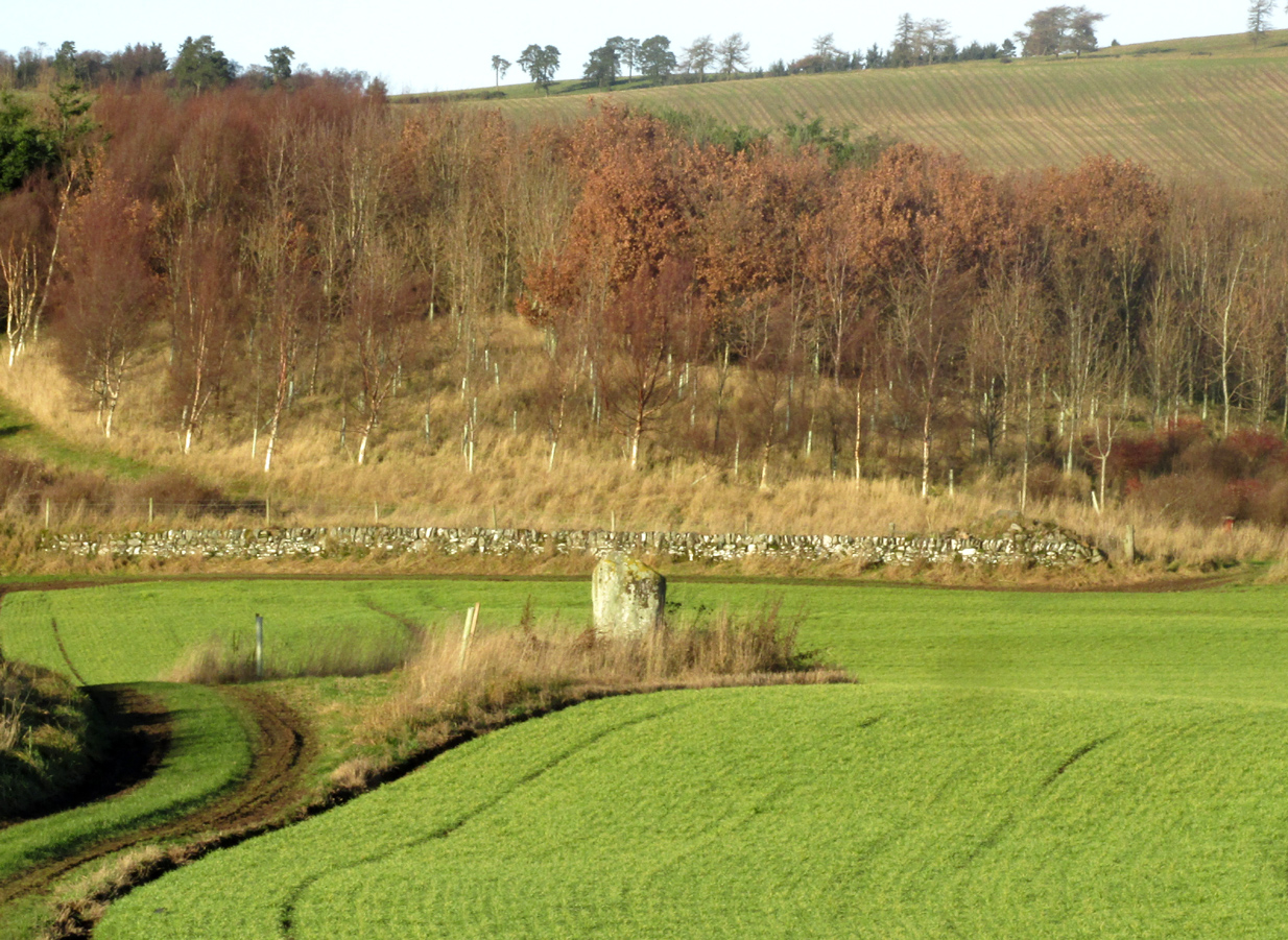
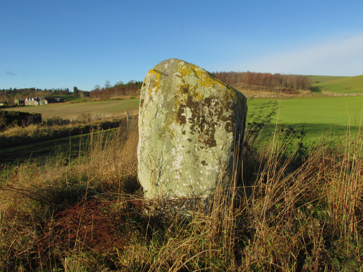
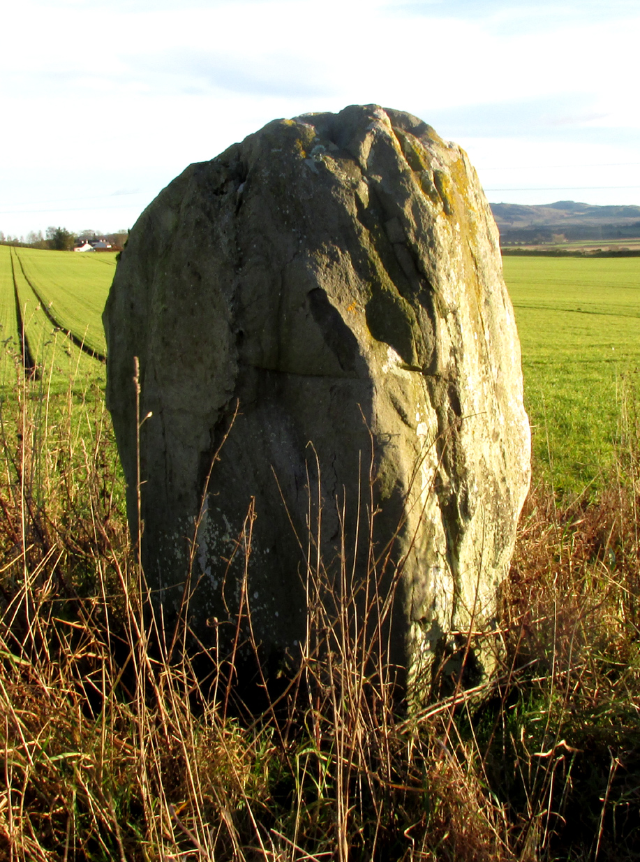
Just less than a mile east of Blairgowrie, the site is situated about 200 yards along a farm track that runs north from the A926 Rattray – Alyth Road. This road is narrow with a lot of bends and very busy, with no safe parking places. It is best to walk from Rattray, the stone will be seen in the field just east of Drumend Farm.
Archaeology & History
There is one stone here that survives from a megalithic ring that was progressively destroyed some time between the publication of the 1792 Old Statistical Account and the publication of the 1867 OS map. Reverend James Smith, writing in the 1792 Statistical Account, told us:
“Above the river, SE from the village, in a beautiful situation, is a Druidical temple, much defaced, and many of the stones carried off. The farm upon which it has been built, is called Standing Stones.”
Reverend William Herdman wrote patronisingly in the 1845 New Statistical Account:
“If large graystones be entitled to the appellation of antiquities, or are any indication of the religious worship of our ancestors, a few of these appear in a field, thence called Standing Stanes, which are supposed to be the ruins of a Druidical Temple.”
Many years later, in the first few years of the 20th century, the great northern antiquarian and megalith writer, Fred Coles, visited the site and gave this description in 1909:
“Standing Stone on the Farm of Standing Stone, Old Rattray. [A] monolith attracts our notice, in a field on the north of the main road, one mile and a quarter east of the middle of Old Rattray village. The height above sea-level is 270 feet. This monolith …[has a] mineralogical composition …more analogous to the quartziferous schists so frequently found in the vicinity.
The top is smooth, with an inclination towards the south-east, and the whole mass is squarish and pillar-like. It is set up with the longer axis N.E. 50° and S.W. 50°. The highest point is 5 feet 1 inch above ground, the basal girth 8 feet, but rather more than mid-way up it increases to 10 feet 4 inches.
In this lower-lying district, comprising an area of about 35 square miles, the megalithic remains are extremely sparse. Agricultural operations, doubtless, have swept away some monoliths, and possibly also whole circles of stones; but at any rate it is somewhat significant that only four Standing Stones are now left, and that there is no record on the maps of any other variety of sepulchral structure.”
This brave survivor has a commanding position over the valley of the River Ericht, and again we can only lament the loss of its companions, but be thankful it too didn’t fall prey to ‘agricultural improvements’ or religious bigotry.
References:
Smith, Rev.James, Old Statistical Account, Perthshire, Parish of Rattray, 1792. #
Herdman, Rev. William, New Statistical Account, Perthshire, Parish of Rattray, 1845.
Coles F.R., ‘Report on stone circles surveyed in Perthshire (South-East District), with measured plans and drawings; obtained under the Gunning Fellowship’, Proc. Soc. Antiq. Scot., vol. 43, 1908-9.
Cup-and Ring Stone (destroyed): OS Grid Reference – NO 143 430
Archaeology & History
In John MacDonald’s History of Blairgowrie (1899), he describes a number of the prehistoric sites in the neighbourhood, including the cup-marked standing stone at nearby Glenballoch. However, one petroglyph that seems to have escaped the attention of all previous surveys was, “one unearthed in 1897 at Aikenhead,” southeast of Blairgowrie. Mr MacDonald described it as possessing “a large number” of cup markings “of various sizes.” But even in his day he reported that the carving had, “unfortunately, been destroyed.”
I can find no other references to this site. Is anyone aware of any, or know anything more about this lost stone?
References:
MacDonald, John A.R., The History of Blairgowrie, Advertiser: Blairgowrie 1899.