Standing Stone (destroyed): OS Grid Reference – NT 074 698
Archaeology & History
A few hundred yards west of the commemorative Wallace Stone monolith could once be seen a standing stone of considerable size. It was described by James Primrose (1898) in his description of the standing stones of the Strathbrock region; but even in his day, remains of it were fragmentary. He wrote:
“On Drumshoreland Moor, within the grounds of Pumpherston Oil Company, there is a stone, popularly styled Bucksides — its correct designation being Backsides — from its position at the backside of Pumpherston. This stone, a huge whinstone boulder about 12 feet long and 8 feet broad, was blasted in 1888, to make room for the site of a bench of retorts; a few fragments of the stone, however, yet remain by the roadside. The ancient name of this stone was Ballengeich — apparently the Gaelic for “the township towards the wind”, — as if a croft once stood here, near Pumpherston Mains, in an exposed and windy situation.”
A visit to the local history department of the local library might prove fruitful in giving us more information about this place—that’s assuming the filthy tory central government’s theft of taxpayer’s money doesn’t close it! (does that sound a bit harsh? 😁 )
Folklore
The same historian told of a “tradition…that round this stone in days gone by the Broxburn folks, along with their neighbours, used to assemble at Fair time, in the month of August, in order to witness their favourite sport of horse-racing; but whether there was any more ancient custom associated with it, we have never learned.”
References:
Primrose, James, Strathbrock; or, the History and Antiquities of the Parish of Uphall, Andrew Elliot: Edinburgh 1898.
In an Address to the Scottish Society of Antiquaries in the middle of the 19th century, Sir James Simpson (1862) pointed out the outright destruction and vandalism that incoming land-owners (english mainly, and probably christians too) had inflicted on the monuments of the Scottish people. Stone circles and two cromlechs, he said, that had existed in this part of West Lothian for thousands of years, were recently destroyed when Simpson was alive. One of them was here at Kipps. He told:
“In 1813 the cromlech at Kipps was seen by Sir John Dalzell, still standing upright. In describing it, in the beginning of the last century, Sir Bobert Sibbald states that near this Kipps cromlech was a circle of stones, with a large stone or two in the middle; and he adds, “many such may be seen all over the country.” They have all disappeared; and latterly the stones of the Kipps circle have been themselves removed and broken up, to build, apparently, some neighbouring field-walls, though there was abundance of stones in the vicinity equally well suited for the purpose.”
Simpson suggested, quite rightly, that efforts should be made to resurrect the old monument. In his day the fallen remnants of the ‘cromlech’ that had stood inside the circle were still in evidence and it was highlighted on the early OS-map of the region; and when the northern antiquarian Ratcliffe Barnett (1925) came walking here earlier in the 20th century he told he could still see “the remains of an ancient cromlech, which stood within a circle of stones.” Around the same time, the Royal Commission (1929) lads looked for these remains but seemed to have gone to the wrong site, “a quarter-mile northwest of Kipps Farm”, where they nevertheless found,
“a tumbled mass of boulders containing about thirty stones, one being erect; they vary from 6 by 3 by 1½ feet by 4 by 3 by 2½ feet, and are probably the remains of a cairn.”
When the renowned chambered tomb explorer Audrey Henshall (1972) followed up the directions of the Royal Commission, she was sceptical of giving any prehistoric provenance to the rocks there, describing them simply as geological “erratics.”
The very place-names Kipps may derive from the monument, for as Angus MacDonald (1941) told, “the word seems to come from Gaelic caep, ‘a block’”, but the word can also mean “a sharp-pointing hill, a jutting point, or crag on a hill”, and as the house and castle at Kipps is on an outlying spur, this could be its meaning.
Folklore
Local lore told how lads and lassies would use the stones as a site to promise matrimony with each other, by clasping their hands through a gap on the top boulder. Using holes in or between stones to make matrimonial bonds, where the stone is the witness to the ceremony, occurs at many other sites and became outlawed by the incoming christian cult, which took people away from the spirits of rock, waters and land.
References:
Barnett T. Ratcliffe, Border By-Ways & Lothian Lore, John Grant: Edinburgh 1925.
Duns, J., “Notes on a Burial Mound at Torphichen, and an Urn found near the ‘Cromlech’ at Kipps, Linlithgowshire”, in Proceedings of the Society of Antiquaries, Scotland, volume 12, 1878.
Henshall, Audrey S., The Chambered Tombs of Scotland – volume 2, Edinburgh University Press 1972.
A couple of fields east of one of Torphichen’s Refuge Stones (a prehistoric thing by the look of it!), another standing stone could once be seen. It wasn’t a particularly big fella, and its existence may have completely fallen out of history were it not for the Scottish Royal Commission (1929) lads who visited and described the place thus:
“In the fourth field north-east of Gormyre Farm is a narrow, upright, pointed boulder of schist, 3 feet 10 inches high and 1 foot 6 inches wide at base, which is roughly pentagonal. The greatest width on the east face is 20 inches, on the west face 8 inches; but the faces die into each other at the upper part till the section becomes triangular.”
A few years after the Royal Commission boys had been here, the land-owner saw fit to uproot the stone and dump it at the side of the field. In the 1980s, when the Royal Commission lads came to visit the site again, they reported that the “standing stone no longer exists”—probably meaning that the land-owner had destroyed it. Some idiotic land-owners do this sort of thing.
When we visited the arena a few weeks ago, Frank Mercer and I found a couple of stones at the side of the adjacent field which may have once stood upright, but if the early accounts of its position are correct, we were looking in the wrong place. Another visit is required to see if we can find it in the undergrowth along the field edges. If not, another one has bit the dust, as they say…
References:
Mackay, P.H.R., Sanctuary and the Privilige of St. John, WLHAS: Edinburgh n.d. (1976?).
Royal Commission Ancient & Historical Monuments Scotland, Inventory of Monuments & Constructions in the Counties of Midlothian and West Lothian,HMSO: Edinburgh 1929.
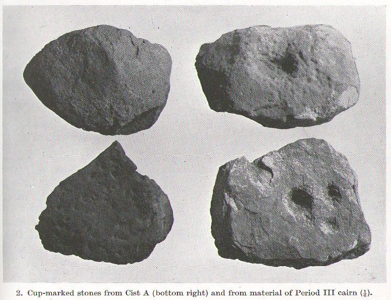
A profile of two seemingly trivial cup-marked stones is called for, out of memory for the carvings and also because they are now hidden in some vault somewhere, out of view in one of the Scottish museums I presume. In visiting the impressive Cairnpapple Hill the other day, I thought that the carvings should really be in situ, where they belong, and not in a box somewhere for the eyes of just a privileged few.
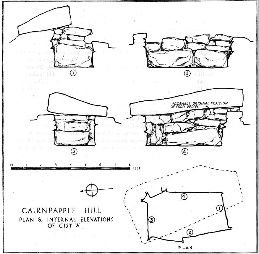
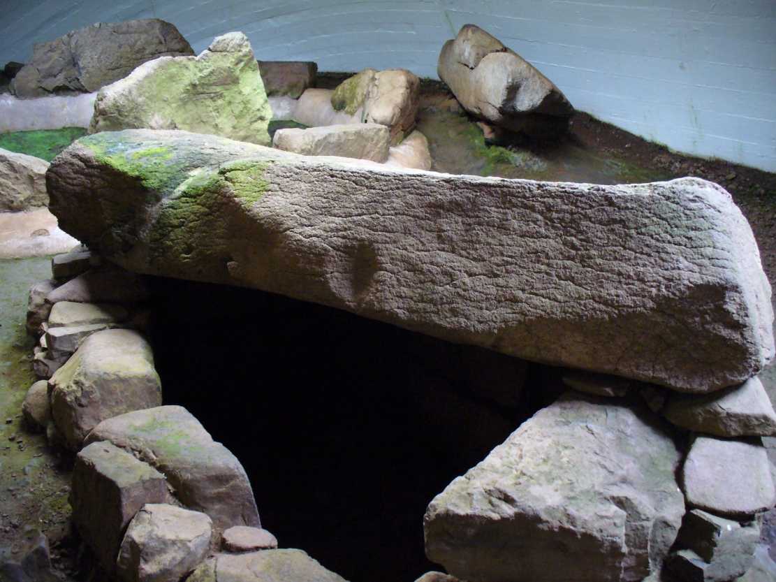
Cairnpapple Cist A
Two small, single, almost portable-sized stones—not unlike other cup-marked rocks found at sites like the Little Skirtful of Stones and elsewhere—were unearthed during the primary excavation of Cairnpapple by Stuart Piggott in the late-1940s. Although there are many stone-lined cremation pits and graves at Cairnpapple, only one of the tombs seemed to possess any carvings—and these were found only in the western walling in one of the larger of the two tombs that are now housed inside the modern covering tumulus, in what Piggott (1950) called ‘Cist A’. (Curiously in all sketches of the tomb, he didn’t show where the carvings were found, typical of some archaeologists of that period who saw little importance in these relics.)
Cist A capstone, with large cup
The giant stone roof or covering stone to Cist A also has a large worked cup-marking on its western side. There are also what seems to be other faint rectangular etchings on the same rock-face, but the age and nature of these elements need to be assessed with some caution.
References:
Cox, Adrian, Cairnpapple Hill, Historic Scotland: Edinburgh 2010.
Various ways to get here: from Bathgate either take the Drumcross Road eastwards and up, or north up the Puir Wife’s Brae till you reach the crossroads where, upon the hillock north, you’ll see the old stone standing on the ridge. If you come down from Cairnpapple Hill (as most visitors are likely to do), go south for more than a mile and keep your eyes peeled in the fields to your right, shortly before the staggered crossroad. You can’t really miss it.
Archaeology & History
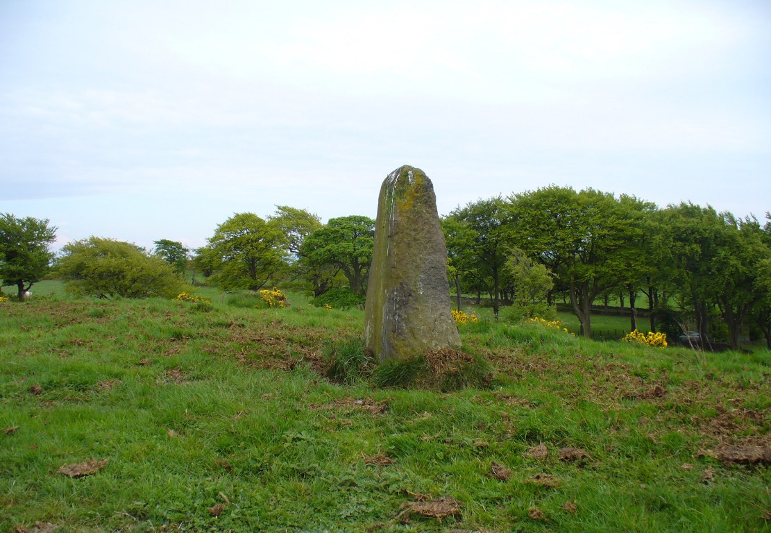
Gala Braes standing stone
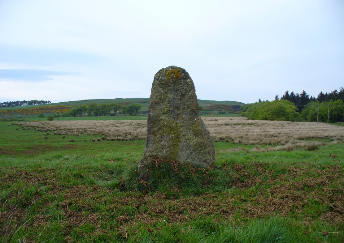
About a mile south of the superb Cairnpapple Hill, in a well-manured field at the edge of a small ridge with a vast view to the south and west, this now-solitary standing stone lives quietly and alone, gazing over its old landscape. Standing about 5½ feet tall, it seems as if the monolith has been split along its southern side at some time in the not-too-distant past, leaving a damaged wedge-shaped monolith, with one very thin eastern edge and a wider western side. The stone itself was erected to align roughly north-south-east-west.
The monolith was first shown on the 1854 Ordnance Survey map of the region, along with its fallen companion (Gala Braes 2) nearly 75 yards to the west, but descriptions of the place by antiquarians are scarce. Not until Fred Coles (1903) visited here did we gain a decent account. He wrote:
“I examined this site in August 1902. It is about a mile to the east of Bathgate, and occupies the summit of a ridge extending some 300 feet westwards of the byroad that branches off due N, near the farm of Clinkingstane. The ridge is about 850 feet above sea-level. On reaching it, I found but one Standing Stone,—a rough whinstone boulder, split very unevenly, and jagged on the south side, very smooth on the two shorter sides, and girthing at the base 10 feet 5 inches. The longest edge trends WNW and ESE. It stands 5 feet 3 inches high and occupies the highest spot on the ridge.”
Whilst Mr Coles was pottering about, the courteous local farmer approached him and they began chatting about the old place—as tends to happen more than often in olde Scotland. When he,
“…asked if any digging had ever been made at either of these stones, Mr Carlaw replied that many years ago an old Bathgate worthy known as “The Apostle” persuaded his (Carlaw’s) father to dig at the base of the upper Standing Stone (the one at present erect), and they found human bones. The farm of Gala Braes has been in the tenancy of a Carlaw for upwards of a century.”
Whatever became of the old bones isn’t known. A few years later, the Royal Commission (1929) lads bimbled over to check the place out and found that it was still very much as Coles had described more than twenty years earlier, but added, “it bears no trace of sculpture.” This has since changed. Faint outlines of lettering, seemingly only a hundred years old perhaps, have been etched onto its northern face. As for the etymology of this place, Coles (1903) suggested:
“Assuming, however, that the bones found at the upper Stone were human, and taking cognisance of the fact that throughout Scotland there are many knowes, hills, hillocks and laws which are distinguished by the epithet Gallow or Gala, and that in or at many of these human remains and interments (some of them prehistoric) have been discovered, we may place this site on the Gala Braes of Bathgate in the same general group.”
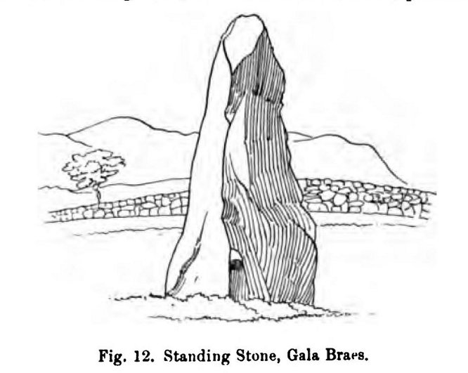
Gala Braes, with Cairnpapple Hill to rearFred Coles’ 1903 drawing
Curiously he makes no mention of the nearby ‘Clinkingstane’ a few hundred yards east: an etymological curiosity that Angus MacDonald (1941) thought may have derived from a “knocking stone”; but is a word with hosts of dialect meanings, making it difficult to define with any real certainty (at the moment anyway). Just past the Clinkingstane we had the “cross on the ridge” of Drumcross—on the same ridge as our standing stones—which may well have been an attempt to keep people away from our older, more authentic heathen heritage.
The late great Alexander Thom (1990:2:341) also visited the site, but despite its impressive landscape setting and relative proximity to Gala Braes 2, he could find no astronomical orientations here. For Thom, that’s a feat in itself!
Standing Stone (destroyed): OS Grid Reference – NS 99 77
Archaeology & History
Not included in the Canmore listings, nor that of the Scottish Royal Commission (1929), this lost standing stone once stood somewhere in Linlithgow town itself. It was referred to in the huge but obscure Registrum Magni Sigili Regum Scotorum from 1586 through to 1614 as one of the street-names in the town, written several times as ‘Standandstane’ — which, as MacDonald (1941) told in his fine survey, means literally a “Standing Stone.” The place was also referred to several times in other local accounts, dating from 1664, but was last mentioned in 1699 and, it appears, disappeared soon afterwards.
Perhaps some record of the site may be available in local witchcraft or folklore accounts. Does anybody know?
References:
MacDonald, Angus, The Place-Names of West Lothian, Oliver & Boyd: Edinburgh 1941.
Royal Commission on the Ancient & Historical Monuments of Scotland, Inventory of Monuments and Constructions in the Counties of Midlothian and West Lothian, HMSO: Edinburgh 1929.