Chapel Lane Well, Crawshawbooth, Rossendale, Lancashire

Healing Well (destroyed):  OS Grid Reference – SD 8136 2585

Archaeology & History

The name of this seemingly lost site—Chapel Lane Well—suggests it may have possessed that traditional ‘holy’ association, but neither custom nor history has bedecked us with information to give certainty to such an idea.  Even the name of the road along which it was found was one ascribed only by local folk in the 19th Century, for the old maps show us it to have been Goodshaw Lane—but the locals in this neck o’ the woods preserved many an old way that fell foul of the boring Industrialist writers of that age.  Except for one, thankfully!

J.M. Mather was a true ambling rambler like my self, wandering off-path, in all weathers, and dreaming by the chimes of swirling waters in stream and spring alike, moving betwixt the roars of biting gales in wintry heights and quietudes of moorland nights gazing at falling stars.  And thankfully his pen left us with a smattering of old tales from the tongues of local folk not considered worthy by the Industrialists and christian historians of his time.  Mather, instead, wrote of the actual history of Rossendale: of the ways of the people and moods of the hills…

The Chapel Lane Well was on the left-side of the road as you head up to Goodshaw Chapel, just where the track leads off up to Folly Bank Farm: “a quaint looking house”, even in his day!  It was, he said, where “the legend of the Chapel Snake still survives.”

“Many years ago, when people came from the village beyond to draw from its waters, in the dusk of one evening an hysterical girl declared she saw a white snake in the liquid depths. The alarm soon spread, and for days none dared to approach, until the want of water and the toil entailed by having to wander further for it, led to a solemn conclave of villagers.  Amongst those composing it was a doughty sexton, who, seeing the fears of his friends, declared that he would shoot the snake. Armed with his gun, he cautiously approached. Seeing what he supposed to be the snake, lying in serpentine form, white upon the waters, he fired ; but when a careful inspection was made, the object of delusion was found to be a knitted garter. This, in the depths of the well, and seen by an hysterical girl, had led to the panic, the heroism of a sexton, and the final amusement of the neighbourhood.  The well is still there, and in use.”

But some time after Mather wrote those words, the waters were blocked and it has long since fallen into history.  As if to compensate and still flowing, are waters not far from here that were known as the abode of the great and dreadful fairy creature known as Jenny Greenteeth!

References:

  1. Mather, J. Marshall, Rambles Round Rossendale – volume 2, J.J. Riley: Rawtenstall 1894.

© Paul Bennett, The Northern Antiquarian 

St. Nicholas’ Well, Carlisle, Cumbria

Holy Well (destroyed):  OS Grid Reference – NY 405 551

Archaeology & History

On the far south-side of Botchergate running out of central Carlisle, could once be seen the Hospital of St. Nicholas that was mainly used for the treatment of lepers, and in a field very close by could once be found a healing well apparently dedicated to the saint, but which was destroyed following the construction of the railway through the town.  It was described by a Mrs Cartmell to the historian Henry Barnes (1906) who told him that it “had a great reputation, its water being considered a valuable remedy for sore legs, or sores on any part of the body”—hence being of value in the treatment of leprosy.

The site was described briefly in McIntire’s (1944) holy wells survey, where he added that in the 19th Century, “it was still visited in May by people who filled their ‘shaking bottles’ with the water.”  Beltane rites are common at holy wells.  The feast day of St. Nicholas is December 6.

References:

  1. Armstrong, A.M., Mawer, A., Stenton, F.M. & Dickins, B., The Place-Names of Cumberland – volume 1, Cambridge Univerity Press 1950.
  2. Barnes, Henry, “On a Stone Coffin and Chalice found at St. Nicholas’, Carlisle,” in Transactions Cumberland & Westmorland Antiquarian & Archaeological Society, volume 6 (Series 2), 1906.
  3. McIntire, Walter T., “The Holy Wells of Cumberland,” in Transactions Cumberland & Westmorland Antiquarian & Archaeological Society, volume 44 (New Series), 1944.

© Paul Bennett, The Northern Antiquarian 

St. Helen’s Well, Botcherby, Carlisle, Cumbria

Holy Well (lost):  OS Grid Reference – NY 42 55

Also Known as:

  1. St. Elena’s Well

Archaeology & History

There’s a possibility that some trace of this seemingly lost sacred well might still be found.  It was first described in 1233 CE as the fountain of St. Ellen and the land hereby was given to monks who lived here.  The stream which emerged from St. Helen’s fountain (fontis Sanctæ Elenæ), or well, was known as “the stream of the Holy Fountain of St. Elena”, and this was also mentioned in the same 13th Century charters, but sadly no traditions regarding the site were mentioned.  The waters however, were likely venerated around St. Helen’s feast day, of August 18.

The Well was found to the east-side of old Botcherby village (now swallowed into the expanding Carlisle suburbia), heading towards Scotby, with the description in the Charter indicating its source was much closer to Botcherby, perhaps just over the old township boundary.

When Walt McIntire (1944) did his survey of the region’s holy wells, he was as unsure about its location as I am, merely telling:

“”St. Helena’s Spring,” mentioned in a charter of Walter of Botcherby to the monks of Wetheral c. 1235 as situate between Botcherby and Scotby.”

So where was it? —or is it?  Are there any Carlisle historians out there who’ve found its hallowed spot…? (Note: the grid-ref I’ve given to this site is obviously an approximation)

References:

  1. Armstrong, A.M., Mawer, A., Stenton, F.M. & Dickins, B., The Place-Names of Cumberland – volume 1, Cambridge Univerity Press 1950.
  2. McIntire, Walter T., “The Holy Wells of Cumberland,” in Transactions Cumberland & Westmorland Antiquarian & Archaeological Society, volume 44 (New Series), 1944.
  3. Prescott, J.E. (ed.), Registry of the Priory of Wetherhal, Elliot Stock: London 1897.

Acknowledgements:  Huge thanks for use of the Ordnance Survey map in this site profile, reproduced with the kind permission of the National Library of Scotland.

© Paul Bennett, The Northern Antiquarian 

St. Cuthbert’s Well, Carlisle, Cumbria

Holy Well (destroyed):  OS Grid Reference – NY 400 559

Archaeology & History

In Walt McIntire’s (1944) survey of Cumbrian holy wells, he mentioned this one, long since covered over, near the middle of the old city, saying:

“‘St. Cuthbert’s Well,’” recorded by Bede in his account of St. Cuthbert’s visit to Carlisle in 685.  The site of this well is supposed to have been in the market-place, near the premises now occupied by Messrs. Thurnam & Son. It was formerly protected by a curious erection known as Carnaby’s folly, which subsequently was used as a fish market, until it was removed by the Corporation.”

The old well was mentioned in Jefferson’s (1838) early survey of the city, although he didn’t associate St. Cuthbert with the waters, merely telling,

“At the north end of the shambles was a draw-well, over which was a building supported by pillars, called Carnaby’s Folly.  Adjoining to this, was the fish market.  The shambles and the Folly were taken down in the latter end of the last century the latter having been purchased, at a great price, by the corporation.”

There is however, the St. Cuthbert’s Lane leading to the church dedicated to the same chap, previously known as St. Cuthbert’s Vennel and so-named as far back as 1378 CE.  The proximity of the old Market Cross to St. Cuthbert’s Lane suggests the usual association between sacred wells, old stone crosses and the gathering of traders and village folk alike.

Folklore

St Cuthbert’s feast was March 20 – a festival tacked on to the Spring Equinox.  He was a hermit and a saint of the early Northumbrian church in the Celtic tradition.

References:

  1. Armstrong, A.M., Mawer, A., Stenton, F.M. & Dickins, B., The Place-Names of Cumberland – volume 1, Cambridge Univerity Press 1950.
  2. Jefferson, Samuel, The History and Antiquities of Carlisle, S. Jefferson: Carlisle 1838.
  3. McIntire, Walter T., “The Holy Wells of Cumberland,” in Transactions Cumberland & Westmorland Antiquarian & Archaeological Society, volume 44 (New Series), 1944.

© Paul Bennett, The Northern Antiquarian 

St. George’s Well, Taunton, Somerset

Holy Well (lost):  OS Grid Reference – ST 231 243

Also Known as:

  1. Fons George

Archaeology & History

This once important holy well seems to have been lost or covered over.  It was mentioned several times in Edward Jeboult’s (1873) huge survey of the county and he located it “to the south of the church” of St. George in Wilton where, in his day, a spring of water could be seen. He told that, in the parish of Taunton,

“was formerly a noted spring called Fons George, or St. George’s Well, to which the afflicted were accustomed to resort, and which tradition reports to have worked many marvellous cures. The site of this well seems now uncertain.”

In Ethelbert Horne’s (1923) survey, it seems he couldn’t locate the site as he gave no description of the well, but merely echoed the account given by Mr Jeboult.  Does anyone know what happened to it?

References:

  1. Horne, Ethelbert, Somerset Holy Wells and other Named Wells, Somerset Folk Series: London 1923.
  2. Jeboult, Edward, A General Account of West Somerset, Somerset & Bristol Steam Press: Taunton 1873.

© Paul Bennett, The Northern Antiquarian 
God’s Well, Arkesden, Essex

Sacred Well:  OS Grid Reference – TL 467 356

Archaeology & History

Located in the copse known as Godwell’s Grove on the western boundary of Arkesden, there are good grounds for thinking this was a sacred well: not necessarily relating to the christian God, but what A.H. Smith (1956) described simply as, from the old English, “a (heathen) god.”  Another site of the same name is found in Wiltshire.  In the local survey by Parish (2010), he told that “its name suggests it is a holy well.”

In Reaney’s (1976) survey on English place-names, he looks at a number of places where the element “god” is found and explores the notion of them recording a personal name, Gode.  This is evident of course, but he stated that,

“it would indeed be a remarkable coincidence if all these names…were to contain the personal-name Gode, a short form of Godric, Godwine, etc.  It in inconceivable that the reference should be to the christian deity… All are situated in areas of early settlement where heathen place-names might be expected and may well contain OE god, ‘a god’.”

There is no longer any trace of the well.

References:

  1. Parish, R.B., Holy Wells and Healing Springs of Essex, Pixyled Press: Nottingham 2010.
  2. Reaney, P.H., The Place-Names of Essex, Cambridge University Press 1935.
  3. Reaney, P.H., The Origin of English Place-Names, RKP: London 1976.
  4. Smith, A.H., English Place-Name Elements – volume 1, Cambridge University Press 1956.

© Paul Bennett, The Northern Antiquarian

Beltane Well, Kenmore, Perthshire

Sacred Well:  OS Grid Reference – NN 7867 4725

Also Known as:

  1. An Tobar
  2. Holy Well of Inchadney

Getting Here

An Tobar, or Beltane Well, on the 1867 map

An Tobar, or Beltane Well, on the 1867 map

From Kenmore village on the north-side of the river, over the bridge, take the small road on your right towards Dull.  After a very short distance the road runs alongside the woodland for nearly 1½ miles until, on your left, you’ll reach Drummond Cottage.  Across from here a dirt-track takes you into the trees.  Barely 100 yards along, watch for the overgrown path that runs down the slope on your left.  At the bottom a small stream has several feeds – one of which is surrounded by a ring of bright quartz stones.

Archaeology & History

Shown on the early Ordnance Survey maps as An Tobar (meaing simply “a well”), this somewhat nondescript title betrays a much more colourful folk history, albeit dissolved by those common culprits of Church and disrespectful incomers (which shows little sign of diminishing).

Lara by the Well

Lara by the Well

Close-up of quartz surround

Close-up of quartz surround

In the field immediately south, back up the slope above the well and through the trees, was once an ancient church whose existence has all but vanished.  Hereby was held an ancient fair known as Feill nam Bann Naohm, or the Fair of the Holy Women, named after a group of nuns whose lived here, who William Gillies (1938) and others proclaim were the legendary Nine Maidens, whose dedications at wells, trees and other sites scatter Scotland. But the fair was ended in 1575 and moved to Kenmore; then, several years later in 1579, the church also moved onto Eilean nam Ban Naomh (NN 7664 4536) on Loch Tay.

The old well however, after being left by the descendants of the Holy Women or Nine Maidens, continued to be frequented by local people.  Gillies (1938) wrote:

“The Holy Well of Inchadney is situated at the foot of the terrace, about five hundred yards to the north of the churchyard… Up to the middle of last century the well used to be visited by great numbers of people on the morning of Bealtuinn, the first day of May.”

In Ruth & Frank Morris’ survey (1981) they told how the site had become much overgrown and,

“The well was cleaned out in 1914 and among articles found was a stone 21 inches by 16 inches, with a rude St Andrew’s cross scratched on it, a George III farthing among other copper coins, a rudely made stone cup 2½ inches high and 7 inches in diameter, three metal buttons, a glass bead and six pins.”

No such offerings seemed in evidence when we visited a few weeks ago; but we were told that people are still seen visiting the well.

Looking down into the pure waters

Looking into the pure waters

A small stone-laid footpath runs towards the adjacent burn from the circular well, which is almost completely surrounded by large quartz rocks.  In the well itself was a small fish, showing how clean the waters are—or as would be deemed in times of olde: a ‘guardian’ of the waters.

We must also make note of the fact that, just two fields away to the north, according to the antiquarian Fred Coles (1910), a stone circle was once in evidence.  This old well sat neatly between the sites of megalithic ring and church.

Folklore

In the field in front of the well, Hilary Wheather (1982) told that there once lived a legendary water bull, but she lamented on his passing.  With the coming of the modern-folks and their unnatural ways,

“and having great timber lorries rumbling past your home every day is no fun for a peace-loving waterbull living in Poll Tairbh, the Bull’s Pool opposite the Holy Well.  Gone are the days when he was the revered Spirit of the Meadow, passed with trembling and fear by all the young maids of the Parish lest he should jump out and carry them off to his watery lair. Half the calves of the area were sired by him and it was always easily seen which cow had the attentions of the Great Waterbull.  Her calf was always the biggest and the best.  But he hasn’t been seen by his pool for many a year…”

The waters are cited by Geoff Holder (2006) to be good for toothache.

References:

  1. Coles, Fred, “Report on Stone Circles Surveyed in Perthshire (Aberfeldy District),” in Proceedings of the Society of Antiquaries, Scotland, volume 44, 1910.
  2. Gillies, William A., In Famed Breadalbane, Munro Press: Perth 1938.
  3. Holder, Geoff, The Guide to Mysterious Perthshire, History Press 2006.
  4. McHardy, Stuart, The Quest for the Nine Maidens, Luath Press: Edinburgh 2003.
  5. Miller, Joyce, Magic and Witchcraft in Scotland, Goblinshead: Musselburgh 2010.
  6. Morris, Ruth & Frank, Scottish Healing Wells, Alethea: Sandy 1982.
  7. Wheater, Hilary, Kenmore and Loch Tay, Appin Publications: Aberfeldy 1982.

Acknowledgements:  Big thanks to the bunch who got us here:  to Paul Hornby, Nina Harris, Aisha Domleo & Lara Domleo (ooh – and Leo too!).

© Paul Bennett, The Northern Antiquarian


Our Lady’s Well, Straiton, Loanhead, Midlothian

Holy Well (destroyed):  OS Grid Reference – NT 2728 6669

Archaeology & History

Our Ladys ‘Well’ on 1855 map

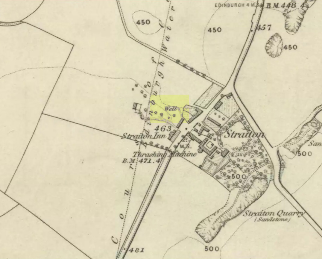
This is another all-but-forgotten holy well once dedicated to the Virgin Mary, close to the south-side of Edinburgh’s outer ring-road.  It would seem to have been one in a cluster of sacred wells not far from each other (with the two Jacob’s Wells and St. Margaret’s Well at nearby Pentland), whose traditional stories have fallen prey to the incredulity of ‘progress’.  I can find very little about the site, other than the note given it in George Good’s (1893) Liberton survey where, in stepping south towards the old hamlets of Broomhill and Straiton, he told:

“A little to the west of the hamlet, and near what was called Straiton Green, is an old draw-well dedicated to the Virgin, and known by the name of Our Lady’s Well. There may possibly have been a cell or chapel near this well, but no tradition or history regarding it is extant.”

We can only presume that the ‘Well’ which is highlighted on the first OS-map in 1855, maybe 20-30 yards west of the old road on what looks like a small park or ‘Green’, would be the ‘Lady Well’ in question. (another ‘Well’ is shown at Broomhill Cottage, which is unlikely to be the contender)

References:

  1. Bennett, Paul, Ancient and Holy Wells of Edinburgh, TNA 2017.
  2. Good, George, Liberton in Ancient and Modern Times, Andrew Elliot: Edinburgh 1893.

© Paul Bennett, The Northern Antiquarian


Tobair na h-oige, St. Kilda, Outer Hebrides

Sacred Well (lost):  OS Grid Reference – NA 100 000

Also Known as:

  1. Well of Eternal Youth

Folklore

An old story told in previous centuries by the indigenous folk of Hirta (St. Kilda) described a long-lost well that was thought to be an abode of the little people, known as the Well of Eternal Youth.  Not to be confused with the Well of Virtues near the Amazon’s House less than a mile west, the rough whereabouts of this site is cited by J. Sands (1878) in the folklore section of his otherwise historical account on these faraway Atlantic islands.  He wrote:

“Once on a time an old fellow, in going up Connagher with a sheep on his back, observed a Well which he had never seen or heard of before.  The water looked like cream, and was so tempting, that he knelt down and took a hearty drink.  To his surprise all the infirmities of age immediately left him, and all the vigour and activity of youth returned. He laid down the sheep to mark the spot, and ran down the hill to tell his neighbours. But when he came up again neither sheep nor well were to be found, nor has any one been able to find the Tobair na h-oige to this day.  Some say that if he had left a small bit of iron at the well—a brog with a tacket in it would have done quite well—the fairies would have been unable to take back their gift.”

Explorations of old maps and texts has failed to show with certainty where this legendary well may have been (the grid-ref is an approximation), but it was reported in Mrs Banks’ Scottish Calendar Customs (1937) to have been “issuing out of the face of a rock on the north-side of the east bay…only accesible by the inhabitants, no stranger daring to climb the steep rock.” Some of us would try!

References:

  1. Banks, M. MacLeod, British Calendar Customs: Scotland – volume 2, Folklore Society: London 1937.
  2. Sands, J., Out of the World; or Life in St. Kilda, Maclachlan & Stewart: Edinburgh 1878.

© Paul Bennett, The Northern Antiquarian


Bogle’s Well, Glasgow, Lanarkshire

Sacred Well:  OS Grid Reference – NS 597 650

Archaeology & History

Of all the ancient wells in the city of Glasgow, this has to be one of the most intriguing! Descriptions of it are few and far between, but it is the name of the site which is of interest, to folklorists and occult historians alike.  For the word ‘Bogle’ is another term for a ‘boggart’ or goblin of some sort!  The well is mentioned in Andy MacGeorge’s (1880) excellent study in his description of ancient wells in the city. Citing notes from the 17th century, amidst many sites,

“Another was Bogle’s Well, in regard to which there is a minute of the town council “that Bogillis Well should be assayed for bringing and convoying the water of the same to the Hie street according to the right the town hes thereof,” and the magistrates are recommended to arrange for having this done “by conduits of led.””

…Obviously in the days when they were clueless about lead-poisoning!  The word ‘bogillis’ is the early plural form of the bogle, or bogill (Grant 1941:201).  But where exactly was this old well?  Are there any other records hiding away to help us locate its original position?  It seems to have been one in a cluster of legendary and holy wells in a very small area scattered between Glasgow’s cathedral, down the High Street and to the northern banks of the River Clyde… (the grid-reference given for this site is an approximation)

In a less esoteric fashion, the occult historian Jan Silver suggested that the name of the Well may relate to the family name, ‘Bogle’.  This could indeed be the real story behind the well’s name.

Folklore

Traditionally ascribed in the lower counties of England to be an evil malicious sprite, in more northern counties and in Scotland the creature was said by Katherine Briggs (1979) to be a more “virtuous creature”, akin to the helpful brownies or urisks of country lore.  This was said to be the case in William Henderson’s (1868) Folklore of the Northern Counties. Whether this well was haunted or the home of a bogle, we do not know as the folklore of this site appears to be lost; so I appeal to any students who might be able to enlighten us further on the place.  The Forteans amongst you might have a cluster of ‘hauntings’ hereby, perhaps….

References:

  1. Bennett, Paul, Ancient and Holy Wells of Glasgow, TNA 2017.
  2. Briggs, Katharine, A Dictionary of Fairies, Penguin: Harmondsworth 1979.
  3. Grant, William (ed.), The Scottish National Dictionary – volume 2, SNDA: Edinburgh 1941.
  4. Henderson, William, Notes on the Folklore of the Northern Counties of England and the Borders, W. Satchell: London 1879.
  5. MacGeorge, Andrew, Old Glasgow, Blackie & Son: Glasgow 1880.
  6. MacKinlay, James M., Folklore of Scottish Lochs and Springs, William Hodge: Glasgow 1893.
  7. Steele, Joyce, Seeking Patterns of Lordship, Justice and Worship in the Scottish Landscape, Glasgow University 2014.

© Paul Bennett, The Northern Antiquarian