At present we have no information or images about this site. Be the first person to contribute material by emailing us with info, field notes or photos to the usual address – megalithix@yandex.com
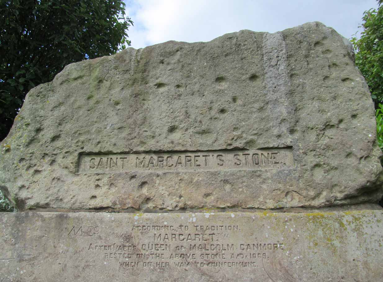
Take the A823 road out of Dunfermline south towards Rosyth. A half-mile before you hit the motorway roundabout, at the roundabout where Carnegie Avenue takes you east, turn west and park up along the road where the modern business park lives. 30-40 yards from the roundabout, set back on the pavement, you can’t really miss the huge flat slab of stone, covered in cup-markings, resting on a stone plinth with ‘St Margaret’s Stone’ stamped on it!
Archaeology & History
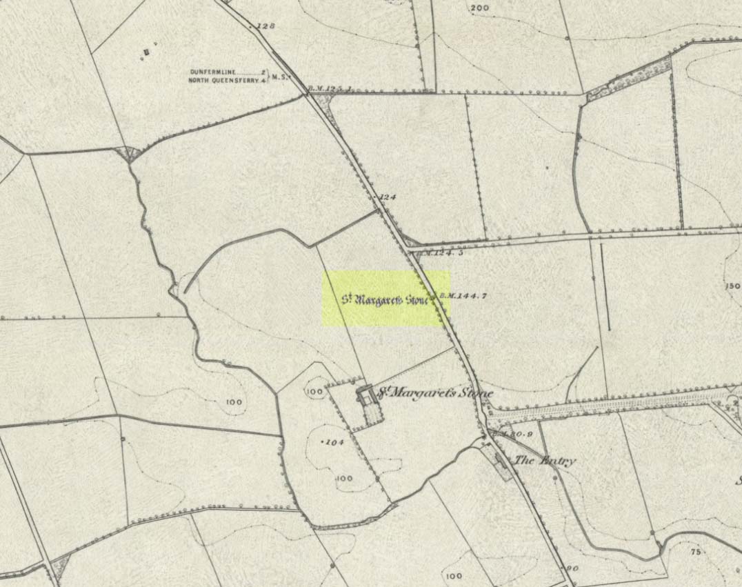
On the 1856 OS-map of this area, St Margaret’s Stone is shown at the roadside just above a farm of the same name, a short distance away from its present location. In October 1879, Alexander Stewart (1889) told us that funds were raised and steps taken to properly fix and preserve this ancient ‘resting-place’ of Queen Margaret on the Queensferry Road. It was quite a few years later before it was moved the few hundred yards further to its present location.
Cups on stone’s edge
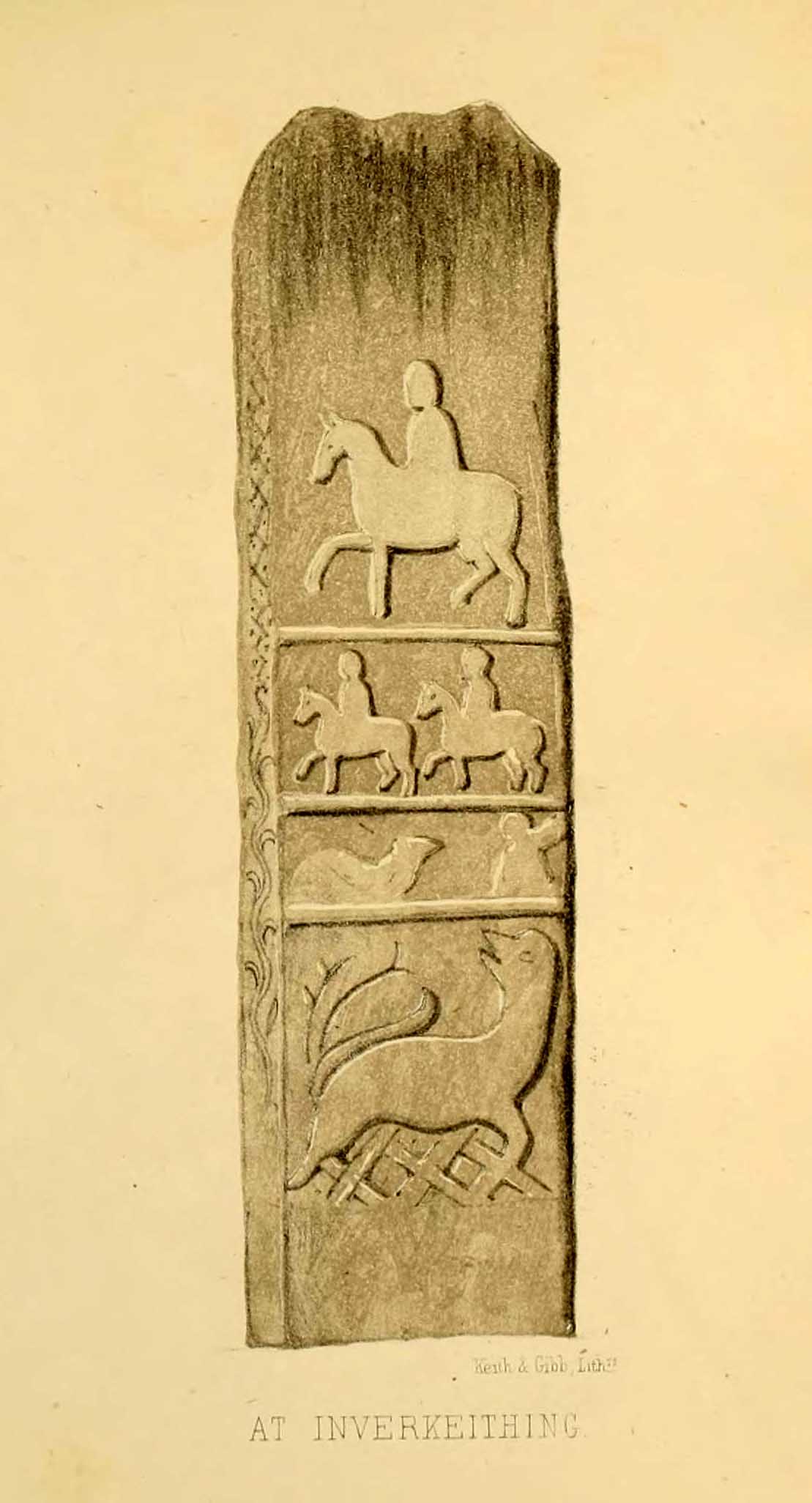
Early writers tell us that originally its position in the landscape was on the crest of one of the rises in the land between Dunfermline and the sea, making it visible for some considerable distance. This would seem to have been a deliberate placement. In my mind, and in accordance with the placement of many a prehistoric tomb, St Margaret’s Stone may originally have been part of a neolithic or Bronze age cairn, long since gone. The size and shape of the rock implies it too, with similarities here of the impressive cist or gravestone found inside the Netherlargie North cairn at Kilmartin. However, this wasn’t the thought of the prodigious Scottish historian, William Skene. He thought that St Margaret’s Stone originally stood upright, being a Pictish-style standing stone that was mentioned in the first Statistical Account of the area. The brilliant Scottish antiquarian, John Stuart (1856)—who gave us an illustration of the ‘standing stone’ in question—told us:
“It has been supposed by some that “St. Margaret’s Stone,” a block now lying on the side of the highway leading from Inverkeithing to Dunfermline, and about midway between these places, can be identified with the standing stone referred to in the Statistical Account. Mr Skene has noted below a sketch of St. Margaret’s Stone:- “The sculpture upon this stone has been lately chipped off in mere wantonness, so as to leave few traces of the subject recorded upon it.” He farther states that it formerly stood erect, and was called “The Standing Stone.” According to Mr. Skene’s measurement, St. Margaret’s stone is about nine feet and a half in length, one foot in thickness, and four feet broad at the widest end, and broken off to a narrow point at the other.”
The missing ‘standing stone’
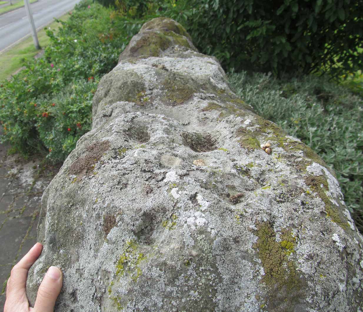
In this instance, Skene was confusing St Margaret’s Stone with the lost Pictish monolith (left) that used to exist nearby, which had carved horse figures and other memorial designs upon it and which he thought had faded away. Whereas the large slab we are looking at here, and which Skene visited and measured, is covered on one side by a gathering of prehistoric cup-markings—much earlier than any Pictish or early christian carvings. At first glance, it seems that some of these cups may well be natural, but it has to be said that some of them are distinctly man-made. And if we were to believe the archaeo-accounts of the stone, the cupmarks are only to found on one side of the stone. This is incorrect. As we can see here, a number of cupmarks run along the edge of the stone. We cannot say for sure whether all of them are artificial, but they certainly look like it! Also, on the other side of the flat surface, one or two single cups are visible. It would be good if we could get an artist to give us a detailed impression of the prehistoric carvings without the modern engraving of St Margaret’s Stone etching on the main face. (is there anybody out there!?)
The Royal Commission (1933) lads visited the stone in 1925 and, several years later in their write-up, told us simply:
“This stone…stands with its main axis due north and south and measures 8 feet 6 inches, by 4 feet 7 inches, by 1 foot 6 inches. On one side the entire surface is cup-marked, the markings varying in size from 1¼ inches to 3¼ inches and having an average depth of from ½ to ¾ inch.”
When the Scottish petroglyph writer and explorer, Ron Morris (1968) came to the site, he gave it an equally brief description, merely telling us:
“On standing stone (8 1/2 feet high, 4 1/2 feet wide), built in to roadside fence, over 80 cups, up to 4in in diam, 3/4in deep, some run together as rough dumbells.”
It’s well worth checking out!
Folklore
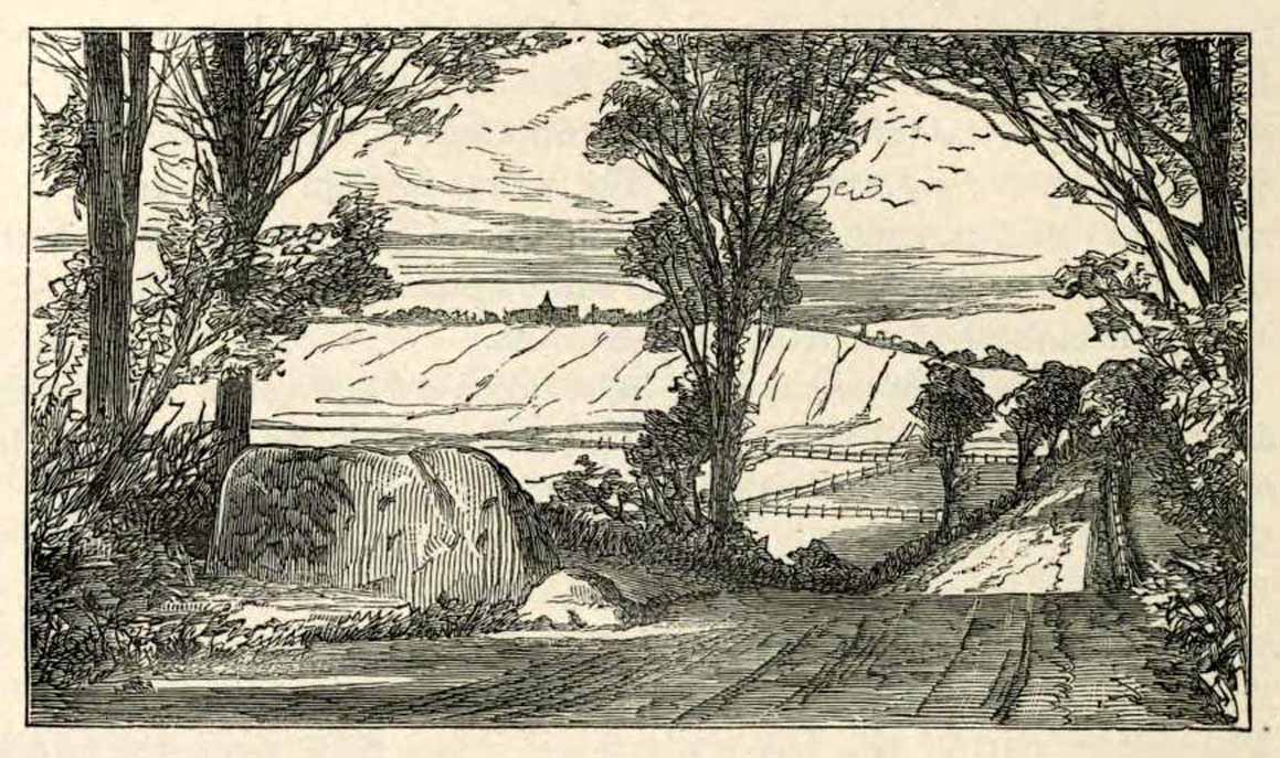
St Margarets Stone in 1825
When the Saxon Queen Margaret landed on the shores just west of Queensferry at Rosyth Castle (NT 1087 8200), legend reputes that she and her entourage made Her way north towards Dunfermline. Halfway along the ancient track She rested at this large stone which, thereafter, gained the name by which we know it today. It was said that Queen Margaret subsequently visited the stone on a regular basis for periods of solitude. The tale probably has some germ of true in it. Additional ingredients also told that,
“The large stone here is associated with St Margaret and was visited by women who hoped to conceive or sought a successful birth. The eight-foot high stone is said to mark the resting place of St Margaret when she journeyed between Queensferry and Dunfermline. Margaret had eight successful pregnancies and probably needed to rest quite a few times on her travels!”
The fertility aspects of the rock were not the only pre-christian virtues attached to it. We also find that oft-cited motif of rocks moving of their own accord: in this case, as J.B. MacKie (1905) told us, local people had always
“been told that the stone rose from its bed and whirled thrice round in the air every time it heard the cock at the adjoining farm crow.”
Cocks crowing are symbolic of sunrise, obviously, and this lore may simply represent a folk memory of the spirit in/of the stone being animated at that time of day. It’s a motif found at ancient sites all over the place!
Royal Commission Ancient & Historical Monuments of Scotland, Inventory of Monuments and Constructions in the Counties of Fife, Kinross, and Clackmannan. HMSO: Edinburgh 1933.
Rupert-Jone, John A., Rosyth, A. Romanes: Dunfermline 1917.
Stewart, Alexander, Reminiscences of Dunfermline and Neighbourhood, Scott Ferguson: Edinburgh 1889.
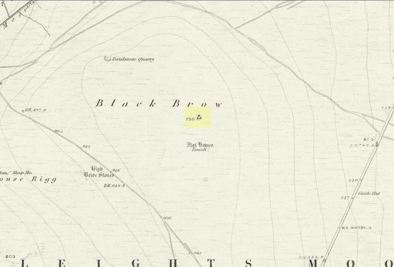
Along the A169 road that runs may miles from Whitby to Pickering, as you go through the small town of Sleights, the road gets steep for a mile or so, until you reach the moorland tops, where the road runs dead straight. After 1.2 miles (1.93km) along the straight road, a small minor road is to your right. Go along here for literally half-a-mile (0.8km) where you’ll see a small dirt-track on your right, with a locked gate. There’s place to park here. You’ll see the large rounded mound of Flat Howe-2 about 200 yards NE. Head there, then another 250 yards north. You’ve arrived!
Archaeology & History
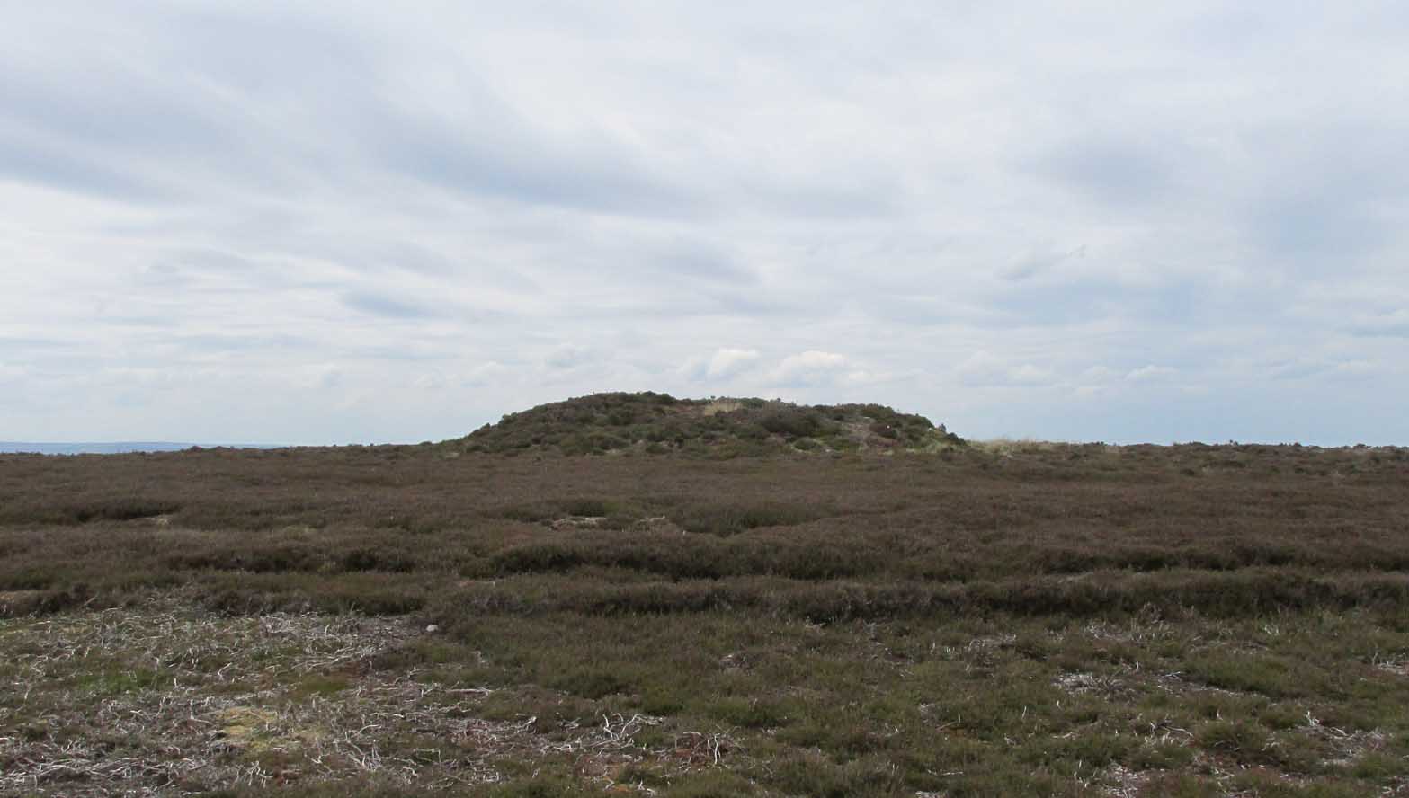
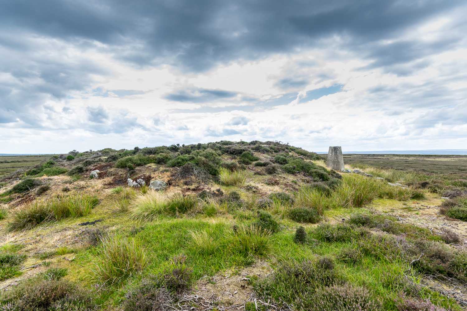
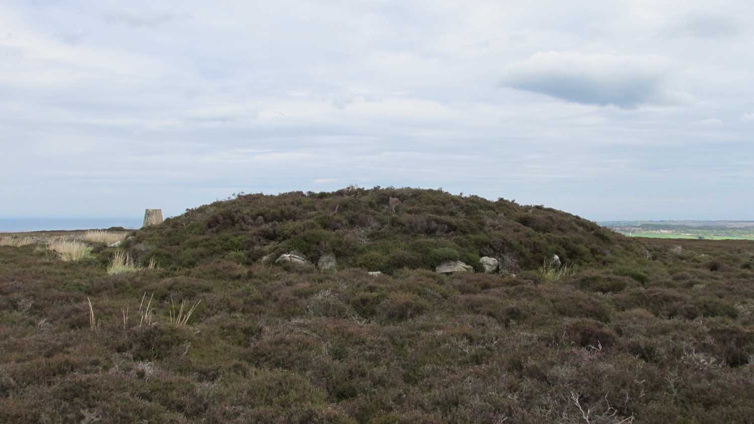
Of the two ‘Flat Howe’ burial mounds on Sleights Moor, this is the northern one of the two, being 250 yards (230m) away from its southern companion (at NZ 85510 04614). It’s quite a big fella too – and so you’d expect there to be quite a bit of information about it. But there isn’t! No recorded excavation has taken place here, despite the top of the monument being cut into. But this might have occurred when the Ordnance Survey lads built one of their triangulation pillars into the side of it. Thankfully it’s not done too much damage.
I was quite surprised to find that even Frank Elgee (1912; 1930) had little to say about either of the two Flat Howes, simply mentioning them in passing in relation to the numerous other prehistoric tombs on these moors. Despite this, the archaeologist L.V. Grinsell (1936) thought this site to be one of “the finest peristalith barrows I have ever seen.” And this one in particular is still very impressive.
Flat Howe from the southFlat Howe (by James Elkington)
First shown on the 1853 OS-map, this large heather-covered mound of earth and stone is some six feet high and measures roughly 22 yards (20m) east-west by 19 yards (17.5m) north-south. The tomb was originally constructed within a circle of reasonably large boulders, some of which were upright. These can still be seen, mainly along the western and southern sides of the monument, although many have been dislodged over time and fallen at various angles, as you can see in the photo. Whether or not these stones were erected first and then the mound built inside the ring, we do not know. It’s the highest point in the landscape on Sleights Moor, with damn good views in all directions: an element that is common to many large prehistoric tombs, for obvious reasons. Other tombs of similar size and probably similar periods in prehistory can be seen close by and on the skyline. Whether this was a deliberate visual ingredient by our tribal ancestors is difficult to say, as the moors here were covered in scattered woodlands in prehistoric times. Only detailed archaeo-botanical surveys would be able to tell us one way or the other.
Folklore
Flat Howe, with large stones defining its edge
Although we have nothing specific relating to this tomb, an olde creation myth told us that the local giants, Wade and his wife Bel, left their young son (whose name seems to have been forgotten) somewhere on Sleights Moor (which aint a big place). It is worth narrating simply because it may have related to this tomb or its companion close by. Giant legends have long been associated with the creation of many prehistoric tombs in this country and abroad. The story was first written down by George Young (1817) in his magnum opus on Whitby and the tale was subsequently re-told by many others – Mrs Gutch (1901) for one:
“Young Wade, even when an infant, could throw a rock several tons weight to a vast distance; for one day when his mother was milking her cow near Swarthoue, the child, whom she had left on Sleights moor, became impatient for the breast, and seizing a stone of vast size, heaved it across the valley in wrath, and hit his mother with such violence, that though she was not materially hurt, her body made an impression on the stone which remained indelible, till the stone itself was broken up, a few years ago, to mend the highways!”
This rock was Bel’s Rock, whose exact location seems to have been lost.
References:
Elgee, Frank, Early Man in Northeast Yorkshire, Frank Bellows: Gloucester 1930.
Elgee, Frank, The Moorlands of North-Eastern Yorkshire, A. Brown: London 1912.
Grinsell, Leslie V., The Ancient Burial Mounds of England, Methuen: London 1936.
Gutch, Mrs, County Folk Lore – volume 2: Examples of Printed Folk-lore Concerning the North Riding of Yorkshire, York and the Ainsty, David Nutt: London 1901.
Jeffrey, P. Shaw, Whitby Lore and Legend, Home: Whitby 1923.
Roberts, Anthony, Sowers of Thunder, Rider: London 1978.
Smith, A.H., The Place-Names of the North Riding of Yorkshire, Cambridge University Press 1928.
Young, George, A History of Whitby and Streoneshalh Abbey – volume 2, Clarke & Medd: Whitby 1817.
Acknowledgements: A huge thanks to Lindsay Mitchell for getting us up to see this great tomb and its companion; and to James Elkington for use of the photograph.
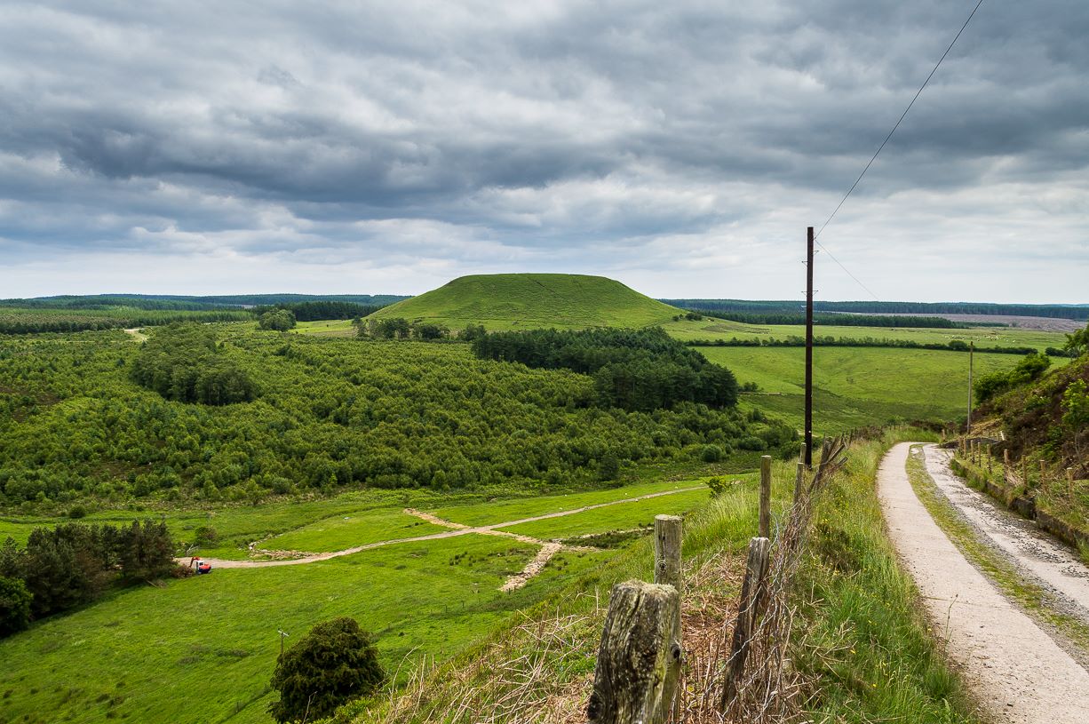
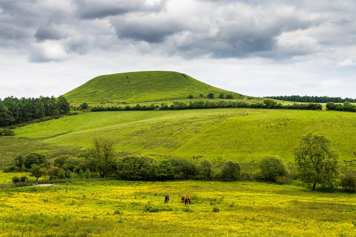
From Pickering, take the A169 towards Whitby. When you get to the Car Park at the ‘Hole-of-Horcum’ – (you can’t miss it), park the car and walk North along the side of the road towards Whitby. After 60 yds, take the track East. Follow this for approximately a mile until the track splits. Take the concrete track left towards the farmhouse of ‘Newgate Foot’. Go through the yard past the house on the right, and you will come to a stream and a gate and there, ahead of you, rises Blakey Topping…
Archaeology & History
The giant hill of Blakey Topping was recorded as early as 1233 CE and in a simplistic style just means the ‘black mound’; but this derivation has additional ingredients, implying it as a ‘black meeting-place’ or moot. Black in the etymological sense also implies ‘shining’ and it may also relate to the northern airt of black (meaning death, darkness, north, etc), when you’re stood at the ruined stone circle 400 yards to the south. But I’m speculating here…
Several 19th century antiquarians suggested there may have once been a cairn on top of the hill, but others who’ve explored this idea seem to have put it to bed.
Folklore
This great hill is well recognised amongst local people and, to this day, its animistic creation myths and other folklore elements are still spoken. When the photographer James Elkington recently visited the nearby standing stones, he bumped into the old farmer who told him how his father had seen the faerie-folk on the hill many years back. And its modern reputation as a gorgeous site adds to such lore, which dates way back.
In Frank & Harriett Elgee’s (1933) archaeology work, they narrated the old creation myth that local people used to tell of this great hill,
“A witch story related by a native 25 years ago attempts to explain two conspicuous natural features two miles apart on Pickering Moor; Blakey Topping, an isolated hill, and the Hole of Horcum, a deep basin-shaped valley. The local witch had sold her soul to the devil on the usual terms, but when he claimed it, she refused to give it up, and flew over the moors, with the devil in hot pursuit. Overtake her he could not, so he grabbed up a handful of earth and flung it at her. he missed his aim and she escaped. The Hole of Horcum remains to prove where he tore up the earth and Blakey Topping where it fell to the ground.
“From our point of view the significance of this story lies in the fact that between the Hole and the Topping there is a Bronze Age settlement site at Blakey Farm, with its stone circle. The rough trackway leading from the Hole to the circle is known as the Old Wife’s Way, presumably also marking the witch’s flight. This, together with other Old Wife’s Ways, preserves as it were Bronze Age church tracks”.
Looking up from the SW (James Elkington)
A relative variation on this tells that the Hole of Horcum was made by the local giant, Wade. He was having a row with his wife, Bell, and got so angry that he scooped out a lump of earth and threw it at her. The huge geological feature known as the Hole of Horcum is the dip left where he scooped out the earth, and Blakey topping, the clod itself, resting in situ where it landed. A christian appropriation of the story replaces Wade and his wife with their ‘devil’: a puerile element unworthy of serious consideration.
In more recent times, the old geomancer Guy Ragland Phillips (1976; 1985) found that a number of alignments, or leys (known as a ‘node’), centred on Blakey Topping: twelve in all, reaching out and crossing numerous holy wells, prehistoric tumuli, standing stones, etc. The precision of the alignments is questionable, yet the matter of the hill being a centre-point, or omphalos, would seem moreso than not.
References:
Elgee, F. & H.W., The Archaeology of Yorkshire, Methuen: London 1933.
Phillips, Guy Ragland, Brigantia, RKP: London 1976.
Phillips, Guy Ragland, The Unpolluted God, Northern Lights: Pocklington 1987.
Smith, A.H., The Place-Names of the North Riding of Yorkshire, Cambridge University Press 1928.
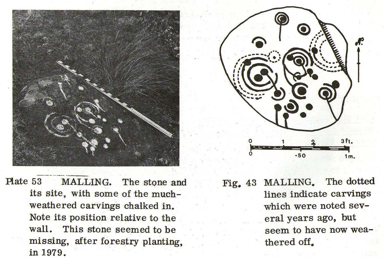
The quickest way here is bedevilled with troublesome parking (and an unhelpful local at Malling Cottage). That aside, roughly halfway along the A81 between the Braeval roundabout (near Aberfolye) and Port of Meneith, turn down the track at Malling, following it round for 300 yards through the farm, then another 500 yards or so until you reach a junction with a gate on your left. Walk down the track to your right, roughly alongside the Lake of Menteith, for nearly 700 yards until you reach the gate into the forestry commission land. Go thru the gate and turn immediate right, following the fence for about 200 yards where a clump of stones lives. You’re there!
Archaeology & History
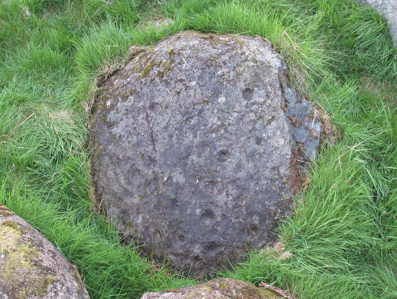
The Peace Stone in 1899
This seemingly isolated petroglyph, known about by local people in the middle of the 19th century and earlier, was said to have been “held in great reverence.” It was first mentioned in literary accounts in 1866, when the oral traditions about it were more important than any archaeocentricism. But things change with the times: local people were kicked off their lands, old stories and knowledge of sites were lost, and the ‘discipline’ of archaeology was beginning to look at these curious carved rocks with puzzled minds.
The Peace Stone was described at some length and with considerable accuracy in Mr A.F. Hutchison’s (1893) gazetteer on the ancient stones of Stirlingshire. It was one of the regions only known petroglyphs at that time and thankfully he gave us a good account of it, saying:
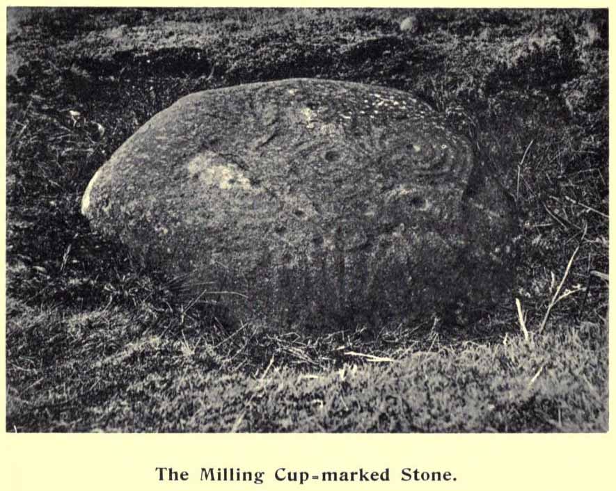
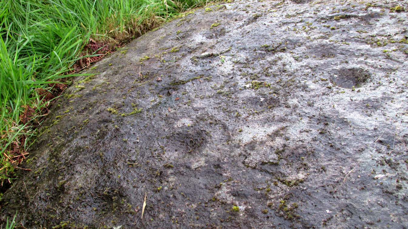
“On the west ride of the Lake of Menteith, about half a mile south from the farm-house of Malling, this stone is to be found, lying at the boundary of the arable land. The ground at the place rises into a slight eminence, on the top of which the stone lay till some seven or eight years ago, when a labourer took it into his head that a stone on which so much labour had evidently been spent must have been intended to cover something valuable. He proceeded to excavate the earth at the side with the intention of getting at the buried treasure, with the result that the stone slipped down into the hole which he had made, where it now lies. It is quite possible, however, that an interment, if no treasure, might be found beside it on further research. The stone is roughly circular on the surface, measuring about 4 feet in diameter. It is entirely covered with cup and ring marks—22 cups in all—varying in size from an inch to two inches in diameter. The cups and rings are very symmetrically formed. Nearly in the centre is a fine one surrounded by four circular grooves. Others have incomplete triple and quadruple circles, with radial duct dividing them. There are other curious curves that sometimes interlace, and near the lower side of the stone are five or six cups with straight channels running out from them over the edge. This is an extremely interesting stone. It is unique in our neighbourhood, so far as I know, in showing these symmetrical carvings. They are now, however, much weather-worn.”
Ron Morris’ sketch & photoClose-up of faded cups
When Alison Young (1938) came to write about the carving, she echoed Hutchison’s thought that the stone might originally have covered a tomb—but we simply don’t know and it should be treated as guesswork, as there are no known prehistoric tombs anywhere hereby.
Years passed before the next archaeological visit – by which time the stone had been uprooted and moved, apparently “ploughed up by the Forestry Commission”, and when Ron Morris (1981) last sought it out found that “the stone was un-traceable”. On a previous visit, before being moved, he found it to be,
“a cup-and-three-rings, 3 cups surrounded by two rings…and 6 cup-and-one-ring. One of these and 2 cups form part of the design of the cup-and-three-rings. There were also at least 7 other cups, and a number of grooves, some forming lines from a central cup, or a cup-mark, downhill. Greatest diameter visible in 1977 30cm (12in) and depth of carving 3cm (1 in)… Many of the carvings are so weathered as to be visible only when wet in early morning or late evening.”
And when we visited the site a few days ago, the stunning sunlight that had followed us all day, sadly faded and disallowed us better photographs of the site. Huge apologies…. But it’s worth visiting when the daylight’s good, perhaps when you’re exploring the huge number of brilliant petroglyphs at Ballochraggan and Nether Glenny on the hillside 1½ miles immediately north of this “outlier”, as Brouwer & van Veen (2009) called it.
Folklore
In a landscape bedevilled with stunning petroglyphs, traditions and folklore of them is all but gone; but the story of the Peace Stone was thankfully captured in words by Mr Dun (1866), who told us:
There is a curious prophecy connected with a stone situated near the ruins of the chapel of Arnchly, and which is worth recording. From time immemorial this stone went under the name of the Peace Stone, and it was held in great reverence by the natives. One Pharic McPharic, a noted Gaelic prophet, foretold that, in the course of time, this stone would be buried underground by two brothers, who, for their indiscretion, were to die childless. By-and-by the stone would rise to the surface, and by the time it was fairly above ground, a battle was to be fought on “Auchveity,” that is, “Betty’s Field.” The battle was to be long and fierce, until “Gramoch-Cam” of Glenny, that is, “Graham of the one eye,” would sweep from the “Bay-wood” with his clan and decide the contest. After the battle, a large raven was to alight on the stone and drink the blood of the fallen. So much for the prophecy then; now for the fulfilment. About fifty years ago, two brothers (tenants of the farm of Arnchly), finding that the stone interfered with their agricultural labours, made a large trench, and had it put several feet below the surface. Very singular, indeed, both these men, although married, died without leaving any issue. With the labouring of the field for a number of years, the stone has actually made its appearance above ground, and there is at present living a descendant of the Grahams of Glenny who is blind of one eye, and the ravens are daily hovering over the devoted field. Tremble ye natives! and rivals of the “Hero Grahams,” keep an eye on Gramoch-Cam!
The name of Betty’s Field came from an earlier piece of folklore: where a prince out hunting a stag was caught in one of the deep bogs hereby, only to be rescued by a local lass. In return for her help, she was given a large piece of land which was to bear her name.
References:
Armit, Ian, “The Peace Stone (Port of Menteith parish),” in Discovery & Excavation Scotland, 1998.
Dun, P., Summer at the Lake of Monteith, James Hedderwick: Glasgow 1866.
Hutchison, A.F., “The Standing Stones and other Rude Monuments of Stirling District,” in Transactions Stirling Natural History & Antiquarian Society, volume 15, 1893.
Hutchison, A.F., The Lake of Menteith: Its Islands and Vicinity with Historical Accounts of the Priory of Inchmahome and the Earldom of Menteith, Stirling 1899.
Maitland, Mrs, “Cup Marked Stones”, in The Scottish Country Woman, 1935.
Mallery, Garrick, “Pictographs of the North American Indians,” in Bureau of Ethnology of the Smithsonian Institution, volume 4, 1886.
Morris, Ronald W.B., The Prehistoric Rock Art of Southern Scotland, BAR: Oxford 1981.
van Hoek, Maarten, “Menteith (Port of Menteith parish) Rock Art Sites,” in Discovery Excavation Scotland, 1989.
Travelling South along the A916 just past Craigrothie, turn right down to Chance Inn, and turn left at the T junction. and follow the road on to just past the left hand bend when Waltonhill Farm will be seen on the right. Continue south down the road a few hundred yards until it takes a slight right turn. The De’il’s Stane, a huge flat faced slab of rock, will be seen at the roadside on the left side of the road, partly obscured by gorse.
Archaeology & History
According to a piece published in the Fife Herald & Journal in 1905:-
“Once upon a time, so runs the legend, Samson challenged the devil to match him at boulder throwing. As challenger, Samson stood on the West Lomond; Satan stood on the East. The signal was given; two mighty rocks whistled through the air. ‘The De’ils Stane’ fell where it now lies, on the road-side about a quarter of a mile west [sic] from Waltonhill Farm. Samson, though handicapped by three miles greater distance, flung his stone fully four hundred yards beyond that of Satan, and with such force that it split into three parts; which parts are now built into Waltonhill barn”.
The roadside location, just south of the bend
The De’il’s Stane, a huge slab of rock!
This is of course a variant of a creation myth that is to be found throughout Britain, of an Age of Giants who hurled rocks around and strode the land quarrelling with each other and the mortal humans . The original names of the Waltonhill Giants have been lost in the aeons of oral transmission of the legend from pre-history, and replaced by that of a probably equally legendary Middle Eastern strong man from the Christian’s Bible, in combat with the Christian’s Naughty Man. And this was of course done to prove the point of Christianity’s superiority over the old animistic cults of the land, and the De’il had to be demonstrably the loser.
De’ils Stane thrown by the Man in the Red Velvet Suit from East Lomond (Left)
Owing to the Stone being partly hidden by gorse, it was not possible to make a close inspection of the rock for carvings etc. A further visit will no doubt be made to try to clear some of the gorse so a closer inspection can be made. The Stone’s size (approximately 15′ high by 20′ wide by 4′ thick) and the way it is resting against a natural bank, does give a credence to the legend of its having been slung by a giant from East Lomond, clearly visible nearly 7¾ miles away.
Reference:
Fife Herald & Journal, 1st November 1905, quoted in John Ewart Simpkins’ County Folklore – Volume VII: Fife, with some notes concerning Clackmannan and Kinross-shires, Folk-Lore Society by Sidgwick& Jackson: London 1914.
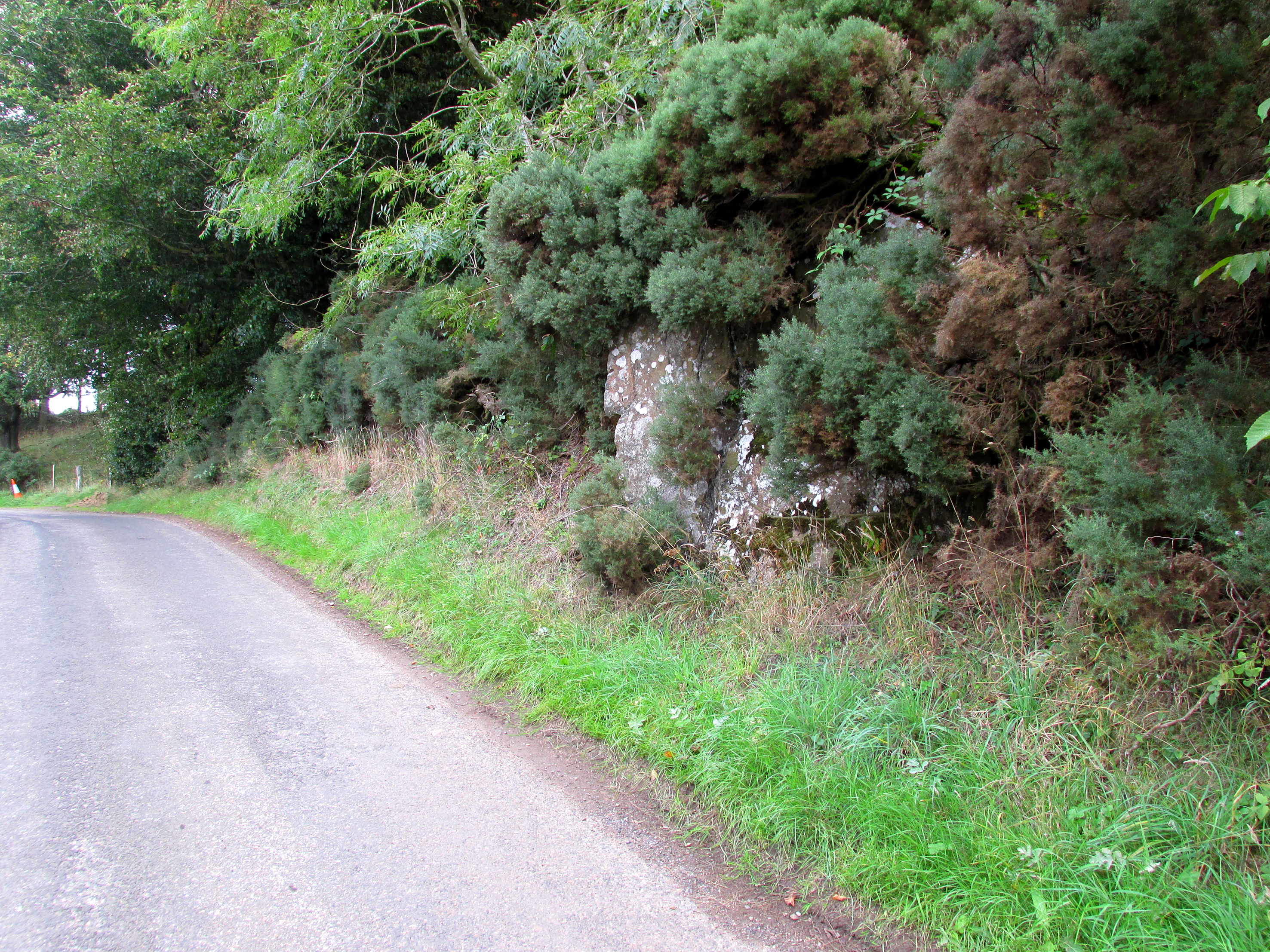
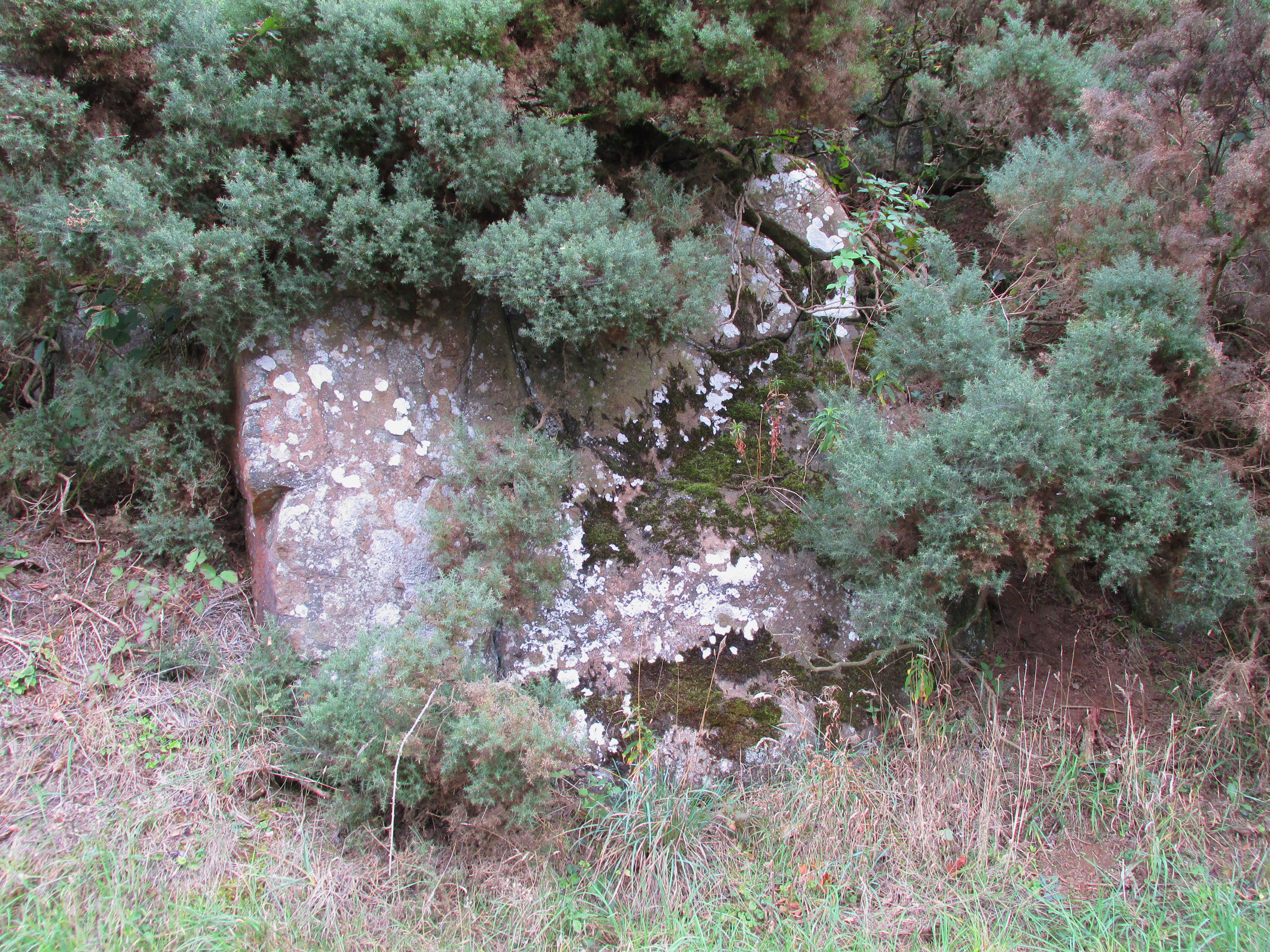
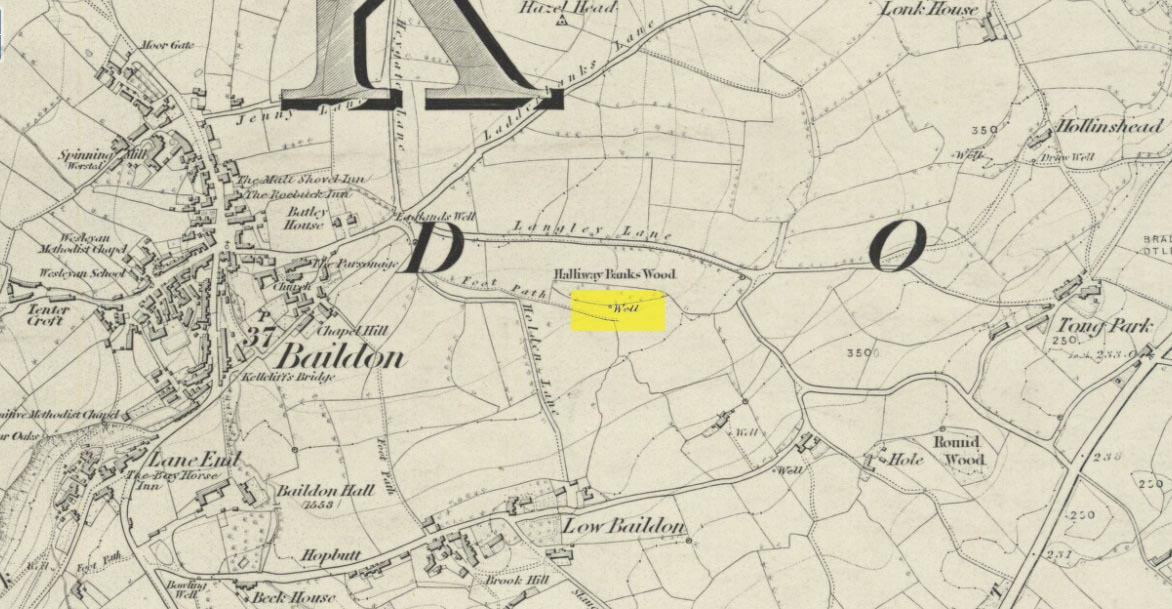
Holy Well (destroyed): OS Grid Reference – SE 1609 3961
Archaeology & History
This site is all but unknown to the great majority of folk in Baildon, and even some of the local historians have let it slip from their investigative tendrils. According to the primary Baildon historian, W.Paley Baildon, it was first known as the ‘Halliwell Holy Well’. In his magnum opus (1913-26) of the township he relates that,
“The 1852 Ordnance map marks Halliway Banks Wood to the south of Langley Lane, with a well just below it, and a footpath from Holden Lane to the well. Halliway, I think, is a corruption of Halliwell, the ‘holy well,’ with the special footpath leading to it and nowhere else. Haliwell Bank occurs in (the Baildon Court Rolls of) 1490, when it formed part of the property held by William Tong of Nicolas Fitz William.”
This etymology is echoed by the great place-name authority A.H. Smith (1954). It also caught the attention of archaeologist Andrea Smith (1982), in her investigation of twenty-five holy wells in the West Yorkshire region.
“Many wells,” she wrote, “are recorded simply as ‘Holy Well,’ or the various forms ‘Halliwell,’ ‘Helliwell’ and ‘Hollowell.’ It is possible that in these instances the identity of the patron saint or guardian of the well has been forgotten, which may be the case with the site at Collingham, now known as Hollowell.”
Site of the Holy Well in 1852
The well itself can no longer be seen. When I looked for the site in 1982, I found that to the right of where the 1852 map showed it, was a waterworks lid covering the old holy waters, just in the trees atop of the field beneath a great sycamore with a number of small stones roughly encircling the site: perhaps the only possible relics of the century before when the waters would have been used. A stone trough was situated at the bottom of Holden Lane, fed by the waters from the Halliwell and from here the course of the stream meandered down the side of Slaughter Lane, now known as Kirklands Road. The land around Halliwell became known as Kirkfield, or field of worship.
A local resident told how during autumn and winter, the left side of the field gets extremely boggy – the region were the old stream ran from the old well, along which dowsers have found aquastats abound. Now however, houses have been built where the waterworks-lid used to be and is likely to be in someone’s backyard, all but forgotten.
Folklore
According to local lore, the site of this most ancient of holy wells was found in the warmest place in the Baildon district. Whilst its geographical position doesn’t necessarily suggest this (although it did face south, into the sun), this lore may reflect some healing aspect of the well that has long since been forgotten.
Perhaps relevant to Andrea Smith’s comment about there being ‘guardians’ at holy wells is found in folklore relating to nearby Holden Lane: locals in the last century also referred to it as Boggart Lane, so called after the Boggart which was seen there in the form of a spectral hound that was said to possess large glowing red eyes and was a sign of ill omen. Modern sightings of the spectral hound, which appeared along the road which led to the old well, are unknown.
References:
Baildon, W. Paley, Baildon and the Baildons (parts 1-15), St. Catherines: Adelphi 1913-26.
Smith, A.H., English Place-Name Elements – volume 1, Cambridge University Press 1954.
Smith, Andrea, ‘Holy Wells Around Leeds, Bradford & Pontefract,’ in Wakefield Historical Journal 9, 1982.
This ancient “bowl barrow” as the modern archaeo’s are wont to describe it, is a Bronze Age tumulus that has seen better days. But at least it’s still there – albeit slightly damaged and enclosed by modern housing, in the back of someone’s garden. I expect that if you were to ask the owners, it would be OK to see this 4000 year old burial mound (in Scotland at least, we always find people very amiable when it comes to asking such things). It’s quite a big thing too, so you can’t really miss it! Standing more than 12 feet high, it rises like an archetypal fairy mound—now out of place—measuring some 38 yards east-west and roughly 44 yards north-south.
Highlighted on the early OS-map of the region, the name of the site indicates its multi-period usage, with the ‘beacon’ element derived from when, in 1594, a fire was lit upon it to tell of the arrival of the Spanish Armada. Whether it had been used as a beacon prior to that, I can find no historical accounts. One of the early archaeological descriptions came from the pen of the old historian and folklorist, Walter Johnson (1903), who told us simply:
Tumble Beacon on 1871 mapWalter Johnson’s 1903 sketch
“About a mile South-west of Banstead Church, in a field close by Tumble Farm, on the outskirts of Nork Park, is an eminence marked on the map as Tumble Beacon. A picturesque clump of pines stands on the mound, which, from its general character, and from the flint scraps we have found there, we have every reason to believe is a round barrow, despite the local tradition that it is a ‘sea-mark.’ The Scotch pines, in such positions as we find here, may probably, Mr. Grant Allen thought, be the descendants of trees put in by human hands when the barrow was first raised.”
Whilst this latter idea might be very hard to prove, the assertion that it’s prehistoric certainly gained favour as more antiquarians examined the site. Johnson later told that when examining this and other sites nearby (sadly destroyed) he came across a variety of prehistoric stone utensils in the area.
References:
Gover, J.E.B., Mawer, A. & Stenton, F.M., The Place-Names of Surrey, Cambridge Univserity Press 1934.
Grinsell, Leslie V., The Ancient Burial Mounds of England, Methuen: London 1936.
Johnson, Walter, Neolithic Man in North-East Surrey, Elliot Stock: London 1903.
Lambert, H.C.M., History of Banstead in Surrey, Oxford University Press 1912.
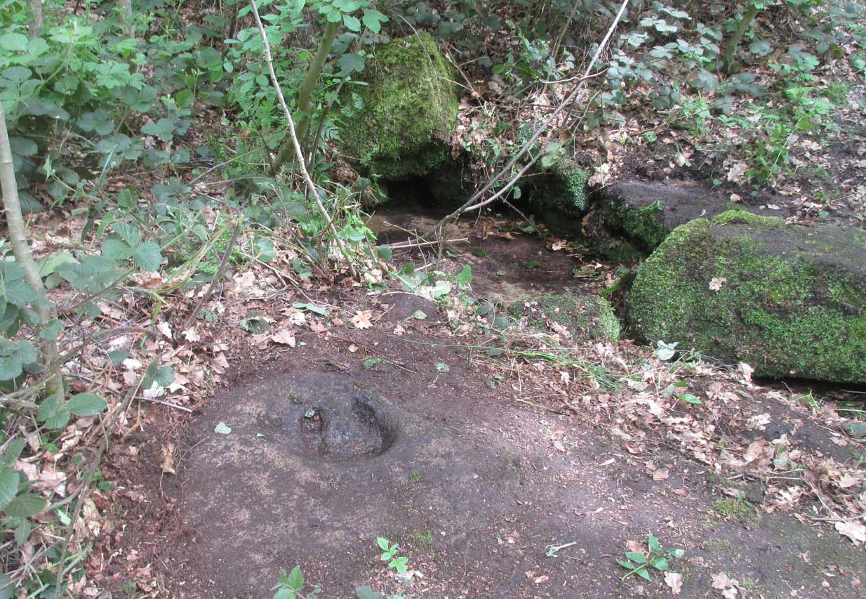
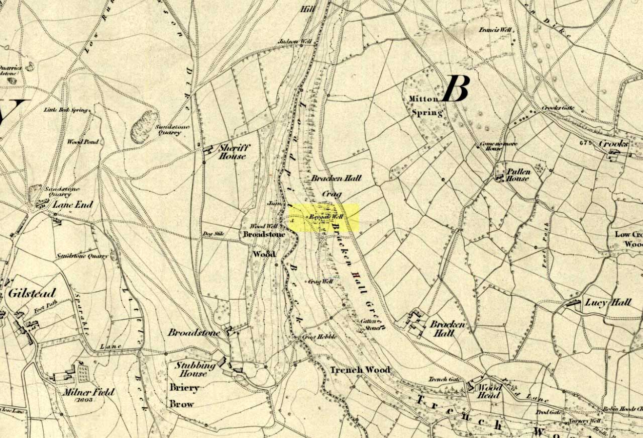
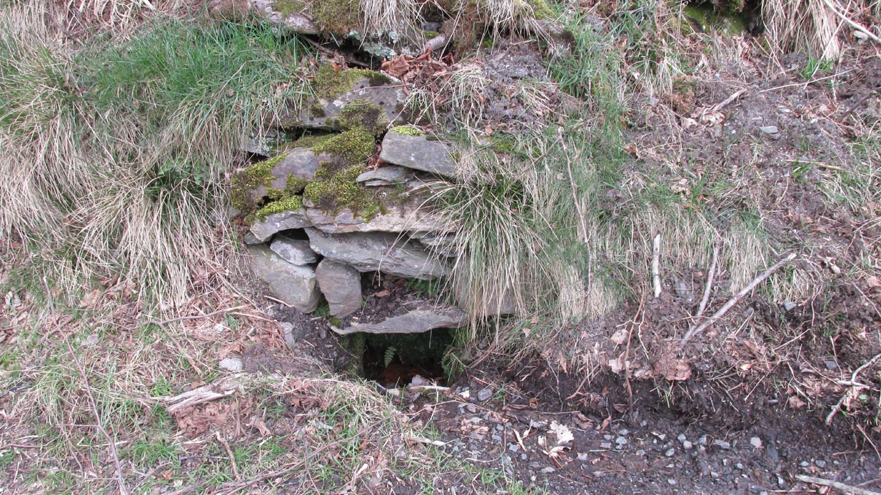
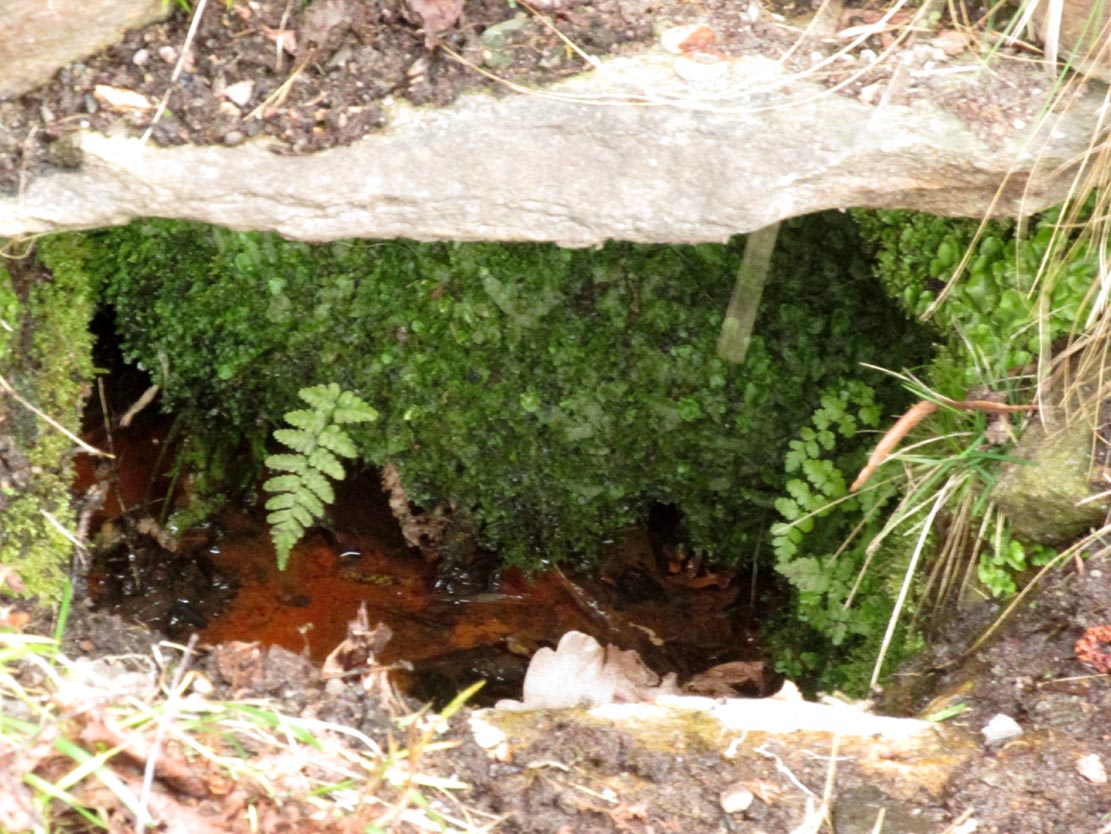
On the roadside at Shipley Glen, from Brackenhall Circlewalk up for about 250 yards, where you’ll notice the land dips as it drops into the woods below. Follow this dried stream down until you reach the mossy Loadpit Beck in the valley. By the waterside is a footpath: follow this upstream for a short distance, keeping your eyes peeled on the Earth below where a smaller stream crosses the path you’re walking on. Follow this uphill to its source!
Archaeology & History
Halfway up (or down) the moss-covered waters of Shipley Glen the all-but-forgotten waters of the Cloven Hoof Well still flows nice and freely, and is still good to drink. It was shown on the first OS-map of the area in 1852, where it was called the Raygate Well, whose derivation neither the great Baildon historian W. Paley Baildon nor the place-name giant A.H. Smith could account for. It sounds just like it was someone’s surname, but local genealogy cannot affirm this. One possibility—and which reflects in the local lore of the site—is that it’s a compound word from the old northern dialect word Rea, “an evil spirit or demon”, and gate, “a hole, an opening or gap.” The terms are used in a prayer given in Mr Sinclair’s Satan’s Invisible World Displayed (1814),
“as recited in the time of Popery by persons when going to bed, as a means of them being preserved from danger:
“Keep this house from the weir… And from an ill Rea, That be the gate can gae.””
But this purely speculative….
Cloven Hoof Well on 1852 map
A photograph and brief description of the Cloven Hoof Well was given in an early edition of the Bradford Scientific Journal after a geological excursion to Shipley, though nothing was said of its curious name. However on a rock below the spring, a hoof-print mark is clearly seen. It appears to be part-natural and partly enhanced. This is an area rich in prehistoric petroglyphs, or cup and rings stones.
Mosses thankfully still cover the rocks from whence the waters flow; and bilberry, blackberry, male fern and bracken also grow around it. Psychoactive plants also abound nearby. The water is healthy and never seems to dry up, even during long warm summers. And below here, on the other side of the stream at the bottom, you can visit the little-known Wood Well.
Folklore
Local lore told that the devil stepped here and left his hoof-mark in the rock, making the waters rise from the Earth. Possibly a venerated site in earlier days, one finds numerous ancient remains nearby (cup and rings, stone circle, walling, cairn fields). Pagans amongst you should love this place!
References:
Armitage, Paul, The Holy Wells and Healing Springs of West Yorkshire, forthcoming
Baildon, W. Paley, Baildon and the Baildons (parts 1-15), St. Catherines: Adelphi 1913-26.
la Page, John, The Story of Baildon, William Byles: London 1951.
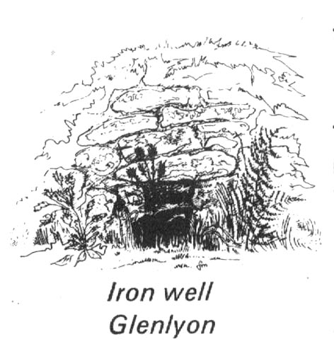
From Fortingall village, head west and turn down into the incredible beauty that is Glen Lyon. As you enter the trees, a half-mile along you pass the small gorge of MacGregor’s Leap in the river below. 2-300 yards pass this, keep your eyes peeled for an old small overgrown walled structure on the left-hand side of the road, barely above the road itself. A large tree grows up above the tiny walled enclosure, within which are the unclear waters that trickle gently….
Archaeology & History
In previous centuries, this all-but-forgotten spring of water wasn’t just a medicinal spring, but was one of the countless sites where sympathetic magick was practised. The old Highlanders would have had a name for the spirit residing at these waters, but it seems to have been lost. The site is described in Alexander Stewart’s (1928) magnum opus on this stunning glen, where he wrote:
“Still a few yards more and Glenlyon’s famous mineral wishing well is seen gushing up, surrounded by its wall of rough stones now sadly in need of repair. It has a stone shelf to receive the offerings of those who still retain a trace of superstition or like to uphold old customs as they partake of its waters. The offerings usually consist of small pebbles, but occasionally something more valuable is found among them. The roadmen may clear that shelf as often as they like, but it is seldom empty for long.”
A local lady from Killin told us that she remembers the stone above the well still having offerings left on it 20-30 years ago. Hilary Wheater (1981) sketched it and called it the Iron Well.
Close-up of the waters (photo by Paul Hornby)Hilary Wheater’s sketch
The waters in this small roadside well-house actually emerge some 50 yards up the steep hillside (recently deforested) and in parts have that distinct oily surface that typifies chalybeates, or iron-bearing springs – which this site is an example of. Its medicinal properties would help to people with anaemia; to heal women just after childbirth; to aid those who’d been injured and lost blood; as well as to fortify the blood and stimulate the system.
Across the road from the well, Stewart (1928) told of a giant lime tree that was long known to be the meeting place for lovers (perhaps relating to the well?), and the name of the River Lyon here is the Poll-a-Chlaidheamh, or ‘the pool of the sword’, whose history and folklore fell prey to the ethnic cleansing of the english.
References:
Stewart, Alexander, A Highland Parish, Alexander Maclaren: Glasgow 1928.
Wheater, Hilary, Aberfeldy to Glenlyon, Appin Publications: Aberfeldy 1981.