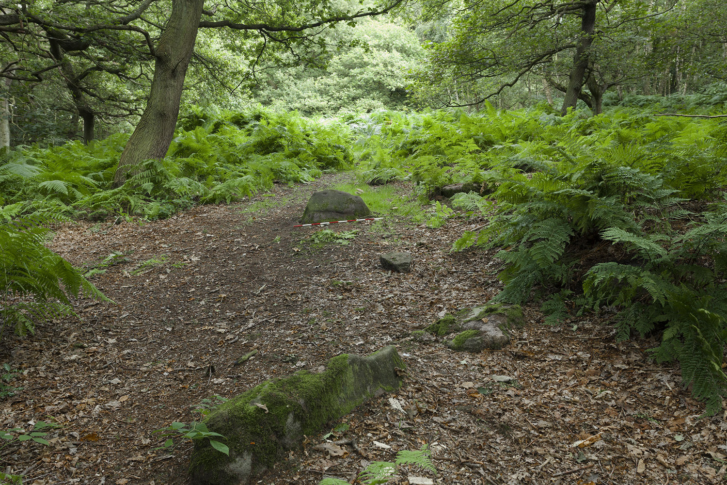
Mike Short tells: Walk ENE along Thornhill Drive (no vehicular access) to gate across road at the last house on the Drive and continue on for approx 475m where road starts to narrow slightly, becomes a little steeper and gently turns to E. Thornhill Drive is now cut into the hillside at this point with an upwards sloping bank on the S side of the path. After approx 25m further on at approx SE 20375 37950 look out on the S side of the path for a pile of boulders sitting on bedrock on top of the bank and a large rectangular tabular rock on the side of the bank. Ascend the bank and from the boulder pile the panel is approx 22m 200º(T) in the middle of an ephemeral E-W path more defined to W.
Archaeology & History
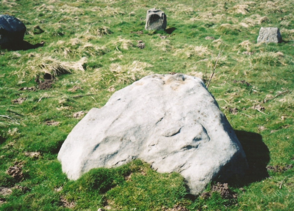
The profile (and ‘How to Get There’) for this recently discovered cup-marked stone was forwarded to me by fellow rock art explorer, Mike Short. The carving is another basic design found in Calverley Woods, between Leeds and Bradford, nearly halfway between the missing petroglyphs of West Woods 2 and Sidney Jackson’s Calverley Woods Stone. Rediscovered by Lisa Volichenko some time ago, Mike described the new carving here as follows:
Sketch of the carving (courtesy Mike Short)Cup-Marked Stone nr centre (courtesy Mike Short)
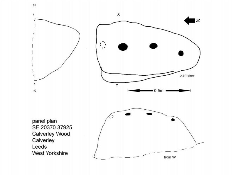
“Panel is carved on W sloping face of a sub-triangular earthfast coarse-grained sandstone boulder 0.81m X 0.50m X 0.38m, the longest axis lying almost exactly N-S. Carving consists of 3 cups, the most N of which is elliptical approx 65mm X 55mm; the central cup is elliptical approx 50mm X 40mm and the most S is circular diameter approx 40mm. On the N edge of the W face is a shallow elliptical depression thought to be of natural origin. There is an area of damage along the ‘crest’ of the boulder close to its S end.
“Carved rock is the most E of five rocks, measuring between 0.70m and 1.15m in length, in very close proximity forming an arc, 3 of which are in the footpath and one of which is resting on a large slab of rock almost completely covered by soil and vegetation.”
And so the small number of cup-marked stones in this woodland slowly grows. One wonders how many more are hidden beneath the roots of the trees—and are all of the lines and cups atop of the great Hanging Stone, a short distant away, all Nature’s handiwork…?
Acknowledgements: Huge thanks for Mike Short for the data, photos and sketch of this carving.
Take the A59 road from Harrogate and Skipton and at the very top of the moors near the Gill Head Enclosures, take the small Kex Ghyll road up past the disused quarry works north for a mile or so. At the junction go left, past the Outdoor Centre, thru West End up Whit Moor Road, then go left down to Brays Cross Farm and over the ford. Note the clump of trees on the moors to the west and take the path there. Once here, a large outcrop of rocks will be seen about 150 yards on the moor to the west. That’s the spot! Otherwise, follow the directions of the legendary wandering Teddy!
Archaeology & History
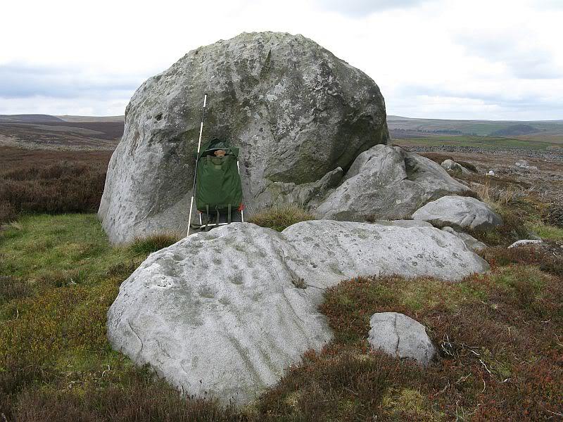
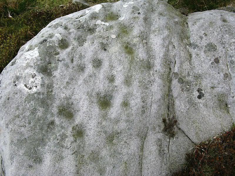
This dramatic looking outcrop of rocks rising out of the ground a half-mile due west of Bray farmhouse has long been known as the rocks of the ravens: oracular birds of ill-omen in all peasant traditions, yet carrier birds of shamans in their Underworld ventures, from accounts in Russia and Scandinavia, through the Scottish highlands and into Yorkshire’s northern hills, as folklore records show. Whether such mythical figures used the Raven Stones here for such magick, we have no firm accounts; but the existence of the many cup-markings on this particular rock (and others in the outcrop) show that animistic traditions of some form or another occurred here in prehistoric times at the very least.
Looking across the stoneLooking down on the cups (after QDanT)
Records of this place as an archaeological spot are scant indeed. It is passed with barely a mention by those Victorian antiquarian giants, Bogg, Grainge and Speight. The rock art students Boughey & Vickerman (2003) give the wrong grid reference here, but added the site to their inventory, saying only that it is “long, low, exposed bedrock. 22-25 cups; some very weathered and smooth.” A series of channels runs down the slope of the stone, but there are probably natural. However, a cup-and-line does occur on the eastern side of the carving.
References:
Armstrong, Edward A., The Folklore of Birds, Collins: London 1958.
Boughey, Keith & Vickerman, E.A., Prehistoric Rock Art of the West Riding, WYAS: Wakefield 2003.
Take the B6265 east out of Grassington, thru Hebden, for another 2 miles till you pass the tiny road down to Skyreholme on the right. Another few hundred yards on, past Nussey Farm and Dry Gill house, park up and look for the track going south into the moors. Go down the track called Black Hill Road for a few hundred yards till y’ reach the gate on the right. A track bends downhill to the psilocybin-rich pastures of Nussey Green. Several hundred yards on, to the right-hand side of the track, we find this and its companions. Look around!
Archaeology & History
Quick sketch of design
This medium-sized, recumbent standing-stone-shaped boulder has perhaps fifteen cup-markings on it. It’s a plain carving with others of a similar ilk in the area. First described by Stuart Feather in 1970 as one of “two cup-marked rocks” he found when ambling around; in Boughey & Vickerman’s (2003) survey they give it the wrong grid reference, though describe it correctly as a “long flat rock of irregular outline (with) fourteen to sixteen cups.” A cluster of other carvings are nearby, though some have been destroyed through mining operations.
References:
Boughey, Keith & Vickerman, E.A., Prehistoric Rock Art of the West Riding, WYAS: Wakefield 2003.
Feather, Stuart, “Appletreewick, W.R.,” in Yorkshire Archaeological Register, 1969, Yorkshire Archaeological Journal, part 168, 1970.
Near the centre of this photo, the large ‘ring’ can be seen
From Midgley go west along Height Road and take the track up on your right, at the tree-lined bend, up Foster Clough and onto the moor as if you’re gonna go to Churn Milk Joan. As you reach the footpath at the quarries up the hill, go to the top of them and take the small footpath where the land levels-out and head east towards the walling. Just a hundred yards or so before the walling, keep your eyes peeled, cos you’re damn close!
Archaeology & History
Best seen when looking down from the slopes above, this is a fascinating site that is lucky to still be here! For just a few yards to the west are extensive quarry works that could easily have destroyed the place had they continued. But thankfully we have here a near-perfect circular enclosure: measuring roughly 27 yards in diameter east-west, and about 25 yards north-south, the circumference around the outer-edge is approximately 82 yards (75m). It has all the appearance of an overgrown henge monument, with an outer bank and inner ditch, then a central flat arena—and it may indeed be such a monument—but until we have a decent excavation of the site, we’ll stick to calling it a simple enclosure—which it is!
Eastern arc of bank & ditch
The outer bank is very much overgrown, but as it runs round and defines this site, it measures 1-2 feet high most of the way, except on the westernmost spot, where it seems there may be an ‘entrance’. The inner ditch is only a couple of feet deep, again all the way round the monument. The internal level of the site is pretty flat, like most henges; but there seems to be a small central ‘cairn’ of some sort in the middle. Again, this is very overgrown by our traditional moorland vegetation.
Aerial image, 2009Aerial image, 2006
So what is it exactly? An enclosure, a settlement, or even (as local research student John Billingsley once suggested) a henge? Tis difficult to say for sure without further and more detailed archaeological excavation. My estimate is that the site is either Bronze- or Iron-Age in nature, and is definitely an ‘enclosure’ of some sort. We have located other prehistoric sites on the slopes just above here to the north, like the Crow Hill cairn circle and accompanying tumulus, remains of a neolithic settlement and a number of other small single cairns that are only visible when the heather has been burnt back. If you intend to explore any of the ancient sites sites on this moor, check this one out!
References:
Bennett, Paul, The Old Stones of Elmet, Capall Bann: Milverton 2001.
From Ilkley, take the directions up to the Panorama Woods 232 carving. From here you can step from this rock over the stride onto the cup-marked carving 231b, and then go onto the next adjoining rock surface a little lower down. From here, you’ll see another mossy rock surface in front of you by a yard or two. That’s the one!
Archaeology & History
The three cup-markings
Here’s another simple cup-marked stone, probably only for the purists amongst you—although in visiting here please take into account the primary carving’s association with other more prominent designs that once existed only a few yards to the west where the houses now stand. There is also the cluster of other carvings right next to this stone. A prehistoric settlement was also in evidence adjacent to this carving which was destroyed in the latter half of the 19th century.
Close-up of the cupsJohn Hedges 1986 drawing
Described simply in John Hedge’s (1986) fine survey as a small “piece of rock with three clear cups and one depression.” Boughey & Vickerman’s (2003) survey added nothing more and merely copied the same words. For some reason or other (mebbe cos I’m simple!) I really like this otherwise innocuous design and its close simplistic relatives. It’s probably due to the trees amidst which the stones are found and the bright mosses on the rocks, giving the site a slightly extra sense of more living genius loci than others on the top of these moors, where the winds move the subtle spirits with greater ease.
19th century addition
If you step down and look at the vertical side of this stone, you’ll notice a more modern stylistic carving etched onto the surface. Not as deep as the prehistoric cups on the top, it seems probable that a local artist by the name of Ambrose Collins carved this on here (and other similar designs on other rocks nearby) in the late 19th century.
References:
Bennett, Paul, The Panorama Stones, Ilkley, TNA: Yorkshire 2012.
Boughey, Keith & Vickerman, E.A., Prehistoric Rock Art of the West Riding, WYAS: Wakefield 2003.
Hedges, John (ed.), The Carved Rocks on Rombalds Moor, WYMCC: Wakefield 1986.
Although now seemingly lost, it’s location is damn close to this: Along the A657 between Greengates and Bradford, where the New Line meets Carr Road, the dirt-track takes you into Calverley Woods, down Eleanor Drive. About 250 yards along (just before you get to the field on the left), take the footpath down the embankment towards the stream where it bends to the left and where the land levels out (don’t cross the stream). It’s somewhere round there!
Archaeology & History
This was one of two previously unrecognised carvings we came across sometime in 1985 (see West Woods 1 stone), when we were seeking out another missing carving in the same woods. It was clear and well-defined as the faded photo here shows; but having been back to try find it twice in the last two years in the hope of getting better photos, I’ve been unable to locate it. The carving was described in an article I did in an old earth mysteries magazine. It comprises simply of a large ring surrounding and enclosing two deep cups, which were linked to each other by a connecting carved line. Parts of the stone had been chipped in parts—including a section of the large ring— due to some industrial workings that had happened here in the past. Thankfully I managed to find the old photo and hopefully, perhaps, some local explorer could try and seek out where it’s hiding beneath the trees and other vegetation.
References:
Bennett, Paul, “The Undiscovered Old Stones of Calverley Woods,” in Earth no.2, 1986.
The great Yorkshire historian Harry Speight (1892) gave the directions for this place, which I’ve not located. On his walk down the southern side off Whernside, he told us to “follow the road which runs between Gunnerfleet and the white house at Winterscales, going under the long viaduct and round by Batty Wife Hole onto the main road at Ribblehead….” About 100 yards or so down the road, look over the walling into the field on the left-hand side. It’s there…..somewhere!
Archaeology & History
In an area that is pretty rich in prehistoric sites, one of our great Yorkshire antiquarians, Harry Speight (1892) seems to have described a site which our archaeologists have yet to get round to finding. He told that,
“nearer the wall there are indications of a rude, double circle, artificially formed of these dark weathered grits. The inner circle is about 20 yards in diameter and the outer one forms a narrow aisle surrounding it, with an outlet to the north; but some of the stones have been removed, probably to build and repair the adjoining fences. The situation is open and commands the country on all sides between the lofty moors and summits that hem in the dale-head. On the opposite side of the road are the remains of a couple of large cairns. They are presumably Danish. One was opened about a century ago (c.1790), and found to cover a rude stone coffin containing an entire human skeleton. The other large pile does not ever appear to have been examined. It is more than probable that many a furious battel has been waged here, as the possession of this prominent ridge, which dominates so many particular outlets, must have been of capital importance to every hostile tribe.”
Although the Victorian christian beliefs of ‘rudeness’ in everything and rampant hostile tribes, has long since subsided in the view of our ancestors. This area described by Speight does sound like an old burial ground. But from which age – and where now are the sites he described?
References:
Speight, Harry, The Craven and Northwest Yorkshire Highlands, Elliot Stock: London 1892.
From Bradford city centre go up Bolton Road (crossing the big A650 dual carriageway) until, a couple of hundred yards further you meet with, at an angle, Wapping Road on the right. Where these roads meet, note a small footpath going down into the trees on the Bolton Road side. Go down here till it bends to the right at the bottom. Walk along here for less than 100 yards, keeping your eyes peeled for the small stone-lined well above the path on your right.
Archaeology & History
The Spink Well was highlighted on the 1832 boundary commission report map of Bradford; then listed in the 1850 Tithe Awards; and of course featured on the earliest Ordnance Survey map a few years later. In 1788, below the spring itself, a Spinkwell House was built which advertised health-giving cold baths and used the waters from this well to supply people with its health-giving virtues. This Spink Well house also had a most curious history: the gravestones of those who died in the plague of 1645 were built into the walls of the well-house here! They were uncovered during the construction of Peel Park in the 19th century, a short distance away. Then, for a long time thereafter, the waters and the stonework surrounding this well fell into disrepair—especially when the Industrialists appeared in what was, at the time, the world’s centre for such people.
The muddy waters of the well
The name ‘Spink Well’ is the most common of all the wells named after animals in West Yorkshire (and elsewhere in Yorkshire for that matter), with ten examples of them that I’ve come across locally. The word ‘spink’ is the local dialect word for the finch. A veritable profusion of them scatter our region, although not much folklore is known about this little bird. The various types (gold finch, bull finch, etc) are all said to be birds of good fortune and one of its calls is said to tell of the coming of rain.
This particular Spink Well is very close to Bradford city centre and although now only a trickle of muddy water fills the trough into which it once ran freely, at least it’s still here! Many other sites close to the city centre were destroyed without care by the ignorant Industrialists. The well was evidently a place of some importance in ages past, as the 1852 OS-map shows eight spots hereby named after the place! The local historian Roger Storrs (1888) wrote that—along with the Holy Well Ash Well a short distance from here—these sites “were long ago famous wells.” No specific medicinal properties have been remembered for this place.
Folklore
Folklore tells that a huge boar—which gave its name to the Boar Well just 100 yards along the same path from here—also drank the waters here at Spink Well.
References:
Storrs, Roger, ‘Legends and Traditions of Wells,’ in J.H. Turner’s Yorkshire Folklore Journal, 1888.
Whelan, Edna & Taylor, Ian, Yorkshire Holy Wells and Sacred Springs, Northern Lights: Dunnington 1989.
Follow the directions to reach Panorama Woods carving 232. Barely a yard or two southwest across the small gap where the kids have their little den or hideout, this long curvaceous rock is the fella in question.
Archaeology & History
Cup-markings on the rock
Curiously not included in the ‘official’ records, this large piece of rock, living right in between the Panorama Woods carvings 231 and 232, has at least two, possibly three faint cup-marks etched in the top northeastern portion of the rock. Of the same style and probably period as the basic designs on stones 230 and 231, this is one in a cluster of petroglyphs that used to live at the edge of a prehistoric enclosure, destroyed at the end of the 19th century.
References:
Bennett, Paul, Of Cups and Rings and Things, unpublished: Shipley 1981.
Bennett, Paul, The Panorama Stones, Ilkley, TNA: Yorkshire 2012.
Take the Wells Road from Ilkley centre up towards White Wells, bending to the right as you hit the edge of the moor. Keep along the road, past the old college building with its lake and turn right up Westwood Drive. Keep going all the way up till you hit the small woodland on your right. Where the woodland ends – stop! Walk into the trees about 10-15 yards and you’ll see the large rocks ahead of you. Amongst other petroglyphs hereby, you’ll find this carving is on one of them.
Archaeology & History
Close-up of deep cups & grooves
Although only given the usual dry description by our academic catalogue chaps, there’s something about this design that I’ve always liked. We first came across it ourselves in the late 1970s, in search of the legendary Panorama Stones, and found instead this large enclosure design with at least three cups inside it, still clearly visible. It is one of a cluster of carvings hereby, all of which were once adjacent to a prehistoric enclosure, described in the 1880s and destroyed soon after. This and the associated carvings very probably had some archaeocentric relevance to the lost enclosure.
Large carved ‘enclosure’, recently chalkedDrawing of the carving (after Hedges 1986)
The carving is sandwiched in between its petroglyphic companions, stone 231 and stone 233. As can be seen on some of the photos here, more recent vandalism has been inflicted on this carving and the recent chalk colouring is what local archaeologists Gavin Edwards and Alex Gibson have termed “social history”, implying fallaciously that cup-and-ring art could be seen as little more than neolithic and Bronze Age scribblings on rock, without any meaning other than it being comparable to “Leeds United Rules OK.” They may be right (highly unlikely) – but in reading copiously about prehistoric petroglyphs in cultures beyond the UK, we find that traditional societies tell such carvings relate to their creation myths, or river spirits, or rock spirits, and are intrinsically related to wider animistic cosmologies and social customs. This indicates, to me at least, that modern archaeologists who think of rock art as little more than childish scribblings still have a great deal to learn and we should beware their uneducated musings about our ancient carvings.
Although the complete carved ‘enclosure’ and its internal cups were mistakenly drawn in John Hedges (1986) survey, he described as being a,
“Roughly incised ‘enclosure’ with five cups in it, twenty eight shallow cups or depressions, one large oval marking, three irregular basins.”
In the later work of rock art students Boughey & Vickerman’s (2003), they simply said of the site:
“Large flat-topped, upstanding rectangular rock. Twenty-eight shallow cups, a few enclosed in two groups by grooves; irregular small basins.”
References:
Bennett, Paul, Of Cups and Rings and Things, unpublished: Shipley 1981.
Bennett, Paul, The Panorama Stones, Ilkley, TNA: Yorkshire 2012.
Boughey, Keith & Vickerman, E.A., Prehistoric Rock Art of the West Riding, WYAS: Wakefield 2003.
Hedges, John (ed.), The Carved Rocks on Rombalds Moor, WYMCC: Wakefield 1986.