Holy Moor, Holymoorside, Derbyshire

Cup-and-Ring Stone:  OS Grid Reference – SK 3211 6866

Getting Here

The stone in question!

From Holymoorside, take the long straight Loads Road running west out of the town into Longside Road. ¾-mile along, past Home View and just before Well Lane (on the right), there’s a public footpath sign pointing into the fields on your left. Walk dead straight, dead south along the wallside for 450 yards, then walk straight left again along the other wall until you reach the tiny bit of moorland less than 150 yards away.  The carved rock is just on the other side of the stile at the edge of the old walling.  You’ll find it.

Archaeology & History

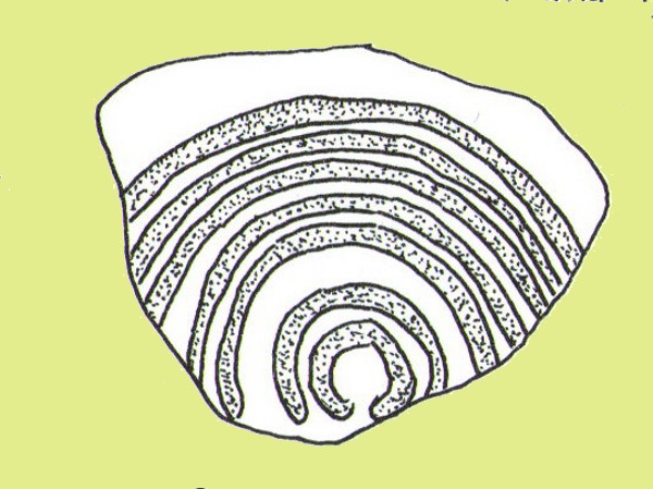
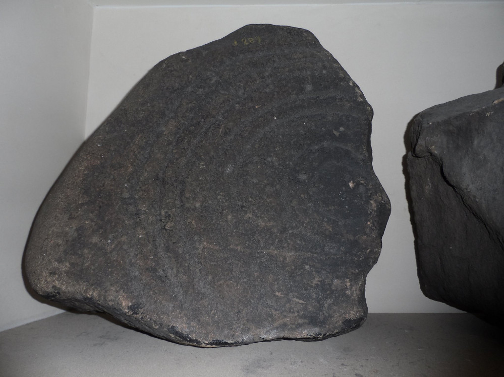
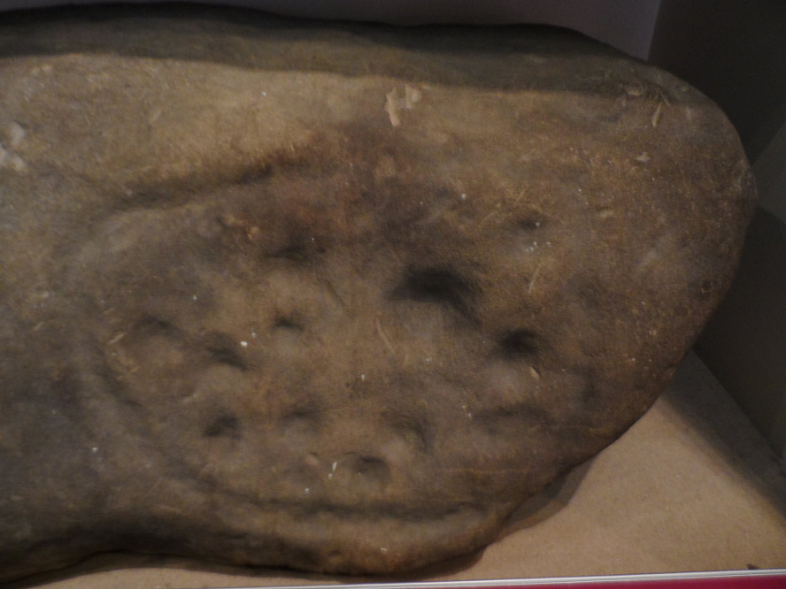
Rediscovered sometime in 2002, this would seem to be an isolated cup-and-ring stone.  It was first mentioned in John Barnatt’s (2003) short gazetteer of Peakland petroglyphs, where he wrote,

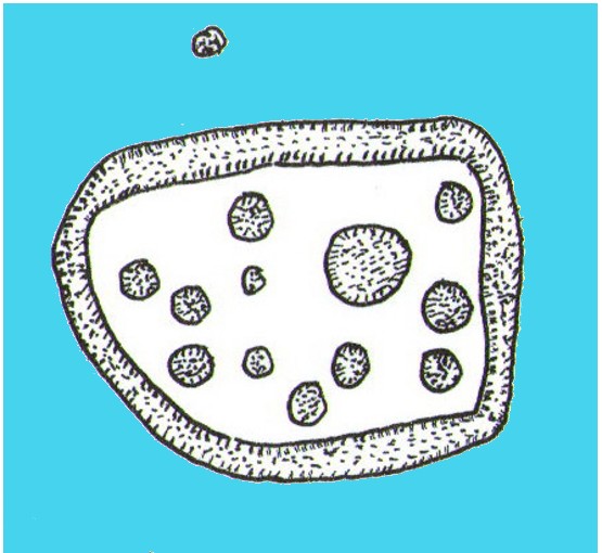
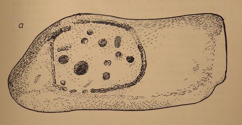
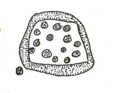
“This irregularly-shaped small boulder was identified recently lying amongst post-medieval field clearance adjacent to a field corner and footpath… Its upper parts ar covered with 40-46 cupmarks.  On the exposed irregular top they are badly worn and sometimes uncertainly identified.  In one instance a cup is partly encircled by a worn ring, while a second partial ring nearby may be fortuituous.  On a ledge near one edge of the boulder preservation is better and the cups are clearly defined and densely arranged.”

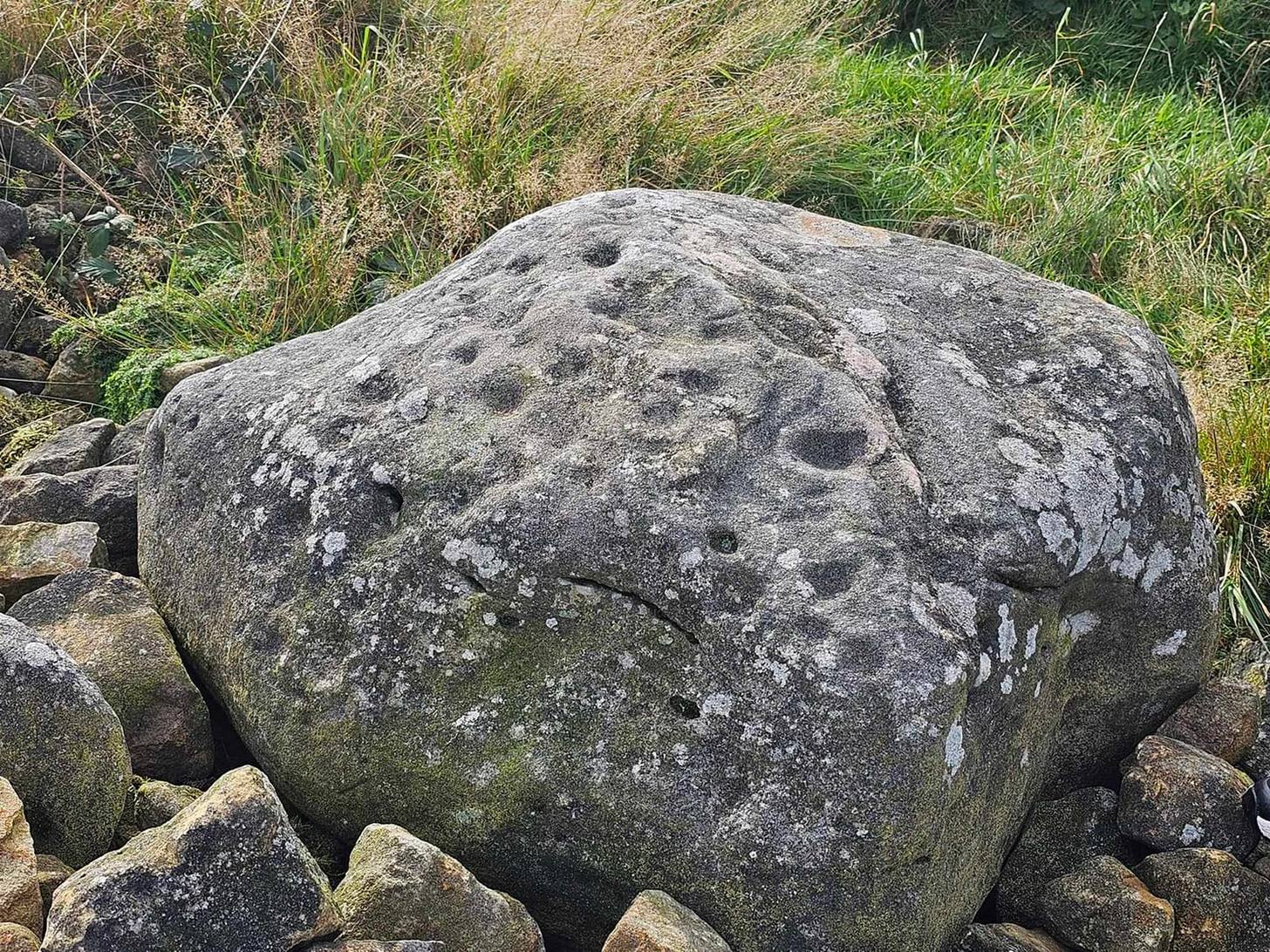
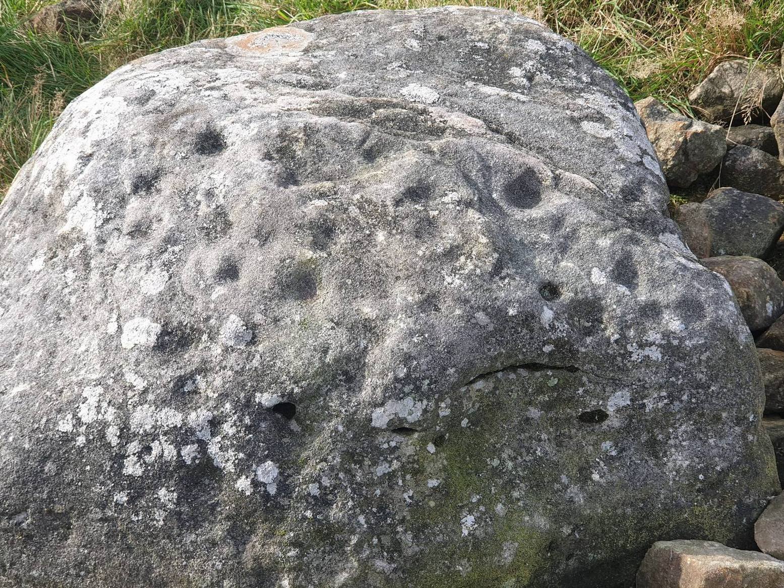
The stone looks as if it’s been moved into its present location, obviously for use in the walling.  It’s original position would have been somewhere close by, but we know not where that might be.

References:

  1. Barnatt, John & Robinson, F., “Prehistoric Rock Art in Ashover School and Further New Discoveries Elsewhere in the Peak District,” in Derbyshire Archaeological Journal, 123, 2003.

Links:

  1. Pecsaetan – Holymoorside Cup-and-Ring Marked Boulder 

Acknowledgements:  Huge thanks to Geoff Watson for use of the photos in this site profile.  It wouldn’t have been written without them.

© Paul BennettThe Northern Antiquarian

Holland’s Well, Smalley, Derbyshire

Healing Well:  OS Grid Reference – SK 4077 4436

Also Known as:  

  1. Holly Well

Archaeology & History

Hollands Well on 1881 map

Once visible near the middle of the village, references to this local water supply seem pretty scant.  According to Kenneth Cameron (1950) it gained its name from a local man called Robert Holland.  This may be the case; but there is a curious entry found in a notice regarding the Land Enclosures of Smalley from November 6, 1784.  In it we read that the land here was at that time owned by one Samuel Kerry (well known in the village as he built The Rose and Crown pub in 1768) who was living “upon the Common” and had “part of a croft” here.  Therein was mentioned a water source named the ‘Holly Well’ instead of the Holland Well.  I can only assume that the two are the same, as the proximity of them are very close indeed.  The account told that,

“a disused well in the triangular croft at the back of the sixth milestone in the village marks the site of (Samuel Kerry’s) original home, and he is said to have dug the “Holly Well” close by for brewing purposes, which has long supplied the vicinity with good water.”

The name ‘Holly’ may infer that a holly tree grew by the side of the well, and that the title ‘Holland’ was a corruption later grafted onto the site.  Are there any local historians out there who know more…?

References:

  1. Cameron, Kenneth, The Place-Names of Derbyshire – volume 2, Cambridge University Press 1950.
  2. Kerry, Charles, Smalley in the County of Derby, Bemrose: London 1905.

© Paul BennettThe Northern Antiquarian


St John’s Well, Dronfield, Derbyshire

Holy Well:  OS Grid-Reference  SK 353 783

Getting Here

St Johns Well, Dronfield

St Johns Well, Dronfield

In Dronfield, St. John’s Well is to be found off Church street in the Forge in the courtyard adjacent to the glass roofed atrium on the left hand side.

Archaeology & History

J.C. Cox (1875–9) in his Churches of Derbyshire appears to the sole reference although he quotes a lost 1710 reference.  He notes a St. John’s Well cited by Francis Bassano, c.1710, saying:

“…a well, close to the churchyard in St John’s Lane, called St John’s Well, from which “they usually fetch water now for baptising infants””.

Looking down the well...

Looking down the well…

...and into the waters

…and into the waters

Despite only this slight mention, the site still survive.  According to local historian Mr. Ken Ward, the well is that now found in the courtyard of the forge: a 16th century building now developed into a small shopping complex.  He states it is 80 metres from the south porch of the church supporting Bassano’s location.  The site is along Church Street (previously Church Lane) which he believes was once called St. John’s Lane. The well is a circular one with modern stonework on the top.  However, this encloses a much older ring of six layers with a grill apparently opening out into a larger chamber below.  It appears to be a deeper well than would be expected, but it is spring-fed and was presumably deepened for use in the forge.

References:

  1. Cox, J. Charles, Notes on the Churches of Derbyshire – volume 1, Palmer & Edmonds: Chesterfield 1875.

Cratcliff West Enclosure, Harthill, Derbyshire

Enclosure:  OS Grid Reference – SK 2259 6238

Getting Here

Site of Cratcliff West enclosure

Site of Cratcliff West enclosure

Taking the roughly north-south road betwixt the village of Elton and the town of Youlgreave, rising up to see the great rock outcrop of Robin Hood’s Stride, park-up by the roadside and walk down the path towards the impressive rocky rise of Robin Hood’s Stride.  Keep to the fields below the Rise on its north side and head for the next wooded rise 2-300 yards west.  In the field you’ll cross (field number 202 in on the map, right) before this wooded crag [Cratcliffe Rocks], the outline of the enclosure is beneath your very feet.

Archaeology & History

Aerial image of the Ninestone Ring enclosure

Aerial image of the Ninestone Ring enclosure

This blatantly obvious oval-shaped enclosure or settlement ring has had very little said of it in archaeological circles as far as I can tell. (please correct me if it has!)  I found it quite fortuitously during aerial surveys of the nearby Nine Stones circle.  It’s certainly quite large.  With a general circumference of roughly 285 yards (260.5m), the relative diameters of this enclosure are—from north to south—91 yards (83m) and—east to west—80 yards (73.25m).  The ditch alone is quite wide all the way around, almost giving it a ‘henge’ quality.  Its southern section is nearly 10 yards across at one point!

The northwest section of the enclosure has been built into, or upon a small natural outcrop of rocks.  But also at this point—as seen clearly in the aerial photo—on the other side of the wall just past the raised natural outcrop, is a long straight parallel linear feature, very probably man-made, running away to the northwest for at least 174 yards (159m).  It too is quite large, averaging  more than 13 yards (12m) across all along the length of this “trackway”: twice as wide as the nearest road and similar in form to the smaller cursus monuments that scattered neolithic Britain.

The site seems to be typical in form and structure to general Iron Age, or perhaps late Bronze Age settlements – but without a proper ground appraisal, this is a purely speculative appraisal.  Any further information or images of this site to enable a clearer picture of its nature would be most welcome.

Acknowledgements:  With thanks in various way to Pete Woolf, Dave Williams, Geoff Watson & Martin Burroughs.

© Paul BennettThe Northern Antiquarian 


Nanny’s Well, Chapel le Frith, Derbyshire

Holy Well:  OS Grid-Reference – SK 061 810

Getting Here

Nanny's Well, Chapel-le-Frith
Nanny’s Well, Chapel-le-Frith

To find Nanny’s Well, take B5474 out of Chapel and take the right hand turning called Crossings road (which goes to Chinley) which is before Frith view on the left. Continue until the small wall surrounding the site can be seen on the right.

Archaeology & History

The name it is said to be either from St Ninian (less likely) or St Anne (more likely as she is also considered the mother of Mary and thus Grandmother of Jesus).

copyright Pixyled
The Nanny well pump


It is described in M.J.B Baddeley’s Peak district of Derbyshire (1913) and the neighbourhood as:

“a valuable but neglected spring of chalybeate water.”


Yet in 1895, a Manchester firm of Grace, Calvert and Thompson  analysed it and found it:

“not polluted to any extent with organic matter of animal or vegetable origin and comes from a spring of considerable depth and that no surface water has become mixed with it’…in same respects the water of this well is of the same nature as that from the Tunbridge Wells springs.”

The site is now an iron pump by the side of Crossings Road, known as Nanny Well Road, enclosed in a low wall along which. The pump no longer works and the well capped but it can be heard and just about seen through a crack beneath.

Copyright Pixyled
A peer through the crack shows running water!

Folklore 

copyright Pixyled
Nanny well plaque

It was visited on Easter Morning, with sugar or licorice to make Spanish Water, and then the bottles were hung around their necks. The site is one of four wells dressed annually since the 1980s in July and the site is blessed.

Extracted from Parish, R. B., (2008) Holy Wells and Healing springs of Derbyshire

http://insearchofholywellsandhealingsprings.wordpress.com

© R.B. Parish, The Northern Antiquarian


Holy Well, King’s Newton, Derbyshire

Holy Well:  OS Grid Reference – SK 386 262

Getting Here

The well depicted in Hope’s (1893) Legendary lore of holy wells, sadly he says nothing about it!

The Holy Well is signposted off the road to Castle Donington on the left hand side as you near a small brook, past new bridge and it will be seen down the track. It can be muddy, so bring some boots!

Archaeology & History

It is first noted in 1366 as ‘Halywalsiche.’  The purchase of the lands of St Catherine’s Chantry, lately dissolved, in 1564, refers to lands here at ‘Holy well hedge’ and ‘Hollywell siche.’  A carved inscription over the well read:

Fons sacer hic strvitvr Roberto Nominus Hardinge 16xx

translating as:

this Holy well was built by Robert named Hardinge 16xx“.

Briggs suggested the date of 1660, which is quite likely, as it coincides with the Restoration of Charles II as the family at the nearby hall.  The aforementioned Hardinge, were staunch Royalists, and of course puritans disliked holy wells as many other so called ‘popish’ things. However, its restoration may have been for little more than to maintain a good water supply. Later depictions such as pre-war postcards show the date to be quite clearly 1662.

The restored holy well today, original stonework to rear with newer stone at the front

The present condition of the well is tribute to its local community.  The arch survived for nearly 300 years but a combination of vandals and the roots of the nearby ash tree caused the arch fall down and it lay in pieces in the 1950s. Sadly the original inscription appears to have been stolen or entirely broken to pieces. However, unlike many similar sites, this was not the final fate of the well. In the 1980s it was restored using as many of the old stones as possible. The landowner was happy to sell the land and Melbourne Civic Society donated money for its restoration. No artifacts were found, apart from 17th century Ticknall ware pottery, later tiles, and drainpipes fragments. Most of the original stones were recovered, but the job of reconstructing them appeared to be a large task and new stone was required. The arch over the well was left blank as it was thought misleading to re-inscribe it. Usher (1985) notes that on the first Sunday after Ascension Day, May 19th 1985, over a hundred people gathered for the opening ceremony when the plaque was unveiled by the Society’s President, the Marquees of Lothian, of Melbourne Hall. It is delightful to see it restored and celebrated by the community.

Folklore

There appears to be no records regarding its properties baring its ‘superior excellence of its waters‘, and being noted as a mineral spring. Interestingly, its waters are said to flow towards the rising sun.

Extracted from R.B.Parish’s (2011) Holy wells and healing springs of Derbyshire

References:

  1. Usher, H., (1984) The Holy Well at King’s Newton, Derbyshire. Old Series Source

© R.B. Parish, The Northern Antiquarian


St. Alkmund’s Well, Derby, Derbyshire

Holy Well:  OS Grid Reference – SK 351 371 

Geting Here

It can be found by taking North Street off Duffield Road (A6) continuing until it joins North Parade and here a little lane, called Well Street comes off and the spring is at the junction of this and Bath Street on the left hand side.

Archaeology & History

St. Alkmund's Well, Derby
St. Alkmund’s Well, Derby

First recorded in 1190 in a rental agreement but considering its association probably earlier. The well is dedicated to the Saxon saint who died 800 AD and whose tomb or shrine was located in church nearby (and is now located in the Derby Museum).  Little is recorded of its history however.

The well is below ground level with four steps to its water which flows with some force into an oval basin. A stone carving states its name. The plaque reads:

“Until the area was built up from 1814, the well was in a rural setting, part of St Helen‟s Park. The stone niche surrounding the well was built by the Rev Henry Cantrell in the early 18th century”.

It now sits rather incongruously in an area of urban landscape,  an odd juxtaposition amongst the older houses and tower blocks still exists, but is often prone to vandalism. and has suffered from it. Well dressings were discontinued due to vandalism and it was blocked off my tall metal fencing for a period recently. Now it is surrounded by a small wall and black railings which has blocked access but will protect it.

Folklore

Cox (1875–9) records that a vicar of S. Werburgh’s was cured of his low consumption, after constantly drinking its water, although the sign It has been traditionally dressed, revived in 1870 and continued infrequently until 1993, stopping because the boards were thoughtlessly vandalised. The demolishing of the St. Alkmund’s Church in the 1960s for road widening stopped the tradition of processing to the well. I was told by a local elderly lady that she still drank the water and that it was very pure…I was not sure myself!

References:

  1. Parish, R.B, (2010) Holy Wells and Healing Springs of Nottinghamshire

Copyright © Pixyled Publications


Ball Cross Carving 02, Bakewell, Derbyshire

Cup-and-Ring Stone:  OS Grid Reference – SK 231 691

Archaeology & History

Ball Cross 2 Carving (after Beckensall)

One of three carvings that were located inside the walling of the Ball Cross hillfort during excavations here in the early 1950s by J. Stanley. (1954)  Each carving is distinctly unlike the other in design (see Ball Cross 1 and Ball Cross 3) and it’s highly probable that they were incorporated into the Iron Age structure with their original mythic functions—of neolithic or Bronze Age origin—disused. It is not unlikely that this and its compatriots were originally found in association with the nearby prehistoric tombs.

Ball Cross 2 Carving (photo by Dean Thom)

The broken piece of rock consists of a broken section of an almost archetypal ‘cup-and-ring’—although with this design, no central ‘cup’ occurs: a pattern found at several other multiple-ring stones, like the Grey Stone near Leeds.  Although Stan Beckensall (1999) described this to have “8 concentric rings”, his drawing and the photo here by Dean Thom, clearly show only seven such ‘rings’.  The carving presently lives in a protective box in Sheffield Museum (though beware the listing they give of the designs, as some are incorrect).

References:

  1. Barnatt, John & Reeder, Phil, “Prehistoric Rock Art in the Peak District,” in Derbyshire Archaeological Journal, 102, 1982.
  2. Beckensall, Stan, British Prehistoric Rock Art, Tempus: Stroud 1999.
  3. Beckensall, Stan, Circles in Stone: A British Prehistoric Mystery, Tempus: Stroud 2006.
  4. Cooper, Ali, Archaeology Walks in the Peak District, Sigma: Wilmslow 2010.
  5. Morgan, Victorian & Paul, Rock Around the Peak, Sigma: Wilmslow 2001.
  6. Stanley, J., “An Iron Age fort at Ball Cross Farm, Bakewell,” in Derbyshire Archaeological Journal, volume 74, 1954.

Acknowledgements:  HUGE thanks to Dean Thom for the use of his photo, plus helpful references on this site.

© Paul Bennett, The Northern Antiquarian


Ball Cross Carving 01, Bakewell, Derbyshire

Cup-and-Ring Stone:  OS Grid Reference – SK 2310 6911

Archaeology & History

Ball Cross 01 Carving (photo © Dean Thom)

This is another carving (one of three here) that was removed from its landscape setting when found during excavations of the Iron Age hillfort of Ball Cross in the 1950s, and then placed into a box in Sheffield Museum, decontextualizing it and leaving future researchers slightly in the dark as to its possible nature.  In removing the carving from its site, the stone was left with additional scratches and grooves slightly damaging the stone.  Not good!

Ball Cross Carving (after Beckensall)
Ball Cross Carving (after A. Cooper)

Although unlike the Ball Cross 2 and 3 carvings, the design here is structurally very similar to that found east of Gardoms Edge, with this one comprising of a large unbroken carved oval, with at least twelve cup-marks inside.  Or as Beckensall (1999) described, it “has 12 cups inside a flattened ring.”  Again, like the Gardoms Edge carving, a single cup-mark was etched outside of the enclosed ring. It was found with its companion carvings built into the main walled structure of the hillfort.  It’s unlikely that the stones date from the same age as the hillfort: more probable that they were re-used in the structure, with their mythic nature perhaps already long forgotten…

References:

  1. Barnatt, John & Reeder, Phil, “Prehistoric Rock Art in the Peak District,” in Derbyshire Archaeological Journal, 102, 1982.
  2. Beckensall, Stan, British Prehistoric Rock Art, Tempus: Stroud 1999.
  3. Beckensall, Stan, Circles in Stone: A British Prehistoric Mystery, Tempus: Stroud 2006.
  4. Cooper, Ali, Archaeology Walks in the Peak District, Sigma: Wilmslow 2010.
  5. Morgan, Victorian & Paul, Rock Around the Peak, Sigma: Wilmslow 2001.
  6. Stanley, J., “An Iron Age fort at Ball Cross Farm, Bakewell,” in Derbyshire Archaeological Journal, volume 74, 1954.

Acknowledgements:  HUGE thanks to Dean Thom for the use of his photo, plus helpful data on this site.

© Paul Bennett, The Northern Antiquarian


Gardoms Edge 02, Baslow, Derbyshire

Cup-and-Ring Stone:  OS Grid Reference – SK 2752 7328

Archaeology & History

Gardoms Edge 2 carving, in Sheffield Museum (photo - Dean Thom)
Gardoms Edge 2 carving, in Sheffield Museum (photo – Dean Thom)

This carving is one of two cup-and-ring stones that were removed from this area and transported to Sheffield Museum, decontextualizing them from their landscape presence (this should not be done unless very severe damage is happening, or their destruction is imminent).  It’s quite an intriguing carving, similar in design to one found not far away at Great Hucklow, the Middleton Moor 479 carving, etc.  Like many Pennine cup-and-ring stones, it was located in a prehistoric cairn field (or necropolis), with hut circles not far away too, and really should have remained in situ for the benefit of future researchers.

Gardoms Edge carving (after Beckensall 1999)

The carving was cut into one end of a small rock and comprises of a singular unbroken, large oval, within which are enclosed thirteen or fourteen cups, plus a single cup on the outside of the ring.  Lunar associations may be invoked by the 13 cups, enclosed within one cycle of the year.  But I’m speculating of course.  It’s probable that other carvings in the area remained undiscovered.

References:

  1. Barnatt, John & Reeder, Phil, “Prehistoric Rock Art in the Peak District,” in Derbyshire Archaeological Journal, 102, 1982.
  2. Barnatt, John & Robinson, F., “Prehistoric Rock Art in Ashover School and Further New Discoveries Elsewhere in the Peak District,” in Derbyshire Archaeological Journal, 123, 2003.
  3. Beckensall, Stan, British Prehistoric Rock Art, Tempus: Stroud 1999.
  4. Beckensall, Stan, Circles in Stone: A British Prehistoric Mystery, Tempus: Stroud 2006.

Acknowledgements:  HUGE thanks to Dean Thom for the use of his photo here.

© Paul Bennett, The Northern Antiquarian