Cup-Marked Stone (missing): OS Grid Reference – SE 16940 87301
Archaeology & History
A prehistoric carving that is missing and possibly destroyed since being rediscovered in 2001 by Barbara Brown (2008) and subsequently described in her book on North Yorkshire petroglyphs. She told it to be in “Thornton Steward field hedge bottom” and was a simple glyph, being a
“rectangular slab (with) single cup-mark located in hedge bottom part of old walling.”
When she revisited the site with her husband in 2006, the old hedge and wall had been removed, with “new hedging in place.” The carved stone may be buried within a pile of clearance stones adjacent to the hedgerow, but it has yet to be relocated. If anyone finds it, please let us know! It was one of several cup-marked stones that exist in the wider neighbourhood.
References:
Brown, Paul & Barbara, Prehistoric Rock Art in the Northern Dales, Tempus: Stroud 2008.
The well depicted in Hope’s (1893) Legendary lore of holy wells, sadly he says nothing about it!
The Holy Well is signposted off the road to Castle Donington on the left hand side as you near a small brook, past new bridge and it will be seen down the track. It can be muddy, so bring some boots!
Archaeology & History
It is first noted in 1366 as ‘Halywalsiche.’ The purchase of the lands of St Catherine’s Chantry, lately dissolved, in 1564, refers to lands here at ‘Holy well hedge’ and ‘Hollywell siche.’ A carved inscription over the well read:
“Fons sacer hic strvitvr Roberto Nominus Hardinge 16xx“
translating as:
“this Holy well was built by Robert named Hardinge 16xx“.
Briggs suggested the date of 1660, which is quite likely, as it coincides with the Restoration of Charles II as the family at the nearby hall. The aforementioned Hardinge, were staunch Royalists, and of course puritans disliked holy wells as many other so called ‘popish’ things. However, its restoration may have been for little more than to maintain a good water supply. Later depictions such as pre-war postcards show the date to be quite clearly 1662.
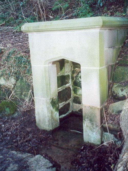
The restored holy well today, original stonework to rear with newer stone at the front
The present condition of the well is tribute to its local community. The arch survived for nearly 300 years but a combination of vandals and the roots of the nearby ash tree caused the arch fall down and it lay in pieces in the 1950s. Sadly the original inscription appears to have been stolen or entirely broken to pieces. However, unlike many similar sites, this was not the final fate of the well. In the 1980s it was restored using as many of the old stones as possible. The landowner was happy to sell the land and Melbourne Civic Society donated money for its restoration. No artifacts were found, apart from 17th century Ticknall ware pottery, later tiles, and drainpipes fragments. Most of the original stones were recovered, but the job of reconstructing them appeared to be a large task and new stone was required. The arch over the well was left blank as it was thought misleading to re-inscribe it. Usher (1985) notes that on the first Sunday after Ascension Day, May 19th 1985, over a hundred people gathered for the opening ceremony when the plaque was unveiled by the Society’s President, the Marquees of Lothian, of Melbourne Hall. It is delightful to see it restored and celebrated by the community.
Folklore
There appears to be no records regarding its properties baring its ‘superior excellence of its waters‘, and being noted as a mineral spring. Interestingly, its waters are said to flow towards the rising sun.
Access to these stones has, over recent years been pretty dreadful by all accounts. It’s easy enough to locate. Go into Calderstones Park and head for the large old vestibule or large greenhouse. If you’re fortunate enough to get one of the keepers, you may or may not get in. If anyone has clearer info on how to breach this situation and allow access as and when, please let us know.
Archaeology & History
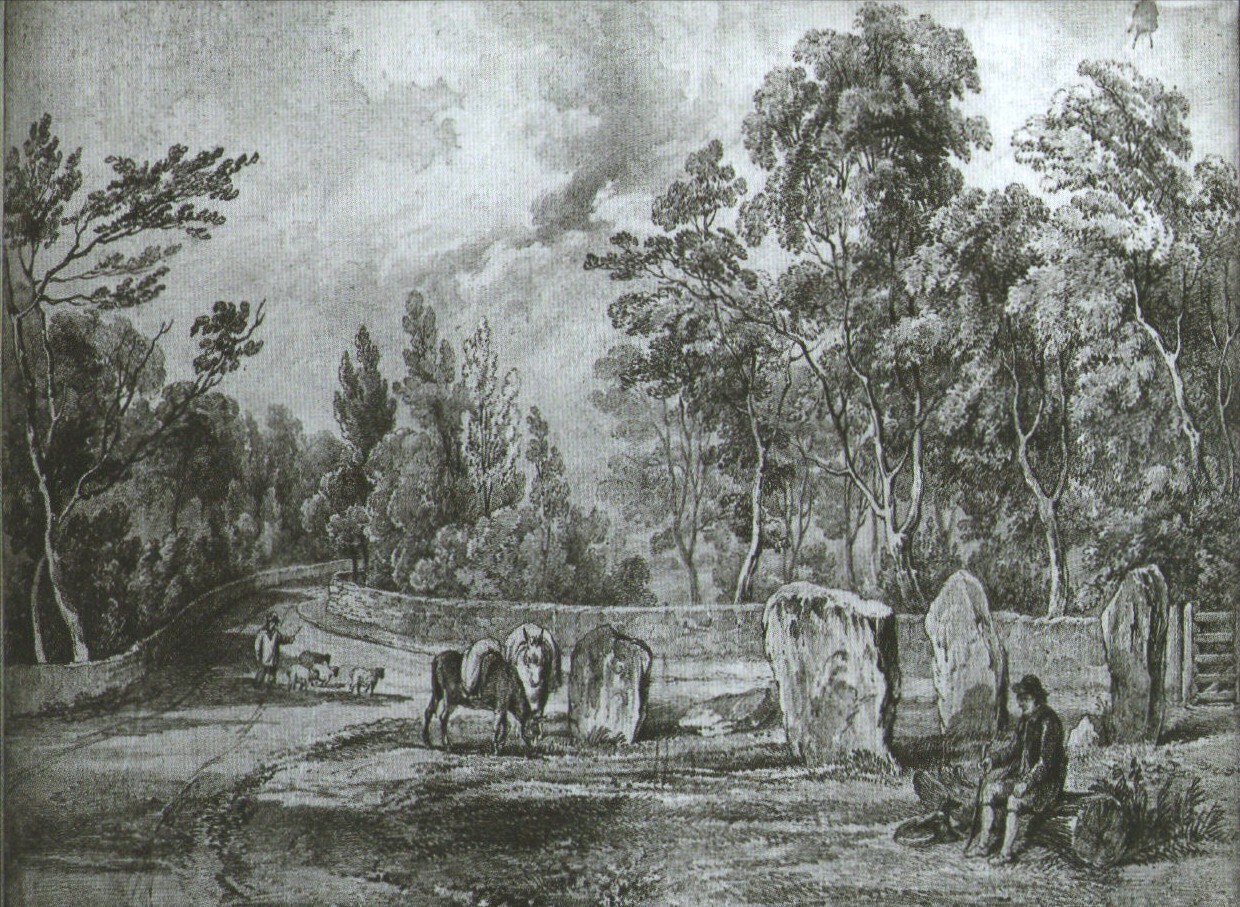
Earliest known drawing from 1825, showing the carvings
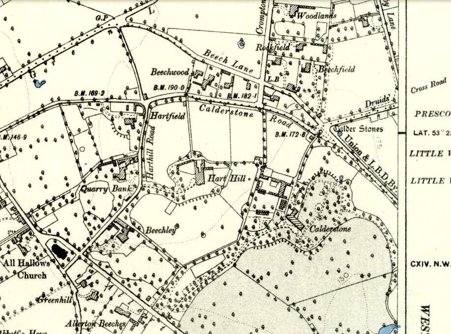
Marked on the 1846 Ordnance Survey map in a position by the road junctions at the meeting of township boundaries, where the aptly-named Calderstones Road and Druids Cross Road meet, several hundred yards north of its present site in Harthill Greenhouses in Calderstones Park, this is a completely fascinating site whose modern history is probably as much of a jigsaw puzzle as its previous 5000 years have been!
Thought to have originally have been a chambered tomb of some sort, akin to the usual fairy hill mound of earth, either surrounded by a ring of stones, or the stones were covered by earth. The earliest known literary reference to the Calderstones dates from 1568, where it is referenced in a boundary dispute, typical of the period when the land-grabbers were in full swing. The dispute was over a section of land between Allerton and Wavertree and in it the stones were called “the dojer, rojer or Caldwaye stones.” At that time it is known that the place was a roughly oval mound. But even then, we find that at least one of the stones had been taken away, in 1550.
Little was written about the place from then until the early 19th century, when descriptions and drawings began emerging. The earliest image was by one Captain William Latham in 1825. On this (top-right) we have the first hint of carvings on some of the stones, particularly the upright one to the right showing some of the known cup-markings that still survive. By the year 1833 however, the ‘mound’ that either surrounded or covered the stones was destroyed. Victorian & Paul Morgan (2004) told us,
“The destruction first began in the late 18th or early 19th century when the mound was largely removed to provide sand for making mortar for a Mr Bragg’s House on Woolton Road. It was at this time that a ‘fine sepulchral urn rudely ornamented outside’ was found inside.”
The Calderstones in 1840
The same authors narrated the account of the mound’s final destruction, as remembered by a local man called John Peers—a gardener to some dood called Edward Cox—who was there when it met its final demise. Mr Cox later wrote a letter explaining what his gardener had told him and sent it to The Daily Post in 1896, which lamented,
“When the stones were dug down to, they seemed rather tumbled about in the mound. They looked as if they had been a little hut or cellar. Below the stones was found a large quantity of burnt bones, white and in small pieces. He thought there must have been a cartload or two. He helped to wheel them out and spread them on the field. He saw no metal of any sort nor any flint implements, nor any pottery, either whole or broken; nor did he hear of any. He was quite sure the bones were in large quantity, but he saw no urn with them. Possibly the quantity was enhanced by mixture with the soil. No one made such of old things of that sort in his time, nor cared to keep them up…”
But thankfully the upright stones remained—and on them were found a most curious plethora of neolithic carvings. After the covering cairn had been moved, the six remaining stones were set into a ring and, thankfully, looked after. These stones were later removed from their original spot and, after a bit of messing about, came to reside eventually in the curious greenhouse in Calderstones Park.
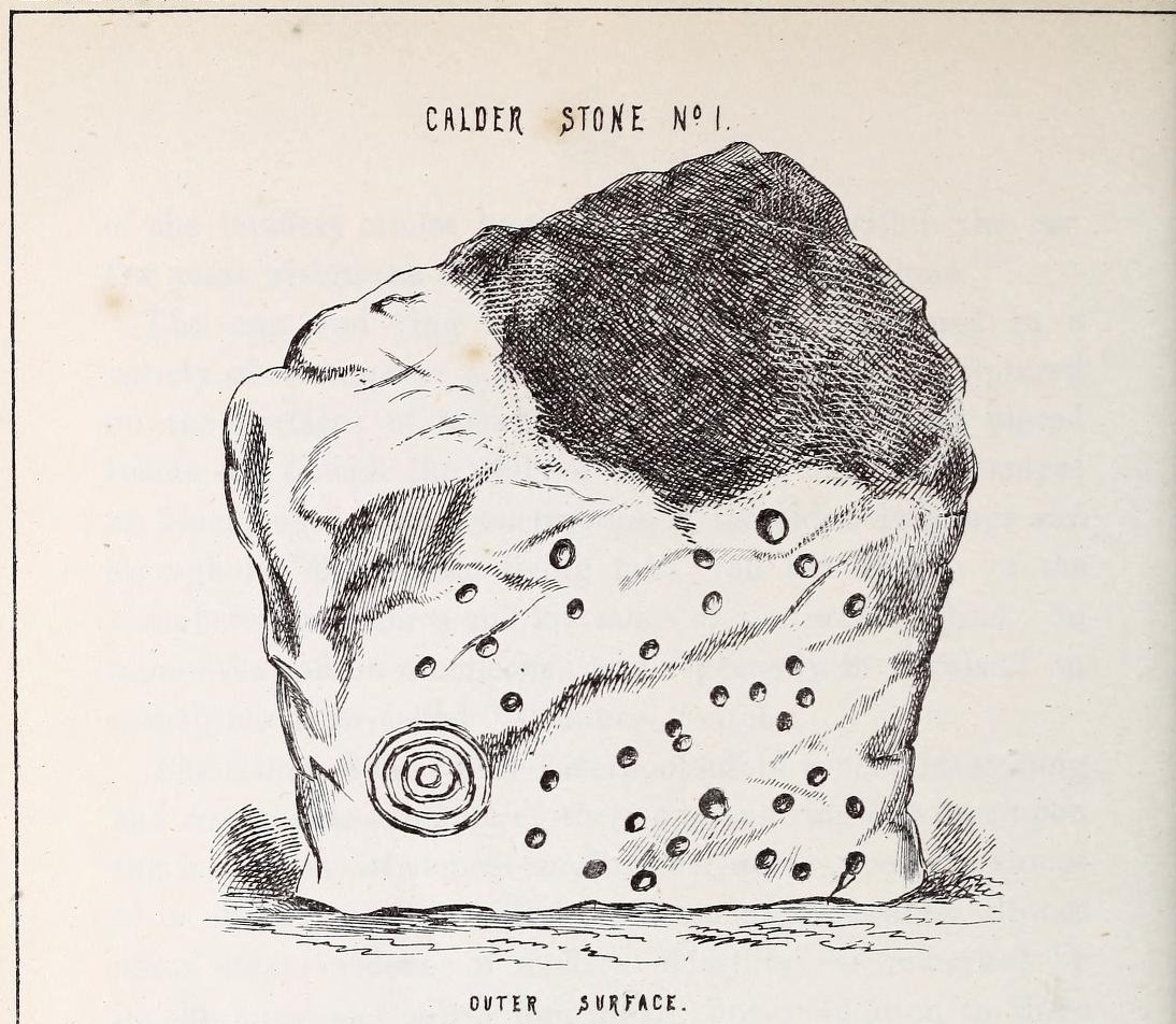
Simpson’s “Stone 1” outer faceSimpson’s “Stone 1” inner face
The carvings on the stones were first described in detail by the pioneering James Simpson. (1865) I hope you’ll forgive me citing his full description of them—on one of which he could find no carvings at the time, but he did state that his assessment may be incomplete as the light conditions weren’t too good. Some things never change! Sir James wrote:
“The Calder circle is about six yards in diameter. It consists of five stones which are still upright, and one that is fallen. The stones consist of slabs and blocks of red sandstone, all different in size and shape.
“The fallen stone is small, and shews nothing on its exposed side; but possibly, if turned over, some markings might be discovered on its other surface.
“Of the five standing stones, the largest of the set (No. I) is a sandstone slab, between five and six feet in height and in breadth. On its outer surface—or the surface turned to the exterior of the circle— there is a flaw above from disintegration and splintering of the stone; but the remaining portion of the surface presents between thirty and forty cup depressions, varying from two to three and a half inches in diameter; and at its lowest and left-hand corner is a concentric circle about a foot in diameter, consisting of four enlarging rings, but apparently without any central depression.
“The opposite surface of this stone, No. 1, or that directed to the interior of the circle, has near its centre a cup cut upon it, with the remains of one surrounding ring. On the right side of this single-ringed cup are the faded remains of a concentric circle of three rings. To the left of it there is another three-ringed circle, with a central depression, but the upper portions of the rings are broken off. Above it is a double-ringed cup, with this peculiarity, that the external ring is a volute leading from the central cup, and between the outer and inner ring is a fragmentary line of apparently another volute, making a double-ringed spiral which is common on some Irish stones, as on those of the great archaic mausoleum at New Grange, but extremely rare in Great Britain. At the very base of this stone, and towards the left, are two small volutes, one with a central depression or cup, the other seemingly without it. One of these small volutes consists of three turns, the other of two.
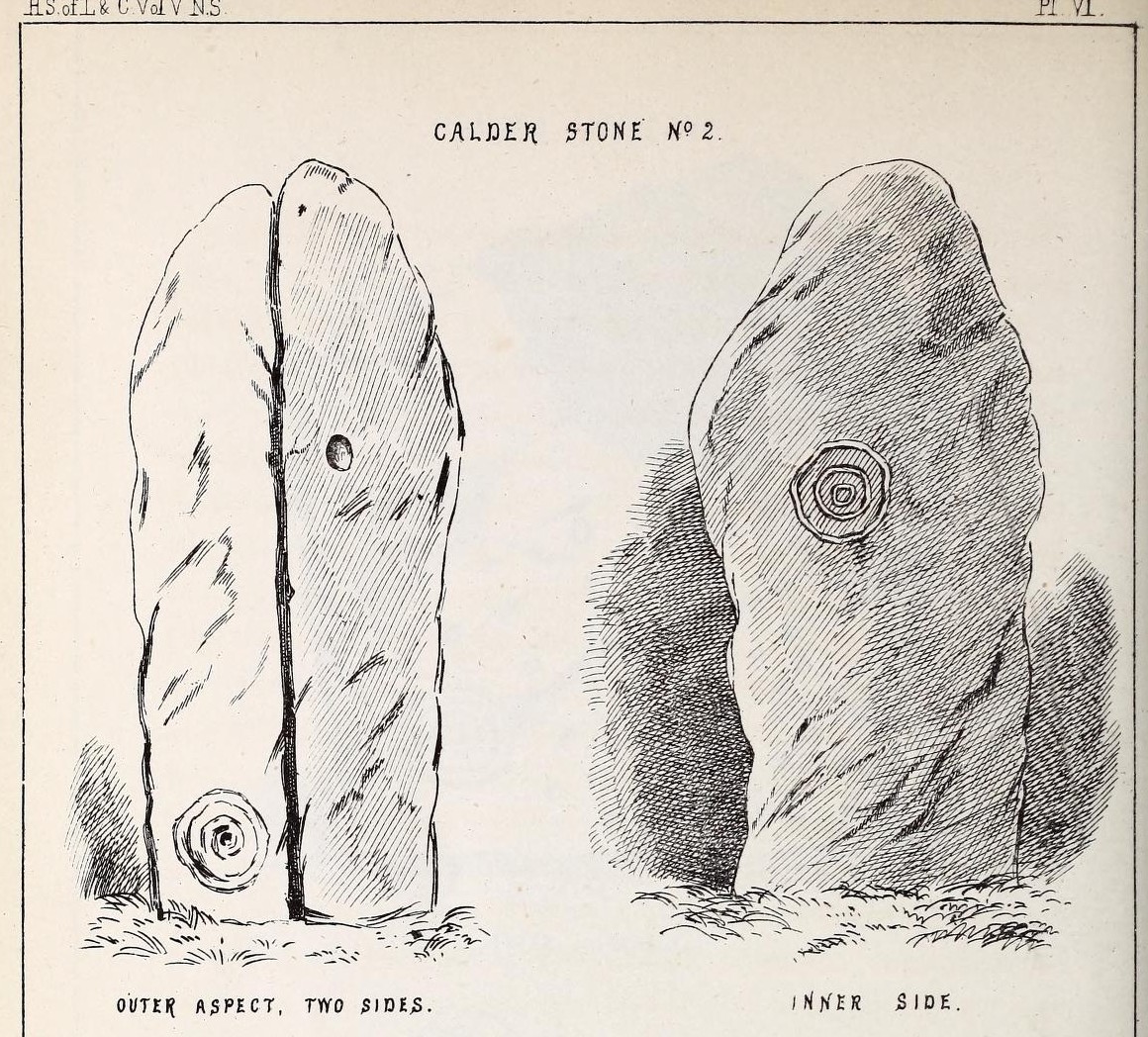
“The next stone, No. 2 in the series, is about six feet high and somewhat quadrangular. On one of its sides, half-way up, is a single cup cutting; on a second side, and near its base, a volute consisting of five rings or turns, and seven inches and a half in breadth ; and on a third side (that pointing to the interior of the circle), a concentric circle of three rings placed half-way or more up the stone.
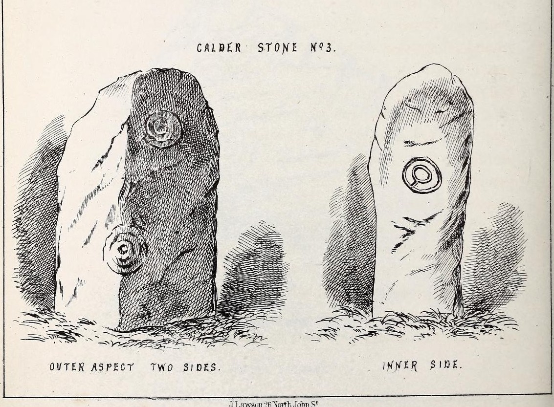
“The stone No. 3, placed next to it in the circle, is between three and four feet in height; thick and somewhat quadrangular, but with the angles much rounded off. On its outermost side is apparently a triple circle cut around a central cup; but more minute examination and fingering of the lines shews that this figure is produced by a spiral line or volute starting from the central cup, and does not consist of separate rings. The diameter of the outermost circle of the volute is nearly ten inches. Below this figure, and on the rounded edge between it and the next surface of the stone to the left, are the imperfect and faded remains of a larger quadruple circle. On one of the two remaining sides of this stone is a double concentric circle with a radial groove or gutter uniting them. This is the only instance of the radial groove which I observed on the Calder Stones, though such radial direct lines or ducts are extremely common elsewhere in the lapidary concentric circles.
“The stone No. 4 is too much weathered and disintegrated on the sides to present any distinct sculpturings. On its flat top are nine or ten cups ; one large and deep (being nearly five inches in diameter). Seven or eight of these cups are irregularly tied or connected together by linear channels or cuttings…
“The fifth stone is too much disfigured by modern apocryphal cuttings and chisellings to deserve archaeological notice.
“The day on which I visited these stones was dark and wet. On a brighter and more favourable occasion perhaps some additional markings may be discovered.”
It wasn’t long, of course, before J. Romilly Allen (1888) visited the Calderstones and examined the carvings; but unusually he gave them only scant attention and added little new information. Apart from reporting that another of the monoliths had carvings on it, amidst a seven-page article the only real thing of relevance was that,
“Five of the Calderstones show traces, more or less distinct, of this kind of carving, the outer surface of the largest stone having about thirty-six cups upon it, and a set of four concentric rings near the bottom at one corner. One of the stones has several cups and grooves on its upper surface.”
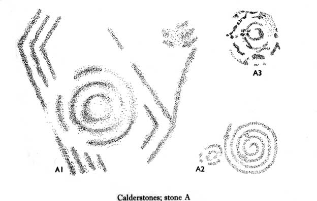
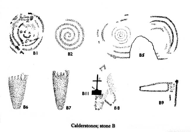
Carvings on Stone A (after Forde-Johnson)Carvings on Stone B (after Forde-Johnson)
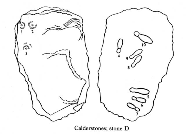
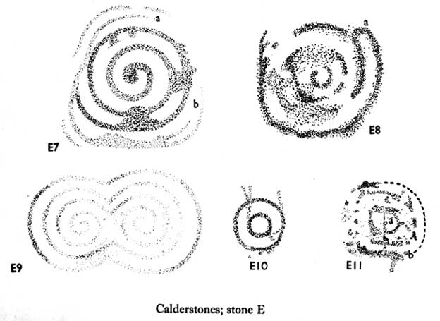
Unusual for him! The major survey of the Calderstone carvings took place in the 1950s when J.L. Forde-Johnson (1956; 1957) examined them in great detail. His findings were little short of incredible and, it has to be said, way ahead of his time (most archaeo’s of his period were simply lazy when it came to researching British petroglyphs). Not only were the early findings of Sir James Simpson confirmed, but some fascinating rare mythic symbols were uncovered that had only previously been located at Dunadd in Argyll, Cochno near Glasgow, and Priddy in Somerset: human feet – some with additional toes! Images of feet were found to be carved on Stones A, B and E. A carved element on Stone C may even represent a human figurine—rare things indeed in the British Isles!
Carvings on Stone DCarvings on Stone E
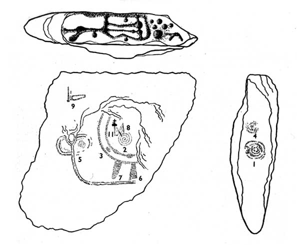
The detailed sketches here are all from Forde-Johnson’s 1957 article, where five of the six stones were found to bear petroglyphs (the sixth stone has, more recently, also been found to also possess faint carvings of a simple cup-mark and five radiating lines).
Elements on Stone C (after Forde-Johnson)More elements on Stone C (after Forde-Johnson)
The date of the site is obviously difficult to assess with accuracy; but I think it is safe to say that the earlier archaeological assumptions of the Calderstones being Bronze Age are probably wrong, and the site is more likely to have been constructed in the neolithic period. It’s similarity in structure and form to other chambered tombs—mentioned by a number of established students from Glyn Daniel (1950) to Frances Lynch—would indicate an earlier period. The fact that no metals of any form have ever been recovered or reported in any of the early accounts add to this neolithic origin probability.
There is still a lot more to be said about this place, but time and sleep are catching me at the mo, so pray forgive my brevity on this profile, until a later date…
Folklore
Curiously, for such an impressive site with a considerable corpus of literary references behind it, folklore accounts are scant. The best that Leslie Grinsell (1976) could find in his survey was from the earlier student C.R. Hand (1912), who simply said that,
“They were looked upon with awe by the people about as having some religious significance quite beyond their comprehension.”
There is however, additional Fortean lore that has been written about these stones and its locale by John Reppion (2011).
Ashbee, Paul, The Bronze Age Round Barrow in Britain, Phoenix House: London 1960.
Baines, Thomas, Lancashire and Cheshire, Past and Present – volume 2, William MacKenzie: London 1870.
Beckensall, Stan, British Prehistoric Rock Art, Tempus: Stroud 1999.
Beckensall, Stan, Circles in Stone: A British Prehistoric Mystery, Tempus: Stroud 2006.
Cowell, Ron, The Calderstones – A Prehistoric Tomb in Liverpool, Merseyside Archaeological Trust 1984.
Crawford, O.G.S., The Eye Goddess, Phoenix House: London 1957.
Daniel, Glyn E., The Prehistoric Chamber Tombs of England and Wales, Cambridge University Press 1950.
Faulkner, B.M., “An Analysis of Three 19th-century Pictures of the Calderstones,” in Merseyside Archaeological Journal, volume 13, 2010.
Forde-Johnson, J.L., “The Calderstones, Liverpool,” in Powell & Daniel, Barclodiad y Gawres: The excavation of a Megalithic Chambered Tomb in Anglesey, Liverpool University Press 1956.
Forde-Johnson, J.L., “Megalithic Art in the North West of Britain: The Calderstones, Liverpool,” in Proceedings of the Prehistoric Society, volume 23, 1957.
Grinsell, Leslie, Folklore of Prehistoric Sites in Britain, David & Charles: Newton Abbot 1976.
Hand, Charles R., The Story of the Calderstones, Hand & Co.: Liverpool 1912.
Herdman, W.A., “A Contribution to the History of the Calderstones, near Liverpool,” in Proceedings & Transactions of the Liverpool Biological Society, volume 11, 1896.
Morgan, Victoria & Paul, Prehistoric Cheshire, Landmark: Ashbourne 2004.
Nash, George & Stanford, Adam, “Recording Images Old and New on the Calderstones in Liverpool,” in Merseyside Archaeological Journal, volume 13, 2010.
Picton, James A., Memorials of Liverpool – 2 volumes, Longmans Gree: London 1875.
Simpson, James, Archaic Sculpturings of Cups, Circles, etc., Upon Stones and Rocks in Scotland, England and other Countries, Edmonston & Douglas: Edinburgh 1867.
Taylor, Isaac, Words and Places, MacMillam: London 1885.
Stewart-Brown, Ronald, A History of the Manor and Township of Allerton, Liverpool 1911.
Acknowledgements: With huge thanks to the staff at Calderstones Park; thanks also to the very helpful staff at Liverpool Central Library.
Holy Well (destroyed): OS Grid Reference – TQ 6538 7081
Also Known as:
St. Thomas’ Well
Shingle Well
Archaeology & History
Sadly the site is gone no longer in existence it was in the roadway along the Roman Watling Street, at its junction with Church Lane, where it joins the relatively recently named Hever Road with Mailings Cross.
Local opinion, erroneously believes that its name derives from there only being one well in the district, but it originates from its substrate, being once called ‘Shinglewell’ describing the substrate. It ended its days as a traditional winch well, with a depth of 150 yards. Watt (1917) described the draw well as having a sign, reading ‘This water is not fit for drinking’— the result of contamination by a nearby stagnant pond. This wooden framework was removed during the First World War, when the well was filled in and domed over. Later, in 1935, a granite slab inscribed with: ‘Site of the Ancient Well, Singlewell Parish or Ifield’ was placed there. Unfortunately, this was removed by the County Council in 1952, and along with the combination of road improvements, the site was largely forgotten.
Folklore
Recorded in a Latin MS and translated by the Rector of Ifield between 1912-1935, the Rev K. M. Ffinch tells of a tradition in great detail, and the following is a brief resume. The legend involves a village girl called Salerna, who is said to have ‘thrown’ herself down the well after being accused of stealing some cheese. Yet, as she fell, she cried out for St. Thomas to save her from her impending doom, and upon finishing her plea, landed on some planks lying at the bottom of the well. They broke her fall, and thus saved her from her dreadful fate. She was then subsequently rescued and because of the ‘miracle’ the well was dedicated to the saint.
The incident is said to have occurred soon after St. Thomas’s martyrdom, and is said to have been one of his first miracles. The name ‘Salerna’ suggests a Roman origin, supported by its location along Watling Street, a Roman Road. Bayley (1978), using a low-land British dialect, which he believed survived until this century, states that ‘Salire Naias’ is ‘the water nymph, who springs forth and runs down’. Consequently, the story of St. Thomas miracle may have been introduced to remove the pagan tradition and refocus the beliefs of the people using a local saint.
References:
Bayley, M.,(1978) Ancient, and Holy and Healing Wells of the Thames Valley, and their Associations.
Ffinch, K.M., (1957) The History of Ifield and Singlewell
Parish, R.B., (1997) “The Curious Water-lore of Kent II: Ghosts, Fertility and Living Traditions”, in Bygone Kent, Volume 18, pp.427–32.
Watt, F., (1917) Canterbury Pilgrims and their Ways
(Extracted from the forthcoming book Holy Wells and Healing Springs of Kent)
ON the A59 Harrogate to Skipton road, right on top where it crosses the barren moors, get to the parking spot right near where the road levels out at the highest point. Walk up the footpath from here onto the moors (south) for about 200 yards till you notice a small black pool ahead of you. From here, walk left (east) offpath and into the heather, roughly along the ridge for about another 150-200 yards. Zigzag about and keep looking. You’re damn close!
Archaeology & History
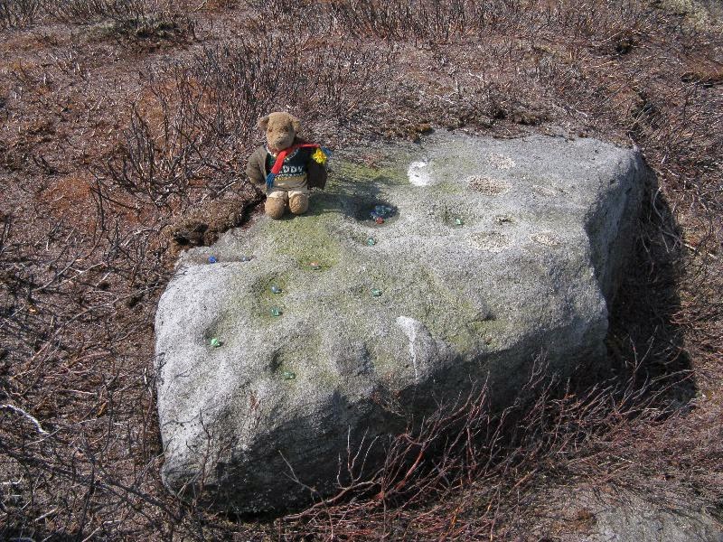
Close-up of some of the cups
Not far from the Gill Head stone and walling, another previously unrecorded cup-marked rock was discovered on the afternoon of Saturday, May 3, 2014, by Danny Tiernan and his famous teddy bear! The stone seems to have been previously well-covered, but was made visible thanks to the annual heather-burning on this part of the moor. He came across it during an exploratory Northern Antiquarian wander to examine a cluster of other neolithic remains hidden on this moor. The carving consists of a series of plain cup-markings, between eight and twelve in number, running along the middle of the rock and outwards nearer to the edges. The cups are between 1-2 inches across and a half-inch deep at the most. The design was first highlighted on Danny’s walking blog, Teddy Tour Teas — and is gonna be difficult to find once the heather’s grown back.
Leave Glentham on the way to Caenby Corner. You pass a footpath marked on the right-hand side (it goes to Highfield farm). The road makes a bend to the right and then before a slighter turn to the left, just before this last bend there is a little lane to the right. Park safely here and then there is copse. You will need to scramble down there and follow the small stream to its source. It runs almost just under the road.
Archaeology & History
Many wells have associations with seasonal customs, but perhaps one of the most unusual traditions is that found in the Glentham Parish in Lincolnshire. Here can be found the Newell or Newell’s Well which had associated with it a rather unique custom: the ceremony of ‘Washing Molly Grime’ The tradition appears to have become confused over the centuries. A full account is recorded by a H. Winn in Notes and Queries (1888-9):
“The church of Glentham was originally dedicated to Our Lady of Sorrows, a circumstance obviously alluded to by a sculpture in stone of the Virgin supporting the dead Christ in her arms, still to be seen over the porch entrance and placed there by some early representative of the Tourneys of Caenby, who had a mortuary chapel on the north side of Glentham church. The washing of the effigy of the dead Christ every Good Friday, and strewing of his bier with spring flowers previous to a mock entombment, was a special observance here. It was allowed to be done by virgins only, as many desired to take part in the ceremony being permitted to do so in mourning garb. The water for washing the image was carried in procession from Neu-well adjacent. A rent was charged of seven shillings a year was left upon some land at Glentham for the support of this custom, and was last paid by W. Thorpe, the owner, to seven old maids for the performance of washing the effigy each Good Friday. The custom being known as Molly Grime’s washing led to an erroneous idea that the rent charge was instituted by a spinster of that name, but ‘Molly Grime’ is clearly a corruption of the ‘Malgraen’ i.e. Holy Image washing, of an ancient local dialect. About 1832 the land was sold without any reservation of the rent charge.”
The origin for the wells name is also confused. Rudkin (1936) notes:
“They reckon it’s called Newell’s well on account of a man named Newell as left money to seven poor widow women..”
However, it is more likely to be simply new well, perhaps deriving its name from ‘eau’, a common word in the county.
When and why the tradition switched from washing the holy image to that supposedly of the Tourney (Lady Anne Tourney a local 14th century land owner) is unclear, but it is possible that the change occurred at the Reformation and that perhaps the money was given to wash both holy image and that of the benefactor and post Reformation only the benefactor washing survived. There is a similar tradition called the ‘Dusters’ in Duffield. The name of the activity clearly survived as Rudkin that:
“ they’d wash a stone coffin-top as in the Church; this ‘ere coffin-top is in the form of a women. ‘Molly Grime’ they calls it.”
The tradition even appears to have earned some note nationwide, for a nursery rhyme about the custom is known:
Seven old maids,
Seven old maids,
once upon a time,
Got when they came
Came of Good Friday,
Seven new shillings
To wash Molly Grime,
In Charity’s name,
The water for washing,
God bless the water
Was fetched from Newell,
God bless the rhyme
And who Molly was I never heard tell.
And God bless the old maids that washed Molly Grime
Sadly the selling of the land appeared to killed off the tradition, except that between 2004 and 2007 a special Father’s Day race for women was established. This involved filling a balloon with water from Newell’s spring and the subsequent attempt for getting it back to the village without bursting it. In essence it remembered the tradition, but sadly it too appears to have fallen into abeyance.
Folklore
Another tradition in the village was that if one drank its waters one was said never to leave the village. A correspondent of Sutton (1997) states:
“An old boy told me about the ‘healing well of Glentham. It was named after a saint but I can’t remember the name he used. Some folk call it Newell’s well. Many people came to take the healing waters and in the spring of the year, the Church held an annual service for ‘good water for the rest of the year’, the service marked a new year of the waters. The well was dressed in a traditional way using clay and flower petals to make some kind of picture, usually a saint. I’m told it look very impressive”
This is presumably before the site was enveloped in scrub as it is now. The report is interesting for a number of reasons; firstly because the correspondent refers to the waters as healing, secondly that it was dedicated to a saint and thirdly the account of well dressing more reminiscent of Derbyshire, and as far as I am aware it is only such example, as well dressing at Welton and Louth appeared to be more garland related. None of these observations have been made elsewhere which either casts doubt in the correspondent or more likely the patchy nature of well traditions in the county.
Despite the loss of the custom, the well still survives, the water clear and flowing arises beneath a stone built chamber of seven courses of stonework with a small square outlet through which the water flows. However, according to recent reports boring in the vicinity has resulted in the water being drained away but I have been unable to ascertain this.
(Essay from the book by R.B. Parish – Holy Wells and healing springs of Lincolnshire)
References:
Parish, R.B., Holy Wells and healing springs of Lincolnshire
Reynolds, Jeff, Glentham Parish Council – Personal Comm.
From Burley train station, take the road uphill onto the moor edge, turning right at the top. Go on for a few hundred yards and park up round the sharp bend. Walk up the steep-ish path on the right-hand side of the rocky valley of Coldstone Beck. Once your on the level with the moors, veer to your right (west) on the footpath parallel with the walling. Barely 50 yards along, watch in the grasses and heather to your left (south). Keep looking and you’ll find it. (apologies for just a 6-figure grid-ref for this stone, but I paid little attention to its position when I was in walkabout mode)
Archaeology & History
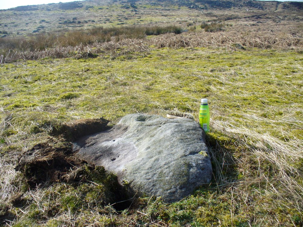
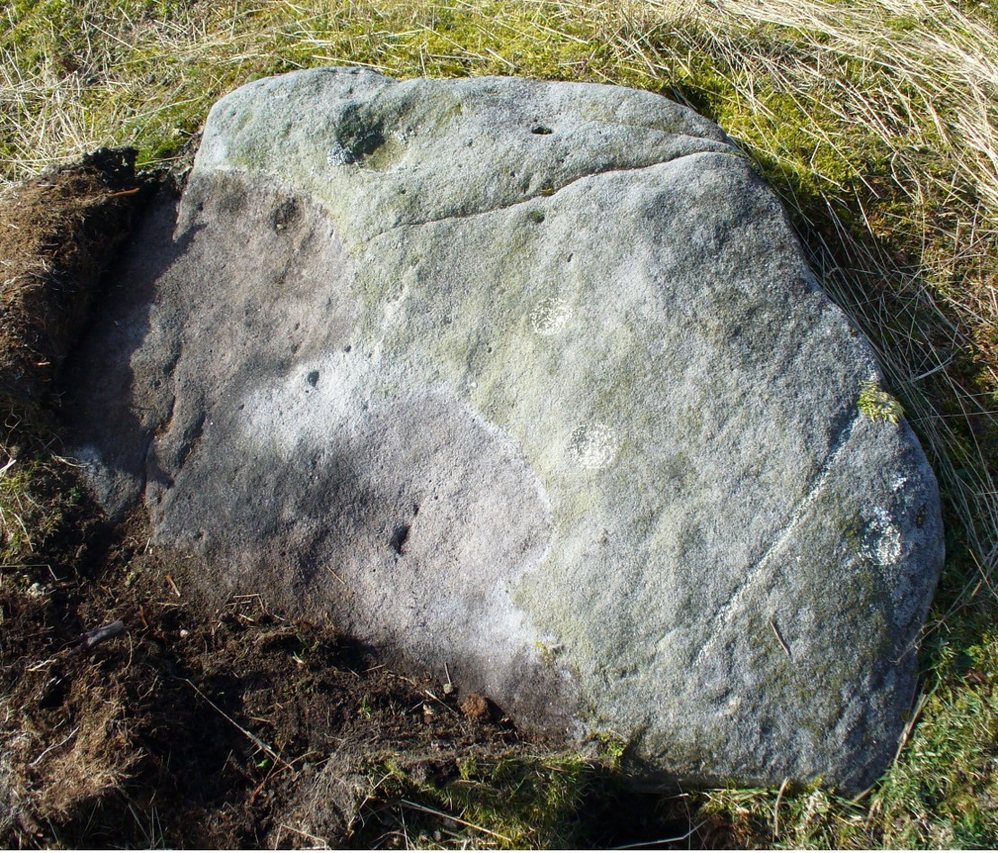
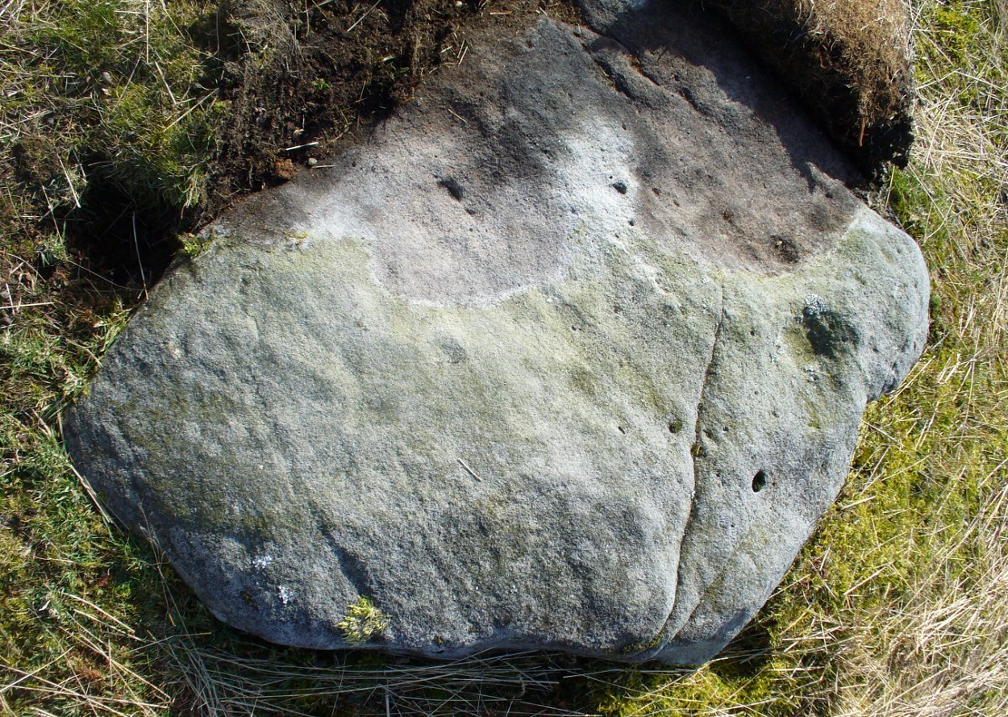
A couple of hundred yards east of the Cold Stone monolith is another petroglyph that has evaded the diligent archaeologists of the region! But it’s easily missed if the daylight conditions aren’t too good. The most notable element on the stone is the large, possibly natural cup-marking on its top-right SW side. It’s that which initially gets your attention and, due to its initial singularity on the rock, you’d turn away and shake your head, muttering that well known petroglyphic mantra of “dunno.” But when the sun and air are clear or low on the horizon, other more faint etchings, almost lost in the worlds of erosion, catches the eye.
Carving faintly highlightedLooking straight down
At least four cups are visible on the stone, perhaps six, mainly near its middle and faintly highlighted in one of the images here. But there is also a pecked carved line here too, running across the shorter northern side of the stone. Near the bottom of this line there is the faint impression of a carved ring, but whether this is a trick of the light or real, I won’t hazard to guess. Not far away is the curiously shaped Chair Stone and its cup-marks. Others are in the vicinity.
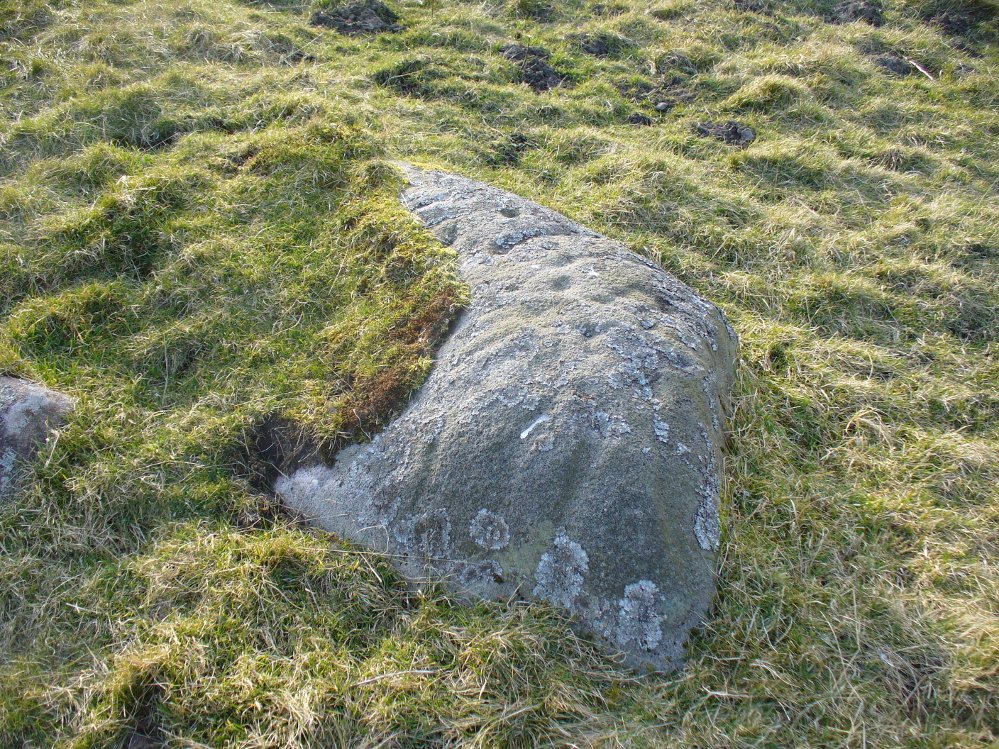
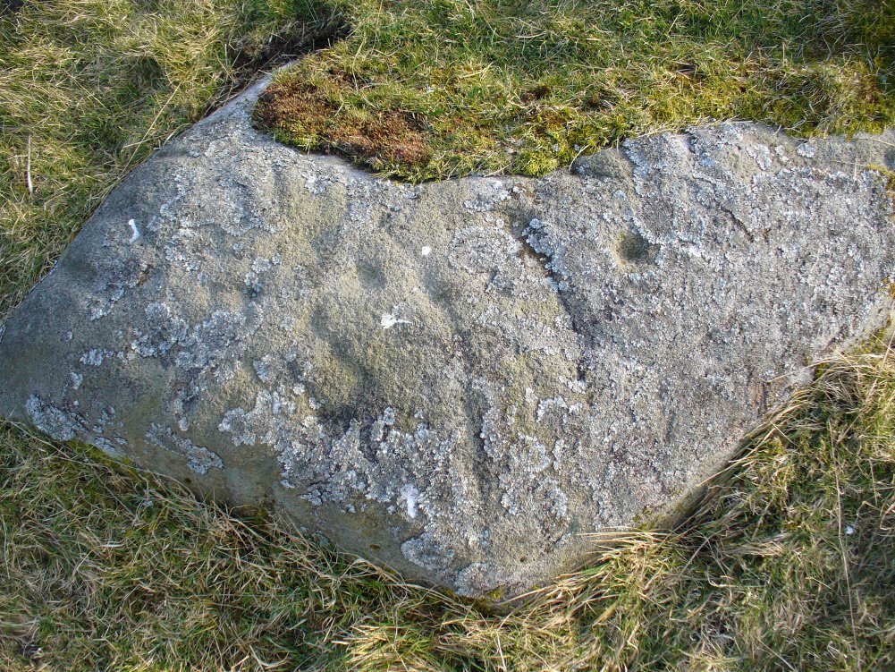
This is another of the many unrecorded cup-and-ring carvings in the region—and one in a small cluster hereby. It was rediscovered several years ago on a Northern Antiquarian outing and, thankfully, remains in good condition. Encrusted by layers of gorgeous lichens, deep into the rock, it has hence proven difficult to explore the entirety of the exact design without tearing off the old lichen covering—which I’ve no intention of doing.
Lichen Stone, from above
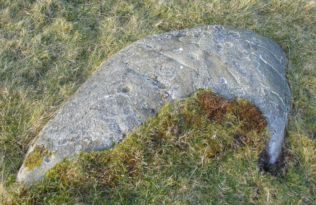
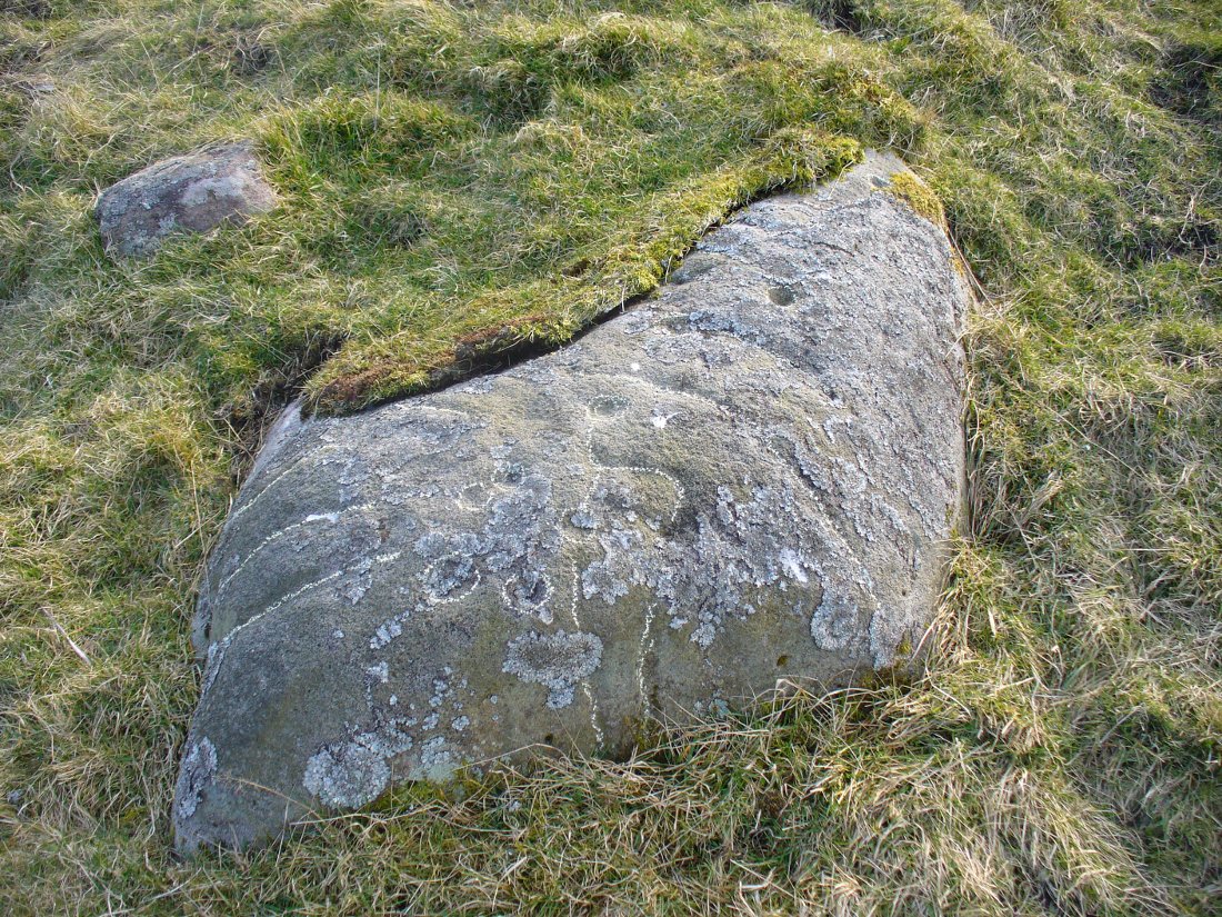
There are at least a dozen cup-markings etched onto the upper surface of this curved stone, with the majority of them clustering around its eastern side. It seems there’s only one cup-marking on the western section of the rock, with the majority of them carved near the middle of the rock and then moving to its eastern section. But the curious features are the interlinking carved lines which you can see have been highlighted on the top and sides of the stone. Initially you get the impression that they’re natural, but it becomes obvious the more you look at them that they’re an integral part of the carving. Some of the lines typically link-up with other cups, whilst a number of them have been carved along and down the vertical faces of the rock, primarily on the east and north-east edges. At least seven of them have been done and they all reach down to ground-level.
Cups & carved linesCarved lines highlighted
It seemed obvious that an even larger design was apparent on the rock, but the stone had been covered in an age of lichen (hence the name) which I didn’t want to disturb; and although no distinct cup-and-ring can be seen here, it looked as if one such motif might have been hiding beneath the lichen cover. But let’s leave the rock and lichen to their own quiet life and move on our way…. to the other carvings nearby, like the impressive Fraggle Rock, or the more basic Snake Stone. Then follow your nose and seek out the other carvings in these fields…
From Burley-in-Wharfedale train station, take the road uphill to the moors, turning right at the top, until you hit the bend where the stream and rocky valley of Coldstone Beck appears. Walk up the right-hand (west) side of the beck until the moorland levels out. Walk along the footpath above Stead Crag for a coupla hundred yards, keeping your eyes peeled for the largest upright stone in the heather about 50 yards into the moors. The other way is to get to Woofa Bank Enclosure and keep walking east through the heather for a coupla hundred yards till you see the tallest upright stone in the heather.
Archaeology & History
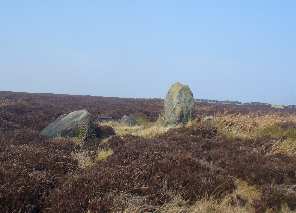
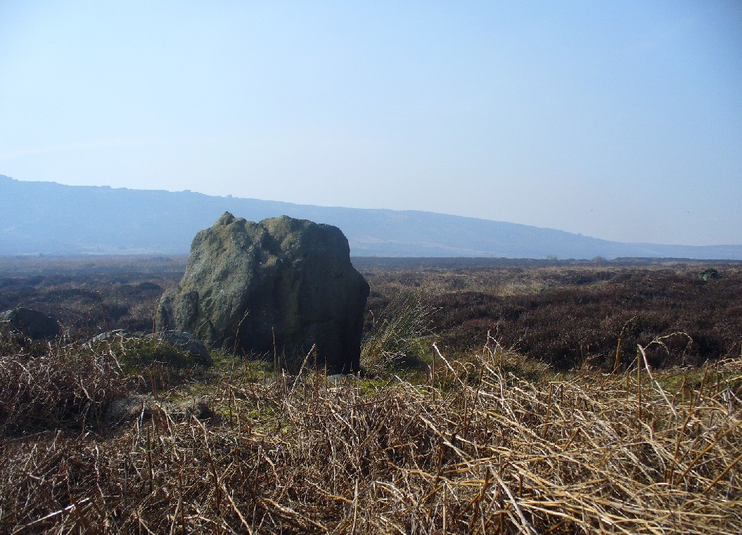
Apart from my own short entry about this site in The Old Stones of Elmet, we have no archaeological account of this standing stone, less than four feet tall and nearly as wide at its maximum, living in a landscape renowned for its excess of neolithic and Bronze Age remains. For those of us who love our megaliths it’s nothing special — but at the same time it’s worth looking at, if only because of the other mass of prehistoric remains close by. It received its name from the adjacent Coldstone Beck a short distance to the east, whose etymology isn’t clear.
Cold Stone, looking eastGazing into a hazy SW
Although we know that many of the sites on this ridge are prehistoric in origin (incredibly some of it still aint registered by those who get paid to do such things), we also need to take into consideration that this site may have been effected by the early industrialists who also made their mark on this section of the moor: they have scarred some cup-and-rings along here, destroyed other remains and left incisions on some rocks which could easily be mistaken as ancient. There is also the possibility that this upright and its adjacent stones were once part of a cairn. If evidence comes to light that the Cold Stone is more recent, we will of course amend this site entry.
Folklore
A number of Cold Stones are found scattered across upland Britain, in the form of crags or solitary stones. In North Yorkshire and beyond, the name is sometimes a corruption of a Call Stone, i.e., a site where village matters were called out prior to the institution of a bell-man. The old Market Cross in Kendal village, also known as the Cold Stone was where village notices were proclaimed.
References:
Bennett, Paul, The Old Stones of Elmet, Capall Bann: Chieveley 2001.
If you park in the first car park at Greenaway Country Park past the lake, and then walk along the road taking the footpath on the left around the lake, continue until one crosses a bridge, just below the Warden’s Tower taking a path which follows a small stream, past a pond and then continue until there is a bridge on the left. Just after this is a path on the right you will reach the Gawton Well.
Archaeology & History
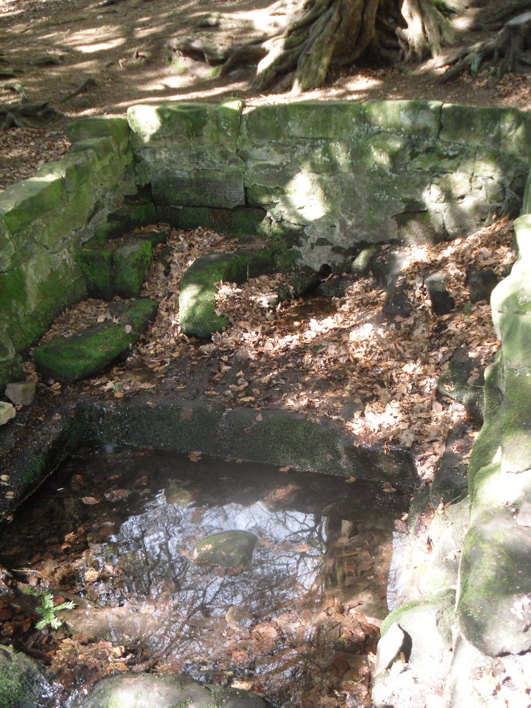
The spring, voted one of the most mystical places and certainly one of the most atmospheric of Staffordshire’s ancient wells, is found on the remains of the Kynpersley Estate. It fills at first an elliptical stone basin, then a small rectangular basin and then a larger one which could have formed a bath. There is a semi-circular stone just after this and it then flows through a number of large rocks forming a stream. The site has an excellent arrangement: the juxtaposition between the man-made and the natural.
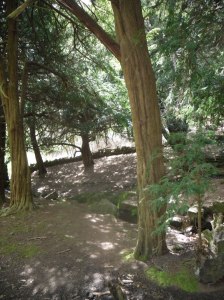
Perhaps what makes this well one of the most evocative and interesting is the fact that it arises in an oval grove of yew trees. Some folklorists and New age Antiquarians have seen this as being evidence of some pagan origin of the well and although it is interesting that the site is unconverted to the Christian faith. However, one must be careful. Firstly the trees do not look that old and secondly the presence of a nearby Warden’s Tower, a folly, suggests that this is perhaps a 18th century piece of antiquarianism. I have been unable to find much more of its history.
Folklore
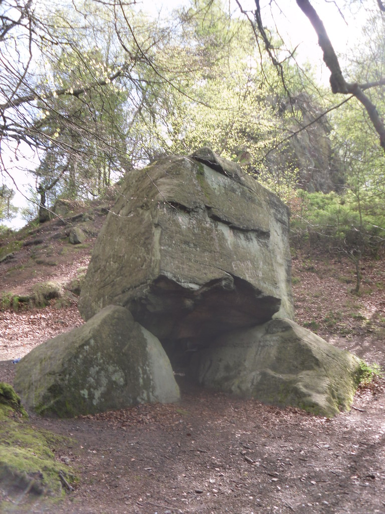
The Gawton Stone
This suggestion of the site being a folly may be justified by the presence of Gawton’s Stone. This is just up from the spring, being a large stone supported by three other stones. Some antiquarians identified erroneously this as either a druidic altar or megalithic structure (it would be impossible to lift the structure). However it is here that legendarily a hermit lived called Gawton who used the well. Often landowners would employ a hermit to add some romance to the estate, although the stone does not particularly look like a comfortable place. Certainly local tradition states that the man came from Knypersley Hall in the seventeenth century, although the house is 18th century and no name is recorded as living there of any note! The house itself dates from the 12th century. Robert Plot (1686) in his work on Staffordshire states that:
“There are many waters such as the water of the well at Gawton Stone…which has some reputation for the cure of the King’s evil..”
The King’s evil was a skin complaint generally called scrofula which was only thought to be cured by the touch of the reigning monarch. Now rarely do I try out springs, but at this time my little boy was suffering with eczema and having tried all sorts of creams I said flippantly try some of the well’s water. I collected it from near the source in a drinking bottle, it felt unusually silky to the skin, and applied some to an area of dry peeling skin on his cheek. Remarkably by the time we had walked from the well to the car the area have healed itself rather miraculously. I only wished I had collected some more to use later, although the area on his face disappeared for good….
In all Gawton’s Well deserves to be more well known, a magical site of which my only clue, many years ago before the internet, to its existence before reaching it was a circle on the OS-map! A site which may reveal its secrets with greater research, which I plan to undertake whilst preparing for the Staffordshire book below.
References:
Parish, R.B., Holy wells and healing springs of Staffordshire (forthcoming) full set of references within.
Plot, Robert, A Natural History of Staffordshire, Oxford 1686.








 Perhaps what makes this well one of the most evocative and interesting is the fact that it arises in an oval grove of yew trees. Some folklorists and New age Antiquarians have seen this as being evidence of some pagan origin of the well and although it is interesting that the site is unconverted to the Christian faith. However, one must be careful. Firstly the trees do not look that old and secondly the presence of a nearby Warden’s Tower, a folly, suggests that this is perhaps a 18th century piece of antiquarianism. I have been unable to find much more of its history.