Many ways to get here, but the easiest for those with cars to is park up on the southeast edge of the hill, at the various scruffy parking bits beside the road at the Nick of Pendle. The view from here is enough to get you going! Walk onto the great hill up to the rounded pap of Apronfull Hill (rather gives it away really!). It’s only a few hundred yards up – about 10 mins up the slope from the road, with awesome views all round once you get there. Tis the small guidance cairn you’re looking at just on the level. You’re there!
Archaeology & History
This would once have been a rather huge cairn/tomb — though when I first found the remains of this place in August 2006, there were no archaeological records describing it that I could find. But there’s very little left of it. The lads who did the quarrying further downhill (where you’ve probably parked your car) are likely to have been the culprits who nicked most of the rocks that once made this huge forgotten tomb. But as you potter about here, it becomes obvious that you’re standing on the much-denuded remains of just such a monument (very similar in size and structure to the more famous Little Skirtful and Great Skirtful of Stones on Burley Moor, or Black Hill round cairn near Skipton). But the remains you can see beneath your feet still give a good idea as to how large it was.
Remnants of the cairn-spoil cover the ground where the monument once stood proud!
You’ll see once you’re stood here that there are hundreds, maybe even several thousands of stones just on and below the ground, scattering a very well-defined roughly circular area measuring at least 21 yards (east-west) by 22 yards (north-south), right by the side of the path. The edges of this ransacked cairn are pretty well defined around the north and eastern sides. Near the centre of the old structure is a very notable ‘dip’ in the ground where it looks as if something has been dug away — though this could just as well be due to the presence of underground water, as indicated by the growth of Juncus grasses. Without an excavation it’s obviously difficult to tell.
Folklore
Twas the following tale which first led my nose to explore this part of Pendle hill. It’s a tale we find at many of our upland tombs, though the record books said there was nowt here! (any myopic archaeologists out there who reckon that folklore has no relevance to their subject, educate one’s self!)
Looking from the Devil’s Apronful towards Jeppe Knave’s Grave
The Devil was having trouble with the folk at Clitheroe Castle (a few miles west) and wanted rid of it. So he picked up various large stones and put them in his apron then threw them towards the castle. Most of them missed, which made him angry and in a rage he accidentally dropped a great pile of rocks on the south side of Pendle Hill, creating the Devil’s Apronful on Apronfull Hill.
In another tale he was said to have stood at the Deer Stones a few hundred yards east of here and threw rocks from there. Perhaps a folk-remnant of where the Apronful stones once came from…? Perhaps not.
Jessica Lofthouse (1976) notes how this old spot was long known by local people as the Devil’s Apronful.
References:
Lofthouse, Jessica, North-Country Folklore, Hale: London 1976.
The Forham All Saints Cursus (image courtesy, Paul Devereux)
Archaeology & History
The remains of this cursus can be found in the valley of the Lark. In Paul Devereux’s (1989) survey of these gigantic neolithic features he described how today we can only see it as crop-markings, stretching in a
“roughly northwest to southeast direction for about a mile; its width approximately 140 feet (42.5 metres). It is comprised of three straight lengths, each at slightly different orientations – there is no way of telling at present (c.1988) whether or not these segments were built at different times, as is believed to be the case at certain other cursuses where changes of direction occur. The northmost terminus has not been located, but the southern one is visible from the air and is next to a circular crop-mark.”
Some 350 yards further on from the end of the cursus is the village church of All Saints, whose old festival date centred around Halloween, or the old pre-christian New Year.
Central section of cursus
Starting at the southern end of the cursus (A), it headed northwest for more than 650 yards (0.6km) before it took its first slight change of direction. Almost all of this first section has been built over by the village; but we can see it in aerial views again on the north side of the village at the edge of the field, at TL 8365 6774 (B). Changing direction slightly, it moves more NNW for another 590 yards (539m) and then kinks again slightly more NNW at TL 8325 6809 (C), before heading onto its final change in direction 464 yards (424m) away at TL 8299 6843 (D). From this point, more recent surveys have shown it to continue further onwards, with another minor alteration in its direction to the north. It goes in a dead straight line for another 336 yards (334.5m), seemingly terminating a short distance before the old Mill Farm at Hengrave, at TL 8291 6876. Just as at the start of the cursus at point ‘A’, where the terminus is curved in a slight arc, so the northern terminus was also curved. The total length of this monument is 1.2 miles (1.9km).
As can be seen in the aerial view (above), a faded double-line of earthworks exists immediately west (left) of the cursus, intersecting and going across the monument. This is the Fornham All Saints causewayed enclosure: another early neolithic monument which may or may not be earlier than the cursus itself.
A curious architectural coincidence (?) can be seen roughly 500 yards west of the central section of the cursus. Running roughly parallel with the prehistoric earthwork is another dead straight avenue leading out, southeast, from Hengrave Hall and, near its terminus, kinks slightly left, just as the cursus monument does about 550 yards away. Fascinating…
References:
Loveday, Roy, Inscribed Across the Landscape, Tempus: Stroud 2006.
Oswald, A., Dyer, C. & Barber, M., The Creation of Monuments, English Heritage: Swindon 2001.
Pennick, N. & Devereux, P., Lines on the Landscape, Robert Hale: London 1989.
Not hard to find really. From Ballachulish, take the western coastal road south, as if you’re going to Oban. After about 5 miles you’ll hit the lovely hamlet of Duror (nowt much here: a hotel, small school and a few cottages). Stop here and walk across the River Duror. A couple of fields down on your left-hand side you’ll see what you’re looking for!
Archaeology & History
Described as “one of the most impressive standing stones in Lorn,” northern Argyll, it “is situated in a level field 180m NW of Acharra. It measures 3.7m in height and 1.1m by 0.6 m at the base, and tapers to a pointed top about 0.4m in thickness; the long axis lies NE and SW.”
Aubrey Burl (Thom, Thom & Burl 1990) thought: “it is possible that this, and other stones near Loch Creran, once marked a prehistoric trackway, 4.5 miles in length.”
Folklore
On the potential folklore side of this monolith, Burl mentions how this monolith – also known as the Hard Stone – “and the site on which it stands, is called Cnoc nam Aingeal, or ‘Angel’s Hillock.'” Does anyone know the story behind this?
References:
Royal Commission on the Ancient & Historical Monuments of Scotland, Argyll: volume 2 – Lorn, HMSO: Edinburgh 1974.
Thom, A., Thom, A.S. & Burl, A., Stone Rows and Standing Stones, BAR: Oxford 1990.
Not quite halfway along the A828 road between Oban and Ballachulish, just before the village of Barcaldine, a large expanse of forested land unfurls on the slopes to your left (east). You can either just walk straight into the woods and follow your nose, or do the easier thing and head up the track into the woods from Mill Farm. As you walk up, keep an eye out for where the open land to your left starts fading. Once here, head straight north into the trees (it’s not too bad and a few animal paths help you along the way). Walk into the trees for a couple of hundred yards and look around. If you hit the triangulation pillar (Cnoc Reamhar), walk back 100 yards.
Archaeology & History
There are actually two monuments here: a small overgrown cairn not far from the forest edge, kerbed with several large boulders between one and three feet high – 15 of which were still in situ in 1974 – with the inner section lower than the surrounding stones. The other more impressive site and much easier to locate is the tall standing stone, nearly 8 feet tall, about 100 yards east of the cairn.
I liked the feel of this place. There’s good clean waters all round, a coupla decent little waterfalls close by, an abundance of healthy wildlife and an old holy well apparently dedicated to St. Columba in the trees a short distance away, though I never got a look at it.
References:
Royal Commission on the Ancient & Historical Monuments, Scotland, Argyll – volume 2, HMSO: Edinburgh 1974.
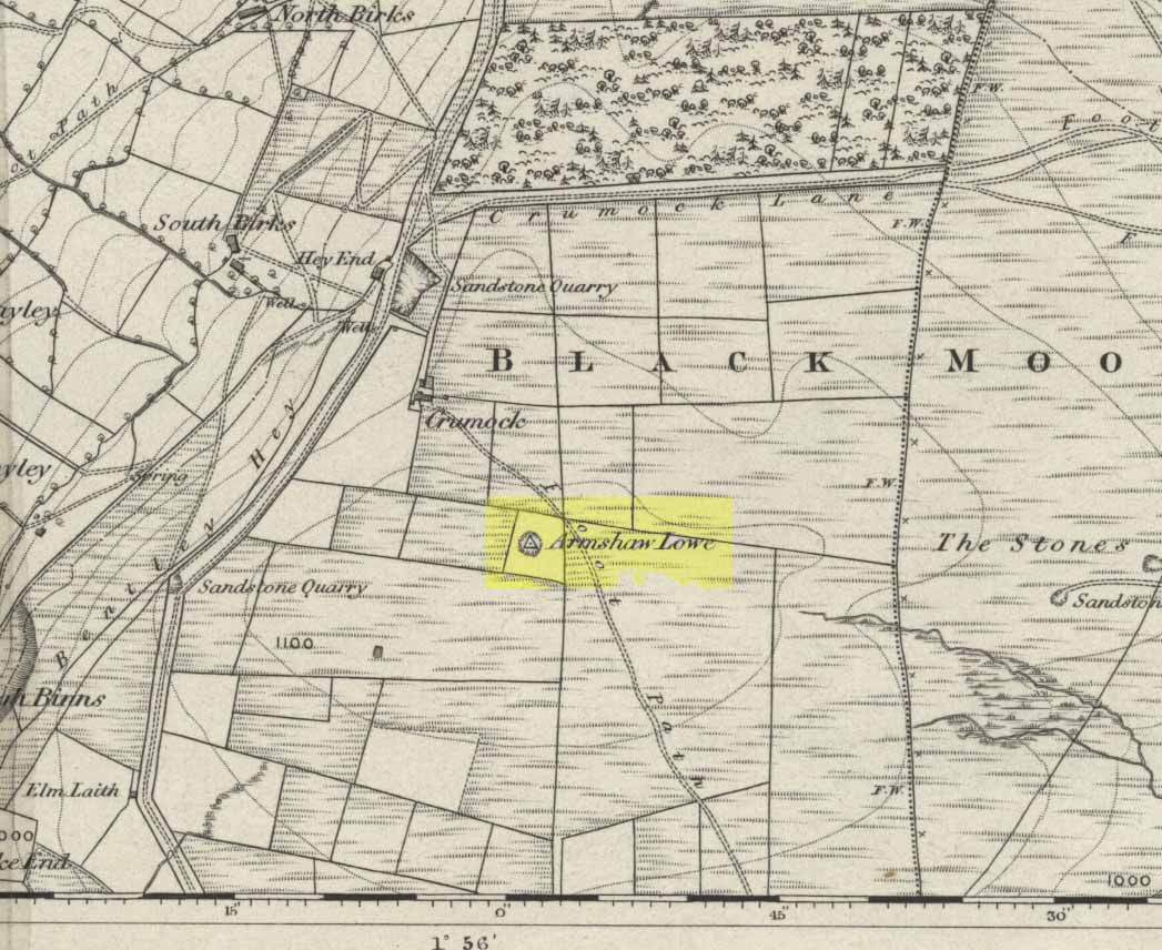
Go along the B6141 from Denholme to Oxenhope, turning right just by the bend which drops into Oxenhope, and head along the small road to Upwood Park camping site. Just before here is the Grange Park Animal sanctuary. Ask there to walk onto the field behind, where you’ll see a rise in the land, as you can see on the rather poor photo I took from the east-side.
Archaeology & History
Although ascribed on early OS-maps as a tumulus (and still shown as an antiquity on the modern ones), this site appears to be simply the end-point along a geological ridge, starting a few hundred yards east of here, consisting of an upsurge of rocks covered in earth and nothing more. A survey of the place done by Bellamy in 1970 (Yorkshire Archaeological Journal, 42:6, 1970) seems to indicate the same. To those who want to test the theory, start by exploring it from Cullingworth Moor and walk along the ridge itself. It seems pretty clear.
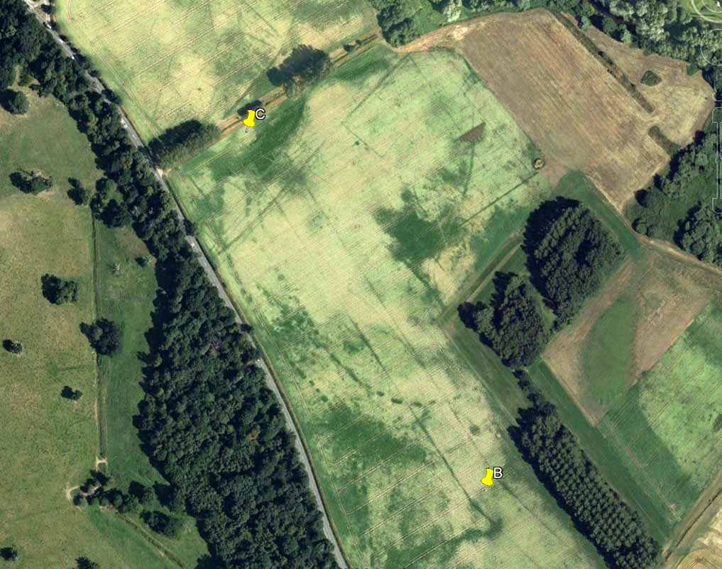
Armshaw Lowe – the small mound in centre of photo
The “antiquarian” element to the site seems to originate in its positioning in the landscape. Armshaw Lowe is on the topmost point of the hills hereabouts, with 360-degree views all round, commanding excellent sights all round. But it’s perhaps the word ‘lowe’ that might be the important bit here, as in old english it can mean an old moot or meeting spot — which it may well have been for local tribes. It is may be this element that gives Armshaw Lowe its lingering antiquarian status.
Check it out for yourselves and see what y’ think. I went up here to see an old burial mound, but found only a decent geological feature atop of local hills. But me ‘n’ the archaeologists might be wrong…
References:
Gomme, G.L., Primitive Folk-Moots; or Open-Air Assemblies in Britain, Sampson Low: London 1880.
Truly takes a bit of finding this one! I s’ppose the easiest way to locate it is by approaching it from the south, from Askwith village, up Hall Lane. Keep walking up the footpath to Top Moorside Farm; then past it, sticking to the same path. A hundred yard or so past here we get onto the moor itself. As you hit the moor, you’ll see that the land rises slowly ahead of you: this is Hollin Tree Hill and you need to walk up here (don’t do this in the summer as it’ll be covered in bracken and you’ll not find a damn thing!). Just before the land starts to levels-out at the top of this small rise, you’ll come across some hut circles. You’re here!
image courtesy of Graeme Chappell
You can also come to this carving via the Askwith Moor parking-bit, then walk along the well-trod footpath, past the triangulation pillar of Shooting House Hill for a coupla hundred yards, then walk straight south into the moor. But to those of you who aint got the nose for it, there’s no footpaths here and some folk might easily lose their way. However, if you reach the rise of Hollin Tree Hill a few hundred yards down the moor, watch out for those same hut circles mentioned elsewhere atop of the rising land. You’re damn close!
Archaeology & History
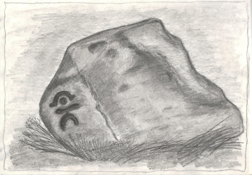
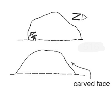
One of my very favourite cup-and-ring carvings this one! It was discovered about 1991 when Graeme Chappell and I were on one of our many archaeology wanderings, seeking out prehistoric remains on the moors north of Ilkley. First described and illustrated in Bob Trubshaw’s (1996) archaeomythics journal, it was later included in The Old Stones of Elmet (2001: 149-152). But when we first found it, this carving – on the vertical face of a small stone, beside an unexcavated hut circle – sent me a bit crazy, as the ‘human’ image in the carving struck me immediately. Needless to say, Graeme was all calm about it while I jumped around like an excited tit! As far as we’re aware, this is the earliest representation of a human figure in the British Isles. There are several other contenders in cup-and-ring design, but this seems the most probable of the lot. Graeme Chappell took a rubbing of the stone several years after we’d found it and the outline clearly shows the image of a human figure. The carving was later catalogued by rock art students Boughey & Vickerman (2003) in their Yorkshire survey as ‘stone 516.’ A female compatriot, the Woman Stone, can be found a few hundred yards east of here, at the bottom of the slope by the near horizon.
The fact that the carving occurs on the southern vertical face of a prehistoric hut circle may have had some significance about the structure itself. Petroglyphs on hut circles are rare—and this one occurs right at the entrance to the structure, the door into the circle. It may represent an image of the person who lived in this hut circle, or perhaps symbolized the nature of the character living there. The carving shows that the person was wearing a head-dress, akin to a horned-man figure – but much much earlier than anything previously recognised in British iconography. The figure may well be a shaman who, perhaps, lived at this circle. The carving was probably painted in lichens and other dyes
The Man Stone carvingBoughey & Vickerman sketch
Be careful not to wander around looking for this when there’s fog on the hills. You’re unlikely to find it! On an excursion up here several years back with Prof. Thomas Dowson and students from the Southampton University Rock Art course, we wandered about all over the place in the dense fog but were unable to find the damn thing! Twas a bittova freaky day, as half the students started crying (they thought I’d got them truly lost in the middle of nowhere as I didn’t have a map, a compass, walking boots, etc – which is how I usually do my wanderings, but they weren’t to know that!) and we must have walked within 10 yards of the carving, but it remained hidden from our prying eyes. But if you like your rock art, check this one out!
Various routes to this giant tomb, which happens to be a way off the roads (thankfully!). Probably the easiest way is from the Menston-side: up Moor Lane, turn left at the end, go 200 yards and take the track onto the moor. Just keep walking. If you hit the rock-outcrop nearly a mile on, you’ve gone past your target. Turn back for about 400 yards and walk (south) into the heather. You’re damn close!
Archaeology & History
Great Skirtful of Stones cairn looking east to Otley Chevin
Due north of the Skirtful Spring water source, this is one of Ilkley Moor’s major prehistoric sites: ‘major’ for a number of reasons – not least of which is the size of the thing! Although getting somewhat overgrown these days as more of the heathlands encroach the mass of rocks that constitute the central ‘tomb’, it is still a formidable heap. Another reason this site is of importance is its position in the landscape: it can be seen as the peak or ‘nipple’ on the landscape from considerable distances north, south and east of here, rising up on the horizon and catching the eye from many miles away. This was obviously quite a deliberate function of the site when it was first constructed – thought to be in the Bronze or Iron Age period (sadly we have no decent excavation here to tell us just when it was made). Another reason for its importance is its position relative to a once huge prehistoric graveyard immediately east. And right next to it we also find a curious circular monument that has never been properly excavated, whose function is unknown. It is also the seeming focal point of at least one, though possibly three prehistoric trackways: one of which goes right past it, though swerves on its southern edge quite deliberately so as to not touch the monument. This trackway appears to have been a ceremonial ‘road of the dead,’ along which our ancestors were carried, resting for some reason at the nearby Roms Law, or Grubstones Circle, a few hundred yards to the west.
Wrongly ascribed as a “round barrow” by archaeologist Tim Darvill (1988), the Great Skirtful cairn was named in boundary changes made in 1733, where one Richard Barret of Hawksworth told that the site was “never heard go by any other name than Skirtfull of Stones.”
In 1901 there was an article in the local ‘Shipley Express‘ newspaper — and repeated in Mr Laurence’s (1991) fine History of Menston and Hawksworth — which gave the following details:
“Mr Turner led the way across Burley Moor to the Great Skirtful of Stones, a huge cairn of small boulders, nearly a hundred tons on a heap, although for centuries loads have been taken away to mend the trackways across the moor… The centre of the cairn is now hollow, as it was explored many years ago, and from the middle human bones were taken and submitted to Canon Greenwell and other archaeologists” – though I have found little in Greenwell’s works that adequately describe the finds here. Near the centre of the giant cairn is a large stone, of more recent centuries, which once stood upright and upon which is etched the words, “This is Rumbles Law.” The Shipley Express article goes on: “Mr Turner explained that ‘law’ was always used in the British sense for a hill, and Rumbles Hill, or cairn, was a conspicuous boundary mark for many centuries. He had found in the Burley Manor Rolls, two centuries back, that on Rogation Day, when the boundaries were beaten by the inhabitants, they met on this hill, and describing their boundaries, they concluded the nominy by joining in the words, “This is Rumbles Law.””
Great Skirtful on 1851 map
Several other giant cairns like this used to be visible on the moors, but over the years poor archaeological management has led to their gradual decline (and in editing this site profile in 2016, have to report that poor archaeological and moorland management is eating into and gradually diminishing this monument to this day). We still have the Great Skirtful’s little brother, the Little Skirtful of Stones, a half-mile north of here. The very depleted remains of the once-huge Nixon’s Station giant cairn can still be seen (just!) at the very top of Ilkley Moor 1½ miles (2.65km) west.* And we have the pairing of the giant round cairn and long cairn a few miles west on Bradley Moor, near Skipton. The tradition of such giant tombs on these hills was obviously an important one to our ancestors.
Folklore
We find a curious entry in the diaries of the Leeds historian Ralph Thoresby, in the year 1702, which seems to describe the Great Skirtful of Stones, adding a rather odd bit of folklore. (if it isn’t the Great Skirtful, we’re at a loss to account for the place described.) Mr Thoresby told how he and Sir Walter Hawksworth went for a walk on Hawksworth’s land and said how,
“he showed us a monumental heap of stones, in memory of three Scotch boys slain there by lightning, in his grandfather’s, Sir Richard Hawksworth’s time, as an old man attested to Sir Walter, who being then twelve years of age helped to lead the stones.”
As far as I’m aware, this old story of the three Scottish boys is described nowhere else.
Like many giant cairns, the Great Skirtful has a familiar creation myth to account for its appearance. In one version we hear that it was made when the local giant, Rombald (who lived on this moor) and his un-named wife were quarrelling and she dropped a few stones she was carrying in her apron. A variation swaps Rombald’s wife with the devil, who also, carelessly, let the mass of stones drop from his own apron to create the ancient cairn we still see today.
According to Jessica Lofthouse’s North Country Folklore (1976), a Norse giant by the name of Rawmr, “fell fighting against the Britons of Elmet and is buried, they say, on Hawksworth Moor” – i.e., the southeastern section of Rombald’s Moor, very probably at the Great Skirtful of Stones. I’ve yet to explore the history and etymology of the name Rawmr…
References:
Bennett, Paul, The Old Stones of Elmet, Capall Bann: Chieveley 2001.
Cowling, Eric T., Rombald’s Way, William Walker: Otley 1946.
Darvill, Timothy, Ancient Britain, AA: Basingstoke 1988.
Laurence, Alastair, A History of Menston and Hawksworth, Smith Settle: Otley 1991.
* Whoever is/was supposed to be responsible for the care of the Nixon’s Station giant cairn monument should be taken to task as it’s been virtually obliterated since when I first came here 30 years ago. Which useless local archaeologist and/or council official is responsible for its destruction? Who allowed it to happen? Why are Ilkley Moor’s prehistoric monument’s being so badly looked after by those who are paid to ensure their maintenance? Are their heads up their arses, in the sand, or—don’t tell me—the prawn sandwiches are to blame!?
On this curious, broken, basin-shaped rock — thought by some to have at one time played a part in an old cross whose remains are in the Abbey Museum — are two deep cup-shaped hollows, in which were once “three noble globes of white marble” that were used for oracular purposes and were said to have originated in druidical rites. In Miss McNeill’s (1954) survey of the island, she tells that:
“near the edge of the path leading to St. Oran’s Chapel, there lies a broad, flat stone, with a slit and a cavity on its surface. Here there used to lie some small round stones which pilgrims were wont to turn sunwise within the cavity; for it was commonly believed that the ‘brath’, or end of the world, would not arrive until this stone should be worn through.”
The small stones that were once in the Brath were ordered by the Church to be thrown into the sea; but local folk replaced them with three other small stones, maintaining the traditional rites of this stone until they eventually stopped sometime in the 19th century. But in Major-General James Forlong’s (1906) study, he tells of a somewhat earlier mythic origin to this old stone, saying:
“In Iona the Druids are said to have made the flat altar stone called Clachan-nan-Druidhean, or Druid’s Stone, the stone of fate or of the last day, with round stones fitted into cup hollows on the surface, which the pious pilgrim turns round. The world will end when the stone is worn through. The Culdee monks preserved this monument.”
And what little is left is still preserved to this day. The curious “end of the world” motif was something that was grafted onto an earlier mythos: what Mircea Eliade called the “myth of the eternal return”, wherein Nature’s annual cycle —from birth, life to death and subsequent renewal, endlessly, through the seasons—was the original status, later transmuted by the incoming judaeo-christian cult of linear time and milleniumism relating to a literal “end of the world” when their profane myth of Jesus returning to Earth occurs. We might also add that the stones which once rested into the hollows of the Clach Brath would likely have possessed divinatory and healing qualities, as comparatiove studies suggest.
References:
Eliade, Mircea, The Myth of the Eternal Return,
Forlong, J.G.S., Faiths of Man – volume 1, Bernard Quarithc: London 1906.
Holder, Geoff, The Guide to Mysterious Iona and Staffa, Tempus: Stroud 2001.
McNeill, F. Marion, Iona: A History of the Island, Blackie & Son: Glasgow 1954 (4th edition).
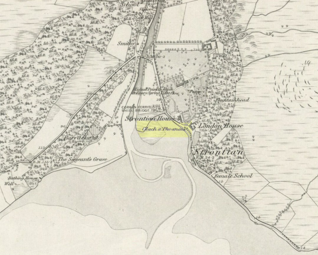
As you enter the village from the east, onto the A861 road, the Strontian Hotel is on the right-hand side of the road and you can’t fail to notice. Stop!
Archaeology & History
Clach a’ Phaonais on 1872 map
Shown on the first edition OS-map of the region in 1875, this old worn standing stone, more than six-feet tall, can be seen at the edge of the drive. There’s an iron ring is attached to it, which I thought might have made it an old Bull Stone in bygone days, but no such lore is remembered. Also known as the Branks Stone, it’s Gaelic name probably means the ‘stone of penance,’ and folk were chained to it in eaelier days for bad behaviour. It was widespread across the Highlands to tie criminals to stones and wooden poles, naked, for 24 hours and let the midges get to them. Crime was down to a minimum up here!
Folklore
As the locals at Strontian Hotel told me (thanks Finlay), “several stories have emerged locally. It marks a clan chief’s grave, a sighting stone for the equinox but the most plausible one is based on the fact that there is an iron ring on the side of the stone facing the loch and it was used to tie up barges taking lead from the local lead mine. It supplied the raw material for shot during the Napoleonic and Crimean wars.”
Aknowledgements: Big thanks to Anne and the Megalithic Portal for additional help on this one.
This giant site—deemed as Iron Age by some and medieval by others—is on the verge of complete destruction as the adjacent quarrying company cuts closer and further into the sides and top of the monument. Local people and archaeologists need to do something about this, or it will be lost forever as the Industrialists once again destroy more of our ancient heritage in order that they can feed their god of Money.
Folklore
Legend has always told that great treasure existed beneath the grounds of this Brigantian hillfort, found on the moor-edges to the east of Manchester. Long ago, one man came along to see if he could find the treasure, said to consist of a huge chest of gold. The man brought two horses and the ground within the fort was gradually cleared away until, to the man’s surprise, the legendary chest was revealed!
Attaching chains to it and the horses, the man shouted:
“Gee, whoa, whoo! Bonny, Buck and Bell,
I’ll have this chest o’ gowd, i’ spite o’ all t’ devils in hell!”
But barely had the words left his mouth and the chest began to move, when the devil himself appeared in the shape of a huge hen that breathed fire! This scared the horses so much that they bolted and snapped the chains, taking their master with them but leaving the treasure-chest still in the ground. To this day the chest still remains, hidden in the Earth.
References:
Winterbottom, Vera, The Devil in Lancashire, Cloister: Stockport 1962.