An unexcavated ring cairn in a very good state of preservation can be seen in the field immediately west of the River Halladale. Measuring more than 14 yards across east-west and 15 yards north-south, the site stands in association with several other unexcavated cairns.
Folklore
Although some of the cairns here have been found with prehistoric burials in them, tradition tells that the cairns here were the result of “a great battle between the native Pictish inhabitants and the invading Norsemen.” So wrote George Sutherland, many moons ago. He continued:
“The Norsemen were defeated in that battle, and Halladha, their leader, was slain. It is from him that the river and the dale take their name. The battle was fought on a hillside, on the east side of the river and that hillside is covered with cairns which are supposed to mark the graves of those slain in this battle, but the body of Halladha, the norse leader, was interred on the west side of the river, and his sword was laid in the grave beside his body. Near the circular trench where he is said to have been buried there are several heaps of stones which are supposed to mark the graves of other Norsemen of note who fell in the battle.”
References:
Sutherland, G., Folklore Gleanings and Character Sketches from the Far North, John o’ Groats Journal: Wick 1937.
Once located on the south side of the stream between the ‘lost’ village of Eastburn and the cottages at Battleburn, this burial mound was one of many explored by the great J.R. Mortimer (1905), who told that:
“On June 24th, 1884, it measured about 40 feet in diameter and 4½ in elevation, and had a depression in the centre, which might have been caused by a former opening. By the old inhabitants of the neighbourhood it is known — like several other similar mounds near settlements — by the name of Mill Hill. A 15-feet square was cut from the centre and the natural ground beneath was found to consist of 3 feet of clay, resting upon chalk gravel. Through this clay and into the chalk gravel beneath was a roughly-cut trench, 3½ feet deep by about 3 feet wide, running north and south the whole width of our excavation and beyond, and from about the centre of the mound a similarly roughly-formed trench was observed to run east and west…”
In the sections that Mortimer and his fellows excavated, they uncovered various intriguing deposits, including the remains of ox, goats and horses. Later deposits were also located in and around the mound, showing it had been used in more recent centuries.
Folklore
Mortimer suggested this site was once an old moot site; comparing it to a place of the same name a short distance west at Kirkburn.
References:
Mortimer, J.R., Forty Years Researches in British and Saxon Burial Mounds of East Yorkshire, A. Brown & Sons: London 1905.
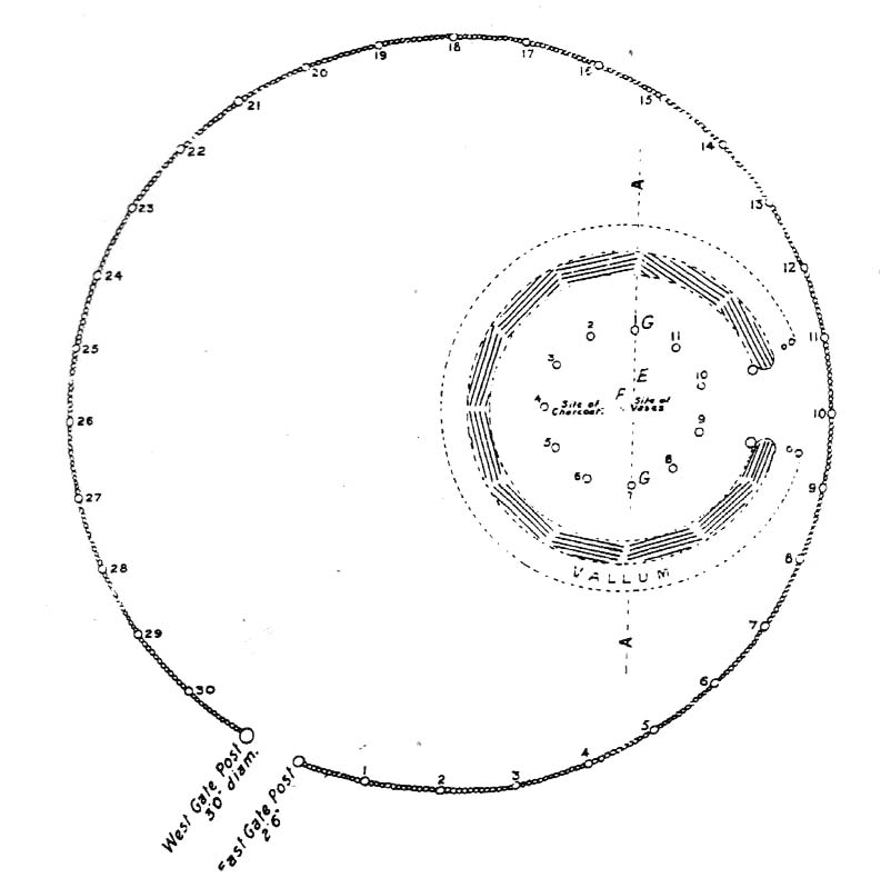
Bleasdale Ring & enclosure plan (Syd Wilson, 1900)
Pretty easy to find, and a nice walk to boot! Head up to Bleasdale Church (worth a look in itself!), keep going up the path north to the aptly named Vicarage Farm. From here you’ll notice a small copse of trees on your left (east) heading to the hills. To those of you who like Predator, “it’s up there – in them trees…!”
Archaeology & History
On my first visit here in the company of John Dixon and other TNA regulars, my first impression was “this is a henge” – and noted subsequently that it’s been described as such by several writers. But the general category given to this fascinating place is a ‘timber circle.’
Bleasdale ‘henge’ circle
First discovered at the end of the 19th century and described in considerable detail by Mr Dawkins (1900), this is a gorgeous-looking monument was erected in at once a gentle and tranquil, aswell as an imposing natural setting, at the foot of Fair Snape Fell (to the northwest) and Bleasdale Fell (due southwest). These aspects of the landscape would have had obvious mythic importance to the people who built this ring amongst the trees. A condensed version of Dawkin’s material was described in J. Holden’s (1980) Story of Preston, that outlined this circle as being,
“a centre for religious worship in about 1700 BC. It was made up of a circle of timber posts which enclosed an area 45 metres in diameter. In the centre was a small mound surrounded by a ring of oak posts and a circular ditch. Inside the mound there was a grave that had in it two pottery urns filled with human bones and ashes. Examination of the contents of these urns shows that the bodies were wrapped in linen and burnt on a funeral pyre. A small ‘accessory’ cup was found inside one of the urns and this may have contained food or drink for the afterlife.”
Urns from Bleasdale Ring1898 photo of Shadrach Jackson (left) & Tom Kelsall (centre) digging the site
Located within a much larger circular enclosure, the internal Bleasdale ‘henge’ Ring consisted of a small circle of eleven timber posts near the edge of the ditch, and an entrance way to the east, to or from which was an avenue of further wooded posts that led to the edge of the larger enclosure. It gives the impression that this was some sort of avenue along which a ceremonial procession may have took place, strongly suggesting a ritual function. Robert Middleton (1996) told that,
“The post circle and barrow appear to respect each other (in date), whilst the enclosure may be later. The post circle has been dated to around 2200 BC, although the context and reliability of this date is unclear.”
Looking out eastwards from the middle of the internal henge-style ring and through the ‘entrance’ we find an alignment with a large notch on the skyline which, modern folklore ascribes, is where the midwinter sun rises — which is very believable, but I aint seen it proven anywhere yet.
A much greater and full excavation report of this site was written by Raymond Varley (2010), whose essay I urge fellow antiquarians to read.
References:
Dawkins, W.B., ‘On the Exploration of Prehistoric Sepulchral Remains of the Bronze Age at Bleasdale,’ in Transactions of the Lancashire & Cheshire Antiquarian Society, volume 18, 1900.
Dixon, John, Journeys through Brigantia – volume 8: Forest of Bowland, Aussteiger Publications: Barnoldswick 1992.
Edwards, Ben, “The History of Archaeology in Lancashire”, in Newman, 1996.
Gibson, Alex, Stonehenge and Timber Circles, Tempus: Stroud 1998.
Holden, Jennifer (ed.), The Story of Preston, Harris Museum: Preston n.d. (c.1980)
Middleton, Robert, “The Neolithic and Bronze Age,” in Newman, 1996.
Newman, Richard (ed.), The Archaeology of Lancashire, Lancaster University 1996.
Sever, Linda (ed.), Lancashire’s Sacred Landscape, History Press: Stroud 2010.
We were graciously guided to this spot by local archaeological authority, Pete Glastonbury — which is good, cos otherwise it’d have probably taken us all day to find the damn thing! Best way to get here is out of the Avebury circle, east, up for about a mile up the Herepath or Green Street till you hit the ancient track of the Ridgeway. Turn left and walk up the gentle slope for another 350 yards or so, then note the footpath on your right. Go down the slope for about 150 yards, keeping your eyes peeled for the smooth rock with the slits in it, not far from the Holed Stone!
Archaeology & History
Although classified on the Wiltshire Sites & Monuments Record as an “unclassified feature,” this is one of a number of whetstones (as we call ’em up North) that feature in various settings in and around the Avebury region: literally, a rock used for sharpening axes, daggers and other metallic artifacts. First rediscovered in the spring of 1963 by a Mr Inigo Jones when he was out exploring the many rocks hereby for rare lichens and any more cup-markings like the one at nearby Fyfield Down, the site we see today is merely a long piece of stone with five or six long lines or grooves cut into the top-end, along which the ancient weapons and tools slid and cut into the rock, sharpening them.
It was thought until recently that this was the prime function of this stone; but following excavation work done here by Pete Fowler and his team in 1963, it seems that the stone actually stood upright! Digs were made on three sides of the stone and some earlier disturbance seemed apparent:
“The material appeared to be redeposited on top of an earlier ground surface, inferentially of medieval or earlier date. At the north end of the sarsen bench, the lip of a pit or trench was partly excavated. It showed clearly in plan as a feature dug into the top of an undated surface level with the disturbed top of the clay-with-flints; it was filled with flinty, clayey humus similar to that through which it was cut. In the top of that fill was a heavily weathered sarsen, c 0.6m by 0.45m, and a cluster of smaller, broken sarsen stones. The hole was at least 0.45m deep, its bottom as excavated marked by an increase in the density of flints. The evidence, though incomplete, suggested very strongly that the feature was part of a hole dug to take the pollisoir as an upright stone.” (my italics, Ed)
In the same dig, a medieval coin of King John (1199-1216) and the remains of a medieval horseshoe were found beneath the stone, giving Fowler and his team the notion that the stone had been split and pushed over at this period. Consistent evidence of activity from the neolithic period onwards was expected and found here.
In Lacaille’s (1963) original description of the site, he gave a most accurate description of the dimensions of the stone and its incisions. Highlighting its proximity to a cluster of other stones, as well as being close to a wide ditch, Lacaille’s measurements were thus:
“From 1ft (0.31m) above ground at its south end the regular surface of the sarsen slopes to the grass, its main axis being aligned about 15° west of the true north and south line. In length the stone measures 5ft 6in (1.68m) above the grass, and 2ft 10in (0.86m) in width.
“Closely grouped in the south-eastern corner of the sarsen there are six hollows. In plan the largest and southernmost is of long elliptical shape, 1ft 8in (0.5m) long and 9in (0.23m) at widest and 1in (0.0254m) deep. From its wider end near the eastern long margin there protrudes a short groove. Beside this, and curving slightly inward, there is another groove, 1¼in (0.028m) wide and ½in (0.013m) deep. It is as long as the large basin-like cavity. Next to it there runs one of similar length and width, but of only half the depth. In turn, a third groove, ½in (0.013m) wide, 1ft 8in (0.5m) long, has been worn at right angles to the long edge but to a much deeper hollow than its companions. At 2in (o.051m) to the north a lesser version of the main basin occurs. Like this it measures 1ft 8in (0.5m) in length, but is only 2¼in (0.058m) wide and ¾in (0.016m) deep. Vague in places over its interior length of 10in (0.25m), but attaining a maximum width of 1¼in (0.028m), a last hollowing shows faintly at both ends and nowhere deeper than 1/8in (0.0032m).”
The Polisher & its marksCeloria & Lacaille’s 1963 drawing of the stone
It appears that this fallen standing stone was being used to sharpen knives and axes whilst it stood upright and, in all probability, as a result of this ability would have been possessed of magickal properties to our ancestors. Metalwork was an important province of shamanism and smiths, whose practices were deeply enmeshed in the very creation of mythical cosmologies. Hence, the simple act nowadays of sharpening metal tools onto rocks would not have been a mere profanity to the people who came and used this stone to re-empower their weapons, but would have been entwined within a magickal cosmology. The spirit inherent in this stone would likely have been named and recognised. Today it is forgotten…
It also seems that this standing stone was part of some ancient walling. Aerial views clearly show it along the line of some sort of enclosure that runs down the slope, along the bottom and back up and around. In the same stretch of this enclosure walling we find the Holed Stone a little further down the slope. And holed stones, as any student of folklore and occult history will tell you, have long-established magickal properties of their own…
References:
Fowler, Peter, Landscape Plotted and Pierced: Landscape History and Local Archaeology in Fyfield and Overton, Wiltshire, Society of Antiquaries: London 2000.
Grigson, Geoffrey, The Shell Country Alphabet, Michael Joseph: London 1966.
From the Avebury stone circle, walk out eastwards and straight up the ancient Ridgeway for about a mile until it levels out and meets up with the adjoining track upon the hilltop. Instead of going left or right, go straight across and onto the footpath that crosses Overton Down, until you reach the wide horse-racing track lookalike called ‘the Gallops.’ Stop – don’t go on it – and follow the fence down for a coupla hundred yards till you’ll see the fenced-off rise with a modern ‘barrow’ enclosed within. You’re very close! From here, go another 100 yards or so down and keep your eyes on the rise of land with rocks scattered around it. That’s it!
Archaeology & History
From all accounts, there’s been nowt of any consequence written about this site — which is bloody incredible to be honest!! We came here on a fine day (that’s Mikki, Geoff and June) in the company of the local Avebury magus, Pete Glastonbury. Crossing Overton Down towards an experimental “barrow” that some archaeo’s have knocked-up, the rise in the land here stands out quite clearly, saying (at the very least), “look at me!” But until Pete Fowler (2000) first described this “unrecorded kerbed round barrow” a few years back, it had escaped the noses of all previous archaeological surveys! How!?
What the hell do archaeologists in the Avebury area do with themselves if they can’t pick this sorta monument out!? But anyway…
Overton Down cairn – looking NW
This is quite a large rounded cairn structure by the look of it. At least 30-feet across, probably kerbed from the initial look (only for a few minutes, sadly). Local writer Terence Meaden has apparently found the site of some importance in his studies (not yet published). Its position here in the landscape was what caught my attention more than anything: it stands on the crest of the hill and has superb uninterrupted views far across the Avebury landscape. This siting was obviously quite deliberate. Less than 100 yards due north of here are two curiously placed stones which may ‘frame’ the cairn for a southern lunar alignment. I had no time to look at this really, so it would be good if some local Avebury dood could check this out. The outlying stones may be merely fortuitous, but it’d be good to know for sure!
The site has been plotted amidst a mass of landscape changes dating from the neolithic to medieval periods. It seems probable, on first impression, that the ‘cairn’ is of Bronze Age in character (though could be earlier), but until detailed analysis has been made we obviously won’t know for sure. A short distance to the south we have the much-denuded Overton Down site X1: another Bronze Age burial that yielded three beaker graves when Fowler excavated the place in the 1960s.
For those of you into geomancy, meditation and the subjective realms of genius loci, this one really grabbed me. Give it a go and lemme know what you get. But please, no stupid pagan or New Age offerings — the site doesn’t need that sorta thing.
References:
Fowler, Peter, Landscape Plotted and Pierced: Landscape History and Local Archaeology in Fyfield and Overton, Wiltshire, Society of Antiquaries: London 2000.
This rather delapidated spring of water (there are actually two springs here) marks the western edge of the parish boundary, just on the south-side of the A368 road towards Ubley, on what Phil Quinn (1999) described as “a neglected triangle of shrubby ground.” Its name derives from once being associated with a prehistoric tomb, or barrow, as the associated field-names of Barrows Orchard and Barrow Cross here indicates. Sadly however, all remains of whatever tomb there once was appears to have gone. Aerial imagery shows what may have been two or three barrows in the said field.
Folklore
A haunted site: the folklore here is akin to banshee-lore and similar mythic figures. The fact that it marked the old boundary line between here and Ubley may have something to do with it. Quinn (1999) says how,
“Local folklore states that the well was haunted by the ghost of a woman washing cabbages”!
But this vegetative lore is likely a mistranslation of a local dialect word. Precisely what the spirit was supposedly ‘washing’ seems to have been lost in translation.
References:
Quinn, Phil, The Holy Wells of Bath and Bristol Region, Logaston: Almeley 1999.
Tumulus (destroyed): OS Grid Reference – TQ 163 703
Archaeology & History
This is one of very few prehistoric tombs that are known about from the London region and — surprise, surprise! — very little is left of the place. No surprise really. It appears to have first been explored soon after Queen Victoria came to the throne
“A barrow on the south side of Sandy Lane was excavated in 1854. It revealed some much disturbed burials, some flint tools and part of a bronze dagger.” (Ching & Howe 1980)
There were in fact the remains of three people found here: one at base level; the other just below the top; and the third body comprised remains that appear to have been buried just beneath the surface. The tomb was a big thing aswell — being nearly 100 feet across and more than 10 feet high. Pity there’s little to be seen of it today…
References:
Ching, Paddy & Howe, Ken, Teddington – As it Was, Hendon: Nelson 1980.
Gordon, E.O., Prehistoric London– Its Mounds and Circles, Covenant: London 1946.
Merriman, Nicholas, Prehistoric London, London Museum 1990.
Spence, Lewis, Legendary London, Hale: London 1937.
Despite a footpath being marked on the OS map, there’s none I could find and the only way to get there is to make your way through the heather. Park at the Wyming Brook nature reserve car park on Redmires road, take the signposted path besides the notice board and follow the line of the dry stone wall. Go through the gate and continue till you come to the end of the wall where a path leads off to your left through the broken wall, follow the path through the boggy bit and head uphill till you get to the highest point of the path by another wall with a path the other side. From here it gets a little tricky! You’ll now need to go off path heading NNE and down hill till you come to the post-and-wire fencing where you should pick up a slight path heading WNW (your left) and head for the high point about half a mile in front of you. Just before you come to the high point you’ll have to cross the stream (easily done). The cist lays on the flat ground just beyond the brow of the rise.
Archaeology & History
A long cist around 3 feet wide and 6 feet long in a well preserved condition aligned almost — but not quite — East/West on a prominent position on Hallam Moor, commanding views over Ash Cabin flat, Rivelin Valley and the A57 road. The only restricted view is to the northwest, where the moor rises then drops down again towards the Headstone.
There are 3 side-stones still in situ: the largest around 1 metre tall, the others still in place being about 70cm. The stones that would have made up the rest of the walls lay close by.
When you’re at the site it’s obvious why it’s in this location: the views are spectacular and afford excellent views of the surrounding area. A burial site with a vista truly fit for a king!
Archaeologically there’s not much info kicking around that I can find and I’m indebted to Stubob for alerting me to it’s presence. It’s very unlikely you’d be walking this area for any reason other than to visit the site, as there are decent paths across the moor to the most popular site in this area, the Headstone off to the North West. Remains of the Ash Cabin Flat stone circle are about 750 yards southeast of here.
A real gem of a site and a “must see” if your in the area.
Follow the directions to reach the Devil’s Den, a half-mile north of Clatford up the footpath towards the Fyfield Down cup-marked rock. You can’t miss it! The cup-markings are on the top of the capstone.
Archaeology & History
First described and illustrated by local historian and photographer, Pete Glastonbury, as far as I’m aware these cup-markings have not previously been included in any of Wiltshire’s archaeological surveys (that can’t be, surely?). The only reference I’ve found — not untypically — is from one of the early editions of the english Folklore Journal.
…and again!Devil’s Den cup-markings
At least two well-defined cups stand out on the top of the capstone. Each of them have ‘cracks’ running out of them, with the easternmost one of them (closer to the edge) turning into a channel which runs upwards on the stone, before then leading down off the edge of the rock. Each cup-mark is very clear, about two inches across and about a half-inch deep.
Archaeologists can check these cups out and work out for themselves whether they’re natural or not. They’re far more qualified than I on such matters and may be able ascertain other faint remarks on the stone. The proximity of the nearby Fyfield Down cup-marked rock, several hundred yards to the north, shows that such petroglyphs can be found in this region. Although we cannot expect many examples of rock art in this area (the rock’s damn tough and takes some burrowing into), it is likely that more carvings await discovery.
Folklore
The capstone on which these cup-markings are seen was told to be immovable and had lore said of it akin to that found at the great Whispering Knights, near the Rollright Stones. But the main piece of lore describes the cups quite specifically. In an article by Alice Gomme (1909), she told that:
“if anyone pours water into any of the natural cup-shaped cavities on the top stone at midnight, it will always be found in the morning to be gone, drunk by a thirst-tormented fiend.”
The tale is later repeated in Kathleen Wiltshire’s (1975) survey, where she too mentions the cup-marking (though only one), saying that,
“if a person pours water into the natural cup-shaped cavity on the top stone at midnight it will always be found to be gone in the morning — drunk by the devil.”
This folklore motif — repeated in Grinsell’s (1976) text — is found at rock-art sites in a number of the northern counties, where milk has been poured into the cup-markings (some of which were known as ‘cat stones’) and left overnight for the spirits to drink. In the case we have recorded at Devil’s Den, the spirit of the place seems to have been demonized, as is common.
Miss Gomme (1909) also reported the curious ingredient that the spirit of a white rabbit with glowing eyes would appear on the capstone at midnight and help the devil demolish the site with the aid of eight oxen! On this latter matter, I am duly informed by one-in-the-know that, to “those of us that know the locals and their humour, we just know this tale was made up for a visiting townie!”
References:
Gomme, Alice B., ‘Folklore Scraps from Several Localities’, in Folklore Journal, 20:1, 1909.
Grinsell, Leslie V., Folklore of Prehistoric Sites in Britain, David & Charles: London 1976.
There are several tumuli near the top of the hill here, but only one of them really stands out. Nick Thomas (1976) told it to be one “of the best preserved bowl barrows in Surrey.” A brief description of the relevant tombs, running north to south:
“the first is 75ft across and 6ft high; the second, which has a surrounding ditch 9ft wide, is also 75ft across, but is 8ft high. The third has a diameter of 42ft and a height of 4ft. The last is 54ft wide and 5½ft high. It has a surrounding ditch 8ft wide. ” (Thomas 1976)
None of the tombs had been excavated up to the early 1980s, but I’m not sure if anything has been found since then. There was also a potential “great stone” up here that was mentioned by John Aubrey in the late 17th century, but nothing has been seen of it since. In all probability this was a standing stone or the remains of some prehistoric tomb.
Folklore
Several hundred years ago the King’s antiquary, John Aubrey, told the curious tale of the great cauldron that was said to have been found here:
“In the vestry (of Frensham church, in Surrey), on the north side of the chancel, is an extraordinary great kettle or caldron, which the inhabitants say, by tradition, was brought hither by the fairies, time out of mind, from Borough-Hill, about a mile hence. To this place, if anyone went to borrow a yoke of oxen, money, etc., he might have it for a year or longer, so he kept his word to return it. There is a cave where some have fancied to hear music. On this Borough hill…is a great stone lying along, of the length of about six feet. They went to this stone and knocked at it, and declared what they could borrow, and when they would repay, and a voice would answer when they should come, and that they should find what they desired to borrow at that stone. This caldron, with the trivet, was borrowed here after the manner aforesaid, and not return’d according to promise; and though the caldron was afterwards carried to the stone, it could not be received, and ever since that time no borrowing there.”
In relation to the folklore that is generally attached to the tumulus on top of the hill here from which modern lore ascribes the cauldron to have originated, when A.G. Wade (1928) came to investigate the nature of the site and the folktale he found that,
“there are several folk-tales other than those given by Aubrey. One relates that it was dug up on Kettlebury Hill, south of Hankley Common, by the monks of Waverley Abbey, and that it was taken by them to Frensham for brewing ale. Another tale says that it was a loan from the fairies of Thursley — there are tumuli in this parish, south of Ockley Common — and that Mother Ludlam, a medieval witch who lived, according to tradition, in Ludlam’s Cave in Moor Park, was the owner and lender. The cave was dug by a monk of Waverley Abbey who, when the water supply of the Abbey failed, found that three springs joined here, and by enlarging their outlets and bringing them together he obtained a good supply of fresh drinking water…”
Mr Wade was also unable to satisfactorily show that the Borough Hill named in Aubrey’s survey and Frensham Common hilltop were one and the same.
References:
Aubrey, John, The Natural History and Antiquities of Surrey, E. Curll: London 1719.
Thomas, Nicholas, Guide to Prehistoric England, Batsford: London 1976.
Wade, A.G., “The Great Cauldron of Frensham,” in Antiquity, 2:6, June 1928.


")


