Enclosure (destroyed): OS Grid Reference – ST 6706 6307
Also Known as:
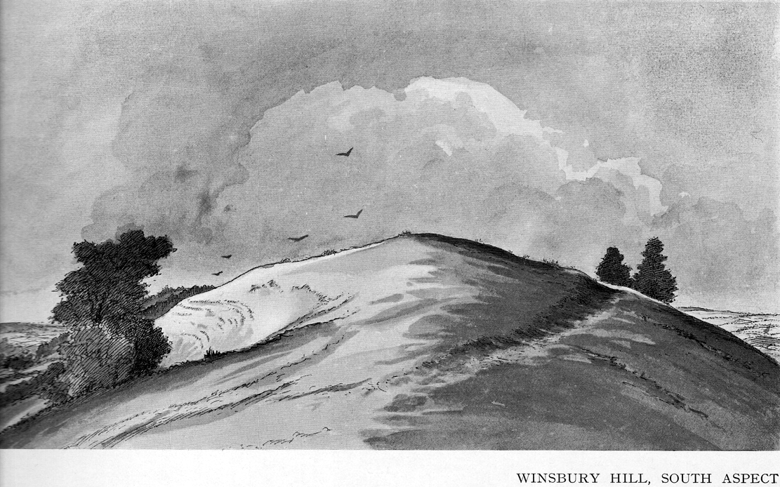
Windsbury Hill
Archaeology & History
Winsbury Hill earthworks
Apparently, all traces of the possible prehistoric camp or enclosure that were located by Edward Burrow in the 1920s, seems to have vanished. Very little remained of it even then. Lower down the slopes are a distinct series of ancient lynchets (or cultivation terraces), which may date back to the Iron Age—these are clearly visible on the eastern and western sides. Mr Burrow’s (1924) account of the site was as follows:
“Just south of Stantonbury Camp, near Bath, on the adjoining height known as Winsbury Hill, I have traced the almost obliterated remains of a ditch running round the shoulder of the hill, which I have indicated on my drawing. (above)
“On the south and eastern slopes of this prominent hill there are various terraces and scarps, which would repay further investigation. Possibly Winsbury was fortified as an outlier of the more pronounced Stantonbury Camp, standing directly on the line of the Wansdyke, which runs across the valley towards English Combe.”
References:
Burrow, Edward J., Ancient Earthworks and Camps of Somerset, E.J. burrow: Cheltenham 1924.
Although cited in all modern archaeology texts as a series of four henge monuments, a recent article by J. Lewis & D. Mullin (2011) inform us that these “are not henges but belong to a tradition of enclosure that predates them and had a different function.” We’ll have to wait and see what they mean by that! In the meantime, we’ll have a quick scurry through the historical accounts of these four impressive ‘henges’ as Burl, Piggott and the others call ’em.
Surrounded at all angles by numerous barrows and tumuli, these four great henge monuments were shown on the 1887 Ordnance Survey map as a row of ‘Supposed Ring Forts’, when such ideas were in vogue, running in a line roughly SSW-NNE; the third one up having a couple of ponds within it. A brief early account of them was given by Harry Scarth (1859)—who was describing the series of nine round barrows a few hundred yards to the south—who told them to be “circular banks” each 500 feet across. The first more detailed account was in A.H. Allcroft’s (1908) classic text, where he wrote the following:
“…Close to the Castle of Comfort Inn, where the high road to Bristol crosses the line of the old Roman road running north-westward towards Charterhouse, there lies immediately west of the high road a series of four circles…all of one size, all of one plan, and all as mathematically exact as circles could well be when executed in such a soil and on such a scale. Although they have suffered greatly from the mining operations which have scarred all the Mendips, as well as from the plough — one of the four is almost obliterated — they are still quite easy to make out. The diameter of each is some 550 feet within the area, which is surrounded by a broad low vallum, and that again by a correspondingly broad and shallow ditch. The height of the vallum above the ditch, where best observable, is some 5 feet. There are no determinable entrances. The most southerly of the group is about 250 feet away from the second ; the second about 200 feet away from the third; and a line joining the centres of the first and third passes through the centre of the second also, and points 17° east of north. The fourth circle lies 1,200 feet away from the third, not in a right line with the others, but slightly to the west. Between the third and fourth circles passes the Roman road. Within the third circle is an old pond of some size.
“With every appearance of being all of one date, and that a venerable one, these circles lack every characteristic of military works. Their peculiar disposition, their painstaking regularity, and their identity of size, all suggest that they must, if really old, be of ritual, and perhaps of astronomical character”
Old drawing of the central hengesHenge 1, recently damaged (courtesy Pete Glastonbury)
Allcroft’s ideas of ritual and astronomy were pretty good for the period, as we take it for granted these days that such events occurred at henges — so the existence of four such sites right next to each other, would have made this one helluva place in neolithic and Bronze Age periods. A few years after Allcroft, the henges were described in Mr Burrow’s (1924) excellent illustrated survey, from which the drawing of the two central henges is taken (the two ‘R’s in the background highlight the line of the Roman road which runs past them). Burrow’s didn’t add much more of any note, simply telling:
“…in the fields north and south, are placed earth-work rings, each about 180 yards in diameter, on a line placed slightly north by east. The most northerly of these rings is almost obliterated, but the three on the west of the road from Chew Stoke to Oakhill are quite clearly defined, as my drawing (above) will show. I have been able to include two of these remarkable rings in my picture, the edge of the bank (which was, when I saw it, fringed with yellow gorse), being about 6 feet above the level of the ditch outside. It is generally supposed that these ringed earthworks were connected with some prehistoric ritual, and Hadrian Allcroft thinks were used for primitive astronomical observations or the construction of a primitive calendar.”
Tratman’s plan of Priddy HengesAnother view of Henge 1 (courtesy Pete Glastonbury)
Many years later when archaeologist K.S. Painter (1964) came to describe these henges, he listed them as “stone circles” (what the hell was he on!?), but this error may derive from the finding of several stones that once existed inside the southernmost Henge 1. These were uncovered following excavation work done here by E.K. Tratman (1967) and his colleagues, who explored and numbered the four henges—running from south to north—as follows:
“Circle 1: This is tolerably complete. A portion of the southwest quadrant has been destroyed by mining and there are three modern gaps in the ring. Mining has involved the ditch on the west and south, and to a small extent on the east. There is an irregular extensive hollow west of the centre and this too is a product of mining and contains a number of large stones so derived. The circle is not quite a true one, being flattened slightly on the west. The circle has a diameter from bank top to bank top of 520ft. The single original entrance is NNE of the centre. Stones 1 and 3-7 were removed by the farmer before excavation, but subsequent ploughing immediately after removal did not reveal any change in soil texture or colour. Stone 8 was placed in its present position quite recently. It is not known where it came from. Other stones have recently been placed on top of the bank east of the entrance by the farmer (1964-5). Stone 2 is in a relatively ancient position.
Circle 2: This is a true circle and its diameter and position of its entrance are similar to Circle 1. It has been considerably disturbed by mining. A group of stones (10-14) and stone 9 represent modern collections from the field. None of them is in its original position. There are two modern gaps in the ring.
Circle 3: This is distinctly flattened on the east and west. The N-S diameter is 520ft and the E-W 490ft from bank top to bank top. The northeast quadrant reported by Allcroft as being levelled is still traceable. The circle has been greatly disturbed by mining… The entrance is SSW of the centre, the opposite pole to circle 1 & 2, and has probably been widened, perhaps by miners. The marsh may be an original feature or the product of mining. The two ponds are certainly modern, and so is a small mound, which is probably spoil from the major pond.
Circle 4: This is incomplete. It has a diameter of 560ft, which is considerably larger than any of the others. The OS map shows only the eastern semi-circle remaining. However, the bank and in part the ditch can be traced…If the visible and proved end of the ditch on the SSW was intended to be at the edge of the causeway, then the entrance would have been in the same position as that of Circle 3.”
Very recently, a local land-owner quite deliberately bulldozed a large portion of the southern henge in this complex, destroying much of it. This act of criminal vandalism will hopefully not go unpunished and is, at the present time, going through the courts.
…to be continued…
References:
Allcroft, A. Hadrian, Earthwork of England, MacMillan: London 1908.
Burrow, Edward J., Ancient Earthworks and Camps of Somerset, E.J. Burrow: Cheltenham 1924.
Lewis, J. & Mullin, D., “New Excavations at Priddy Circle 1, Mendip Hills, Somerset,” in Proceedings of the University of Bristol Speleological Society, volume 25, 2011.
Painter, K.S., The Severn Basin, Cory, Adams & Mackay: London 1964.
Scarth, Harry M., “Some Account of the Investigation of Barrows on the Line of the Roman Road Between Old Sarum and the Port at the Mouth of the River Axe,” in The Archaeological Journal, volume 16, 1859.
Dead easy this! (though a bittova cheat) Get to the Bristol City Museum and look inside. This Google map should help those of you who don’t know Bristol too well.
Archaeology & History
Grinsell’s drawing of the carved slab (PPS 1957)
Found amidst a large cluster of other neolithic and Bronze Age remains—with the amazing line of the Priddy henges just a few hundred yards to the southeast—this is one helluva rare relic this thing: a carved stone, with seeming cup-marks and engraved “feet” no less, which was found when dug out of a prehistoric tomb way down South. Obviously a buncha northern lads and lasses must’ve been on one helluva piss-up! (y’ never know…) Although the tomb — a round barrow by all accounts — was well-known and excavated in 1930, the carving was somehow not noticed by the archaeologists when they dug here! But it has to be said, at that period many archaeologists thought rock art to be insignificant and unworthy of study, so perhaps their ignorance stemmed from the academic myopia of the time.
But at least they gave a reasonable description of the tomb itself. It was due to be destroyed and the considerable mass of material from it was used for widening the nearby road!!! Thankfully, for some reason, “the chamber or cist was left in situ” under the ground. Leslie V. Grinsell (1957) takes up the tale:
“The barrow appeared to be about 100 feet in diameter and 3¾ feet high, but it had been spread and its height reduced by many ploughings. Excavation showed that the barrow, which was of the bowl type, was composed of fine mould throughout, and had never been enclosed by a ditch. In the centre of the barrow, there was a stone chamber or cist, the external dimensions of which were 5½ feet long, 4½ feet wide, and 2½ feet high. The floor, which was ‘crazy-paved’, was approximately on the ground-level. The cist was placed with its long axis SE-NW. The late Father Ethelbert Horne, who wrote the excavation report, stated that the south-eastern slab, which was inserted 6 inches deep into the floor, had the character of a ‘closing-slab’, and outside it were several packing stones. There was a large cover slab of Dolomitic Conglomerate. The small northwestern slab is of Carboniferous Limestone, and the south-eastern slab is of Liassic Chert, but the large south-western and north-eastern slabs are of sandstone derived from the vicinity. The essential characteristics of this structure are therefore that is was abnormally large for a stone cist, had a strong suspicion of a ‘closing slab’ (implying some kind of entrance?) at the south-eastern end, and was above ground level, with its floor on that level.
“On the floor of this chamber or cist, at the foot of the approximate centre of the south-western slab, was a heap of burnt human bones, free from any admixture of charcoal. As these bones had been broken small after being cremated, their determination was by no means easy. Prof E. Fawcett…expressed the belief that they may have comprised the remains of an adult and a young person.”
But it was in 1956 that the carvings were noticed on the cist remains — by Mr Grinsell and his friend, C.S. Taylor. At first they thought that some of the etchings were of human hands, but they later realised they were of human feet. Grinsell wrote:
“The Foot carvings: The feet shown are all single feet, no two forming a left-and-right pair of the same individual. Nos. 1,2 and 3, in a row, are large, medium and small; no.4 is oblique in form; no.5 is on a slightly recessed portion of the slab; and no.6 represents the foot of a child between about 3 and 4 years old. No.3 represents the foot of a child about 10-12 years of age. Nos. 1,2,4 and 5 appear to represent the feet of adults. No.7 is the symbol of uncertain meaning. All these foot carvings show rounded heels and toes, in contrast to those on the Calderstones which are nearly all rectangular. The toes are all splayed, and this carving is likely to be due partly to the nature of the stone and the tools with which they are carved, and partly to the fact that the feet represented are probably those of a people who did not wear shoes, or wore footwear that did not constrict the toes.
“The Cup-marks: There are nine (possibly ten) cup-marks; their diameter ranges between 0.9 inches and 1.9 inches, and their depth between 0.1 inch and 0.3 inches… They are on the average about twice as deep as the foot-carvings. The smallest cup-mark (no.17) is beside the smallest foot-carving; but there is no noticeable relationship between the other cup-marks and foot-carvings…”
Earliest known photo of the carving by R.A. Whiteford
An intriguing carved slab at the very least! We can say with some certainty that this old tomb was of considerable importance to the people who built and lived around it in the centuries that followed (ancestral spirits and all that). It may have been a tomb of an important tribal elder, shaman or queen — though we may never truly know. But one thing which local archaeologists and antiquarians need to keep their eyes open for when opening any more burial sites in and around this region, are other examples of rock art, for the rule tends to be: where there’s one carving, others are close by! So wherefore art the others…?
References:
Coles, J., Gestsdottir, H. & Minnitt, S., “A Bronze Age Decorated Cist from Pool Farm, West Harptree: New Analyses,” in Proceedings of the Somerset Archaeological and Natural History Society, 144, 2000.
Grinsell, Leslie V., “A Decorated Cist-Slab from Mendip,” in Proceedings of the Prehistoric Society, volume 23, 1957.
The present day Market Cross that stands in Glastonbury’s High Street, ornate though it may look, replaced a much earlier and more memorable monument. The one we see today, said Charles Pooley (1877),
“at the junction of the four streets, was erected in 1846, after the design of B. Ferrey, Esq., at the instance and the cost of a private individual. It is a Gothic pinnacled structure of a simple type, with no pretensions to elaborate architectural display.”
The ancient Market CrossThe new Market Cross
A very poor substitute for the cross that stood in its place in earlier centuries, from all accounts. Before the modern spire was erected, an earlier, larger and more ornate structure — that seems to have been first described in John Leland’s classic Itinerary (1744 ) in the middle of the 18th century, simply as “the Market Crosse in the West Ende” — was the meeting point for the tradesmen and villagers of Glastonbury. Although Rahtz & Watts (2003) followed Leland in giving only passing mention to this once ornate structure, thankfully a number of earlier antiquarians gave the old cross a bit more literary attention. Mr Pooley (1877) again informs us:
“Warner, who was in Glastonbury in 1799, says, “In my way to the Abbey, I passed the Market Cross, and old polygonal structure, its apex crowned with a little naked figure, bearing strong marks, in its position and employment of that grossness of taste, in which the sculptors of the 15th century so frequently indulged.”
Other writers weren’t as puritanical in their descriptions. In John Britton’s (1807) tour of the architectural curiosities of the region he remarked:
“Though a large and extremely curious structure…it is scarcely noticed in the topographical annals of the county; its history is, therefore, perhaps entirely lost. Since the drawing was taken in 1802, the Cross had been suffered gradually to fall into ruins, part of the centre column then only standing.” He continued: “There is something peculiarly unique in the shape and ornament of this building. A large column in the centre, running through the roof, and terminating with a naked figure, clustered columns at each angle with odd capitals, bases, etc., and gables with pinnacles of unusual shape, all unite to constitute this one of the eccentricities of ancient building. From the time of the Norman Conquest to the Dissolution of the Engilsh Monasteries, the varied and progressive styles of architecture are satisfactorily defined, and a very general uniformity prevails in all the buildings of particular eras; but the specimen before us differs from anything that we have yet met… In the year 1802 there was a mutilated inscription on it, with the year 1604, but we cannot say that this date refers to the time of its building. There were also some armorial bearings carved on different parts of it. Among these were the arms (a cross between two cups) of Richard Beere, the last Abbot but one of Glastonbury. The presence of the canting device of Richard Beere would probably determine the date of its erection.”
Mr Pooley’s (1877) own description of the old cross told that,
“It was built of hewn stone on an octagonal plan, having clustered pillars ranged round a central column supporting the roof. Three steps, the lower one benched, surrounded the base of the shaft, for the convenience of the market people. The gables were terminated by moulded pinnacles, and the central shaft, which rose above the roof, was surmounted by a statue. Adjoining the cross was an ancient conduit, having a vaulted roof, and supplied with water from a reservoir at the uper part of town. These structures being in want of repair…it was determined to pull them down, which was done accordingly in the year 1808.”
So the next time anyone visits Glastonbury’s tall spired cross in the middle of the town, remember its old and much more ornate predecessor. Perhaps some of you arty-types down there could do a replica of the old thing with its naked figurines and resurrect it from its forgotten past…
References:
Britton, John, The Architectural Antiquities of Great Britain, Longman, Hurse: London 1807.
Leland, John, The Itinerary, James Fletcher: Oxford 1744.
Michell, John, New Light on the Ancient Mystery of Glastonbury, Gothic Image: Glastonbury 1990.
Pooley, Charles, The Old Stone Crosses of Somerset, Longmans, Green & Co.: London 1877.
Rahtz, Philip & Watts, Lorna, Glastonbury: Myth and Archaeology, Tempus: Stroud 2003.
In this lovely little hamlet we find an ancient well, registered as a scheduled monument in its well-house, but with a long history and lots of legends. It was said to have been a wishing well of considerable power, but many local people wouldn’t use it because it was also the place where mischievous pixies lived. It seems that one of its main magical properties was to divine the love of a person. The writer Ruth Tongue (1965) told a long tale she came across in her county folklore book about such a fortune:
“There was a maid servant, see, and she were coming on in years and she do serve a farmer’s wife as were high in station. Proper tackalackey she made of the dear soul, and she having no living kin. Twas pitiful, and her a-longing for a parcel of children underfoot, even if ’twas only to call her Auntie. But there, ‘twadn’t to be, and her with a heart so full a-drip with loving kindness as a honey comb. Oh, she were a proper mannerly maiden, no ways like her mistress who were just a old ewe dressed up lambs fashion and spending her days living two-three steps from nothing. But it didn’t seem like the maiden couldn’t never meet up with a proper man for her. She wadn’t no summer morning to look at, poor soul, and her mistress kept her so thin as a yard of pump water. But there Providence knows best! There were a old fellow over by Aisholt, and he were such a upstanding courageous man he’d a never got round to marrying, let alone finding the bravery to walk arm in crook with a maiden. Well o’ course he were lonely like she. And it come to a St. Agnes Eve when maids creepy over to her well at Cothelstone and whisper their heart’s desire when ’tis dark, and if St. Agnes do fancy the maiden she’ll send a husband that year. Now the poor maid she were coming to the end of her days of womanhood and beginning to blossom about the head, and she were desperate unhappy about it. Her heart was all a-set on children, and she find bravery to slip out after farm’s a-locked up. She didn’t feel ’twere mannerly to worrit St. Agnes over one who was so on in years when there was young maidens as plentiful as blackberries, so what do the dear soul do but go down all in the dimmit to the Wishing Well in Seven Wells Coombe. Proper unket well ’tis, and hard tew find. But St. Agnes must ha’ knowed, for she found’n though there wadn’ but little moon and old fellow he d’hear summat down in coombe and come to look-see. He were a wise old man and nothing hurted he, but he were shy of folks, seems like. Well, whether ’twere St. Agnes I can’t say, but in a year the farm was sold up and the maid was a-wed to the old fellow. So quiet as a sheep the man was, wouldn’ downarg no-one, but he made her a good husband. In a year or two she’d a babe in the cradle and one under her apron, and two clinging to her skirts, and they was all so happy as daisies in the sunshine, as they say.”
‘Standing Stone’: OS Grid Reference – SS 8896 3355
Getting Here
You can’t really miss this. Take the road south from Winsford, up the steep hill onto the moors and before you reach the crossroads, look up across the slope on your left where you’ll see a small building on its own. Go there!
Archaeology & History
A curious upright monolith more than five feet long (though some of this is embedded in the ground) with the words ‘CARAACI NEPVS’ carved on one side, is strangely closetted in a silly ‘house’ of its own on the moortops! But the origins and history of the stone are contentious. Some proclaim it as prehistoric, others Romano-British, and others as being from the Dark Ages. In the 1960s and ’70s, archaeological tradition had its origins in the Romano-British period, and certainly the carved lettering on the sides of the stone seem to indicate a Roman provenance; but as the great Exmoor historian S.H. Burton (1974) told,
“It is possible that the stone was erected hundreds of years before it was inscribed, and the existence of an ancient trackway alongside, leading to the Barle, strengthens this possibility. But, like most things about the Caratacus Stone, this is guesswork.”
We know it stood here in the 13th century as it was described in perambulation records of 1219 and 1279 AD; but it’s more than likely to be a monolith erected in the Dark Ages. Grinsell (1970) however is a little more cautious, telling:
“The likelihood of the person in whose memeory this stone was raised claiming kinship with the Caratacus who was the arch-enemy of Rome, c. AD 45-50, has on more than one occasion been questioned. It is, however, too tempting to be abandoned by the present writer.”
The carving on the stone was deciphered by the legendary Prof. John Rhys at the end of the 1800s, telling it to have been Carataci Nepos, the Kinsman of Caratacus (and variants thereof), who held out against the Romans in south Wales until AD 50. The old Celtic writer, R.A.S. Macalister, thought the stone to have been dedicated to a local christian hero, St. Carantoc, but this notion has been generally dismissed.
Folklore
The old stone is said to be a site where buried treasure exists — though none has ever been found. There is also an old tradition that “ghostly horses and waggons rumble towards the stone at midnight” — but this as likely relates to its proximity with the old crossroads a short distance away.
References:
Burton, S.H., Exmoor, Hale: London 1974.
Grinsell, L.V., The Archaeology of Exmoor, David & Charles: Newton Abbot 1970.
Page, John Lloyd Warden, An Exploration of Exmoor and the Hill Country of West Somerset, Seeley 1890.
Vowles, Alfred, History of the Caratacus Stone, privately printed 1939.
This rather delapidated spring of water (there are actually two springs here) marks the western edge of the parish boundary, just on the south-side of the A368 road towards Ubley, on what Phil Quinn (1999) described as “a neglected triangle of shrubby ground.” Its name derives from once being associated with a prehistoric tomb, or barrow, as the associated field-names of Barrows Orchard and Barrow Cross here indicates. Sadly however, all remains of whatever tomb there once was appears to have gone. Aerial imagery shows what may have been two or three barrows in the said field.
Folklore
A haunted site: the folklore here is akin to banshee-lore and similar mythic figures. The fact that it marked the old boundary line between here and Ubley may have something to do with it. Quinn (1999) says how,
“Local folklore states that the well was haunted by the ghost of a woman washing cabbages”!
But this vegetative lore is likely a mistranslation of a local dialect word. Precisely what the spirit was supposedly ‘washing’ seems to have been lost in translation.
References:
Quinn, Phil, The Holy Wells of Bath and Bristol Region, Logaston: Almeley 1999.
Go up the nicely-named Wildcountry Lane at the staggered crossroads on the edge of Barrow Gurney for about a half-mile, watching out for the dip in the road where it crosses the stream. Walk up the stream here for a coupla hundred yards, keeping your eyes peeled for the small spring on your left just past where a footpath crosses the stream.
Archaeology & History
Little of historical nature is known of this site, found in the dip near the stream, though it was much frequented in bygone centuries as a curative place for sore eyes.
Folklore
Although named after the little people, Phil Quinn (1999) wrote that,
“even the oldest villager cannot remember how the fairies became connected with this well. All that is told is that the people would go to the well to bathe their eyes, for the water was believed to be good in the treatment of all eye complaints. A local woman remembers that her father, who worked the land in this neighbourhood, would always drink from the well using a cup which was never taken away or used for any other purpose.”
It is likely that the fairy association here derived from the proximity of a nearby prehistoric tomb, cairn or similar archaeological remain. The aptly-named Barrow Wood immediately east and other ‘barrow’ place-names nearby would add weight to this notion. (faerie-lore has widespread associations with prehistoric tombs and similar relics)
References:
Quinn, Phil, The Holy Wells of Bath and Bristol Region, Logaston: Almeley 1999.
")
")

")


