Several hundred yards northeast from Hickford Hill, a cluster of prehistoric sites could once be seen close to each other just south of the River Stour below line of the Essex-Suffolk county boundary. Several of these were tombs and are accounted for in Priddy’s (1981) essay on the prehistoric Barrows of Essex; but adjacent to them were also found faint traces of a large circular enclosure of some sort, which Harding & Lee (1987) included in their definitive survey of British henge monuments. Their account of it was brief and simple, saying:
“Enclosure defined by the cropmark of a sub-circular rather narrow ditch broken by two entrances. No trace of a bank. Internal traces of a concentric innner ditch in part of the circuit… Internal diameter range 56-57m…; width of outer ditch c.1.5-2.5m; width of entrances, c.7m (E) and 16m (NW); width of inner ditch c.2.5-5m.”
Although this large ringed enclosure was thought by the Haverhill & District Archaeology Group to “be a henge-type monument,” Harding & Lee (1987) thought it unlikely that these remains “belong to the henge class” of monuments. A brief archaeological dig into one of the trenches here in 1997 showed the site to be Bronze Age; but finds by the local archaeology team have also come across finds in the fields hereby dating from the Mesolithic and Neolithic periods.
References:
Harding, A.F. & Lee, G.E., Henge Monuments and Related Sites of Great Britain, BAR 175: Oxford 1987.
Priddy, D., “The Barrows of Essex,” in A.J. Lawson’s The Barrows of East Anglia, Norfolk Museums Service 1981.
As with many sites in Southern England, intensive agriculture has taken its toll on the archaic monuments. The Boxted Cross henge is no exception and hardly any elements of it remains today. But it seems that it was an impressive fella in our more ancient heathen past.
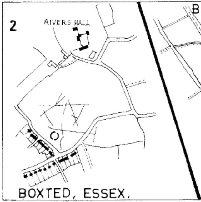
The site was only rediscovered in the 1970s and was first described in Mrs Ida McMaster’s (1975) survey of crop-marks that had been revealed by aerial surveying in Essex and Suffolk counties. Her brief account of the monument told it to be,
“A Class II henge with a wide somewhat ploughed out ditch. Various linear ditches are near, together with prolific variegated ‘field outlines’ of glacial subsoil cracking which extends into the next field southwards. The ditch terminals of the southwest entrance to the henge appear to be wider than the general run of the ditch, say 4-5 metres.”
When Harding & Lee (1987) examined the site, they were a little more cautious in their interpretation of it being a definite henge, citing that there was “insufficient information, but cannot be ruled out as henge-related,” adding that it “could also be a mill.” This latter element seems unlikely, though a windmill may have been built onto the site at a later date.
More recently however the site has been categorized by Historic England as “a Late Neolithic henge.” The monument itself was defined by a broad circular ditch with two large opposing entrances to the north and south. The total diameter of the enclosure is 44 yards (40m) across; but with the surrounding ditch measuring 5½ yards (5m) across all around, the inner level of the henge was about 33 yards (30m) in diameter. Plenty of room for partying old-style!
References:
Harding, A.F. & Lee, G.E., Henge Monuments and Related Sites of Great Britain, BAR 175: Oxford 1987.
Although cited in all modern archaeology texts as a series of four henge monuments, a recent article by J. Lewis & D. Mullin (2011) inform us that these “are not henges but belong to a tradition of enclosure that predates them and had a different function.” We’ll have to wait and see what they mean by that! In the meantime, we’ll have a quick scurry through the historical accounts of these four impressive ‘henges’ as Burl, Piggott and the others call ’em.
Surrounded at all angles by numerous barrows and tumuli, these four great henge monuments were shown on the 1887 Ordnance Survey map as a row of ‘Supposed Ring Forts’, when such ideas were in vogue, running in a line roughly SSW-NNE; the third one up having a couple of ponds within it. A brief early account of them was given by Harry Scarth (1859)—who was describing the series of nine round barrows a few hundred yards to the south—who told them to be “circular banks” each 500 feet across. The first more detailed account was in A.H. Allcroft’s (1908) classic text, where he wrote the following:
“…Close to the Castle of Comfort Inn, where the high road to Bristol crosses the line of the old Roman road running north-westward towards Charterhouse, there lies immediately west of the high road a series of four circles…all of one size, all of one plan, and all as mathematically exact as circles could well be when executed in such a soil and on such a scale. Although they have suffered greatly from the mining operations which have scarred all the Mendips, as well as from the plough — one of the four is almost obliterated — they are still quite easy to make out. The diameter of each is some 550 feet within the area, which is surrounded by a broad low vallum, and that again by a correspondingly broad and shallow ditch. The height of the vallum above the ditch, where best observable, is some 5 feet. There are no determinable entrances. The most southerly of the group is about 250 feet away from the second ; the second about 200 feet away from the third; and a line joining the centres of the first and third passes through the centre of the second also, and points 17° east of north. The fourth circle lies 1,200 feet away from the third, not in a right line with the others, but slightly to the west. Between the third and fourth circles passes the Roman road. Within the third circle is an old pond of some size.
“With every appearance of being all of one date, and that a venerable one, these circles lack every characteristic of military works. Their peculiar disposition, their painstaking regularity, and their identity of size, all suggest that they must, if really old, be of ritual, and perhaps of astronomical character”
Old drawing of the central hengesHenge 1, recently damaged (courtesy Pete Glastonbury)
Allcroft’s ideas of ritual and astronomy were pretty good for the period, as we take it for granted these days that such events occurred at henges — so the existence of four such sites right next to each other, would have made this one helluva place in neolithic and Bronze Age periods. A few years after Allcroft, the henges were described in Mr Burrow’s (1924) excellent illustrated survey, from which the drawing of the two central henges is taken (the two ‘R’s in the background highlight the line of the Roman road which runs past them). Burrow’s didn’t add much more of any note, simply telling:
“…in the fields north and south, are placed earth-work rings, each about 180 yards in diameter, on a line placed slightly north by east. The most northerly of these rings is almost obliterated, but the three on the west of the road from Chew Stoke to Oakhill are quite clearly defined, as my drawing (above) will show. I have been able to include two of these remarkable rings in my picture, the edge of the bank (which was, when I saw it, fringed with yellow gorse), being about 6 feet above the level of the ditch outside. It is generally supposed that these ringed earthworks were connected with some prehistoric ritual, and Hadrian Allcroft thinks were used for primitive astronomical observations or the construction of a primitive calendar.”
Tratman’s plan of Priddy HengesAnother view of Henge 1 (courtesy Pete Glastonbury)
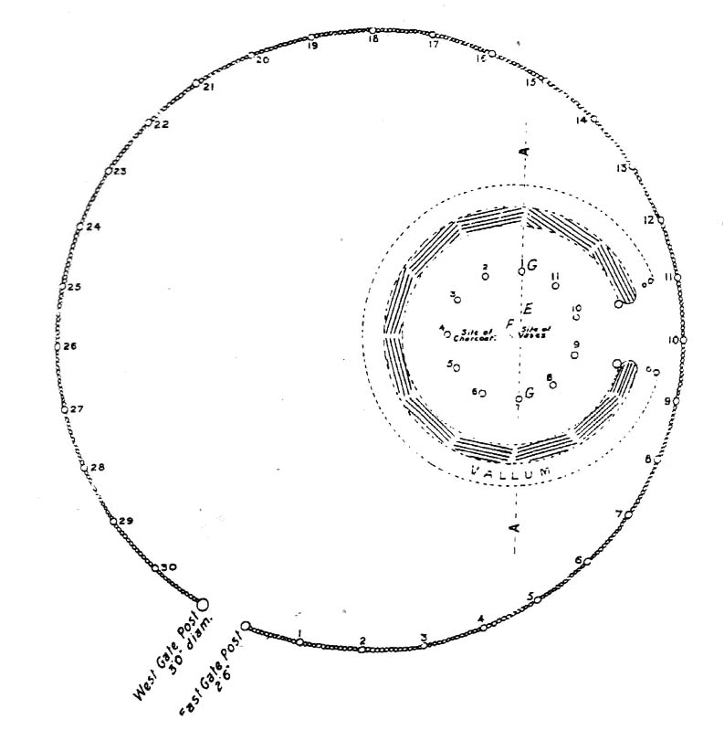
Many years later when archaeologist K.S. Painter (1964) came to describe these henges, he listed them as “stone circles” (what the hell was he on!?), but this error may derive from the finding of several stones that once existed inside the southernmost Henge 1. These were uncovered following excavation work done here by E.K. Tratman (1967) and his colleagues, who explored and numbered the four henges—running from south to north—as follows:
“Circle 1: This is tolerably complete. A portion of the southwest quadrant has been destroyed by mining and there are three modern gaps in the ring. Mining has involved the ditch on the west and south, and to a small extent on the east. There is an irregular extensive hollow west of the centre and this too is a product of mining and contains a number of large stones so derived. The circle is not quite a true one, being flattened slightly on the west. The circle has a diameter from bank top to bank top of 520ft. The single original entrance is NNE of the centre. Stones 1 and 3-7 were removed by the farmer before excavation, but subsequent ploughing immediately after removal did not reveal any change in soil texture or colour. Stone 8 was placed in its present position quite recently. It is not known where it came from. Other stones have recently been placed on top of the bank east of the entrance by the farmer (1964-5). Stone 2 is in a relatively ancient position.
Circle 2: This is a true circle and its diameter and position of its entrance are similar to Circle 1. It has been considerably disturbed by mining. A group of stones (10-14) and stone 9 represent modern collections from the field. None of them is in its original position. There are two modern gaps in the ring.
Circle 3: This is distinctly flattened on the east and west. The N-S diameter is 520ft and the E-W 490ft from bank top to bank top. The northeast quadrant reported by Allcroft as being levelled is still traceable. The circle has been greatly disturbed by mining… The entrance is SSW of the centre, the opposite pole to circle 1 & 2, and has probably been widened, perhaps by miners. The marsh may be an original feature or the product of mining. The two ponds are certainly modern, and so is a small mound, which is probably spoil from the major pond.
Circle 4: This is incomplete. It has a diameter of 560ft, which is considerably larger than any of the others. The OS map shows only the eastern semi-circle remaining. However, the bank and in part the ditch can be traced…If the visible and proved end of the ditch on the SSW was intended to be at the edge of the causeway, then the entrance would have been in the same position as that of Circle 3.”
Very recently, a local land-owner quite deliberately bulldozed a large portion of the southern henge in this complex, destroying much of it. This act of criminal vandalism will hopefully not go unpunished and is, at the present time, going through the courts.
…to be continued…
References:
Allcroft, A. Hadrian, Earthwork of England, MacMillan: London 1908.
Burrow, Edward J., Ancient Earthworks and Camps of Somerset, E.J. Burrow: Cheltenham 1924.
Lewis, J. & Mullin, D., “New Excavations at Priddy Circle 1, Mendip Hills, Somerset,” in Proceedings of the University of Bristol Speleological Society, volume 25, 2011.
Painter, K.S., The Severn Basin, Cory, Adams & Mackay: London 1964.
Scarth, Harry M., “Some Account of the Investigation of Barrows on the Line of the Roman Road Between Old Sarum and the Port at the Mouth of the River Axe,” in The Archaeological Journal, volume 16, 1859.
Tumulus (destroyed): OS Grif Reference – SE 4734 2449
Also Known as:
Mound 1 (Pacitto)
Roundhill Field
Archaeology & History
Pacitto’s plan of the tomb (after YAJ, 1969)
One of a number of sites that used to exist in this part of West Yorkshire before the coming of the Industrialists and their ecocidal ways. Found in conjunction with the Round Hill Field tumulus 53 yards to the south, this fallen monument was thankfully looked over several times before its final demise when the power station was built. The first literary account of it seems to be Forrest’s (1871) local history work, soon followed by another dig by the legendary tomb raider, William Greenwell. (1877) Both of these digs were very good indeed and give us the most detailed account of the remains here.
One of the urns found in the mound (Forrest 1871)
The name of this tumulus and the nearby Round Hill site needs some clarification before continuing to the archaeological account. In both Forrest and Greenwells’ accounts, they each named this site as the ‘Round hill tumulus’, but since their original fine work, archaeologist A.L. Pacitto (1969) and his team found the other previously unrecorded tumulus and surrounding ring-ditch in the original field called Roundhill field. Old records showed that a wall or fence once ran between the two sites, and that the tumulus which Forrest and Greenwell previously called the Roundhill site was actually located in the curiously named ‘Angel Moon field’ — hence the change of name in this (and Pacitto’s) account. (if y’ get mi drift) It’s an important point. So as you read the accounts below, where the authors describe the Roundhill tumulus, they are in fact referring to this, the Angel Moon tumulus. Gorrit? OK!
The site was noted for the first time as a tumulus by the local owner of the land here, a Mr Hall, in 1811, who wanted it levelled and attempted,
“to remove it altogether, but so many human bones were then met with, that after removing a considerable portion, it was abandoned, and the exhumed bones removed to the neighbouring churchyard of Ferryfryston.”
Mr Forrest then said:
“We are told by an eye-witness that on this occasion two plates of metal were found, but of what kind of metal pr what became of them we have no certain information.”
Thereafter began Forrest’s lengthy account of the initial excavation of the Angel Moon burial mound, undertaken (I think) by himself and other locals. Readers will hopefully forgive the lengthy profile I’ve given this place, but I know it will be of interest to local historians in the Pontefract and Ferrybridge area:
“This Tumulus, which is situated in Roundhill Field, on the left of the road leading from Ferrybridge to Castleford was first opened on March 28th, 1863. For the sake of ascertaining its structure, a trench was dug on the side not previously disturbed, to within a few feet of the centre, but without result, except ascertaining that the material gradually changed from sandy gravel to large stones as the middle was approached, and that it had been raised upon a natural swell of the strata, thus offering a dry situation; a condition about which the ancients appear to have been solicitous in choosing the sites of their sepulchral mounds. They then began to dig at the top, and immediately under the sod lay two human skeletons, one upon the other, with no more than six or eight inches of soil upon them. Near them lay portions of two antlers of…red deer, the uppermost skeleton was that of a tall adult male, the teeth nearly entire and in fine preservation, the other was of shorter but stouter proportions, the feet of both were gone, probably by the diggers in 1811, who it is conjectured had previously discovered these remains, and covered them up, with the few inches of soil, under which we found them; they had evidently not been removed, all the bones present being in their natural position, the whole of the bones and horns were much crushed and broken by the superincumbent earth which must once have covered them.
“With them were found several detached pieces of what appeared to have been the tusk of some animal, probably the wild boar, and fragments of half-baked pottery which on comparison were found to be portions of two urns of the early British type, such as are usually found in grave-hills attributed to that period. The smaller one (of which the principal portions were recovered) was of the size and much of the shape of an ordinary breakfast cup, three inches high, scored all over with vertical indentations as if by a piece of flint. The other was much larger, more elegant in shape, on which considerable taste was displayed in the ornamentation, composed of parallel lines, chevrons, zigzags and punctures, in which a dextrous use of the twisted thong was evident; this was ten inches high.
“About eighteen inches to the left of these, and a few inches deeper, lay the skeleton of another person, who had evidently lived to a great age, the teeth being worn nearly to the roots, tho’ showing no signs of decay. All the three lay east and west as in the present mode of Christian sepulture. No other human or animal remains were found, nothing metallic, or any implements, no appearances of cremation, no ashes, neither did the urns appear to have contained any, no stones to indicate that a cist had enclosed them, they had been buried in the soil, which here only differed from that surrounding it, in its somewhat darker colour.
“Digging downward, immediately under the skeletons first discovered, a large rough slab was reached at the depth of four feet from the surface. Its removal disclosed a stone cist or grave, of which it had formed the cover, composed of four rough stones set on edge, and paved with smaller pieces at the bottom; width at the head 2 feet, at the feet 1 foot 5 inches internal dimensions. It was entirely filled with small gravel, in which was interred the skeleton of an adult male, apparently of large stature, the thigh bones measuring in length 19¾ inches, the leg 16 inches. The knees were bent up in the manner in which such interments are usually found, and the face toward the south. The skull was accidentally broken, but well developed, and indicating the age about forty. The teeth were all present, and in beautiful preservation, the enamel white and bright as in the living subject. In front of the breast was an urn, laid on its side, of very coarse make, imperfectly baked, and so fragile, that on the most careful attempt to remove it, the urn crumbled into fragments, the whole was however collected, and sufficed to give a correct idea of its size, shape and ornamentation. It contained nothing but small gravel, like that in which it was laid. Near it was a small chipping of flint with a cutting edge, 2½ by 1¼ inches, this was the only article having any resemblance to a tool or implement hitherto met with.
“The cist being filled with gravel, I suppose to be an unusual circumstance. It could not have penetrated through any fissures in its sides, neither was the cist likely to have been opened subsequently, as nothing appeared to have been disturbed.
“Proceeding downward, it was seen that this cist was built upon and its sides supported by large rough stones inclined towards it ; the surrounding gravel was mixed with fragments of human bones, small pieces of urns, and occasionally bits of charcoal, and in a cavity a piece of wood was found but so decayed that its original shape or purpose could not be ascertained. Among the bones was a portion of a skull, showing a fracture from which the subject had recovered.
“At about the depth of seven feet, and a little to the east was a flat stone laid horizontally, length 4½ feet, width 3 feet, under this was a layer of dark earth two or three inches thick, totally different from that surrounding it, inodorous, and in which was no perceptible trace of animal remains, but exhibiting hollow casts of something resembling stone fruit about 1 inch long by ½-inch wide. Near this was found a thin stone of a round or oval shape about 6 inches broad, apparently chipped to shape and having a rough cutting edge ; its use can only be conjectured.
“At the depth of nine feet, the native rock was reached in which was a cavity about ten inches deep, but as far as could be ascertained containing nothing but gravel mixed with bones like the surrounding part.
“From observations then made I came to this conclusion: that the mound had been used for interments anterior to the formation of the cist, on which occasion, its upper part was levelled to make a convenient platform for it ; when the bones of former interments were disturbed and scattered about with as little respect for the dead as would a modern gravedigger; in making room for a new occupant.
“The fact of the three skeletons first noticed being interred after the Christian mode, is presumptive evidence that they were Saxons. It is well ascertained that this people had their coming here, frequently buried their dead in British tumuli, even after they had embraced Christianity, which occasioned an edict to be published in the year 987, prohibiting this practice, and providing that no Saxon should be buried in the tumuli of the Pagans, but only in the cemeteries of the churches, neither do urns nor antlers (which are undoubtedly British) militate against this supposition, when it is considered that they were all fragmentary, and as the skeletons with which they were, had evidently been disturbed though not removed, it is very probable that these fragments had been taken from that part of the mound removed in 1811, and thrown among these bones in the random manner in which we found them.
“From all these circumstances, this barrow appears to have had a very early and prolonged existence as a place of sepulture. The cavity in the rock was probably the grave of the first interment. The fragments of bones under and around the cist show that interment had taken place before its formation. The absence of any evidence of cremation either in the cist or elsewhere, shows that these interments were prior to the introduction of that ceremony from the nations with whom the Britons afterwards had intercourse. The absence of any weapon or other instrument save the single chipping of flint, and the roughly fashioned stone and the rudely found urn of clay, all go to prove that this was one of the very earliest of British Barrows. And if my hypothesis as to Saxon burial be admissible it will bring its sepulchral history down to the Christian era.
“At the upper end of the field are some earthworks of considerable depth, but as the whole is under cultivation, their form and purpose can scarcely now be determined.”
A few years later the legendary tomb raider Mr Greenwell and his mates turned up and gave the site their additional attention.
“On this occasion the digging commenced on the east side, where a deposit of burnt bones was found upon a flat stone just above the surface, and ten feet from the outside. Six feet to the north of this was another similar deposit laid upon the natural surface. Five feet south of the centre, was an unburnt body, doubled up and on its right side, with its head to the south. Immediately beneath, and in close contact with it, was a burnt body, apparently deposited at the same time. These interments in opposite customs present very interesting features in British sepulchral usage, as if the practice of cremation though at one period generally adopted, was not universal, but influenced by the wish of the deceased, or the inclination of surviving friends. With these remains were found an urn, of beautiful type, 4½in high, ornamented outside with twenty-seven thong markings, it would be impossible to decide to which of the bodies this belonged, such urns are found with both modes of burial.
“These deposits of burnt bodies were all found on the south-east side of the tumulus and consequently none were met with during the partial examination in 1863; but as the diggers in 1811 commenced at that point, they must have found and removed several such.
“As the work proceeded, the large flat stone covering the deposit of dark earth, was again met with ; and southward of this was another similar deposit also covered by a stone. In this earth was found a small seed pod or fruit, with striated markings, about nine lines in length, and black as the soil in which it was found ; its size and shape suggest the idea, that such fruit might have been the occasion of the hollow cists observed in the first discovered deposit. Close to these deposits was one of very dark sand, inclined to dark red or chocolate colour in some parts, this had evidently been subjected to the action of fire.
“The tumulus was so far removed, as to reveal the nature of the surface on which it had been built, which proved to be a natural outcrop of the limestone rock, and upon it these dark deposits were found. Their origin and purpose, offer an interesting subject of enquiry to the Archeologist. Their situation on the edge of the projecting rock is suggestive of their sacrificial character, or their connection with some of the druidical rites of the ancient Britons. The burnt sand may mark the site of the place where the act of cremation had been performed.
“The next object of interest was the rock grave, the edge of which had been reached in 1863, but reluctantly abandoned. This was found, and proved to be a large circular one, nearly six feet in diameter, and two feet six inches deep. At the west end was a rudely-formed cist, filled with gravel like the first one, in which was found a body, bent up in the usual manner, lying on its right side, and with its head to the south-west. At its feet was a drinking cup laid on its side, height seven inches, profusely ornamented with thong markings, consisting of three sets of horizontal lines filled up between with vertical lines, below these, and between two more horizontal lines, was a line of zigzags, the lower triangles of which were filled up with horizontal markings. The same pattern occupied the upper and lower halves of the vase. In the hollow of the knees was found a bronzed pin much oxydized, about 1½in. long, this might have been used to fasten some portion of the dress in which the person had been buried. It was the only piece of metal found in the tumulus, with the exception of that found in 1811, which is now supposed to have belonged to an Anglo-Saxon, buried with sword, spear, shield, etc.”
Then in 1962 came the final examination here, shortly before the site’s destruction. Pacitto (1969) and his team didn’t really find much more than his Victorian predecessors, apart from a couple of flints, some other fragments of bones and some modern bits and bats. However,
“The mound was surrounded by two concentric ditches, respectively 55ft and 75ft in diameter. The outer ditch was only a few inches deep, but the other had been cut into the limestone (my italics, PB) to a depth of 2ft 6in”
References:
Forrest, C., The History and Antiquities of Knottingley, W.S. Hepworth: Knottingley 1871.
Greenwell, William, British Barrows, Clarendon Press: Oxford 1877.
Pacitto, A.L., “The Excavation of Two Bronze Age Burial Mounds at Ferry Fryston in the West Riding of Yorkshire,” in Yorkshire Archaeological Journal, volume 42, part 167, 1969.
Roberts, I. (ed), Ferrybridge Henge: The Ritual Landscape, WYAS 2006.
In Grassington, go up the main street and keep going uphill, out of town. You’re on Moor Road now and it keeps going northeast for about a mile, where the small copse of trees grows just before Yarnbury House. However, on the other side of the road (right) two field before you reach the house, you’ll notice a slightly raised elevation in the field, close to the wall. A footpath runs right past it, so you shouldn’t have too much trouble finding it!
Archaeology & History
This is a fine, roughly circular neolithic monument, sat not-quite-on-the-heights, but still possessing damn good views all round (except immediately west), begging the question, ‘what on earth are you and why were you built here?’ Answers to which, we don’t really know. But ascertaining its geomantic nature wouldn’t be too difficult for local people who have spent years visiting the site. John Dixon (1990) mentioned how, in the winter months,
“the sun falls behind Pendle (Hill) providing it with a sky-red backdrop. In my own view the site is related to the presence of Pendle…and may have been the major factor in the location of the monument.”
He may be right! It has been suggested by one archaeologist (King et al, 1995) that the site was “most probably a wood henge” with upright rings of wooden posts that were built onto the central platform — but until we get a full dig here, we’re not gonna know.
N-NE section of hengeSW section of the henge
Found close to an extensive amount of other prehistoric remains in the area (dating from the neolithic to Iron Age), this henge monument is notable for its size, as it’s only a little fella! It’s like a mini-version of the Castle Dykes henge near Aysgarth, 14 miles to the north! First mentioned as a ‘disc barrow’ in 1929, J. Barrett (1963) added the Yarnbury Henge to the archaeological registers 32 years later, citing it as a “circular platform 60-63 ft diameter, surrounded by a ditch 20ft wide (crest to crest) and an outer bank.” A couple of years later D.P. Dymond (1965) described the henge in slightly more detail, telling:
“At Yarnbury, just over one mile north-east of Grassington there is an earthwork 116ft in diameter overall, consisting of a ditch with external bank. On surface inspection the earthwork appeared to have the characteristics of a henge monument. An excavation carried out in July 1964 , by an archaeological summer school based on Grantley Hall, proved this thesis. There was no trace of an internal mound and the entrance to the southeast was obviously original. No traces were found of any sort of internal structure, and a square pit in the centre of the circle had been caused by an excavation earlier this century. The ditch was rock-cut and the bank of simple dump construction. No dating evidence was found… With its single entrance the Yarnbury henge falls into Atkinson’s Class 1.”
SW area of the henge
In recent years it seems that some damage has been done by digging into the east and southeastern sections of the henge. Summat we hope doesn’t get any worse. In the field on the other side of the road we found traces of prehistoric enclosure walling (along with a curious, large, almost cursiform shadow, 44 yards across and running 110 yards NE), typical of the extensive settlement remains found less than a mile away at Lea Green and High Close Pasture, Grassington. It’s an impressive area, well worth checking out!
References:
Barrett, J., “Grassington, W.R.,” in Yorkshire Archaeological Journal, part 161, 1963.
Dixon, John & Phillip, Journeys through Brigantia – volume 2: Walks in Ribblesdale, Malhamdale and Central Wharfedale, Aussteiger Publishing: Barnoldswick 1990.
Dymond, D.P., “Grassington, W.R.,” in Yorkshire Archaeological Journal, part 163, 1965.
Harding, A.F., Henge Monuments and Related Sites of Great Britain, BAR 175: Oxford 1987.
Harding, Jan, The Henge Monuments of the British Isles, Tempus: Stroud 2003.
King, Alan, et al, Early Grassington, Yorkshire Archaeological Society 1995.
Wainwright, G.J., “A Review of Henge Monuments in the Light of Recent Research,” Proceedings of the Prehistoric Society, volume 35, 1969.
Very close to the once impressive Dorchester Cursus, this double-ringed prehistoric monument can no longer be seen thanks to the self-righteous arrogance of modern industrialists who care little for the ancestral monuments of the British people, destroying all traces of the site — an activity which, in this case, astonishingly started in more ancient times, as Jean Cook (1985) told: “The banks and the ditches had been levelled through agricultural activity, possibly in the Iron Age”!
Big Rings ground-plan1938 photo of the Big Rings, by Major George Allen
The destruction of this environment continues to this day, destroying many important archaeological remains with little care. Thankfully we we’ve got a good account of the site due to the archaeological excavations of R.J.C. Atkinson (1951) and his team in the late-1940s, from whom Cook and just about everyone else gets most of their data regarding the site.
The Big Rings Henge was probably built sometime in the middle of the second millenium BC. It was an important prehistoric ritual site and, most likely, had some relevance to the adjacent cursus monument. A number of important mortuary and ritual sites were also built close to the site over a period of nearly two thousand years, showing the importance this landscape had to our ancestors.
Jean Cook (1985) described the Big Rings henge as follows:
“The ditches, of which there were two, had opposed entrances on the NNW and SSE. They were about 7.6m wide and 1.8m deep with flat bottoms. Originally there seems to have been a broad low bank on the inner side of each ditch. The southern entrance incorporated an existing monument, consisting of a ring ditch which enclosed a large four-post setting and contained a cremation and a stone axe. Just outside the north entrance was a round barrow, containing a central oval burial pit which produced a crouched inhumation, together with a well-preserved beaker, two small copper or bronze knives and a rectangular wrist-guard of greenstone. The Big Rings ditches themselves contained pottery belonging to the middle or late Beaker period. Although the area within the ditches was trenched, there was no evidence of internal timber structures.”
References:
Atkinson, R.J.C., “The Henge Monuments of Great Britain,” in Atkinson, Piggott & Sandars’ Excavations at Dorchester, Oxon (Department of Antiquities: Oxford 1951).
Atkinson, R.J.C., Piggott, C.M. & Sandars, N.K., Excavations at Dorchester, Oxon, Department of Antiquities: Oxford 1951.
Cook, Jean, “The Earliest Evidence,” in Dorchester through the Ages, Oxford University 1985.
Harding, A.F., Henge Monuments and Related Sites of Great Britain, BAR 175: Oxford 1987.
Harding, Jan, The Henge Monuments of the British Isles, Tempus: Stroud 2003.
Wainwright, Geoffrey J., The Henge Monuments: Ceremony and Society in Prehistoric Britain, Thames & Hudson: London 1989.
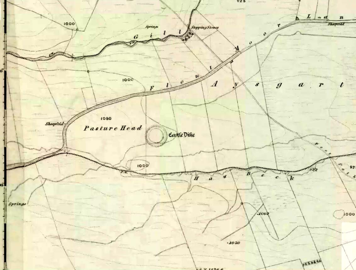
Go west through Aysgarth village along the A684 road and, just as you’re coming out of the town, take the left turn on the Thornton Rust road, past Town Head Farm, and turn left up the track (called Folly Lane). Go past the house where the track veers to your right and follow it straight on (don’t turn up the track on your left a short distance along). Keep walking on here for nearly a mile (about 10 mins), keeping your eyes peeled for the embanked rise in the field on your left, which is where the henge can be found! You’re damn close!
Archaeology & History
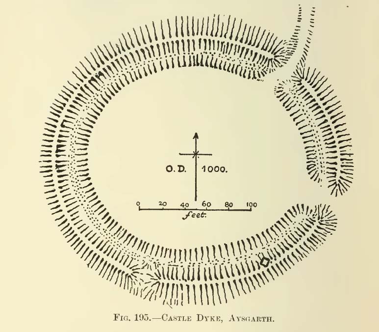
A.H. Allcroft’s 1908 plan
One of the earliest accounts I’ve found describing the Castle Dykes henge is in Mr Barker’s (1854) lovely literary exploration of Wensleydale, where he describes, “on Aysgarth Moor, which is now enclosed, may be seen a circular encampment, probably Danish” in origin. But he tells no more. When Edmund Bogg (c.1906) came here fifty years later, he added little extra, simply telling of, “the earthworks known as ‘Castle Dykes’, probably Angle or Danish, although Roman relics have been found here.” However, the brilliant Mr Speight (1897) gave what seems to be the earliest real description of the site when he described “the Celts” and the earliest settlers of the region, saying how:
“The so-called ‘Castle Dykes’ at Aysgarth betrays a probable connection with the same settlers. It is an irregular circular rampart, measuring about forty yards across its longest diameter, and not unlike the earthwork on Harkaside called ‘Maiden Castle’… A ditch completely encloses the mound, which, it should be noted, is unusually low, being little higher than the outer bank or upcast from the trench. It is totally different from the elaborate burh at Middleham; indeed, from its low and simply form, as well as from its situation in Celtic territory, there seems little doubt that it was the work of these early people.”
Ditch of Castle Dykes henge, looking east (photo credit – Richard Stroud)
Speight also made a suggestion that the place-name of Aysgarth itself may derive from this monument. He may have a point. A.H. Smith (1928) and other place-name authorities tell the name to derive from “an open space” either surrounded by, or — in some way — defined by oak trees. We might never know for sure…
Not long after the works of Speight and Bogg came the first real survey of British prehistoric earthworks by A.H. Allcroft (1908) — and amidst the mass of archaeological curiosities (as many were at the time) was another description of this great ceremonial monument. Allcroft told that here,
“a weak vallum of earth encloses a perfectly regular oval area measuring from crest to crest of the vallum 257 feet (east to west) by 217 feet (north to south). Immediately within the vallum is a broad fosse varying from 25 to 32 feet in width. The vallum at its highest (east) rises not more than seven feet above the floor of the fosse. The “island” measures 196 by 160 feet and is perfectly flat. There is no berm and no outer fosse. The vallum is broken by three gaps, of which that to the southeast is apparently original, as the fosse has never been excavated across it. The other gaps point respectively northeast and south-southwest, the latter being a mere depression like that to be seen at the eastern side of the northern ring at Thornborough. At one point in the vallum, on the southeast, a single large stone rises slightly above the turf which otherwise covers the whole work, and certain depressions observable at other points suggest that other such blocks have been removed —that, in fact, it originally had a peristalith standing upon the vallum. The principal entrance looks towards Pen Hill…”
Around the same time, the early scientific discipline of astroarchaeology was taking root and in Sir Norman Lockyer’s Nature journal, the reverend J. Griffith (1908) explored the potential astronomical orientation of Aysgarth’s Castle Dykes, thinking that the main entrance to the site gave indications of an alignment towards either Alpha Centauri or Capella. Y’ never know…
Although many visitors and local people knew of Castle Dykes, it was pretty late before the site gained status as a henge monument. This happened following a visit here by the pedantic archaeologist R.J.C. Atkinson (1951) in September of 1948. Following his visit, Atkinson described the place, saying:
“It consists of an oval enclosure bounded by a well-preserved ditch and external bank, with an entrance on the East side. Two small gaps in the bank, without corresponding causeways across the ditch, were probably made in recent times to allow the escape downhill of the surface water which collects in the ditch. The dimensions in H. Allcroft’s plan are incorrect. The markedly oval shape is probably in part dictated by the situation, in order that as much as possible of the enclosed area should lie on the level ground topping the ridge. There is no sign of any stone structure in the central area, but the district abounds in stone walls, for which the site may have been robbed in the past.”
Aerial image
In more recent years, archaeologists have speculated that the site was a sacred site or meeting place, aswell as a site where trade occurred, particularly a place where axes were traded; but this latter idea is more due to the projection of a modern religious notion, of ‘The Market’ with little veracity in terms of the site’s function. This increasing imposition of ‘economics’ and ‘trade’ (see Brown 2008:44-6) as vital ingredients to this and other sites has little relevance outside of a simple epiphenomenalistic adjunct to magical and tribal exchanges. But such notions are outside of archaeological frameworks, so we shouldn’t be surprised at so prevalent an error.
But this place is damn impressive — though with the exception of Mr Griffith, one notable ingredient archaeologists seem to have forgotten about was the position of this site in the landscape. The views surrounding the henge are excellent, giving a 360° arena all round. If the monument once had a ring of stones around it, as Allcroft suggested, the views would still have been the same. A modern excavation here might prove worthwhile and, as a result, open up once again, the potential for further astronomical investigations with the many hills and notches along the living horizon. This site, whilst requiring analysis of it as a ‘specimen’, must also be placed in the context of the wider living environment which, to all early traditional cultures, were such important and integral ingredients.
We have also found some previously unrecorded prehistoric remains nearby which, hopefully, we’ll be able to explore a little more in 2011 and report here.
…to be continued…
References:
Allcroft, A. Hadrian, Earthwork of England, MacMillan: London 1908.
Atkinson, R.J.C., “The Henge Monuments of Great Britain,” in Atkinson, Piggott & Sandars’ Excavations at Dorchester, Oxon (Department of Antiquities: Oxford 1951).
Barker, W.G.M.J., The Three Days of Wensleydale, Charles Dolman: London 1854.
Bogg, Edmund, Wensleydale and the Lower Vale of Yore, E. Bogg: Leeds (c.1906).
Brown, Paul & Barbara, Prehistoric Rock Art in the Northern Dales, Tempus: Stroud 2008.
Griffith, Rev. J., “English Earthworks and their Orientation,” in Nature, volume 80, 18 March 1909.
Harding, A.F., Henge Monuments and Related Sites of Great Britain, BAR 175: Oxford 1987.
Smith, A.H., The Place-Names of the North Riding of Yorkshire,Cambridge University Press 1928.
Speight, Harry, Romantic Richmondshire, Elliot Stock: London 1897.
Acknowledgements: Many thanks to Richard Stroud for use of his photo of the henge.
Bleasdale Ring & enclosure plan (Syd Wilson, 1900)
Pretty easy to find, and a nice walk to boot! Head up to Bleasdale Church (worth a look in itself!), keep going up the path north to the aptly named Vicarage Farm. From here you’ll notice a small copse of trees on your left (east) heading to the hills. To those of you who like Predator, “it’s up there – in them trees…!”
Archaeology & History
On my first visit here in the company of John Dixon and other TNA regulars, my first impression was “this is a henge” – and noted subsequently that it’s been described as such by several writers. But the general category given to this fascinating place is a ‘timber circle.’
Bleasdale ‘henge’ circle
First discovered at the end of the 19th century and described in considerable detail by Mr Dawkins (1900), this is a gorgeous-looking monument was erected in at once a gentle and tranquil, aswell as an imposing natural setting, at the foot of Fair Snape Fell (to the northwest) and Bleasdale Fell (due southwest). These aspects of the landscape would have had obvious mythic importance to the people who built this ring amongst the trees. A condensed version of Dawkin’s material was described in J. Holden’s (1980) Story of Preston, that outlined this circle as being,
“a centre for religious worship in about 1700 BC. It was made up of a circle of timber posts which enclosed an area 45 metres in diameter. In the centre was a small mound surrounded by a ring of oak posts and a circular ditch. Inside the mound there was a grave that had in it two pottery urns filled with human bones and ashes. Examination of the contents of these urns shows that the bodies were wrapped in linen and burnt on a funeral pyre. A small ‘accessory’ cup was found inside one of the urns and this may have contained food or drink for the afterlife.”
Urns from Bleasdale Ring1898 photo of Shadrach Jackson (left) & Tom Kelsall (centre) digging the site
Located within a much larger circular enclosure, the internal Bleasdale ‘henge’ Ring consisted of a small circle of eleven timber posts near the edge of the ditch, and an entrance way to the east, to or from which was an avenue of further wooded posts that led to the edge of the larger enclosure. It gives the impression that this was some sort of avenue along which a ceremonial procession may have took place, strongly suggesting a ritual function. Robert Middleton (1996) told that,
“The post circle and barrow appear to respect each other (in date), whilst the enclosure may be later. The post circle has been dated to around 2200 BC, although the context and reliability of this date is unclear.”
Looking out eastwards from the middle of the internal henge-style ring and through the ‘entrance’ we find an alignment with a large notch on the skyline which, modern folklore ascribes, is where the midwinter sun rises — which is very believable, but I aint seen it proven anywhere yet.
A much greater and full excavation report of this site was written by Raymond Varley (2010), whose essay I urge fellow antiquarians to read.
References:
Dawkins, W.B., ‘On the Exploration of Prehistoric Sepulchral Remains of the Bronze Age at Bleasdale,’ in Transactions of the Lancashire & Cheshire Antiquarian Society, volume 18, 1900.
Dixon, John, Journeys through Brigantia – volume 8: Forest of Bowland, Aussteiger Publications: Barnoldswick 1992.
Edwards, Ben, “The History of Archaeology in Lancashire”, in Newman, 1996.
Gibson, Alex, Stonehenge and Timber Circles, Tempus: Stroud 1998.
Holden, Jennifer (ed.), The Story of Preston, Harris Museum: Preston n.d. (c.1980)
Middleton, Robert, “The Neolithic and Bronze Age,” in Newman, 1996.
Newman, Richard (ed.), The Archaeology of Lancashire, Lancaster University 1996.
Sever, Linda (ed.), Lancashire’s Sacred Landscape, History Press: Stroud 2010.
")
")

")