Chambered Cairn (destroyed): OS Grid Reference – NS 58 76
Also Known as:
Blochairn 2
Canmore ID 44421
STR 3 (Henshall)
Archaeology & History
Close to the ruined Craigmaddie Muir cairn could once have seen a companion, of roughly the same size and structure and made up of thousands of small stones, covering a long internal chamber. It was described in David Ure’s (1793) early history work on the area which, even then, thanks to “frequent dilapidations, will soon be annihilated.” The cairn was included in A.S. Henshall’s (1972) magnum opus in which she wrote:
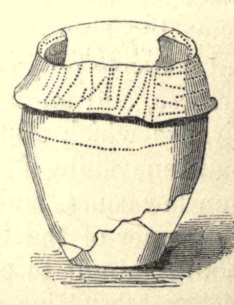
“There was a second cairn in the vicinty of Craigmaddie Muir I. It was also ‘of an elliptical shape.’ Writing in 1793, Ure says that it ‘was laid open last year, and, though not so large as the other, was of the same construction, which seems to be Danish. Some of the stones placed in the rows at the bottom are considerably large… Among the contents, upon opening…were urns… One of the fragments of an urn is ornamented, near the mouth, with two shallow grooves. The diameter of the circle of which it is a segment seems to have been at least 20in.”
Fragments of human bones were also found within the site, but the entire cairn was sadly destroyed a long time ago. In the Stirlingshire Royal Commission report (1963:1) it was speculated that the urn found herein,
“must have been either a neolithic vessel or a cinerary urn. In view of the method of construction of the chamber it may be assumed that both cairns were related to the Arran or Clyde-Carlingford types.”
References:
Henshall, Audrey Shore, The Chambered Tombs of Scotland – volume 2, Edinburgh University Press 1972.
Royal Commission on the Ancient & Historical Monuments, Scotland, Stirlingshire – volume 1, HMSO: Edinburgh 1963.
Ure, David, The History of Rutherglen and East Kilbride, Glasgow 1793.
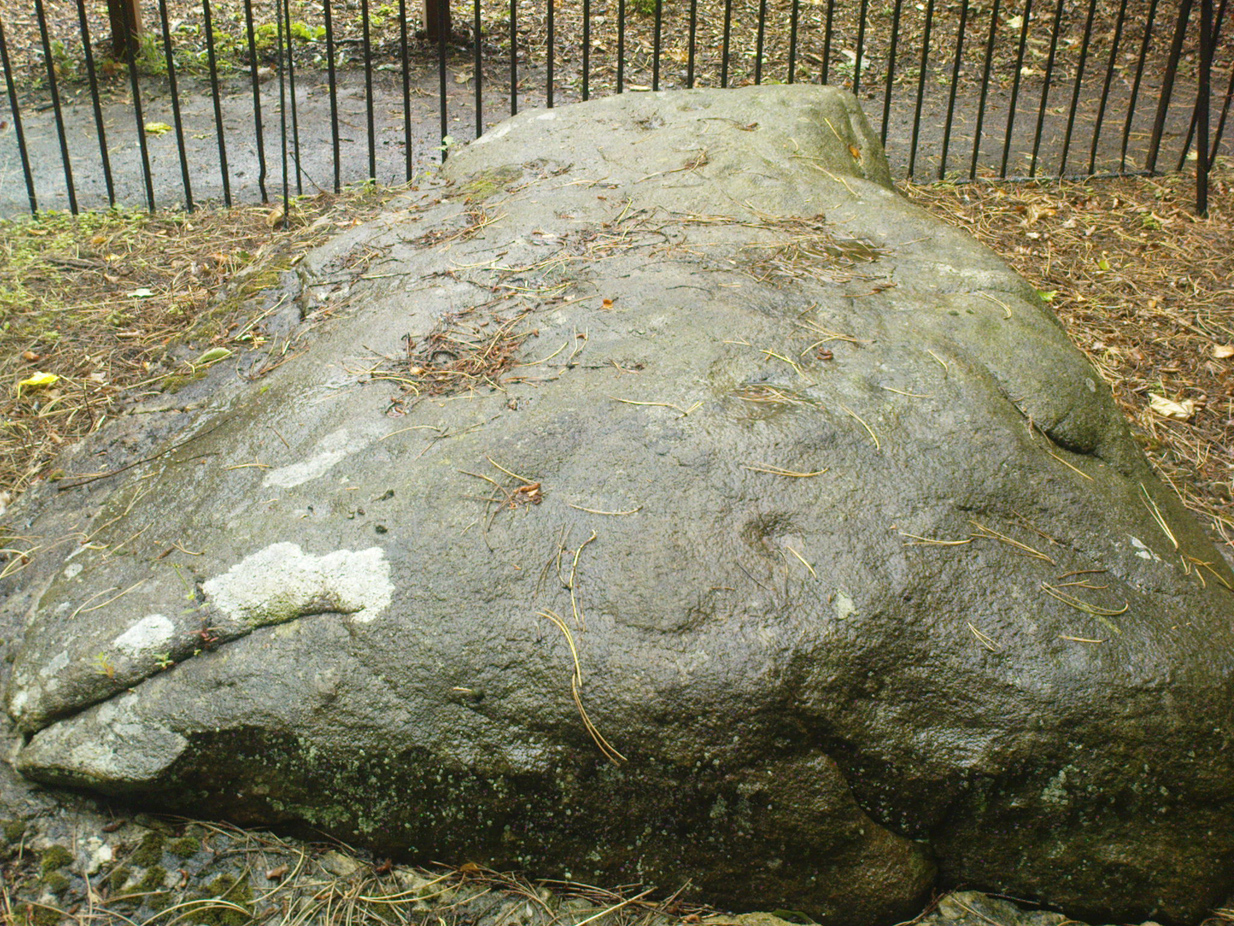
From Cow & Calf Hotel head onto the moor above you, following the same directions to reach the ornately carved Idol Stone (and its immediate companions). Ahead of you on the same footpath, about 100 yards along, as it begins to slope up the hill further onto the moor, you’ll see a large upright pyramid-shaped stone, about 8 feet all, right at the side of the path. Y’ can’t miss it!
Archaeology & History
Deep cups & lines on top
Although ascribed as a cup-marked stone in usual surveys, the cup-markings on top of this rock are seemingly Nature’s handiwork. There is a possibility that cup-markings were carved into the top of the stone, many thousands of years ago, but due to the centuries of wind and weathering, we cannot in anyway assess the curvaceous bowls and lines running across and from the top of this rock to be artificial.
Folklore
The name ‘Idol Stone’ seems to have come about as a result of the judaeo-christian Victorian obsession of satanic idolatry in all things natural – which many of them still fear. Sadly there are no early accounts of practices of idolatry at this rock, until it was used by chaos magickians in the formative years of that Current in the 1980s.
References:
Bennett, Paul, The Old Stones of Elmet, Capall Bann: Milverton 2001.
Boughey, K.J.S. & Vickerman, E.A., Prehistoric Rock Art of the West Riding, WYAS: Leeds 2003.
Forrest, C. & Grainge, William, A Ramble on Rumbald’s Moor, among the Dwellings, Cairns and Circles of the Ancient Britons, W.T. Lamb: Wakefield 1868-9.
Hedges, John (ed), The Carved Rocks on Rombald’s Moor, WYMCC: Wakefield 1986.
Holmes, J., “A Sketch of the Prehistoric Remains of Rombald’s Moor,” in Proceedings of the Yorkshire Geological Society, volume 9, 1887.
Speight, Harry, Upper Wharfedale, Elliott Stock: London 1900.
Follow the same directions to find the Balfarg Stone Circle. From the A92 going north from Glenrothes, turn E onto the country lane to Star and Kennoway. 100 yards on there’s a sign for Balbirnie; turn right here and about 200 yards on, where the road bends right, the circle’s just below you). This carving is perched on its side in one of the preserved grave cists within the circle, easily visible at ground level.
Archaeology & History
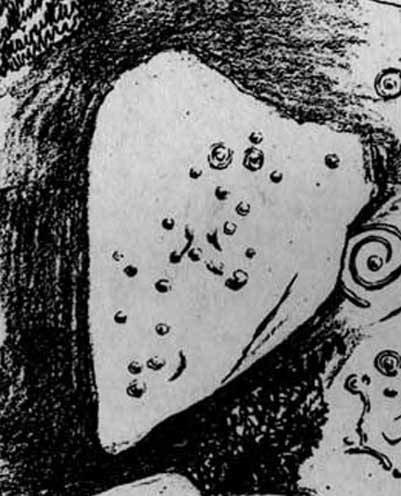
This carving (and its adjacent compatriot) was found insidethe Balbirnie stone circle when it stood in its original position more than 100 yards northwest of the place it presently occupies (at NO 2850 0304). Thankfully, when the megalithic ring was moved and reconstructed, its original status was kept, including the repositioning of this impressive small cup-and-ring stone – despite it being a copy of the original.
Early photo of the carving
Like a good number of prehistoric tombs, this small carved stone was stood on edge, facing into the stone-lined tomb (cist), obviously representative of some important element in the Land of the Ancestors: perhaps a map of the landscape therein; perhaps a personal token; perhaps indicative of the spirits of the dead; perhaps a magickal amulet for safe guidance. There are a number of ritual possibilities here, and whichever it was, we can be sure the symbols were representative of the animistic cosmology of the neolithic people living hereby, linking the living with the dead.
As you can see from the original photograph, a number of cup-marks along the edges of the stone are accompanied by two or three cup-and-rings, one of which is very faint. Some carved lines run between some facets of the carving, linking one mythic element to another. Ron Morris (1981) described the carving, simplistically, as,
“Under a cairn, within a ring of stones, one of 5 cists had, carved on the inside of a side-slab (sandstone), ¾m by ½m by ¼m (2¾ft x 1¾ft x ¾ft): 2 cups-and-one-ring—one faint and incomplete—and also 8 cups, 2 with ‘tails’. Greatest diameter of ring 12cm (5in), and carving depths up to 2cm (1in).”
References:
Burl, Aubrey, Rings of Stone, BCA: London 1979.
Morris, Ronald W.B., The Prehistoric Rock Art of Southern Scotland, BAR: Oxford 1981.
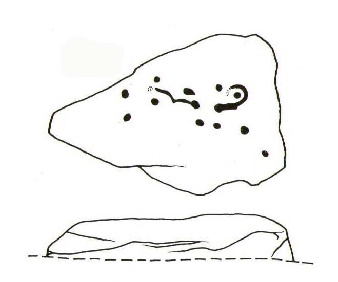
This carved stone is now held in one of the museums. To get a better idea of its original locale, take the directions to reach the Balfarg Stone Circle (from the A92 going north from Glenrothes, turn E onto the country lane to Star and Kennoway. 100 yards on there’s a sign for Balbirnie; turn right here and about 200 yards on, where the road bends right, the circle’s just below you) and look at the small stone-lined tombs (cists), within which this carving was first found.
Archaeology & History
This carving (and its adjacent compatriot) was first found within the Balfarg stone circle that originally stood more than 100 yards northwest of the site it now occupies (at NO 2850 0304). Found inside the edge of another prehistoric stone-lined tomb (cist) within the stone circle, the small elongated stone possessed at least 16 singular cup-marks along one flat face of the rock. Two adjacent cup-marks may be linked by a small line running between them. As you can see in the old photograph here, most of the cups run in two parallel lines, similar to the primary feature found on the more famous Idol Stone on Ilkley Moor.
Described in association with the Balbirnie 1 carving by Ronald Morris (1981) as simply, “a slab in another cist (with) cup-marks,” like its partner just a few yards away this carving was again representative of some important mythic element in the Land of the Dead to the person whose body was laid here.
References:
Morris, Ronald W.B., The Prehistoric Rock Art of Southern Scotland, BAR: Oxford 1981.
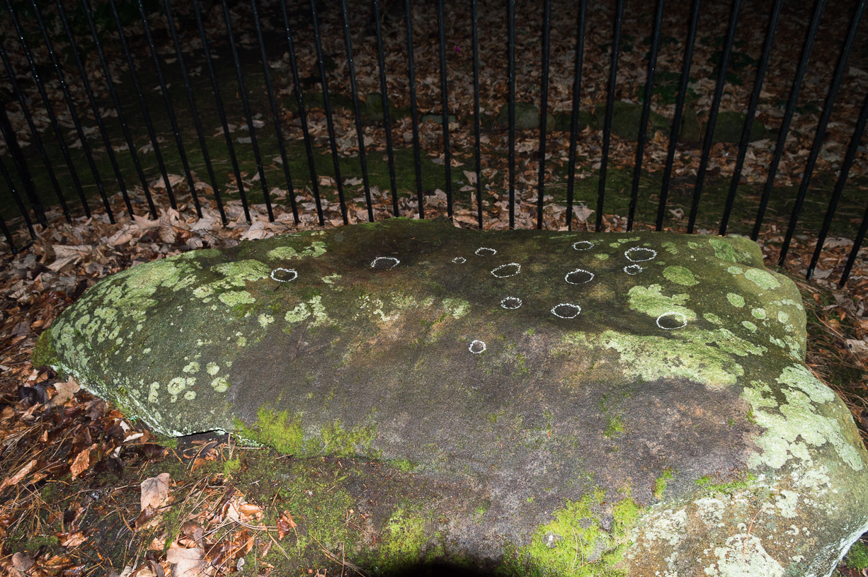
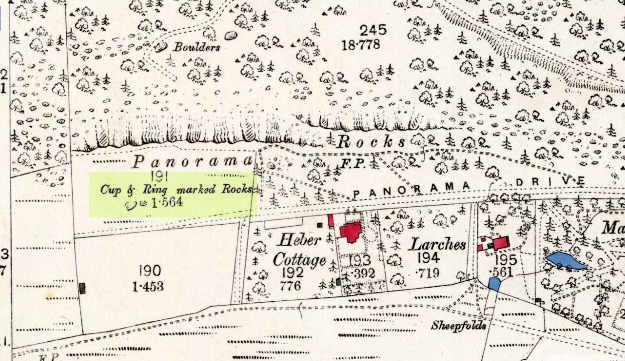
Come out of Ilkley/bus train station and turn right for less than 50 yards, heading left up towards White Wells. Go up here for less than 100 yards, taking your first right and walk 300 yards up Queens Road until you reach the St. Margaret’s church on the left-hand side. On the other side of the road, surrounded by trees is a small enclosed bit with spiky railings with Panorama Stones 227, 228 and 229 all therein: the least-decorated one on the left being the one we’re dealing with here.
Archaeology & History
This is another of the caged Panorama Stones, found within the awful spiked fencing across from St. Margaret’s Church, just out of Ilkley centre. Originally located ¾-miles (1.2km) WSW of its present position in Panorama Woods (at SE 10272 46995), along with its petroglyphic compatriots in this cage, the carving was moved here in 1890 when a Dr. Little—medical officer at Ben Rhydding Hydro—bought the stones for £10 from the owner of the land at Panorama Rocks, as the area in which the stones lived was due to be vandalized and destroyed. Thankfully the said Dr Little was thoughtful and as a result of his payment he had some of the stones saved and moved into their present position.
Original location of stonesJ.T Dale’s 1879 sketch
It was first described by the northern antiquarian and petroglyph pioneer, J. Romilly Allen (1879) , who saw it in the now-destroyed “rough inclosure”, as he called it, along with the other stones now in the same Ilkley ‘cage’. Its present position does it no justice whatsoever in terms of its original position. It was ostensibly a rocking stone: this seemingly trivial-looking boulder was sat on top of the much-cropped Panorama Stone 228 (a yard east of the three in this outdoor cage). Allen (1879) was fortunate enough to have seen the stone before it was uprooted, telling us how this topmost stone, “has eleven cups, wo of which are surrounded by single rings.” The modern archaeologist John Hedges (1986) told it to be in a “bad state,” with “very worn carvings, fourteen cups, one with partial ring and groove.” Its situation deteriorated further, as stated by rock art students Boughey & Vickerman (2003), who noted,
“medium-sized, roughly triangular rock, its surface recorded as in a bad state in 1986 and now (2002) even worse. Fourteen cups, one with partial ring, one groove.”
And its condition isn’t helped by its inaccessibility, when groups like the ‘Friends of Ilkley Moor’ or the local archaeologist should be at least annually cleaning this and the adjacent carvings. If they’re incapable, there are sincere people in antiquarian, history and pagan groups who would probably help out…
John Hedges 1986 sketchFaint cupmarks visible
In truth, this carving cannot be seen in isolation, nor merely reduced to a numeric catalogue in some rock art corpus. We must contextualize its relationship with the once much-larger multiple cup-and-ring stone on which it sat and then see it as it was in the landscape. Originally of course the rocking stone was Nature’s very own creation. As humans began migrating over and eventually occupying this once-wooded arena, the rocking stone became intimately related with animistic magickal rites and, over time, petroglyphs began to be etched upon the stone. Most probably the flat underlying rock surface was carved upon first, and a symbiotic relationship was forged between Earth’s surface and the small rocking stone, both of which were used in oracular and other rites. Over centuries, as the cups and rings on the earthfast stone grew, the mythic status of this small rocking stone allowed for the encroachment of carvings, and eventually cup-marks began to be etched upon it too. Later still, as the neolithic period moved into the Bronze Age, the people began to build a low-walled stone enclosure around this and the nearby multiple-ringed carving – similar to the multi-period enclosure at Woofa Bank and other sites on these moors. It was all a very long and gradual process.
In truth, the mythic status of this once-impressive site would have been maintained—in one form or other—well into the medieval period. But that’s another matter altogether…
Bennett, Paul, The Panorama Stones, Ilkley, TNA: Yorkshire 2012.
Bennett, Paul, Aboriginal Rock Carvings of Ilkley and District, forthcoming.
Boughey, Keith & Vickerman, E.A., Prehistoric Rock Art of the West Riding, WYAS: Leeds 2003.
Cowling, Eric T., Rombald’s Way, William Walker: Otley 1946.
Downer, A.C., “Yorkshire Archaeological and Topographical Association,” in Leeds Mercury, August 28, 1884.
Eliade, Mircea, The Sacred and the Profane: The Nature of Religion, Harcourt, Brace & World: New York 1959.
Hadingham, Evan, Ancient Carvings in Britain, Souvenir Press: London 1974.
Hedges, John, The Carved Rocks on Rombald’s Moor, WYMCC: Wakefield 1986.
Heywood, Nathan, “The Cup and Ring Stones of the Panorama Rocks”, in Transactions Lancashire & Cheshire Antiquarian Society, Manchester 1889.
Speight, Harry, Upper Wharfedale, Elliott Stock: London 1900.
Acknowledgements: With huge thanks to both Dr Stefan Maeder for help in cleaning up the stones; and to James Elkington for allowing use of his photos in this site profile.
At the pub by the bridge which crosses the Falls of Dochart (aptly called the ‘Falls of Dochart Inn’), walk downstream following the dirt-track which runs parallel with a section of the river for a good 5-600 yards. In the field that appears on your right, watch out for the rise of the stones as you approach the large gates which take you into the ground of Kinnell House. You can climb over the gate just into the field and go straight to the stones.
Archaeology & History
Found on the field called Kinnell Park in the grounds of Kinnell House, less than a mile out of Killin, this is a well-preserved site consisting of six stones. It appears to have been described first of all by Thomas Pennant in 1772, in the same breath as the megalithic remains at Lawers on the other side of Loch Tay. Pennant wrote:
“In going through Laurs observe a Druidical circle; less complete indeed than one, that should have been mentioned before, at Kinnel, a little southwest of Killin; which consists of six vast stones, placed equidistant from each other.”
Coles’ 1910 plan of KinnellThom’s geometric plan
It would seem that the site has changed little since Pennant’s visit. Sitting on a reasonably level grassy plain, the hills rise and surround the small ring of stones, with the lower horizons running along the south. Due west (equinox) we have the large pyramidal hill of Meall Clachach; whilst to the north are the legendary hills of Creag na Cailleach and Ben Lawers, each with their own rich mythic archaeological legacies. Legendary stones and wells are also close by, some with rites still enacted by old local people keeping truly ancient traditions alive.
The first detailed archaeological survey of the Kinnell site was done by Fred Coles and published in 1910. It has yet to be superseded. Mr Coles wrote:
“Taking the Stones in the usual order…I here give their dimensions and characteristics: Stone A, 6 feet 3 inches high, springs from an oblong base which girths 11 feet 4 inches, to a rough irregular top; Stone B leans forward towards the centre of the Circle, and measures along its sloping back 6 feet 9 inches, the present height from the ground to its upper edge being 4 feet. It is of smooth garnetiferous schist, and free from the deep fissures and rifts so common in these Stones. Stone C, a very rectangular but narrow block of schist, has a 15 Feet-girth at the base of 9 feet, but tapers up from both ends to a pyramidal summit, 5 feet 4 inches above ground. Its inner face is over 6 feet in breadth. Stone D, 4 feet 6 inches high, is a broad, flat-topped, very massive block, measuring 9 feet 5 inches round the base, but near the middle of its height 11 feet 2 inches. Stone E, the shortest of the group, is only 4 feet high, has a rough, uneven top, and a basal girth of 8 feet 11 inches. Stone F, the tallest, measures 6 feet 4 inches in height, but in girth only 7 feet 3 inches. It is very rough, vertically fissured in many places, and full of white quartz veins.
“Neat, well-defined, and comparatively small as this Circle is, it is to be noticed that the positions of the Stones do not conform to perfect regularity as points on the circumference. On working out the plan, the measurements prove that a diameter of 29 feet exactly bisects three of the erect Stones, B, C, and F, but leaves the other two untouched. The interspaces of the settings are not all quite equal, a space of 14 feet 8 inches dividing the centres respectively of F and A, A and B, F and E, and E and T); but between D and C it is 13 feet 8 inches, and between 0 and B I S feet 5 inches. Yet, the Stones stand proportionally near enough to each other to give one a satisfying impression that these six megaliths represent the group in its completeness, and that there were no smaller blocks between any two of them. The space enclosed by these stones is quite smooth and level, bearing no indication of having at any time been disturbed.”
Many years later, the late great Alexander Thom came here and, with his geometric perspective, gave a more precise ground-plan and lay-out. Thom (1980) defined the site as a “Type B flattened circle, or possible ellipse,” with a perimeter of 35 megalithic yards and diameter of 11.8 MY. Aubrey Burl’s commentary described Kinnell as:
“Six stones of schist stand evenly spaced on the circumference of an ellipse 32ft 7in x 27ft 5in (9.9 x 8.4m) in diameter. The stones are graded in height towards the SW where the two tallest are over 6ft (1.8m) high.”
One of the upright stones was said by Hugh MacMillan (1884) to have had cup-markings on it in the 19th century, when he told of the circle possessing “some seven or eight tall massive stones, with a few faint cup-marks on one of them.” But these appear to have faded, or were cut into the one of the missing stones.
Folklore
Close to the Kinnell circle could once be found a curious large boulder, covered in moss, but with a large cavity in which water gathered. Local lore ascribed the rock to actually be a well, as it was known as ‘The Well of the Whooping-Cough’, or Fuaran na Druidh Chasad, measuring some eight feet long and five feet high. Local people visited the site to be cured of the said disease, but Hugh MacMillan also suggested that the miraculous well-in-the-stone was connected with ancient rituals once enacted at the Kinnell circle, saying:
” it is a reasonable supposition that the Fountain of the Whooping-Cough may have had some connection in ancient times with this prehistoric structure in its immediate neighbourhood…”
He may have been right!
References:
Burl, Aubrey, A Guide to the Stone Circles of Britain, Ireland and Brittany, New Haven & London 1995.
Pennant, Thomas, A Tour in Scotland, 1772 – Part 2, Benjamin White: London 1776.
Royal Commission on the Ancient & Historical Monuments of Scotland, Archaeological Sites and Monuments of Stirling District, Central Region, Society of Antiquaries of Scotland 1979.
Thom, A., Thom, A.S. & Burl, H.A.W., Megalithic Rings, BAR: Oxford 1980.
Wheater, Hilary, Killin to Glencoe, Appin Publications: Aberfeldy 1982.
Of at least 26 prehistoric barrows or tumuli in close proximity on the grasslands immediately west of the Badbury hillfort, this particular ‘Badbury Barrow’ as it’s generally called, was the most intriguing of the bunch. Intriguing as it was found to possess a very rare carved stone near its centre, and had the elements of the dead laid out in a quite fascinating manner, with a large inner wall that surrounded the dead. Grinsell (1959) posited that this site may be the same one described on the 1826 Greenwood Map of the region as the ‘Straw Barrow’ – in which case I’d love to know if there are earlier place-name references to the site and see what its name is thought to mean. (Mills’ PNs Dorset, 2, could be helpful – though it could be just ‘straw’!) However, the Straw Barrow is some distance to the west of here.
The first lengthy description of the site was done very soon after the near destruction of the place in 1845. A local man called John Austen visited and described the old tumulus in some considerable detail, and I make no apologies for adding his complete description of the barrow, as he found it, just before the land-owner levelled the place. He wrote:
“On Nov. 1, 1845, I accidentally ascertained that a barrow situated about five miles from Wimborne, Dorset, upon the road leading to Blandford, and in the immediate neighbourhood of Badbury camp, was in progress of being levelled. The circumstance which chiefly attracted my notice was the vast quantities of large sandstones and flints which had been taken from it. Unfortunately nearly two-thirds of the tumulus were already removed. From the remainder, however, I have obtained a tolerably accurate idea of its interior arrangement, which, with perhaps the exception of the ‘Deverill barrow’, opened by W. Miles, Esq., in 1825, is more highly interesting than any yet examined. The labourer employed could give me but little information respecting the part already destroyed, further than that he had thrown up many pieces of pottery, and found one urn in a perfect state, but in removal he had broken it; sufficient however remained to enable me to ascertain its form and dimensions. It measured 8 inches in height, 6¾ inches at the mouth, and at the bottom 3½ inches. The colour of the outer side was more red than is usual, and within it had a black hard ash adhering to the side, It was inverted, and contained only a few white ashes. It was ornamented with lines of from nine to fourteen fine pricked dots, as if made with a portion of a small tooth comb. Such an instrument was discovered a few years since by some workmen, whilst lowering a hill midway betwixt Badbury camp and the village of Shapwicke, having at one end a small circular hole, and at the other eight short teeth like those of a comb. It was four inches long and one inch wide, and was part of the rib of a deer…
“The barrow was circular, measuring about eighty yards in circumference, the diameter sixty-two feet, and the height nine feet; it had however been considerably reduced by the plough. Upon clearing a section across the centre, the following formation presented itself. The outside circle or foot of the barrow was of chalk, occupying a space of fifteen feet towards the centre. There was then a wall extending completely round, and enclosing an area of about thirty feet in diameter, composed of large masses of sandstone brought from some part of the heath, probably from Lytchett, a distance of not less than five miles, and across the river Stour. These stones were well packed together as in the foundations of a building, and the interstices tightly filled with flints. Within this wall, for the space of three or four feet, was a bed of flints, without any mixture of earth or chalk, packed together from the floor to the surface of the barrow, having only a few inches of earth above. The remainder of the interior was occupied by large sandstones, serving to protect the various interments.
Urn found in one cist
“About the centre I found six deposits. The most northern of these was the skeleton of a young child, by the side of which, proceeding west, there was a cist containing a deposit of ashes and burnt bones; and near it another, rather above the floor, containing burnt wood. Immediately beneath this was a cist containing an urn, placed with its mouth downwards, and filled with burnt bones, which were perfectly dry and white. It was without any ornament, and measured in height ten and a quarter inches; the diameter at the mouth, which turned outwards, was eight and three-quarter inches, and at the bottom four inches. The other cists contained burnt bones and ashes. Sandstones had been placed over them, but were removed without my having an opportunity of ascertaining their position. A short distance south of these deposits there was a cist containing the bones and skull of a young child, over which had been placed a flat sandstone, and about a foot from it appeared a deposit of small bones, occupying a space of only two feet ; these were apparently the remains of a woman. Immediately above was a row of sandstones, resting, as was usual throughout the barrow, upon a thin layer of burnt wood. At this spot the barrow appeared to have been opened after its final formation, as if for the purpose of a subsequent interment, and filled up, not with the earth of which the remainder was formed, but with loose chalk, there being no stones or flints above those which lay immediately upon the deposit. At the extreme south of these cists was a large sandstone, three feet in diameter by sixteen inches in thickness, placed edgeways. The above-mentioned cists were circular.
Upright urn outside of cists
“A few inches west of the cist described as containing an urn, was the lower half of another, measuring in diameter five and a half inches, inverted, and placed upon the floor of the barrow, without any protection, merely surrounded by a thin layer of ashes and then the solid earth. It was filled with ashes and burnt bones, and rested upon the parts of a broken skull. Near this was an urn, also unprotected, and consequently much injured by the spade. It was placed upright, and measured in diameter nine and a half inches, by about ten inches in height. In form it resembled the urn first described, marked with impressed dots, but it was without any ornament. A short distance from these was a deposit of burnt wood at the west side of a large flat stone, placed edgeways, which measured three feet four inches by two feet ten inches, and thirteen inches in thickness. From its appearance it would seem that the fire had been lighted by its side. Immediately beneath the edge of this cist, and resting upon the chalk, was a small urn inverted, and by its side some small human bones. It was wholly unprotected, and unfortunately destroyed. South-east of this was a cist sixteen by twelve inches in diameter, and eighteen inches in depth, containing ashes and a few burnt bones, with a large-sized human tooth. Close to the edge of this cist, upon its western side, was placed in an upright position, a large stone measuring in diameter three by two and a half feet; and leaning against it another of still larger dimensions, inclining towards the north. This measured six and a half by four feet, and fifteen inches in thickness. About three feet further east were two large stones set edgeways, and meeting at their tops. Beneath them was the skeleton of a small child with the legs drawn up, lying from west to east. At the north-west side of the barrow, about five feet within the wall, was a cist cut in the solid chalk, measuring sixteen inches in diameter by sixteen in depth; it contained an urn inverted, and filled with burnt bones. Though carefully bandaged, it fell to pieces upon removal, being of more brittle material than any previously discovered. The clay of which it is formed is mixed with a quantity of very small white particles, having the appearance of pounded quartz. It measured in height nine inches by nine and a half in diameter, and is ornamented by six rows of circular impressions made with the end of a round stick or bone of a quarter of an inch in diameter. The cist was filled up with ashes.
Small cup-like urn
“A few inches from this was a cist differing in form, being wider at the top than beneath, in diameter eighteen inches by eighteen in depth; a flat stone was placed over it. It contained the skeleton of a young child, laid across, with the legs bent downwards. Lying close to the ribs was a small elegantly-shaped urn, measuring four inches in height by four in diameter, and made of rather a dark clay. It is ornamented with a row of small circular impressions, similar to those mentioned in the last instance, close to the lip, which turns rather out: beneath is a row of perpendicular scratches, and then two rows of chevrons, also perpendicular. At the feet of the skeleton was a peculiarly small cup, measuring in height one and a half inches by two and a quarter in diameter. It is ornamented with two rows of pricked holes near the top, beneath which is a row of impressions, made probably with an instrument of flat bone, three-eighths of an inch in width, slightly grooved across the end. The same pattern is at the bottom and upon the rim.
Another cup-like vessel
“Near this, towards the south-west, was a deposit of burnt wood, situated above the floor of the barrow, and immediately beneath it were two cists. In one of these, which measured two feet in diameter by one and a half in depth, were a few unburnt bones and several pieces of broken pottery, with a small cup, ornamented with three rows of the zigzag pattern, betwixt each of which, as well as upon the edge, is a row of pricked holes, and at the bottom a row of scratches. It measured in height two and a half inches by three in diameter, and had two small handles pierced horizontally: there appeared to have been originally four. In the other, which measured two feet in diameter by one in depth, were a few unburnt bones and a small urn placed with the mouth upwards, measuring four and three-quarter inches in height by the same in diameter. The lip, which turned very much out, is ornamented with a row of scratches, both within and upon its edge, a similar row also passes round near its centre. Close upon the edge of this cist was another urn of similar dimensions, inverted, and embedded in the solid earth without any protection. It is of much ruder workmanship than any of the others, and wholly unornamented, measuring five inches in height by five in diameter. Both these urns inclined equally towards the south-east. These last cists were partly, if not quite, surrounded by large sandstones set edgeways, and smaller ones built upon them, forming as it would seem a dome over the interments, filled with earth, and reaching to the surface of the barrow, where these stones have been occasionally ploughed out. From this circumstance, as well as the general appearance of the excavation, added to the description given by the labourer of the other part of the barrow, I am induced to suspect such to have been the case throughout… I found many pieces of broken pottery, and a part of a highly-ornamented urn. There was a total absence of any kind of arms or ornaments. The labourer however shewed me a round piece of thin brass, which he had found amongst the flints within the wall, measuring an inch and five-eighths in diameter. It had two minute holes near the circumference. It was probably attached to some part of the dress as an ornament. Teeth of horses and sheep were of frequent occurrence; I also found some large vertebrae and the tusk of a boar. Upon one of the large stones was a quantity of a white substance like cement, of so hard a nature that it was with difficulty I could break off a portion with an iron bar.
“If I offered a conjecture upon its formation, I should say that the wall, and foot of the barrow, which is of chalk, were first made, and the area kept as a family burying-place. The interments, as above described, were placed at different intervals of time, covered with earth (not chalk) or flints, and protected by stones. And over the whole, at a later period, the barrow itself was probably formed. My reason for this opinion is, first, that all these deposits, including, as they do, the skeletons of three or four infants, could scarcely have been made at the same time. And in the second place there was not the slightest appearance (with one exception) of displacement of the stones or flints in any way. As these circumstances then would suggest that the interments were formed at various periods, so the general appearance leaves no doubt as to the superstructure of flints, and surface or form of the barrow itself having been made at the same time and not piecemeal.
“I have met with no instance of a British barrow containing any appearance of a wall having surrounded the interments. Pausanias, in speaking of a monument of Auge, the daughter of Aleus king of Arcadia, in Pergamus, which is above the river Caicus, says, ‘ this tomb is a heap of earth surrounded with a wall of stone.’ And in the Saxon poem, ‘Beowulf,’ mention is made of a similar wall as surrounding the tomb of a warrior.”
One of the stones inside here was later found to possess “carvings of five cupmarks, two bronze daggers and two flat, triangular axes of early Breton type,” (Burl 1987) which Austen didn’t seem to notice at the time of his investigation. A profile of the Badbury Barrow carving can be found here.
Folklore
In Peter Knight’s (1996) survey of megalithic sites around Dorset, he includes the Badbury Barrow along a ley line that begins at the tumulus just below (south) Buzbury Rings and then travels ESE for about 5 miles until ending at another tumulus at ST 006 996.
References:
Austen, John H., “Archaeological Intelligence,” in Archaeological Journal, volume 3, 1846.
Burl, Aubrey, The Stonehenge People, Guild: London 1987.
Grinsell, Leslie V., Dorset Barrows, Dorset Natural History & Archaeological Society 1959.
Knight, Peter, Ancient Stones of Dorset, Power: Ferndown 1996.
Piggott, Stuart, “The Badbury Barrow, Dorset, and its Carved Stone,” in The Antiquaries, volume 19, 1939.
Royal Commission on Historical Monuments, England, An Inventory of the Historical Monuments in the County of Dorset – Volume 5: East Dorset, HMSO: London 1975.
Stone, J.F.S., Wessex Before the Celts, Thames & Hudson: London 1958.
Warne, Charles, The Celtic Tumuli of Dorset, John Russell Smith: London 1866.
Although ascribed as a wooden ‘henge’ by archaeologist Jean Cook, the site is more accurately a simple timber circle. Cook (1985) described this little-known “Wood Henge” monument, as she called it, sat inside the lower southeastern end of the impressive Dorchester Cursus monument. The site was obviously of some ritual importance, for a variety of reasons. It was excavated in 1981 and,
“it consisted of a ring of large pits enclosing an area some 18m in diameter. The site was situated along the central axis of the (Dorchester) cursus, presumably influenced by the alignment. The pits, which varied in size, had each contained a wooden post, in three instances consisting of an entire trunk of an oak tree. All the posts were burnt in situ, presumably during some form of destruction ceremony.”
Groundplan of site
When Alex Gibson came here a few years afterwards to re-examine the site, his work and that of Richard Bradley (1988) also found the place to have been an elliptical ‘ring’ of once-upright timber posts. Although Gibson (1998) later gave a confused version of where the site actually was (wrong grid-refs), his brief description gave us an outline of what was once here:
“An oval of 12 postholes containing the carbonized remains of 13 posts which had been burnt prior to the placing of cremations in the upper fills of the postholes. The SW posthole contained the remains of two posts in the same socket. There is a possible entranceway, marked by a wider gap between posts, in the NW.”
But this last line appears to be pure speculation. I’ve not read the longer archaeological accounts of this ‘wood henge’ and adjacent sites (Bradley & Chambers, 1988; Gibson 1992), which should give greater details about the site as a whole. The Pastscape site gives the following information:
“A pit circle comprising a sub-circular arrangement of 12 pits was excavated in the early 1980s in advance of work on the Dorchester by-pass. The site lay within the Dorchester Cursus (SU 59 NE 5), circa 400 metres northwest of its southeastern terminal. The long axis of the pit circle was the same as that of the cursus. Each of the pits had held a timber upright, and some if not all had been burnt in situ. An air photograph of the site had suggested the presence of a central pit but this feature proved to be a natural pocket of sand. Six deposits of cremated bone came from various post pipes. Other finds included a handful of potsherds, one possibly of Early Bronze Age date, some animal bone fragments, and a few flints. Radiocarbon dates from cremated bone and charcoal centred on the mid 3rd millennium BC, with one slightly later.”
References:
Bradley, R. & Chambers, R., “A New Study of the Cursus Complex at Dorchester-on-Thames, in Oxford Journal of Archaeology, volume 7, 1988.
Cook, Jean, “The Earliest Evidence,” in Dorchester through the Ages, Oxford University 1985.
Cook, Jean & Rowley, Trevor (eds.), Dorchester through the Ages, Oxford University 1985.
Gibson, Alex, “Possible Timber Circles at Dorchester-on-Thames,” in Oxford Journal of Archaeology, volume 11, 1992.
Gibson, Alex, Stonehenge and Timber Circles, Tempus: Stroud 1998.
Pennick, Nigel & Devereux, Paul, Lines on the Landscape, Hale: London 1989.
John Dixon took a bunch of us on a pleasant amble here via the Fair Oak Circle site. From Fair Oak, go round the back of the farm and past the small cluster of hidden cottages, then bear right down the dirt-track and up the slope, then cross the field in front of you, going over the stile, following the footpath round the eastern edge of the slightly limestone New Laund Hill, and down again, thru the gate. From here, head diagonally across the field 150 yards towards the fencing at the woodland edge. Over the fence, into the trees, head halfway down the steep-ish slope and keep your eyes peeled for the rocky outcrop nearly halfway down. Alternatively, an easier way here is apparently from the Inn at Whitewell. Go across the river via the stepping stones (or wade!) and follow the footpath uphill towards a farm, where you’ll find a large steel gate on the left that leads into the woods. Here there are 2 paths: follow the higher of the two until it starts bearing to the right. Once here, look up the hill to the right you’ll see the rock outcrop. The caves are there!
Archaeology & History
Smaller Fairy Hole
There are at least 3 caves here, close to each other along the edge of the small footpath a few yards apart. The small rounded entrance of the northernmost one (photo, right) is reported by English Heritage to have had no human remains found therein, but further investigation is required here. The main cave however is where intriguing prehistoric finds were located. It appears that the entrance was deliberately built-up and blocked by stone walling a few yards inwards, giving the remains found therein a state of protection and sanctity. Writer and historian John Dixon (2004) tells what was in the cave:
“In 1946, an excavation was carried out on the site by the archaeologist Reginald C. Musson. In front of the larger cave is a flat platform on which evidence of Bronze Age daily life was found. This included animal bones, a pebble pounder (used to extract marrow from bones) and shards of a food vessel.
“All that survived of this tripartite collared urn was a large rim-collar shard, two fragments displaying neck/shoulder/body elements and five smaller pieces, probably from the base of the body. This is the only collared urn to have been found in a cave in Lancashire. Its tripartite Pennine form assigns it to an early Bronze Age date.”
The main Fairy HolePlan of cave chamber (after J.Dixon 2004)
The artificial walled entrance may not merely have been an ingredient giving sanctity to the place, but this could well have been a site for ritual shamanic practices, including prolonged rites of passage and death rituals (authentic ones, not the modern pagan nonsense). The ‘ritual death’ elements are highly probable here for, as John Michell (1975) told, caverns and crevasses are “most responsive to the necromancer’s invocation”. It’s geomancy, spirit association and the archaeological finds therein are strongly suggestive of this usage. (Eliade 1989, 1995; Maringer 1960, etc) Bearing this in mind, it is of some concern regarding the individual who thought it wise to spray-paint his name against the wall of the cave entrance (see photo); for many are those even in these days of shallow minds who fall prey to the car-crashes and creeping madness brought upon themselves by desecrating ancestral sites of ritual magick. It would be intriguing to keep a prolonged eye on the ‘Forsh’ who painted his ego in this cave of dead spirits…
Folklore
Not surprisingly, the little people hold legend here. Jessica Lofthouse (1946) found tales of these ancient peoples in several places close by, but at the Fairy Caves specifically,
“everyone knew that these little caves in the limestone at Whitewell were the homes of the little folk.”
…And in relation to the ingredient mentioned above, about ritual use of the cave in ancient times: are there any serious ritual magickians who’ve spent time working in this cave, overnight or longer, and who can let us know of their encounters here? (long shot, I know – but it’s worth asking, considering the probable use of the place) Or perhaps spontaneous encounters of other people here…
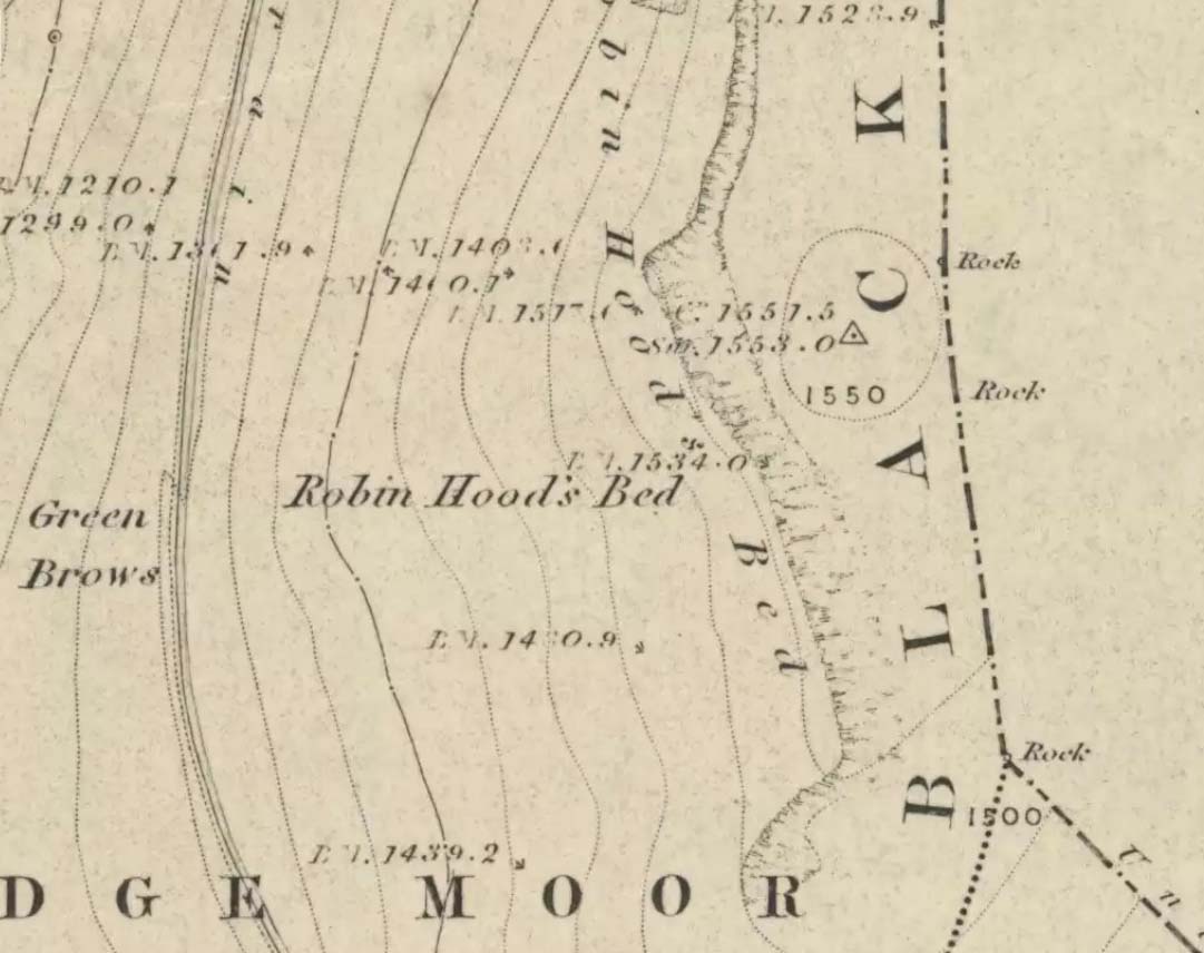
Follow the same directions to get to the Aiggin Stone. Once here, go over the stile by the fence opposite towards the great geological ridge less than half-a-mile south. Head for the triangulation pillar right on the top of the ridge, and there, about 20 yards past it, higher-up than the triangulation pillar at the very top of Blackstone Edge, is Robin Hood’s legendary stone bed!
Archaeology & History
Robin Hoods Bed, looking north
There’s very little of archaeological interest known up here, save a mass of flints and scrapers that have been found scattering the moorland heights hereby, from the mesolithic period onwards. But we have a relative lack of neolithic to Iron Age remains — officially anyhow! A possible standing stone can be found a few hundred yards south, but there’s little else.
The rock that’s given its name to Robin Hood’s Bed overlooks the very edge of the ridge, detached from the main section, with a large and very curious nature-worn ‘bed’ on its very crown, more than 4 feet wide and about 7 feet long, into which one comfortably lays. It was named in the boundary records of the township of Rishworth in 1836, where it describes other historical stones, saying:
“thence under Robin Hood’s Bed to a stone marked ‘W.S.G.S. 1742, 1770, 1792, and the following figures and letters, ‘1826 I.L.S.'”
Folklore
This enormous millstone grit boulder, sitting 1550 feet upon the high moors is, according to legend, a place where our famous legendary outlaw once slept. Whilst sleeping here, some of his followers were said to have kept guard and looked over him.
Robin Hood’s Bed, from below
A rather odd piece of folklore recited by Jessica Lofthouse (1976) is that “no winds ever blow” at Robin Hood’s Bed, who then went on to tell of the time she visited the place. Walking along the rocky ridge where the stone bed is found, the winds were such that “we had almost been blown over the edge,” until just a few hundred yards further when they eventually reached the fabled site, Nature granted them a sudden calmness unknown to all the high moorlands around, affirming the curious folklore.
The ceremonial stone ‘bed’
Robin Hood’s Bed itself was undeniably an important ceremonial site for both rites of passage and ritual magick to our indigenous ancestors. The place screams of it! It also seems very likely that the hero figure of Robin Hood replaced an earlier mythological character, akin to the fabled female creation deity, the cailleach, found commonly in more northern and Irish climes, whose echoes can still be found around our Pennine hills. For we find that Robin Hood was said to have taken a large boulder from here and with a mighty heave threw it six miles across the landscape due west into the setting sun, where it eventually landed at Monstone Edge, near Rochdale! Local people were so astounded at this feat that the stone was given the name of Robin Hood’s Quoit.
7ft tall natural standing stone
The old place-name authority Eilert Ekwall (1922) related the folklore that the giant ridge of Blackstone Edge “is said to refer to a boundary stone between Yorkshire and Lancashire.” Which may be the curious upright standing stone, more than 7 feet tall, less than 50 yards NNE which gives a very distinct impression of having been deliberately stood upright, amidst this mass of loose geological droppings! It would be helpful if there was a geologist in the house who could tell us decisively one way or the other…
Another etymological possibility that has been posited relates to the word ‘bed’ at this site. Ordinarily it would be sensible to attach the word to the great stone ‘bed’ atop of the poised boulder. But with the attached legends symptomatic of prehistoric monuments, it would not be improper to highlight that the old Welsh word ‘bedd‘ (a place-name element that is not uncommon in Lancashire) means, “a grave or tomb”. And this site would be ideal for such an old prehistoric cairn…
References:
Bennett, Paul, The Old Stones of Elmet, Capall Bann: Milverton 2001.
Ekwall, E., The Place-Names of Lancashire, Manchester University Press 1922.
Lofthouse, Jessica, North Country Folklore, Hale: London 1976.
Smith, A.H., The Place-Names of the West Riding of Yorkshire – volume 3, Cambridge University Press 1961.


")
")