This supposedly 10-12th century carving — found in the early 1940s and handed to the Scottish National Museum in Edinburgh by Mr A. Sanderson — took my interest by virtue of the distinct swastika design carved on the face of the stone.* The fact that it’s etched onto what’s thought to be the remains of an old christian cross shouldn’t be too surprising: we find it on numerous other old stone crosses, church bells and other religious remains.
This example was only carved on one side of the stone, which measures some 18-inches high and just 9 inches across. The top of the stone has a design typical of many early crosses from between the 9th to 14th century; whilst the curvaceous line on the lower-right also typifies imagery found on many crosses from this period — some of which appear to be based on cup-and-ring imagery. However, no such cup-and-rings seem to have been in evidence where this cross-remain was found. Very little else is known about its history.
Although it aint quite as old as Ilkley’s Swastika Stone, this is still a fascinating carved stone indeed!
References:
Royal Commission on the Ancient & Historical Monuments of Scotland, Peeblesshire – volume 1, HMSO: Edinburgh 1967.
Stevenson, Robert B.K., ‘The Inchyra Stone and some other Unpublished Early Christian Monuments’, in PSAS 92, 1961.
* To those who don’t know, the swastika symbol has been used by people from around 20,000 BC onwards and has only very recently gained a bad press. It’s a symbol that needs to be reclaimed, through education, and put back into its proper mythic place where it belongs – away from any Nazi dip-shits, whose retarded actions pale into insignificance when it comes to the primal archaic nature of this old form.
The grid reference here is an approximation, but the old well was definitely somewhere very close by, as evidenced by the place-name of the farmhouse. But if you wanna get here and wander about in the hope that you can re-locate this once sacred water source, go up the B1269 road north of Guisborough for about a mile. Carling Howe farmhouse is on the left-hand side of the road. Obviously the old well is somewhere close by…
Archaeology & History
The information I have of this site comes from old place-name listings. I found the reference in the directory for North Yorkshire by A.H. Smith (1928), in his entry for the etymology of ‘Carling Howe’ at Guisborough. Smith ascribes the references of ‘Kerlinghou’ (which itself appears to have been lost) to mean the ‘Old woman’s mound’ and variants thereof, also saying, “There is an unidentified place in this township called Kerlingkelde,” (12th century ref. Guisborough Cartulary)—the ‘Old Woman’s Well’. Very commonly in this part of Yorkshire—as at many other locations in northern England—a hou or howe (and variants thereof) relates to a prehistoric tomb – which is probably what we had here: a prehistoric Old Woman’s Grave with an associated Old Woman’s Well in close attendance.
The ‘old woman’ element in this name very probably relates to that primal mythic deity, the cailleach, the great prima mater of indigenous heathen folk, beloved mainly in Scottish and Irish lore, where her copious name and tales resonate to this day. This “well of the Old Woman, or cailleach“, would have been a place of particular importance in the mythic cosmology of our ancestors, but its precise whereabouts seems forgotten. There is a plentiful supply of water around Carling Howe Farm, one or more of which may once have been the site of this well. However, a lot of quarrying operations occurred here in the not-too-distant past, and this may have irreparably damaged our ability to accurately find the site – though perhaps a perusal of old field-maps could be productive.
It would also be good if we could locate the original whereabouts of the old tomb here which gave the place its name – the ‘Carling Howe’. Other ‘howe’ sites in East and North Yorkshire turn out to be prehistoric burials and I have little doubt that the same occurred here.
References:
o’ Crualaoich, Gearoid, The Book of the Cailleach, Cork University Press 2003.
Smith, A.H., The Place-Names of the North Riding of Yorkshire, Cambridge University Press 1928.
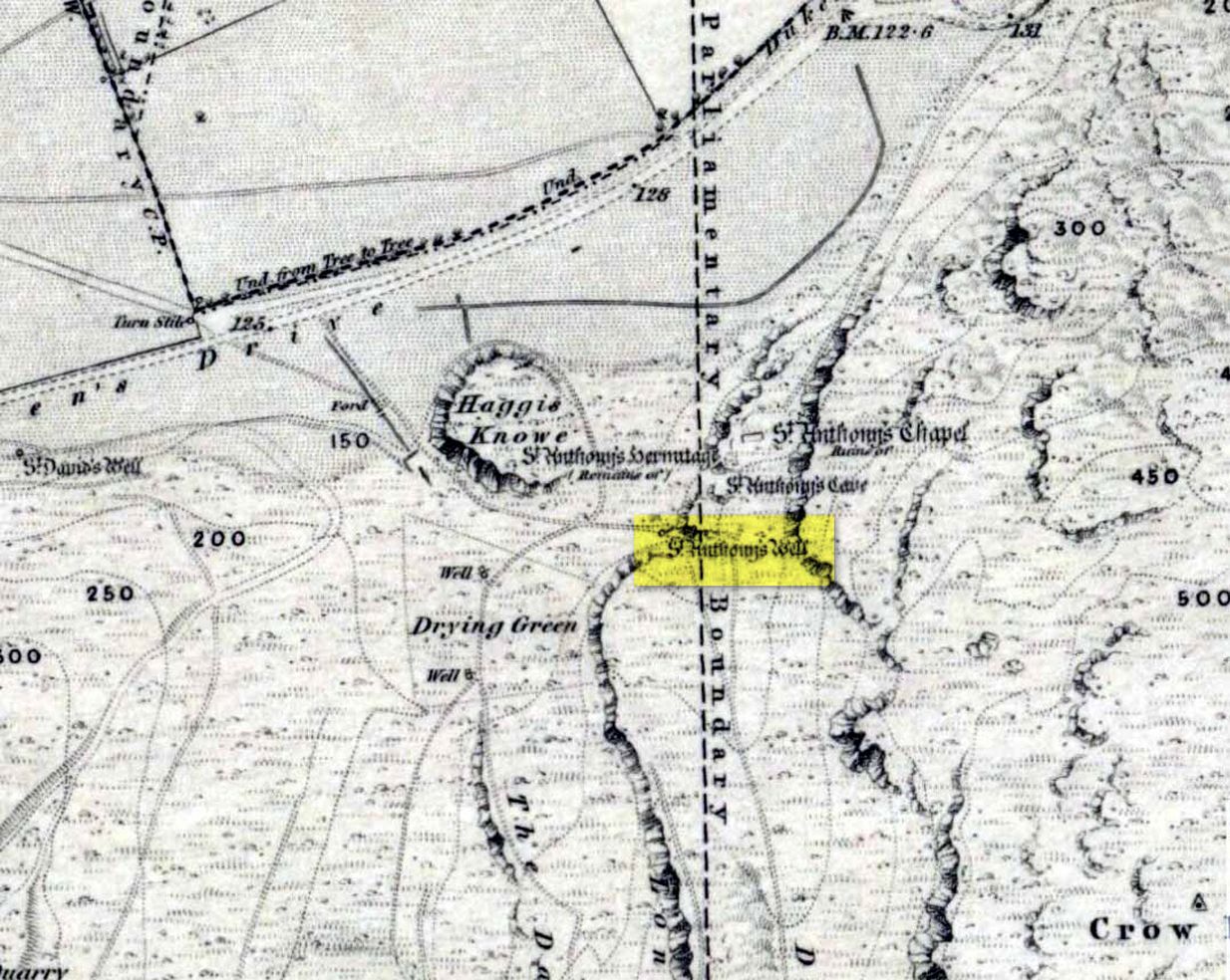
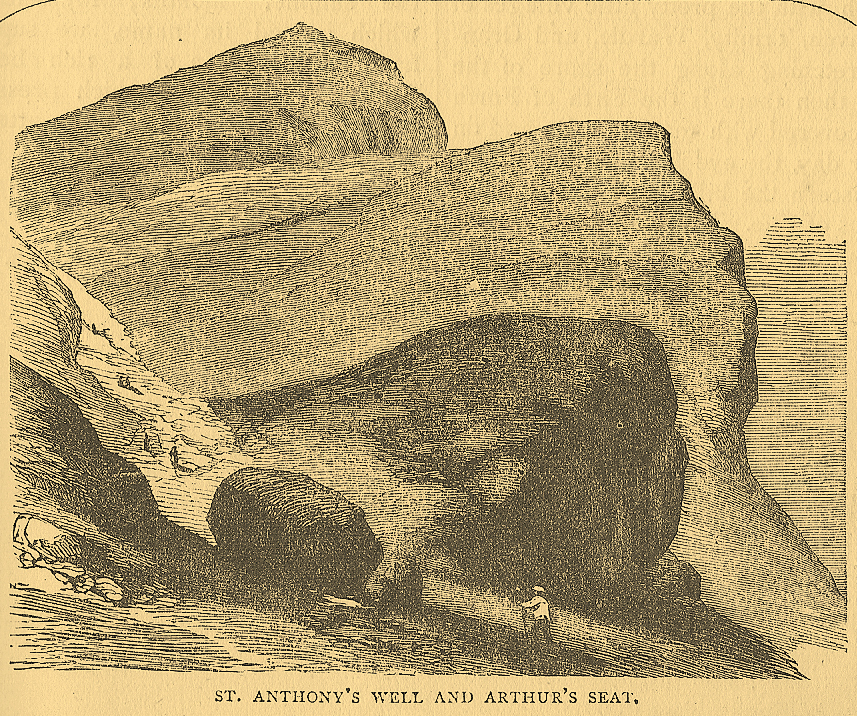
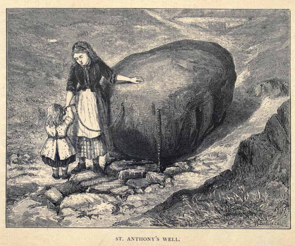
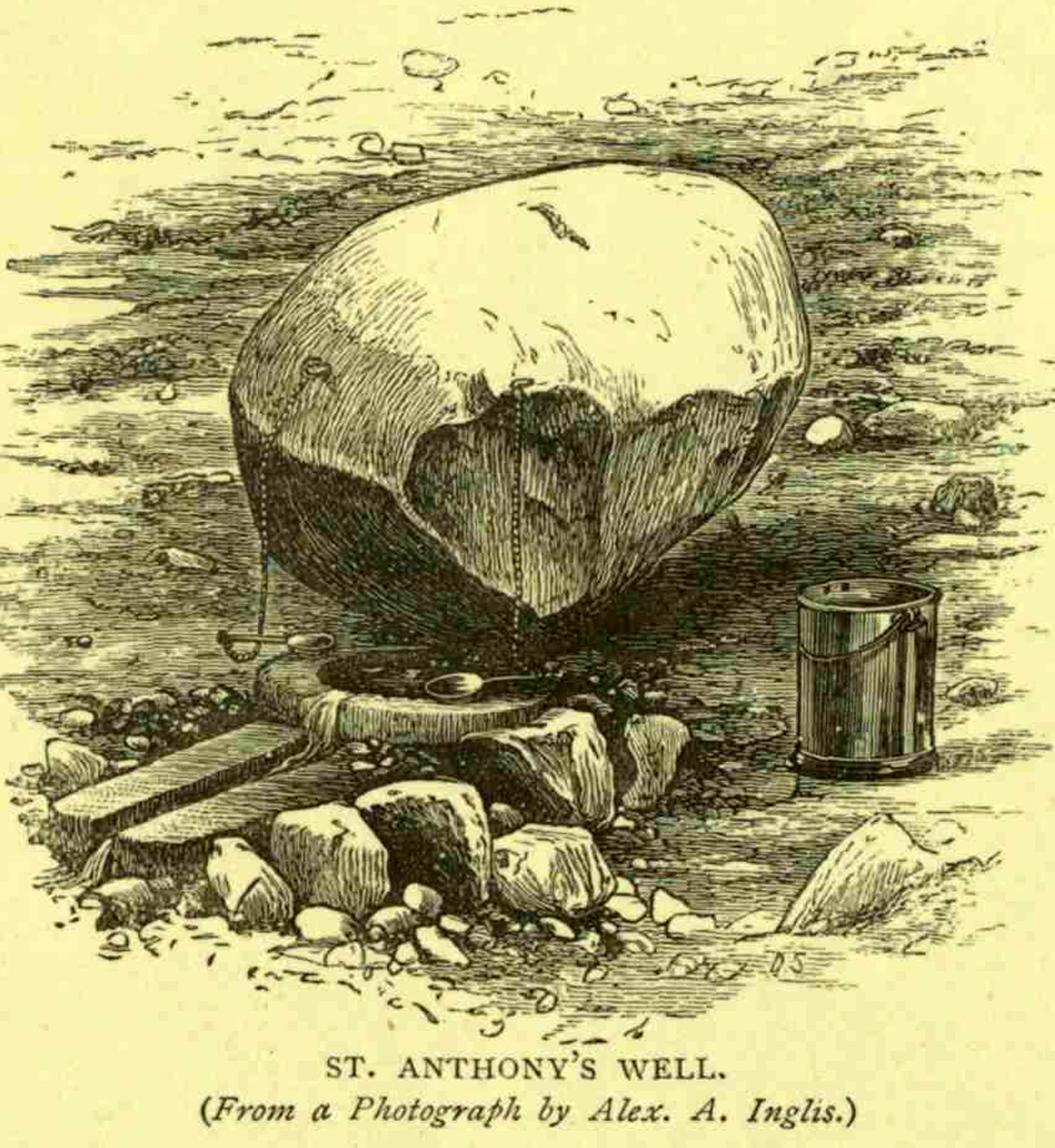
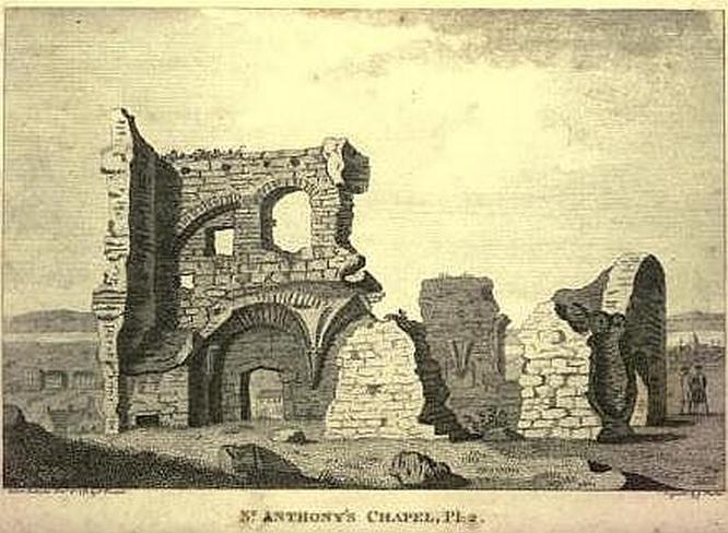
Not too difficult to find really. Get to the northern part of the road which encircles Arthur’s Seat and when you get to St. Margaret’s Loch (near St. Margaret’s Well), look up the slopes on your right where you see the remains of St. Anthony’s Chapel. You need to head up the footpath here until you reach a large-ish ovoid boulder, with a small circular trough into which the waters run (the drawing of the place here, with the rock in the lower-left, just in front of the fella walking towards it, is just right!). You’re here!
Archaeology & History
St Anthony’s Well, Arthurs Seat
Tradition tells that the remains of St. Anthony’s Chapel was built on the northern ridge by Arthur’s Seat, “mainly for guardianship of the holy well named after the saint” — which sounds rather like the christianization story of a heathen site. Francis Grose (1797) told that “this situation was undoubtedly chosen with an intention of attracting the notice of seamen coming up that Frith; who, in cases of danger, might be induced to make vows to its tutelar saint.” If this was the case, it sounds even more like a site that had prior heathen associations. Grose also told us that just a short distance from the chapel, were the remains of an old hermitage:
“It was partly of masonry worked upon the natural rock. At the east end there are still two niches remaining; in one of which formerly stood a skull, a book, an hour-glass, and a lamp, which, with a mat for a bed, made the general furniture of the hermitage.”
I like the sound of the place! Just up my street! Little other archaeological info has emerged from this tiny spot — but the healing waters of the well would obviously have been of importance to our indigenous inhabitants (anyone who wants to think otherwise is simply a bit dim!) as there is a wealth of archaeological sites and relics all round Arthur’s Seat.
Folklore
A number of writers have described this old well, which has sun-lore, healing properties, and Beltane rites surrounding its past. Local people of all social classes frequented this ancient spring, particularly on that most favoured of heathen days, Beltane. The site was of considerable mythic importance with a certain order about it. As Hone (1839) said:
“…the poorer classes in Edinburgh poured forth at daybreak from street and lane to assemble on Arthur’s Seat to see the sun rise on May-morning. Bagpipes and other musical intruments enlivened the scene, nor were refreshments forgotten. About six o’ clock a crowd of citizens of the wealthier class made their appearance, while the majority of the first-comers returned to the town. At nine o’ clock the hill was practically deserted.”
Another early account describing St. Anthony’s Well is from an article in the great PSAS journal of 1883. Here, J.R. Walker wrote:
St Anthonys Well
To an incident which showed that the faith and belief in the healing virtues of the wells is still strong, the writer was but a few months ago an eye-witness. While walking in the Queen’s Park about sunset, I casually passed St. Anthony’s Well, and had my attention attracted by the number of people about it, all simply quenching their thirst, some possibly with a dim idea that they would reap some benefit from the draught. Standing a little apart, however, and evidently patiently waiting a favourable moment to present itself for their purpose, was a group of four. Feeling somewhat curious as to their intention, I quietly kept myself in the back ground, and by and by was rewarded. The crowd departed, and the group came forward, consisting of two old women, a younger woman of about thirty, and a pale, sickly-looking girl — a child of three or four years old. Producing cups from their pockets, the old women dipped them in the pool, filled them, and drank the contents. A full cup was then presented to the younger woman, and another to the child. Then one of the old women produced a long linen bandage, dipped it in the water, wrung it, dipped it in again, and then wound it round the child’s head, covering the eyes, the youngest woman, evidently the mother of the child, carefully observing the operation, and weeping gently all the time. The other old woman not engaged in this work was carefully filling a clear flat glass bottle with the water, evidently for future use. Then, after the principal operators had looked at each other with an earnest and half solemn sort of look, the party wended its way carefully down the hill
Earlier still we find more lore of the place in Wilson’s Edinburgh [1848] where he told:
St Anthony’s Chapel 1785
“The ancient Hermitage and Chapel of St. Anthony, underneath the hangings of Arthur’s Seat, are velieved to have formed a dependency of the preceptory at Leith, and to have been placed there, to catch the seaman’s eyes as he entered the Firth, or departed on some long and perilous voyage; when his voews and offerings would be most freely made to the patron saint, and the hermit who ministered at his altar. No record, however, now remains to add to the tradition of its dedication to St. Anthony; but the silver stream, celebrated in the plaintive old song, ‘O waly, waly, up yon bank,’ still wells clearly forth at the foot of the rock, filling the little basin of St. Anthony’s Well, and rippling pleasantly through the long grass into the lower valley.”
Votive offerings made here eventually turned the waters into a simply wishing well for incomers, even in Victorian times (oh how the locals must have hated such trangression…). The great Scottish holy wells writer J.M. MacKinlay (1893) told in his day the tale of,
“a little girl from Aberdeenshire, when on a visit to Edinburgh, made trial of the sacred spring. She was cautioned not to tell anyone what her wish was, else the charm would have no effect. On her return home however, her eagerness to know whether the wish had…been fulfilled, quite overcame her ability to keep the secret. Her first words were, ‘Has the pony come?’ St. Anthony must have been in good humour with the child, for he provided the pony, thus evidently condoning the breach of silence in deference to her youth.”
In the middle of the 20th century, the great folklorist F.M. MacNeill (1959) wrote:
“Even in Edinburgh, little bands of the faithful may be seen making their way through the King’s Park to Arthur’s Seat, and, as in the eighteenth century:
On May-Day, in a fairy ring,
We’ve seen them round St. Anton’s spring,
Frae grass the caller dew-drops wring,
To weet their een,
And water clear as crystal spring,
To synd them clean.”
And when Ruth and Frank Morris (1982) got round to their excellent survey, they found that this old well was still being used “by youths and maidens, who come to wash their faces with the dew on May Day mornings, a wish at St. Anthony’s being a part of the ritual.” But this final remark may have the simple prosaic coincidence of them observing people like I, when younger, who frolicked with girlfriends around May morning, in the grasses near the old well — though at the time I knew nothing about the old sacred waters on the slopes just above us!
Pretty easy to get to. Best thing to do really, is ask a local and they’ll send you in the right direction. From Bingley, take the Harden road (B6429) across the river. As it bends sharply left, note there’s a track going up into the woods to the right. Walk up it! Keep going and, unless you take a detour, you’ll end up at the rock outcrop eventually (where the woods come to an end, Druid’s Altar appears before you with the track running along its top-side).
Archaeology & History
Mentioned in the Tithe Awards of 1849, this lovely outcrop of rocks looking down the Aire Valley on the southern edge of Bingley has “an immemorial tradition” of druidic worship, said Harry Speight in 1898 – though quite when it first acquired such repute is outside of any literary record. In Sidney Greenbank’s (1929) rare book on this place, he could find little by way of archaeological data to affirm the old tradition, save the odd prehistoric find of flints here and there; though it is said that Beltane fires were burned upon the crags here in bygone centuries.
1894 photo of Druid’s Altar (courtesy Clive Hardy)
There was a 19th century account from the Ilkley Scientific Club where a member described there being a cup-and-ring carving “near the so-called Druid’s Altar, at Bingley,” but I’m unaware of the whereabouts of this carving and Boughey & Vickerman’s (2003) said nothing about it in their survey; though a possible cup-marking can be seen on one rock less than 100 yards west, which might account for the report. (a bit dodgy though!)
Folklore
Harry Speight (1898) makes what sounds like a rare flight of fancy when he described faerie being seen atop of the many oaks beneath the Druid’s Altar. In Clive Hardy’s (2002) work (from whence the old photo of the Altar is taken), he tells how “local antiquarians say that the cobbled way running from the Brown Cow Inn towards the site, is an old processional route walked by the druids.”
One, possibly two wells, each beneath the Altar rocks, are also reputed to have been associated with the old pagan priests, as their names tell: the Altar Well and the Druid’s Well – though the Altar Well has seemingly fallen back to Earth in recent years.
References:
Greenbank, Sidney, The Druid’s Altar, Bingley, R.G. Preston: Bingley 1929.
Hardy, Clive, Around Bradford, Frith Book Ltd: Salisbury 2002.
Although the lads at the Scottish Royal Commission (1974) initially described this site as a ‘Standing Stone’, it is in fact,
“an erratic boulder of granite roughly shaped in the form of a cross… It measures 0.8m in height, 0.6m in width at base, and 0.4m in width at the top…(and) the stone is supposed to have marked a boundary.”
The site was evidently of some mythic importance, as the great Cathedral of St. Moluag was built next to the stone — unless the giant cairn of Cnoc Aingil, 500 yards away, was to blame. A holy well of this saint’s name (an obvious heathen site beforehand) is also nearby.
Folklore
Although this stone was dedicated to swans, I’ve not found the story behind the name. There were no buried swans here, but local tradition told that this old boulder could give sanctuary to anyone who touched it, or ran round it sunwise. The Hebridean folklorist Otta Swire (1964) told that,
“anyone who claimed such sanctuary had his case considered by ‘the Elders.’ If they considered his plea justified, they ‘came out and walked sun-wise round the Swan Stone.’ If they did not approve of his right to sanctuary, they walked round it anti-clockwise and the man was then given over, not to his enemies, but ‘to Authority’ to be tried.”
This old tradition derives from well known pre-christian rites. Swire also reported that even in the 1960s here, “at funerals the coffin is always carried round the grave sun-wise before being laid in it.” An old cross placed in the Field of the Cross next to the stone was an attempt to tease folk away from heathen rites of the stone, but failed.
References:
Royal Commission on the Ancient & Historical Monuments of Scotland, Argyll – volume 2: Lorn, RCAHMS: Edinburgh 1974.
Swire, O.F., The Inner Hebrides and their Legends, Collins: London 1964.
From Otley go north straight over the river and upwards into the countryside for nearly two miles (past the TV mast on the right). As you reach near the top of the hill, there’s a turn to your right. Go on here for a hundred yards or so, then walk along the footpath to your right. After a few hundred yards, keep your eyes out for the stone just through the gate, in the walling on your left.
Archaeology & History
Although we see named on the 1853 Ordnance Survey map the respective place-names of Bride Cross House and Bride Cross Allotment, the first literary reference to any site here as a standing stone appears to be Eric Cowling (1946) who, when commenting on the pagan tradition and folklore of ancient sites, told that
“The name of Bride Cross Farm, Dob Park, is very significant, for at the meeting place of several tracks to the south-east is a squat standing stone built into a wall and marked as a boundary stone, which was probably Brides Cross.”
Bride Stone, Farnley MoorBoundary markers on top
Although I’d read about this place as a kid, it was Graeme Chappell who first brought me here some twenty years back, in one of our many exploratory forays into the prehistory of this area. It’s a nice fat squat standing stone, similar in stature to the more famous Bull Stone near Otley Chevin, a few miles to the south — though our Bride Stone here is about half as high. Only about three-feet tall, it stands by the gate at the wall-side about 200 yards down the footpath from the Dob Park Lodge road and does seems to have been used as a boundary marker, as the letters “F.F.” are carved deeply on top of the upright (possibly denoting the Fawkes family of Farnley).
Cowling’s assertion that this old stone accounts for the ‘Bride Cross’ place-name is probably right, as the site is roughly midway between the respective place-names of the House and Allotment. There is an old field-name of Crosse Close in the vicinity, from 1692, but I haven’t located it. If such a cross ever existed nearby (most likely, it’s gotta be said), it’s obviously the relic which left the place-names — though the standing stone was certainly here first! As yet, we’ve found no references to this place before 1853…which can’t be right…
Folklore
Seems to be a petrification legend in here somewhere. Although the short tale doesn’t say as much, it is supposed to have got its name through “the murder of a bride, rejected by a suitor, on her return from a wedding.” Indeed, I’d go so far as to say ‘fertility’ as well!
Eric Cowling (1946) really stuck his neck out and reckoned sacrifices occurred here in the not too distant past. This may relate to the nearby Haddock Stones, a few hundred yards south, thought to derive its name from a cairn and ‘altar stones.’
References:
Bennett, Paul, The Old Stones of Elmet, Capall Bann: Milverton 2001.
Cowling, E.T., Rombald’s Way, William Walker: Otley 1946.
Phillips, Guy Ragland, Brigantia — A Mysteriography, RKP: London 1976.
Smith, A.H., The Place-Names of the West Riding of Yorkshire – volume 5, Cambridge University Press 1961.
Start at the Nick of Pendle and walk up the footpath towards the denuded Apronful of Stones’ cairn. Keep going up the hill for another 300 yards or so, just past where there’s a path that turns-off towards the ritual Deer Stones. As you walk upwards, in front of you you’ll see the tell-tale sign of many small stones scattered in their tell-tale manner, rising up at the edge of the footpath. This is it!
Archaeology & History
This was the third in a group of previously unrecognized giant cairns that I found in August 2006 (it certainly wasn’t in the archaeology records anyway), all on the south side of our legendary Pendle Hill — and it’s bloody huge! However, unlike the other two (the Devil’s Apronful and the Lower Apronful of Stones, further down the slopes), this one doesn’t seem as certain as the other two, but it’s still worth including here and cannot be discounted until a decent archaeological assessment has been made.
Looking up to the height of the Badger Wells CairnSection of the surface remains, showing thousands of stones
Just like its companion cairns, although it’s covered over with much soil and grasses, all round the edges are hundreds of small stones and rocks, of the same type and size as the other two a bit further down the hill, and similar to the Skirtful of Stones on Ilkley and elsewhere. The overgrown heap of stones here stands about ten-feet tall from the lower western edge and measures approximately 28 yards (north-south) by 20 yards (east-west).
Although this cairn is named after the nearby Badger Wells — which gets its name either from the local badger population, or else the old ‘badger-men’ who used to trade hereby — another fresh water source also emerges near the bottom of its western side.
Upon asking a couple of passers-by (they were local regular walkers up this great hill) about this and the other giant overgrown cairns upon this hill, they didn’t have a clue they existed — although they did suggest we contact the Lord of Downham on the north side of the hill. And so there we ventured, in search of the Great Stone – and guess who we bumped into…?
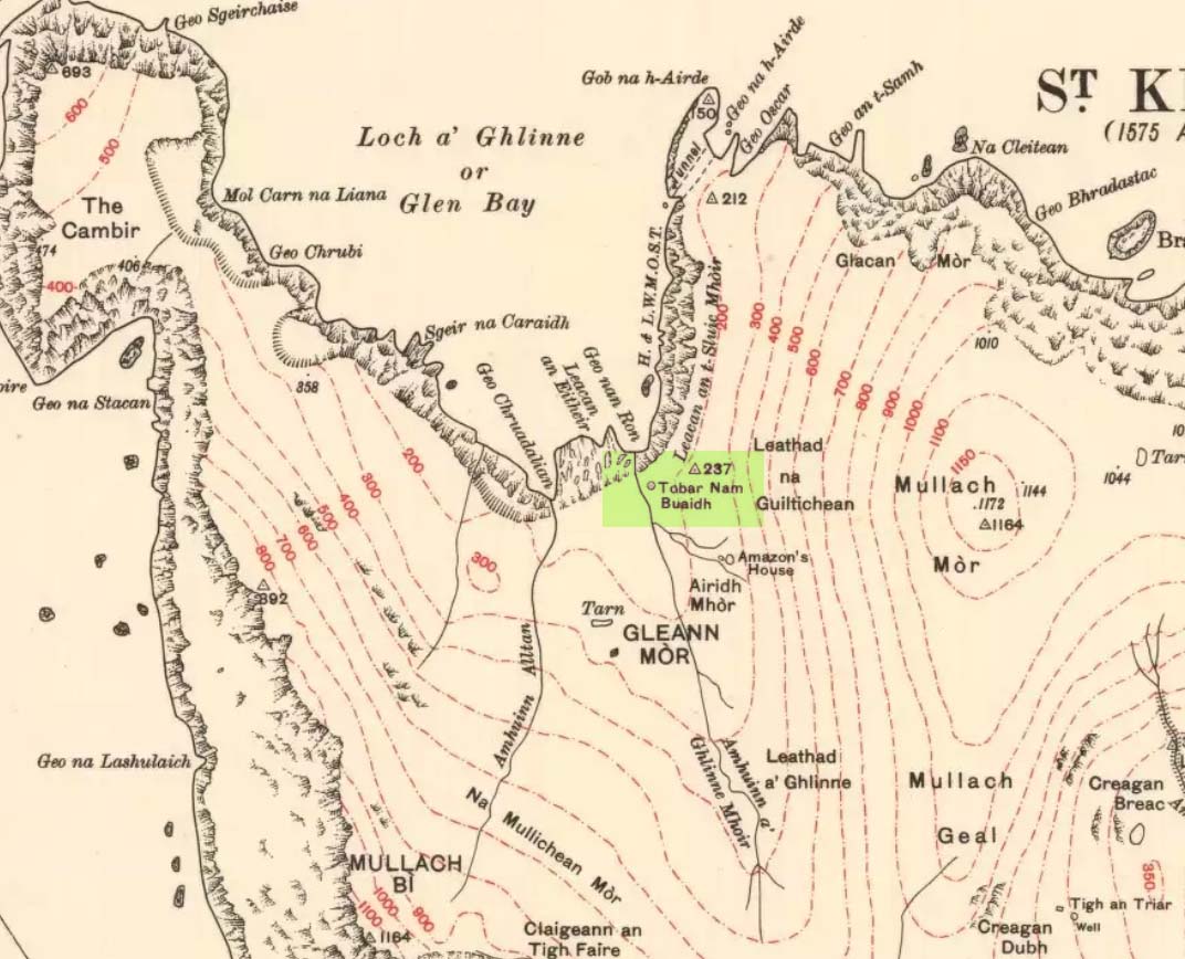
This legendary healing spring (the Well of Virtues) is on the north side of the island, a few hundred yards northwest of the legendary Amazon’s House. Martin Martin (1703) told that this well,
“near the female warrior’s house is reputed to be the best, the name Toubir-nim-buey, importing no less than the well of qualities or virtues; it runneth from east to west, being sixty paces ascent above sea; I drank of it twice, and English quart at each time; it is very clear, exceeding cold, light and diuretick; I was not able to hold my hands in it above a few minutes, in regard of its coldness; the inhabitants of Harries find it effectual against windy-chollicks, gravel, head-aches; this well hath a cover of stone.”
The reverend Kenneth Macaulay (1764) also wrote of this place, giving additional details:
“Near the fountain stood an altar on which the distressed votaries laid down their oblations. Before they could touch the sacred water with any prospect of success, it was their constant practice to address the genius of the place with supplication and prayer. No one approached him with empty hands. But the devotees were abundantly frugal. The offerings presented by them were the poorest acknowledgements that could be made to a superior being, from whom they had either hopes or fears. Shells and pebbles, rags of linen, or stuffs worn out, pins, needles or rusty nails, were generally all the tribute that was paid; and sometimes, though rarely enough, copper coins of the smallest value.”
T.S. Muir’s sketch
There was a very small stone-built well-house with a low roof covering the top of the spring, inside which a small pool formed. The small well-house was described by Thomas Muir (1883) and ruins of it are reported to still cover the sacred waters, which run into an old stone trough. Muir called it the ‘spring of many virtues’, describing it as one of five holy wells on this small isle.
In James MacKinlay’s (1893) magnum opus he reported that its waters could cure deafness.
References:
Macaulay, Kenneth, The History of St. Kilda, James Thin: Edinburgh 1974 (original edition 1764).
MacKinlay, James, Folklore of Scottish Lochs and Springs, William Hodge: Glasgow 1893.
Martin, M., Description of the Western Isles of Scotland, Andrew Bell: London 1703.
Mathieson, J., “The Antiquities of the St. Kilda Group of Islands,”in Proceedings Society of the Antiquaries Scotland, volume 62, 1928.
Muir, Thomas S., Ecclesiological Notes on some of the Islands of Scotland, David Douglas: Edinburgh 1883.
This legendary-sounding spring of water was described in field-name listings from the 1770 Enclosure Acts, but nothing seems to have been written about it since. To me at least, there seems little doubt that this site would have been a sacred or legendary water-site. Curiously it is in William Henderson’s collection of northern folk-tales where we find a mention of further dragon lore from the township, albeit briefly, where he wrote:
“Near Chipping Norton, in Oxfordshire, A.D. 1349, was a serpent with two heads, faces like women, and great wings after the manner of a bat.”
In Nigel Pennick’s (1997) overview of dragon legends he copied Henderson’s earlier note, but neither of them gave specific indications relating the legend with our Serpent’s Well. So, to those of you who live in and around Chipping Norton (where I spent two very good years living with Sir Wilson at the Rollright Stones) – what has become of it? Where exactly is it? And does anyone know anything more behind this tale and any further history behind the ‘Serpent’s Well’?
References:
Gelling, Margaret, The Place-Names of Oxfordshire, Cambridge University Press 1953-54.
Henderson, William, Notes on the Folk-lore of the Northern Counties of England and the Borders, Folklore Society: London 1879.
Pennick, Nigel, Dragons of the West, Capall Bann: Chieveley 1997.
We were up here again in July 2009, but I’ve still not been across onto the island itself — just stared from the lochside, dying to swim across and spend a night or three alone on the island amidst this legendary landscape. Basically, get to Talladale on the A832 (halfway between Gairloch and Kinlochewe), then walk up to the loch-side to your right (east) for a mile till you reach the small wooded outcrop. Look north, betwixt the two isles and its the one in the middle with the Crag of the Bull and Maire’s Cairn rising up the mountain face behind. But you can reach it via a boat trip from one of the local harbours. Staying there overnight however, would seem more troublesome. It seems that a winter visit seems best!
Folklore
This ‘holy well’ has a prodigious occult history which, sez my nose, is still maintained by one or two old Highland folk up here. This small island (one of many in this long loch) was the Isle of the Druids in old days: legend telling it to be the teaching ground of these shady priests. Even the Iona druids came here. The main relics on on the island are the old holy well, accompanied by an old legendary tree into which all local people flocked and wedged coins at least once in their life. This devotional rite eventually took its toll, with so many of the coins covering the old tree with metallic scales to a height of nine feet, eventually killing it.
The well itself was said to cure insanity — no doubt the remedial quality given to the waters after neophyte druids had spent many days of ritual solitude here, eventually sipping its life-giving fluid to revive them from their ordeal.
It eventually became sanctified by the Church: legend saying it was St. Maelrubha (the same dood who turned the healthy Applecross heathens into church-goers) who was the guilty party. Indeed, the name Maree itself, was proclaimed as deriving from this old saint, though local lore tells it to derive from the pagan ‘ane god Mourie.’
Elizabeth Sutherland (1985) reported that remains of the sacred tree were still visible. It is also said that no-one makes ritual commemmoration here anymore. Hmmmm… don’t always believe what you read.
In the 18th century, when Thomas Pennant visited this sacred well, he described that,
“in the midst is a circular dike of stones… I expect the dike to have originally been druidical, and that the ancient superstition of paganism had been taken up by the saint (Maelrubha) as the readiest method of making a conquest over the minds of the inhabitants.”
References:
Dixon, John, Gairloch in North-west Ross-Shire, Co-op: Edinburgh 1886.
MacKenzie, Kenneth C., Loch Maree: The Jewel in the Crown, privately printed 2002.
MacKinlay, James M., Folklore of Scottish Lochs and Springs, William Hodge: Glasgow 1893.
Pennant, Thomas, A Tour in Scotland and Voyage to the Hebrides, MDCCLXXII, John Monk: Chester 1774.
Polson, Alexander, Gairloch, George Souter: Dingwall 1920.
Sutherland, Elizabeth, Ravens and Black Rain, Constable: London 1985.
Watson, W.J., Place-Names of Ross and Cromarty, Northern Counties Printing: Inverness 1904.
* This beautiful painting is one of many done by local artist, Bryan Islip. It is taken from his 2010 Calendar, Scotland’s Wester Ross, and is available direct from him. If you’d like to know more, or want copies of his calendar or other artworks, email him at: pico555@btopenworld.com – or check his website at www.picturesandpoems.co.uk