This is the first detailed guide ever written on the holy wells and healing springs in and around the ancient city of Edinburgh, Scotland. Written in a simple A-Z gazetteer style, nearly 70 individual sites are described, each with their grid-reference location, history, folklore and medicinal properties where known. Although a number them have long since fallen prey to the expanse of Industrialism, many sites can still be visited by the modern historian, pilgrim, christian, pagan or tourist.
The book opens with two introductory chapters: the first explores the origin and nature of holy wells and what they meant to local people in earlier centuries; and the next is a comparative overview of water cults worldwide. It is an invaluable guide for any student or tourist who wants to look beneath the modern history of the city and get a taste of the more archaic customs that once belonged here…
The stone circle of Fingal’s Cauldron Seat, Machrie Moor, Arran (photo by Aisha Domleo)
By whichever way you come (be it from Brodick on the east, Lochranza to the north) ask any local the way to Machrie and they’ll point you the road onto the west side of the island, roughly halfway. You’re after the hamlets of Blackwaterfoot or Auchagallon. From either of these spots, take the road to Tormore. From here, the dirt-track east close to the Machrie Water is where you need to walk. About a mile along this well-defined track you’ll see the large barn ahead of you. Hereabouts you’ll begin to notice some very tall standing stones. Keep walking on the track, and the first double-ring of smaller stones to your right is the place yer after!
Archaeology & History
Approaching the ring (photo by Aisha Domleo)
This is one well-preserved stone circle in a superb setting with other large megalithic rings all close by—at least 12 of them!—set upon the flat open moorlands on the west side of Arran, with views in all directions sending the enquiring nose tasting for more wherever the eyes gaze…. It has been written about by many many writers over the last few centuries—which aint surprising! But it was in recent times that the place was said by Aubrey Burl (1981) to be “holy ground,” because although there are many prehistoric settlement sites and other remains scattered across this landscape,
“it is noticeable that the dozens of huts whose ruins litter the moor were built well away to the west, none of them near these powerful and lonely stones.”
1832 sketch of Fingal’s Cauldron by James Skene
It’s a fair point.
Fingal’s Cauldron was first defined in an archaeological context by James Bryce in 1863, who named it the ‘Machrie Moor 5’ stone circle (MM5)—and it was he and several others who dug into the ring, to see what it might be hiding!
“Excavating at the centre we found a small cist at less than a foot in depth, and lying about north-east. It was covered by a small lid, and the dimensions were 2 feet 2 inches in length, 10½ inches in depth, and 11 inches in width. Inside there were several bone fragments and black earth. A flint implement was found in the stony soil above, and three other flint fragments, but nothing of this kind in the cist itself. This was of much ruder structure than any we had seen before (Ed. – i.e., in the other Machrie circles); it was cut out of the sold sandstone rock, but with little care or exactness; the sides however, were nearly perpendicular. The difficulty of excavating without iron tools may account for the smaller size and ruder form of this cist. No other cist was found, nor remains of any kind, though a trial was made at several points around the centre. A deep opening was also made on both sides of the upright stone, but nothing was met with worthy of being recorded.”
A.E. Roy’s 1967 site-plan
Described thereafter a number of times by different historians and antiquarians, Fingal’s Cauldron (and its associates) was then recounted in the Machrie Moor survey of Mr Balfour (1910) in his magnum opus on the Isle of Arran. Although he gave more attention to the other stone circles in this multiple megalithic complex, he did thankfully make note that,
“upon higher ground free of peat, and immediately to the south of the farmhouse, is the celebrated double circle of granite blocks known popularly as Fingal’s Cauldron Seat. The inner ring consists of eight and the outer of fourteen blocks. The diameter of the inner circle is 36 feet and of the outer 57 feet. The largest stones are in the inner series; they are more or less round-topped blocks, about 4 feet high. One of the stones of the outer ring has a ledge which is perforated by a round hole, with the edges worn smooth.
“In the centre of the inner ring, only a foot from the surface, a ruined cist was laid bare. It had been previously disturbed, and was represented by two stones only, lying parallel to one another. There was no capstone, and no relics were discovered.”
More recently in the 1960s, another survey of Fingal’s Cauldron was undertaken by A.E. Roy and other archaeologists. They found nothing new of any value, but gave us the ground-plan we see here (sadly it seems that Alexander Thom didn’t bless this site with his theodolite and survey). Aubrey Burl re-examined the site again during his own survey in the 1980s.
An elemental called Lara sat seated on one of the uprights! (photo by Aisha Domleo)Small section of inner & outer rings (photo by Aisha Domleo)
There are other curious features to this ring that aint generally talked about amongst the archaeo-fraternity, out of fear of sounding inspiring perhaps… In the 1980s, a chap called Paul Devereux and a number of physicists organized volunteers from across the country to monitor electromagnetic anomalies at many megalithic rings, in order to explore the validity, or otherwise, of the idea that there were ‘energies’ at stone circles. The study was called The Dragon Project and went on for many years. The Machrie Moor complex was one of the places where examinations of electromagnetic fields were undertaken—Fingal’s Cauldron being one of them. Devereux (1990) tells us a small part of the story:
“In May 1983 Dave and Lynn Patrick monitored several of the Machrie Moor circles, including MM5, with a geiger counter for the Gaia Programme. They also took background control readings and monitored a non-megalithic ‘dummy site’ for comparisons.
“Five of the circles…gave average site readings 2 to 13 per cent higher than background, but MM5 gave a site average of 33 per cent above background. A non-megalithic ‘dummy site’ was 5 per cent above background. The Patricks had taken 20 readings within MM5—one hour of monitoring time—plotted onto the ground-plan. There was no mystery about why the site gave a higher average than anywhere else, and a third higher than background—the stones are radioactive granite, and there are 23 of them. But one stone, the tallest, and the most westerly of the upright stones in the inner ring, is particularly energetic, giving readings 16 per cent above the next most radioactive stone in the double ring, and more than that for the other 58 stones monitored in the Patrick’s study on Machrie Moor.
“I took measurements at the site myself in April 1988, using new equipment, and confirmed that the MM5 stone did indeed give a moderately high naturally radiation count (about 33 per cent above normal).”
This rather hot “Cauldron of Finn” certainly does throw off more heat than its compatriots nearby, as scientific analysis has shown! It turned out to be the type of stone which our ancestors used in constructing the site. Fascinating…
Folklore
1861 drawing of the site
Although this is one of the smallest of the megalithic rings on the moor, it’s the one that has the main legend. In line with its folk-title, twas said to have been the place where the Irish giant and hero-figure, Finn, “assigning to the encircling stones the purpose of supporting the cauldron of the giant,” with the inner ring being where it was placed and he cooked. Finn also used another part of the circle, as James Bryce (1863) said:
“A block on the southeast side of the outer circle has a ledge perforated by a round hole, which is well worn on the edges, and said to have been formed for the purpose of fastening the favourite dog Bran.”
Shortly after this, John McArthur (1873) wrote his work on the ancient remains of the island, giving additional elements to the myths of this ring; firstly telling that the perforated hole which Bran was tied to,
“was probably associated with some old superstition or religious ceremony, now forgotten. The hole is sufficiently large to admit the two fingers, and runs perpendicularly through the side of the column…
“The perforated column of “Fiongal’s Cauldron Seat,” on the Mauchrie Moor, was believed to contain a fairy or brownie, who could only be propitiated by the pouring of milk through the hole bored in the side of the stone.”
The animistic tradition of pouring milk into stones is more usually found at bullauns and some cup-and-ring carvings, so we need to look closely in good weather conditions at the uprights in the circle just to make sure we aint missed anything here… Carvings are found on some of the other Machrie stones.
Regarding the small hole through the stone which Bran was tied to, Gareth Weston (2007), in his otherwise terrible book, tells that,
“The middle of the perforated stone and the geometric centre (of the ring) are in line with the sharp summit of Goat Fell, Arran’s loftiest peak and the highest point in southeast Scotland.”
Geomancy anyone…?
Forteana
Over the years I have slept at many prehistoric sites in Britain—stone circles, chambered tombs and cup-and-ring stones all—hundreds of times, in all weathers. Sadly in recent years I’ve been neglecting this duty. However, during the winter of 1986 I spent a few nights in the snow on the Machrie plain, between this circle and the taller uprights a short distance away. On one dark freezing February night, shortly before we hit the sack,
“a bright orange glow was seen on the summit of the mountain (Ard Bheinn), three miles away. A second or two later a ball of light rose up from the snow-clad hills and into the clouds, a hundred feet above. A few minutes later we saw the same ball of light again; on both occasions the ball of light was visible for two seconds at the most.”
Several times when sleeping rough at Machrie I got talking with an old farmer who had grown up round here. He told that he’d “seen strange lights around the moors a few times” down the years. With the moorland scent and feel of the place round here, that surprises me not one bit!
McArthur, John, The Antiquities of Arran, Adam & Charles Black: Edinburgh 1873 (2nd edition).
MacLellan, Robert, The Ancient Monuments of Arran, HMSO: Edinburgh 1989.
Roy, A.E., “A New Survey of the Tormore Circles,” in Transactions of the Glasgow Archaeological Society, 51, 1963.
Weston, Garth, Monuments and Mountains, Ashridge Press: Bakewell 2007.
Acknowledgements: HUGE thanks to Aisha Domleo—and Her brilliant clan!—not only for kicking my arse to write this up, but for the photos of the site too! More to come.
The 6″ OS map of 1913 has a ‘Fairy Well’ marked on the northern edge of Preesall Hill. Travelling north through the village on the B5377, the Hill is to your right. Immediately past it is a stile, cross over this and go straight on with the hill to your right. The approximate site of the fairy well is now marked by a boggy area at the foot of the hill.
Archaeology & History
Almost a footnote in Reverend William Thornber’s 1852 paper on the Britons, Saxons and Danes in the Foreland of the Fylde, here is how this site is described by him in the quaint (to our eyes) language of the mid-nineteenth century:
“…the hill of Presal, (the ‘Pressonde’ of Domesday), with its well all but deified; and although the votaries, like those in the pool of Laconia, may not have cast into it cakes of bread-corn to Juno,* yet a bush was named ‘Beggar’s bush,’ from the circumstances of the offerings of rags and clouts being affixed to it, over which a prayer was said; for Bishop Hale ridicules a superstitious prayer for the blessing of clouts for the cure of diseases.”
In addition, the following reference was found on-line:
“…If the travellers had lingered, however, they would observe the inhabitants placing half eggshells on the edge of the Fairy Well at the foot of Preesall Hill; a practice of the local school children even at the beginning of the 20th century. Recording some of the traditions of the country areas of 19th century Wales, Sir John Rhys in his “Celtic Folklore”, mentioned how half eggshells were left out for the fairy folk to use as cooking pots in which to prepare food and brew beer for the reapers at harvest time.”
Close-up of the boggy waters
The Beggar’s Bush is long gone, but the red colour of the deposits in the adjoining ditches would indicate a chalybeate (iron-bearing) spring rather than a well, and the northern slope of the hill seems to have become an unofficial children’s play area. Curiously, at the top of the hill, next to the playground of the Fleetwood’s Charity School, there is a modern ‘beggar’s bush’, festooned with white and yellow plastic strips, in a small nature trail area…
* quoted from Borlase, in his Natural History of Cornwall (1758): “…In Laconia they cast into a pool, sacred to Juno, cakes of bread-corn; if they sunk, good was portended; if they swam, something dreadful was to ensue.”
¶ http://www.lancastrians4ever.homecall.co.uk/lancastrians4ever/precha1.htm – Believed to be an online digest of out of print Preesall history publications by Stan Jones
References:
Thornber, William, ‘Traces of the Britons, Saxons and Danes in the Foreland of the Fylde,’ in Proceedings and Papers of the Historic Society of Lancashire and Cheshire, Liverpool 1852.
Acknowledgements: – My thanks to the staff of the Local Studies Department, Borough of Blackpool Library Services for their assistance
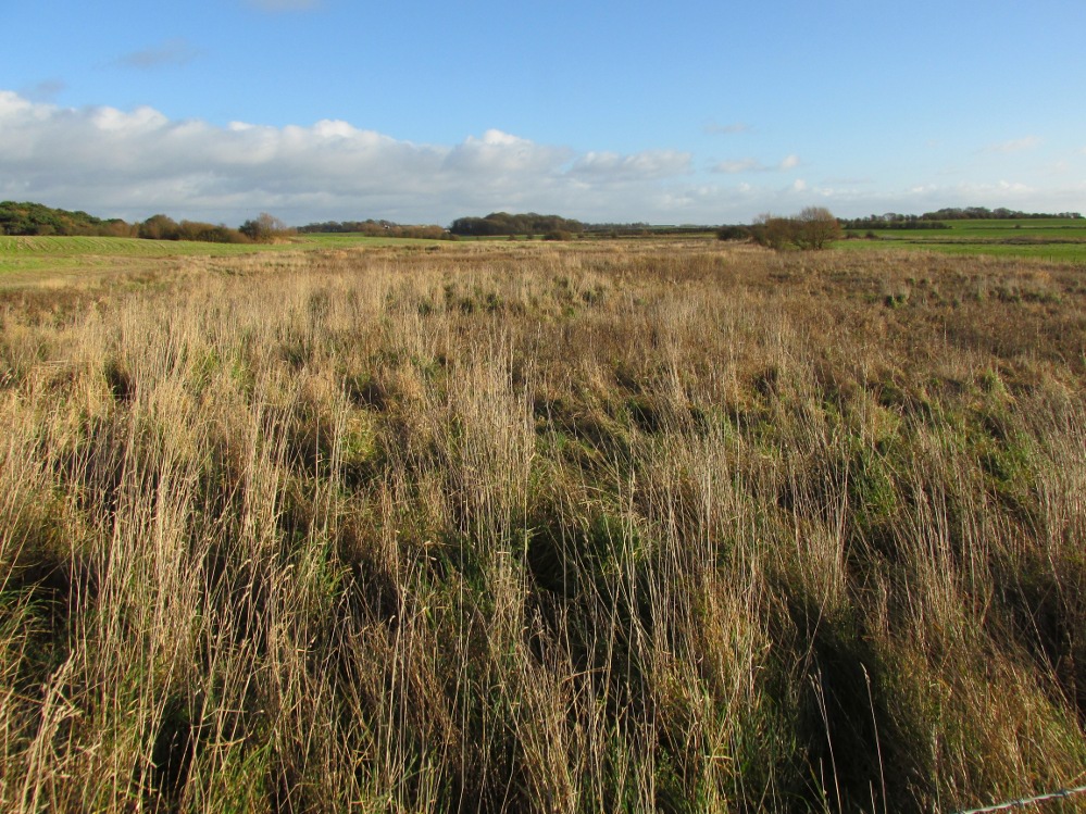
The boggy ground of the Bull Spring – from the site of possible cairn
To get here, leave Staining village along Mill Lane, turning right at the windmill along Smithy Lane. Walk along Smithy Lane, then 2-300 yards past a derelict piggery on the left go into the gated trackway on the right, and Bull Meadow is to the south-east, a boggy area at the western end of OS parcel 356. Be prepared to cross barbed wire fences.
Archaeology & History
Like the Staining Wrangdomwell or Fairy Spring recorded elsewhere, knowledge of this site owes its historical survival to the writings of Blackpool cleric, Rev. William Thornber (1803 – 1885), who wrote in 1851 about the now forgotton ‘Teanla’ or Hallowe’en bonfire cairns of Hardhorn:
“…but here adjoining the cairns are attached two wells, the one celebrated as Fairy or Wrangdomwell, and the other, issuing from a huge oblong mound of stones, as Bel spring or vulgarly Bull spring, in the Bull meadows, evidently bearing the same name as Beltain Meadow in Blackpool. Here on this Hardhorn oblong cairn, ceremonies were observed for the purpose of obtaining health to the herds of the farmers of the township – to free the wheat-land from tares, weed &c. – to bring good luck to the votaries, and to enquire into the secrets of futurity.
The ceremony was thus:- first, large fires were lighted, two or three families joining at a circular cairn, the ashes of which were carefully collected. Then the white stones, which at first, had circled the fire were thrown into the ashes, and being left all night, were sought with anxious care at sunrise, when the person who could not distinguish his own particular boulder was considered fey, i.e. some misfortune would happen to him, during the course of the ensuing year¹.
As a finale, the stones recognised were thrown, as an offering, on the oblong cairn to the god or saint who presided over it, and the well, and thus, such collections were made in a succession of years, as to astonish the curious. The water of the wells also had a sovereign virtue for healing the disease of men and cattle….”
The healing procedure at the wells is transcribed in the description of the nearby Fairy Well. Mr Thornber continues:
“The site of the large circular cairn (at Bull Meadow) is not now easily to be distinguished, since Mr. Fisher, the proprietor of the field, has carted away upwards of twenty loads of the refuse that composed it, but the soil around it is burnt red and black. This farce was carried on in its pristine glory long after the reformation; for rational Christianity (sic), which had been almost lost previously, progressed but slowly in the district of the Fylde. Even the waters of Marton Mere (SW of Bull Meadow),…were held sacred.”
Perusal was made of the Schedule to the 1839 Tithe map which revealed a ‘Bull Meadow’, owned and occupied by William Fisher, and from this, its location was able to be identified on the OS map.
Possible source of the waters
Like Wrangdom Well, half a mile to the north-west, the Bull Spring issues from an area of swampy ground, and the exact place of issue was hard to pinpoint when this writer visited in December (see photo the right). The oblong cairn—if indeed that is what it is—can still be identified, about 2 feet above the marsh, it is firm to stand on but not easy to distinguish owing to the amount of vegetation.
¹ Writing in the January 1883 edition of the The Folk-lore Journal, the Reverend Walter Gregor describes ‘ristin the halla-fire’ a broadly similar Scottish ritual carried on in the Fraserburgh area up to the late 18th century.
References:
Thornber, William, ‘Traces of the Britons, Saxons and Danes in the Foreland of the Fylde,’ in Proceedings and Papers of the Historic Society of Lancashire and Cheshire, Liverpool 1852.
Tithe Map & Schedule Transcript – ‘The Township of Hardhorn with Newton’ Surveyed by Thomas Hull in 1838, with Schedule dated 1839.’
Acknowledgement: My thanks to the staff of the Local Studies Department, Borough of Blackpool Library Services for their assistance.
One and a half centuries of neglect have not been kind to the Wrangdomwell, which is now in the middle of a large area of swampy land, reached from Staining village along Mill Lane, turning right at the windmill then walking along Smithy Lane. Just before a derelict piggery on the left go into the field, and Wrong Well Meadow is on the right at the back of the piggery, with the spring issuing from the boggy ground. Be prepared to cross barbed wire fences, and to meet some friendly ponies.
Archaeology & History
Were it not for the researches and writings of an eccentric cleric, this site would almost certainly now be lost to history. The Reverend William Thornber recorded, in his 1837 History of Blackpool that:
“The fairies of our fathers…were kind good natured creatures, at times seeking the assistance of mortals, and in return liberally rewarding them. They had a favourite spot between Hardhorn and Staining, at a cold spring of water, called Fairies’ Well to this day.”
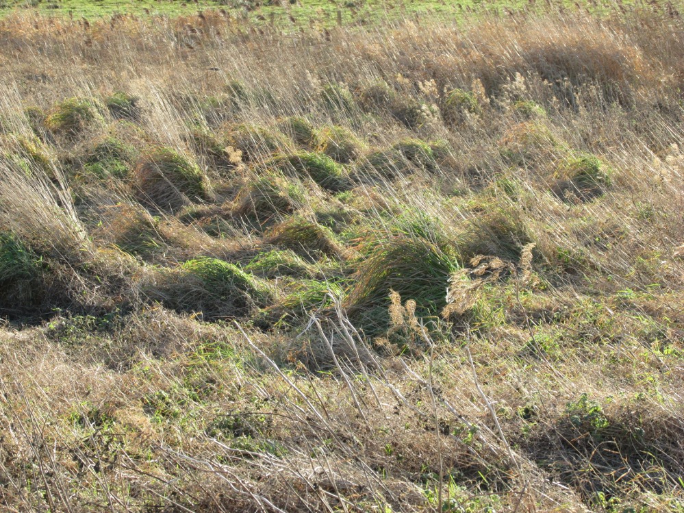
The legendary waters hide in the rushes
Writing in a paper published in 1851, Thornber described the Fairy Well or Wrangdomwell in the context of the “Teanlas”, the enormous Hallowe’en bonfires (4) that were still at that time being lit at ritual cairns of stones in parts of west Lancashire. One of these fire cairns once adjoined the Fairy Well, which in 1850 was still being visited for its,
“sovereign virtue for healing the diseases of men and cattle. To succeed in obtaining a cure, the patient, escorted by his friends, was made to pass through the cairn, then he was sprinkled or dipped in the well, and lastly, he made an offering of a shell, pin, a rusty nail or a rag, but principally three white stones burnt in the Teanla fire. It is surprising in what numbers pieces of iron may be picked up. I have found since the meadows were ploughed, nails, an old shaped knife, leather thongs etc.”
Thornber wrote that the cairn no longer existed, and gave no precise location for the well.
Looking at the area between Hardhorn and Staining on the 1891 25″ OS map revealed only one ‘spring’; in land parcel 295. This parcel of land is recorded in the Schedule to the 1839 Tithe map as ‘Wrong Well Meadow’, occupied by Thomas Dobson, and owned by ‘School of Marton’, a charitable endowment established in 1717. Adjoining Wrong Well Meadow are Old Meadow and Nickers Meadow (‘Old Nick’?), which might appear to show the Wrangdomwell as in the past having been part of a larger heathen ritual locality. Notwithstanding this, the Church was happy to take its tithe.
References:
Thornber, William, The History of Blackpool, Smith Market Place: Poulton-le-Fylde 1837 (republished in 1985 by the Blackpool and Fylde Historical Society).
Thornber, William, ‘Traces of the Britons, Saxons and Danes in the Foreland of the Fylde,’ in Proceedings and Papers of the Historic Society of Lancashire and Cheshire, Liverpool 1852.
Tithe Map & Schedule Transcript, ‘The Township of Hardhorn with Newton’ Surveyed by Thomas Hull in 1838, with Schedule dated 1839.’
Michelle Harris & Brian Hughes, in their ‘The History of the Wyre from Harold the Elk to Cardinal Allen‘ (4th ed. 2007) p35, write – “According to Tom C. Smith’s ‘History of the Parish of Chipping‘ published in 1891: ‘Teanlaes was the name given to fire celebrations, observed until quite recent years on May 1st, Midsummer Day, August 31st, and November 1st.’ These dates, it should be said, are at variance with Henry Taylor who, in his 1899 publication ‘Ancient Crosses of Lancashire’, quotes Atticus as saying: ‘The ceremony observed on Teanlow night, the last night of October, consisted of making bonfires on all the neighbouring hills.'”
Acknowledgements: My thanks to the staff of the Local Studies Department, Borough of Blackpool Library Services for their assistance.
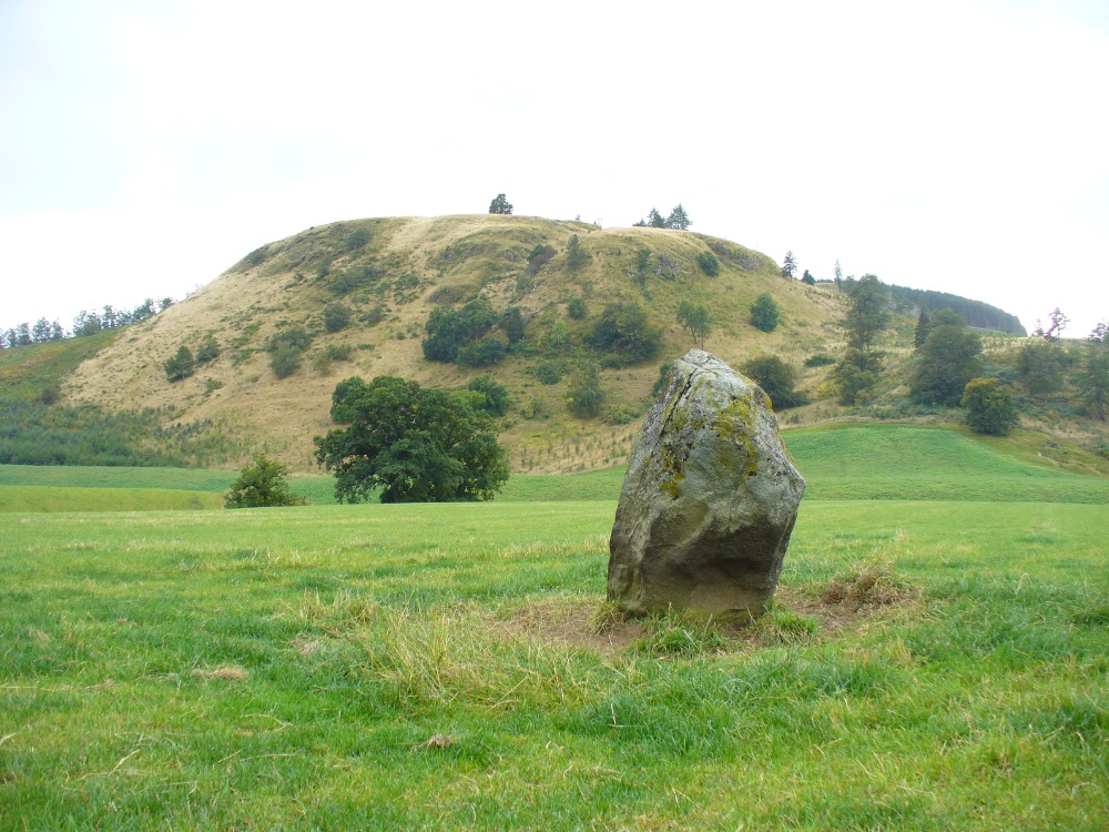
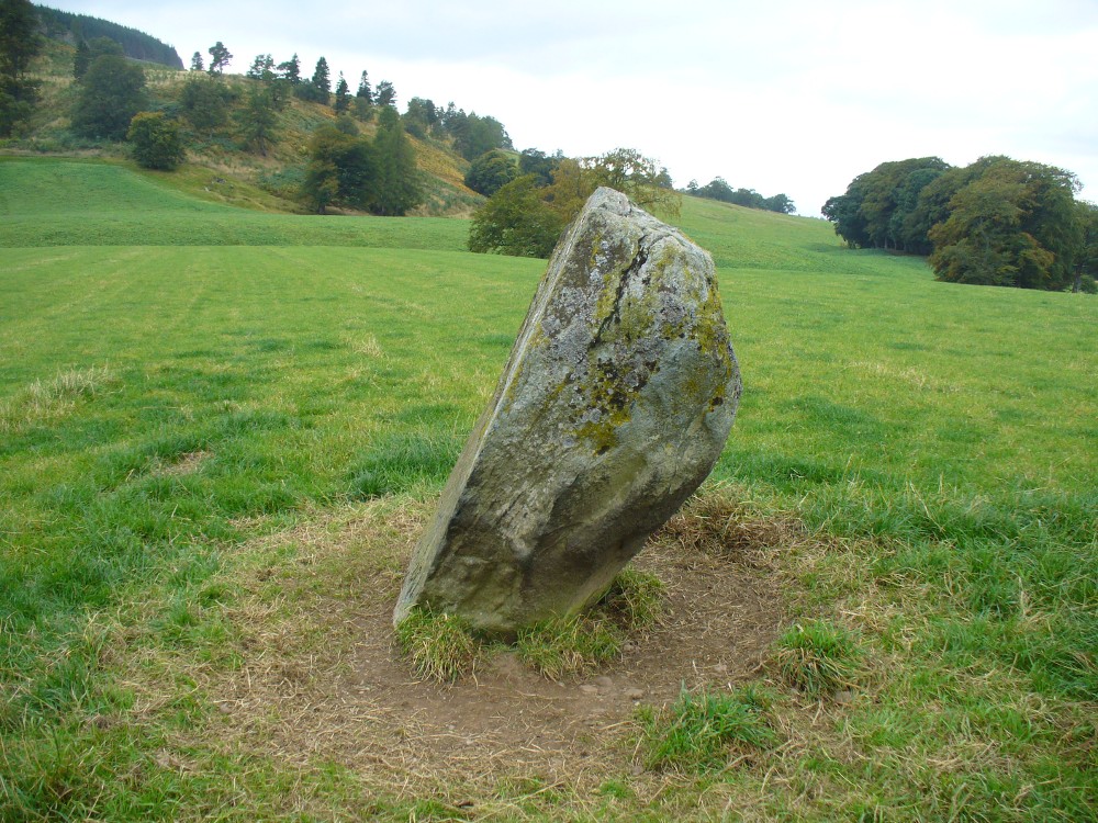
Along the A822 road past Crieff and then Gilmerton, shortly past here is a small road to Monzie and the Glenturret Distillery or Famous Grouse Experience. Go on this road and after a just a coupla hundred yards you’ll see the large old gatehouse for Monzie Castle on the left. Ask at the gatehouse and they’ll point you to the stone—in the field about 300 yards past the Monzie stone circle, 200 yards past the gatehouse itself. You can’t really miss it!
Archaeology & History
The southern flat face of the Witches Stone
This is a fascinating stone for a variety of reasons—not least of which it enabled us to identify an otherwise curious geological anomaly as an unerected standing stone some 16 miles SSW…but that’s a story for later! The stone here leans at an angle in the field, as shown in the photo, but it still rises 5 feet tall and is a thick chunky fella, with one face very flat and smoothed indeed from top to bottom. This side of the stone was obviously cut and dressed this way when first erected. As Paul Hornby then noted, its western face is also quite flat and smoothed aswell, with the edge between the two sides almost squared at right-angles. The eastern and southern sides of the stone are undressed, as the phrase goes. These physical characteristics have just been found at a newly found pair of un-erected standing stones on the western edges of the Ochils, just below a newly found cairn circle.
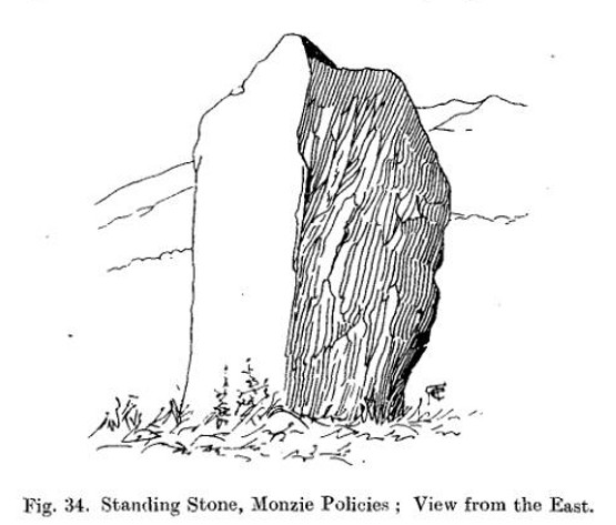
Fred Coles 1911 drawingWitches Stone, looking NE past Milquhanzie Hill fort
There were several early descriptions of this stone, two of which talked about an avenue or road along which the stone seemed to stand within. This ‘avenue’ was in fact the very edge of what is probably an earlier prehistoric enclosure—but you can’t really see this anymore unless you’re in the air (check Google Earth, which shows it reasonably well).
In J. Romilly Allen’s (1882) account, he mentions the stone only in passing, telling it to be “a single standing stone measuring 4 feet by 3 feet and 5 feet high (with) no markings on it.” It was later described in Fred Coles’ (1911) survey of the region where he told:
“This monolith is the westerly of the two prehistoric sites grouped on the O.M. as Standing Stones. It stands a few yards to the south of the avenue, almost half a mile from the East Lodge. The Stone has a slight lean towards the north. Its southern side is remarkably broad and smooth, measuring 4 feet across the base on that side, in girth 13 feet 1 inch and in vertical height 4 feet 9 inches.”
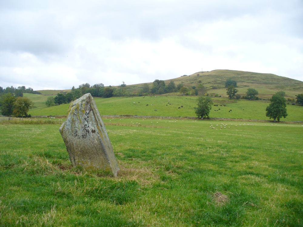
Alignment to Monzie stone circle, just visible in field
In Alexander Thom’s edited magnum opus (1980) he found that this standing stone—800 feet northwest of the superb Monzie cup-and-ring stone and associated megalithic ring—marks the midsummer sunset from the stone circle. We noted on our visit here, that this alignment runs to the distant cairn on the far northwest horizon, many miles away.
Folklore
In Joyce Miller’s (2010) excellent work on Scottish heathenism, she told the folowing tale of this stone:
“The standing stone is said to mark the site of Kate McNiven or MacNieven’s, sometimes known as the witch of Monzie, execution. The story goes that she was put in a barrel and rolled down what is now known as Kate MacNieven’s Craig on the north side of the Knock of Crieff before being burnt. Kate had been the nurse to the Grahams of Inchbrackie, and was accused of witchcraft, including turning herself into a bee. Graham of Inchbrackie tried to save her but to no avail, but as she was about to die it is said that she spat a bead from her necklace into his hand. The bead – a blue sapphire – was turned into a ring and it was believed that the ring would keep the family and lands secure. She did, however, curse the laird of Monzie, although whether this worked or not is not known. MacNiven or Nic Niven was also believed to be the name of the Queen of Fairies. Indeed it is not clear whether Kate MacNiven was a real person or is a conflation of stories. There do not appear to be any contemporary records of her execution at or near Crieff, and dates for her unpleasant death are variously given as 1563, 1615 and 1715.”
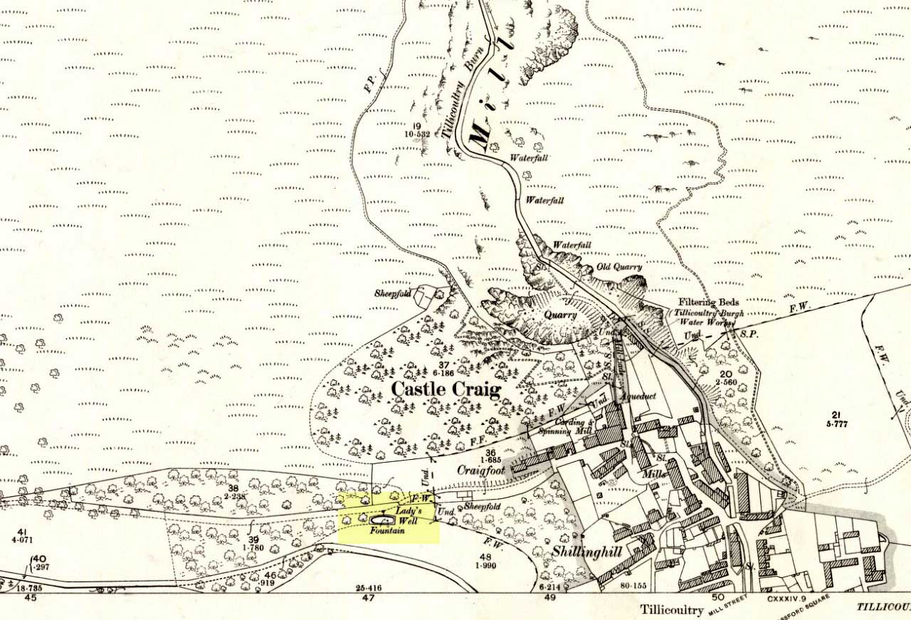
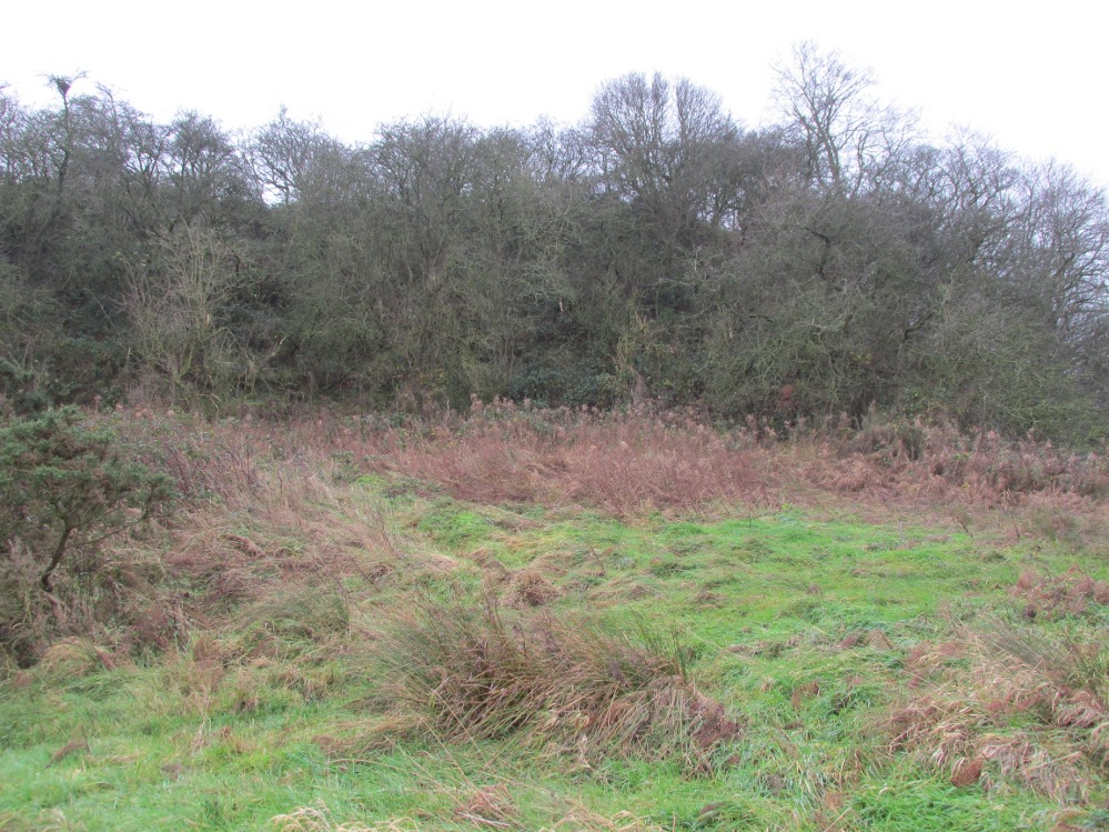
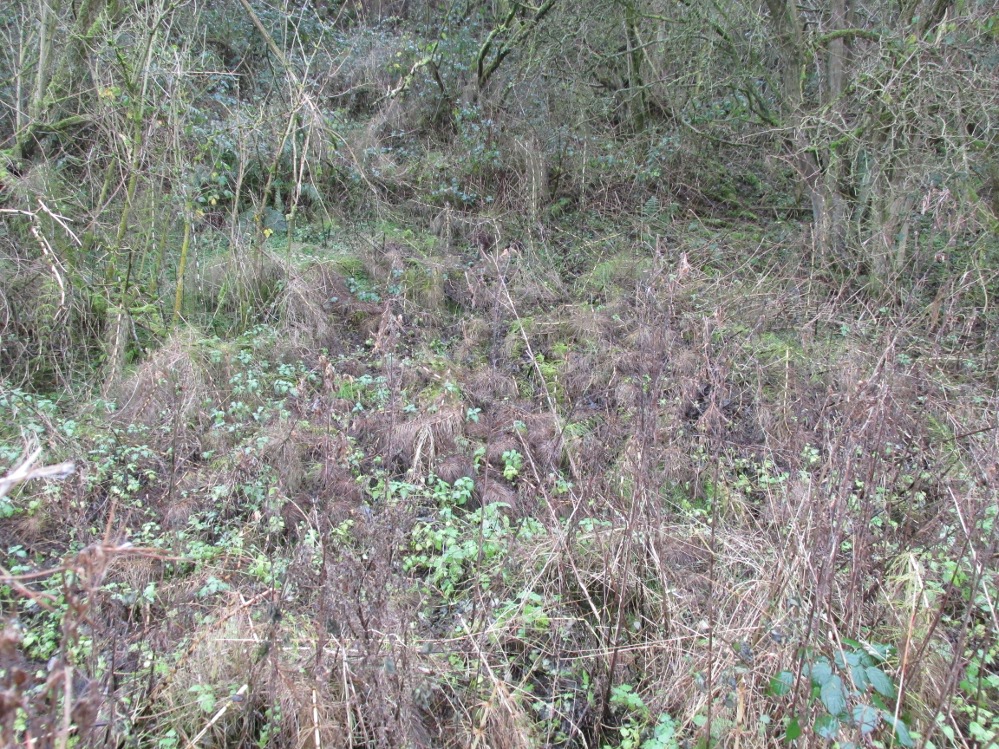
From the main road running through the town, head west towards Alva, and where the golf course begins, take the footpath uphill at its edge which heads towards the giant quarry. Where the dirt-track begins, keep walking along the edge of golf course, noting that where the open field starts, a gate on your right. Go through this, and walk up the side of the fence for some 30 yards, then go through the large gate. 10 yards in front of you, note the small stream crossing the track, and a scatter of overgrown rocks just on the other side of the wire fence. You’re here!
Archaeology & History
Thought by Angus Watson (1995) to have been possibly dedicated to ‘Our Lady’: in this context it’s difficult to know whether the dedication was to the christian Virgin, or to the heathen ‘Lady Alva’, whose web of snow and other natural garments clothe the mountains and glens of the Ochils hereby.
The first account of the place seems to be in William Gibson’s Reminiscences (1883) where he told that,
“In the year 1839, a Mr John Henderson built the only woollen mill…the water for the steam engine of which was got from the Ladies Well”,
Ladys Well on 1899 map
which was barely 100 yards to the west. It was later highlighted on the OS-map in 1899 with an associated ‘fountain’, right by the track-side. A water-pumping station shown at the same time on another map was, of course, the one that was built to supply the mill with water.
The present water source is slightly higher in the field than when it was shown on the early OS-maps, and it does still flow continuously—although the source is much neglected and could do with being recovered: as the photo here shows, an ugly pipe appears to be taking much of the healing waters which are now mainly feeding a large pond in the garden just below.
References:
Gibson, William, Reminiscences of Dollar and Tillicoultry, Andrew Elliot: Edinburgh 1883.
Go west out of Callander on the A84 road and after a mile or so turn left at Kilmahog, down the A821. After a few hundred yards, past the parking spot by the roadside, look up the small Bochastle Hill on your right and you’ll see a large singular boulder resting on top. That’s it!
Archaeology & History
When I first wandered up to this giant rock, I was hoping there may have been cup-markings on its surface, but none could be found. The stone is a glacial erratic. The Iron Age hillfort of Dunmore is 370 yards (338m) to the southwest.
Folklore
Samson Stone, close-up
In Mr Rogers’ (1853) fine historical tour of the region, he notes the Samson Stone “on the summit of one of the eminences of Bochastle,” a couple of miles west of Callander, but wondered “how it came to occupy this remarkable position.” If he’d have asked some of the old locals they may have told him what Rennie McOwan (1996) came across and described in his excellent work on the folklore of Scottish mountains. For the Samson Stone was traditionally thrown here by one of the Fingalian giants in ancient times. It was originally located upon Ben Ledi, nearly 3 miles northwest, and was one of several stones being thrown in a competition to see who was the strongest of the giants — and Samson was the name of the one who threw this huge rock. Another version of the same legend tells that the stone was originally thrown from Ben Lawers, 21 miles (34km) to the north.
References:
Bain, William, Around and about Callander, Callander & District Round Table n.d. (c.1978).
Go north on the A5026 from the town of Holywell for about 3 miles; at the hamlet of Lloc take the turning first right towards Trelogan village for another mile – the ancient cross stands in the corner of a field at the junction of 3 roads at the turning from Whitford to Trelogan, halfway between Whitford and Sarn. The cross can also be reached via Pantasaph from the A55.
History
The cross probably dates from 1000 AD and is said to be the tallest wheel-headed cross in Wales, standing at 11 feet 3′ in height. The metal fence surrounding the cross spoils the monument quite a bit, but it is there for security reasons. It is richly decorated on all sides and on the cross-head. Much of the decoration is Celtic in origin, but there are also Viking influences here, probably Northumbrian. On the south face there is a human figure standing on a serpent that has associations with the Norse god Odin; also a three-legged horse that may also be connected to Odin. The north-west face has Celtic pattern-work in the form of the letter “X” and below that another figure (naked) holding a spear. The north-east face is rather eroded, but there is some Celtic-style decoration. There is more knotwork and chainwork elsewhere on the cross with other animal figures. The wheel-head has a distinctive central boss and a four star-shaped cross radiating from the boss.
Folklore and Legend
The cross is also called ‘The Stone of Lamentation’ because penances were carried out at the cross in the Middle Ages. This act would have concluded with weeping and the ‘act of contrition’ by pilgrims visiting the site whilst making their way between St Winifred’s Well and St David’s. Legend says that St Cwyfan, a local 7th century Celtic saint preached on this site and set-up the cross – hence the name, Maen Achwyfan. One local legend tells us that Queen Boudica fought her last battle against the Romans close by in the fields called ‘Cydio ar Leni’ or ‘The fields of the seizing legions’. During the Middle Ages the monks of Basingwerk Abbey preached at the cross and also set up a chapel for pilgrims just to the south at Whitford.
References:
Allen, J. Romilly, “Celtic Crosses of Wales”, in Archaeologia Cambrensis, 1899.
Owen, Rev. Elias, Old Stone Crosses of the Vale of Clwyd and Neighbouring Parishes, Bernard Quaritch: London & Oswestry 1886.
Sharkey, John, Celtic High Crosses of Wales, Carreg Gwalch: Llanrwst 1998.
Westwood, J.O., Lapidarium Walliæ – The Early Incised and Sculptured Stones of Wales, Oxford University Press 1879.
Standing Stone (destroyed): OS Grid Reference – NG 520 144
Folklore
This once-famous standing stone appears to have gone. It was described in Otta Swire’s (1961:230) superb book on the folklore of Skye, where she wrote:
“Overlooking Elgol is Bidein an Fhithich. Near here once stood the famous Raven’s Stone, about which the Brahn Seer prophesied. It is believed that this prophecy, however, can never be fulfilled, as seventy or eighty years ago the stone was broken up and the main portion of it is now incorporated in one wall of the Glendale church, according to the Rev. A. R. Forbes’ Place Names of Skye. The stone was believed to have had some connexion with old pagan religious ceremonies.”
The Brahn Seer (more commonly known as the Brahan Seer) was Coinneach Odhar, a 16th century prophet who is said to have foretold the Battle of Culloden and other events.
References:
Swire, Otta F., Skye: The Island and its Legends, Blackie & Sons: Glasgow 1961.
 This is the first detailed guide ever written on the holy wells and healing springs in and around the ancient city of Edinburgh, Scotland. Written in a simple A-Z gazetteer style, nearly 70 individual sites are described, each with their grid-reference location, history, folklore and medicinal properties where known. Although a number them have long since fallen prey to the expanse of Industrialism, many sites can still be visited by the modern historian, pilgrim, christian, pagan or tourist.


002")