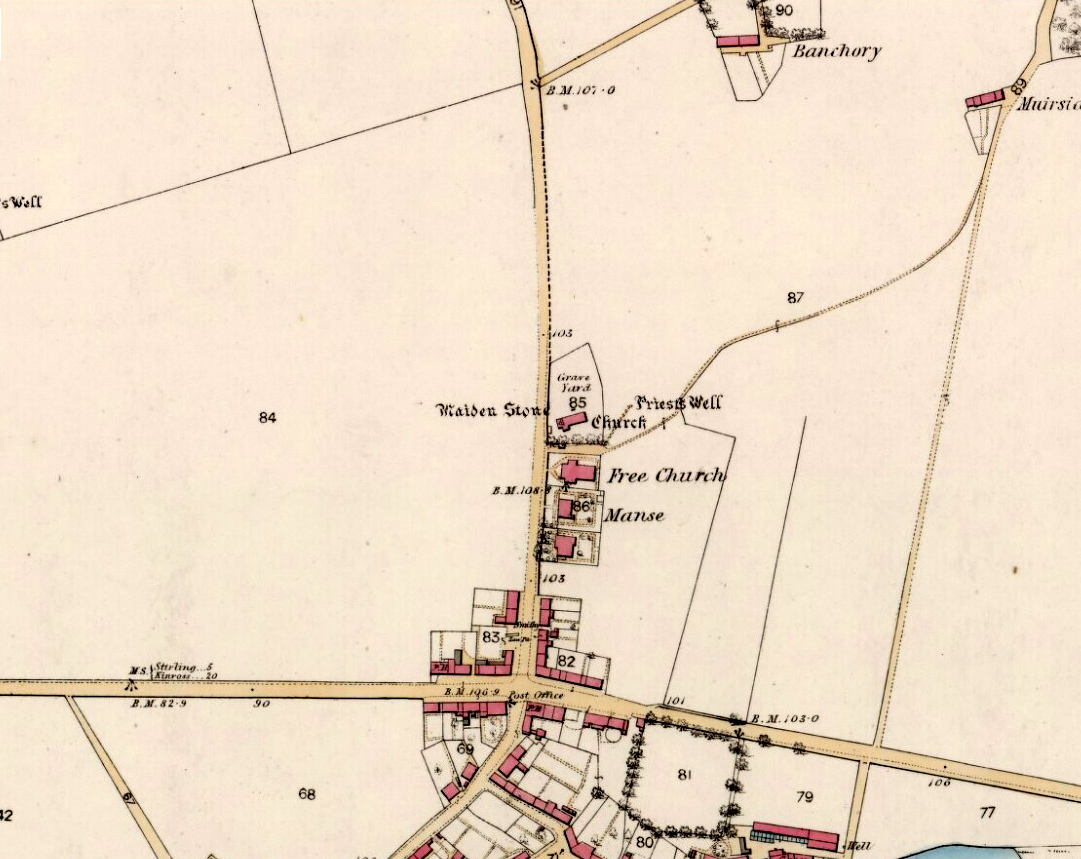
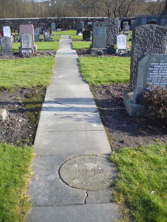
Along the A907 Stirling to Alloa road, turn onto the B9096 through Tullibody, turning up Menstrie Road until, on your right, you reach the old graveyard. Walk along the track past the old section and go into the new graveyard. The second pathway down, keep your eyes peeled on the floor and you’ll see it.
Archaeology & History
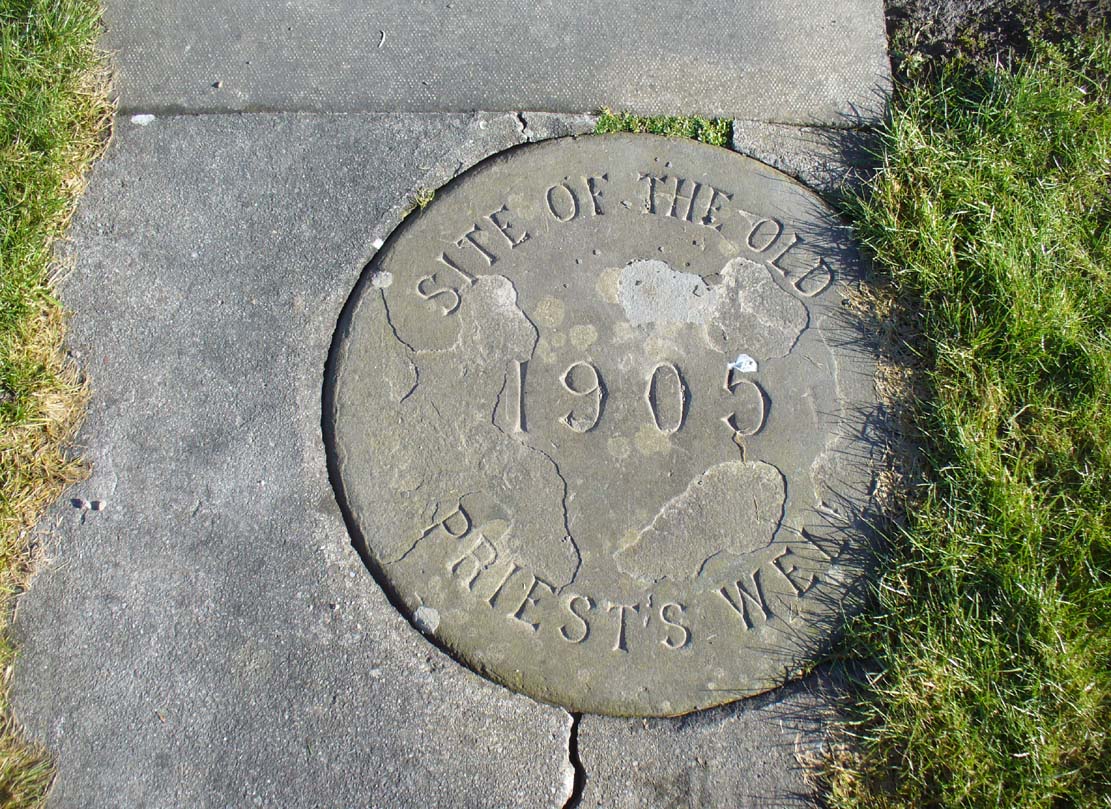
Just a flat carved stone laid in the expanded graveyard is all that remains to mark the site of this once sacred well. On it, the inscribed slab reads, “Site of the old Priest’s Well – 1905.”
In the 19th century when the waters were still used by local villagers, Robert Kirk (1890) wrote the following,
Site of the old well
Carved commemorative stone
“Like the trees, we will now keep outside the dyke (round the old graveyard) and come to the Priest’s Well. This well, an adjunct of the ancient building, appears to be coeval with the Old Church, and lay a few yards south of the Parsonage, which was demolished at the Reformation. A small piece of ground in the immediate vicinity is known as the ‘Priest’s Croft’, and the adjacent field, tradition imagines to be the site of the original hamlet. When this well, from its proximity to the Churchyard, was condemned as unfit for human use, one old wife was heard to exclaim, “Na, na, I aye like a drink o’ the guid sweet priest.”
Despite being cited in the various Scottish holy wells reports, all mythic history of the site seems to have been forgotten.
Kirk, Robert, Historical Sketch of Tullibody, Alloa 1890.
Royal Commission on the Ancient & Historical Monuments, Scotland, Inventory of Monuments and Constructions in the Counties of Fife, Kinross and Clackmannan, HMSO: Edinburgh 1933.
Simpkins, John Ewart, County Folklore – volume VII: Examples of Printed Folk-Lore Concerning Fife, with some Notes on Clackmannan and Kinross-Shires, Folk-Lore Society: London 1914.
Walker, J. Russel, “Holy Wells in Scotland,” in Proceedings Society Antiquaries Scotland, volume 17, 1883.
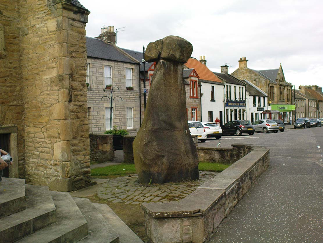
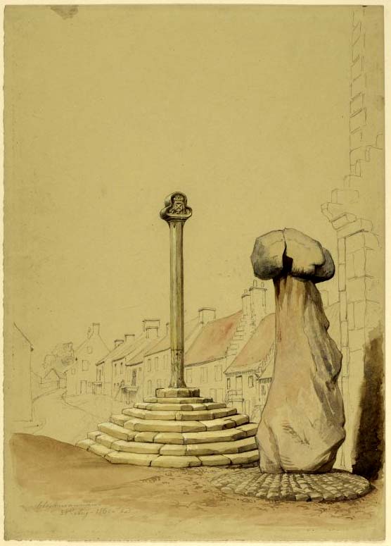
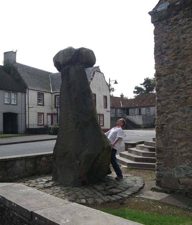
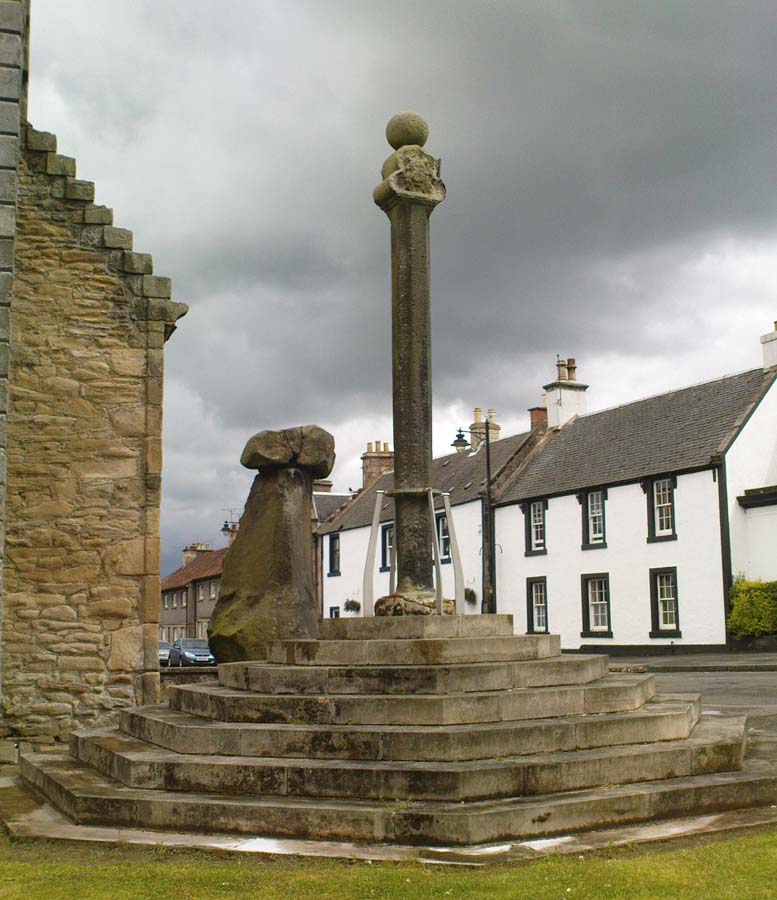
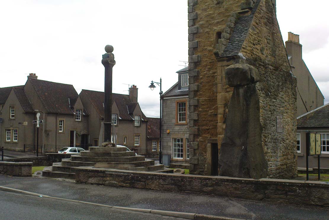
Take the A907 road between Alloa and Kincardine, and up the B910 into Clackmannan. To get into the village, depending on which route you’re coming in, go up the Kirk Wynd or the Cattle Market—both of which lead you to the Main Street where, beneath the old clock tower, you’ll see the Market Cross and its companion erection just to the side. You can’t really miss it!
Archaeology & History
The phallic upright!
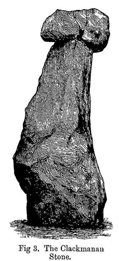
The history of this curious-looking giant phallic stone, sat quietly on the Main Street of sleepy Clackmannan village, isn’t as heathen as you’d expect when first seeing the huge upright—but there are mysteries and myths gathered about it. The county of Clackmannan itself takes its name from this stone—but not the entire stone that we see today; merely the rounded, smaller element on top. For it’s this that’s the real Mannan Stone. The rest of it, the tall upright pillar, was only attached to the smaller rounded stone—the Stone of Mannan— in the first-half of the 19th century.
First mentioned as a place-name in 12th century writings, the story of the stone was best told by Peter Miller (1889), who wrote:
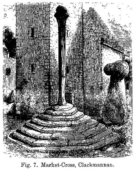
“The old ‘clack’ or stone that forms the prefix to the name-word Clackmananmust be of considerable antiquity. Its form and appearance have nothing to excite remark. The two larger portions of the stone are battened together with iron, and the portion forming the cleft appears to be detached from the larger one. It is only the legend or tradition respecting its history and its association with the name-word Clackmanan that makes it interesting to the antiquary. Its dimensions are as follows: —It is over 3 feet in length, 2 in breadth, and about the same in thickness. Its form is oval, and it has a deep cleft on its upper side. The stone has nothing peculiar about it to indicate what it may have been originally, or the uses it was made to serve in early times. There is no appearance of its ever having had an inscription or any ornamentation upon it. It is simply a boulder-stone stone of whinstone, such as are found in abundance at the Abbey Craig near Cambuskenneth. It was placed on the tall boulder slab on which it now stands, brought from the Abbey Craig in the year 1833 by the late Robert Bruce of Kennet, and the late Professor Fleming, who was then minister of the parish. Previous to that time it lay on the ground alongside of the old jail and court-house of Clackmannan, close by the old cross of the town…”
Clackmannan Stone (after Miller)
The old stone & its upright
Mr Miller then went on at some length to show the derivation of ‘Clackmannan’ to be from the old Irish, meaning “the stone of the monks.” It seems a plausible theory too. Despite this, Watson (1926) deemed it to be the ‘Stone of Manau’, being deemed vaguely as the people of the land north of the Forth. The great Celtic scholar John Rhys (1888) declared Clackmannan to derive from the Irish deity or hero-figure, Manannan, as have other academic authorities since then. But it’s all just a bit vague if we’re wanting ‘certainty’…
When T.C. Crouther (1936) wrote about this, he said how the Stone of Mannan had originally come from a position only a few hundred yards south of its present spot, at a place known as Lookabootye Brae (NS 912 911), just above where the land begins to drop down closer to sea level. This doesn’t seems too improbable. Close to this spot could once be seen the sacred site of the Lady Well.
At the turn of the 21st century the stone was caged by the local council as it was beginning to crumble and was in danger of collapse; and so, the local council repaired the great upright and its sacred top-stone—albeit at the staggering cost of £160,000!!! As the local people and other masons know to this day, the job could have been done for a fraction of that cost with equal efficiency.
Folklore
Said by T.C. Crouther (1936), the local council, and others to have got its name from the sea god Mannan, other legends have grown around this fascinating old rock. When Edwin Adams (1863) wrote about it, these were the tales that local people gave him:
“Its legendary history is curious. When King Robert Bruce was residing in Clackmannan tower, and before there was a town attached to that regal mansion, he happened, in passing one day near this way on a journey, to stop awhile at the stone and, on going away, left his glove upon it. Not discovering his loss till he had proceeded about half-a-mile towards the south, he desired his servant to go back to the clack (for King Robert seems to have usually spoken his native Carrick Gaelic), and bring his mannan, or glove. The servant said, ‘If ye’ll just look about ye here, I’ll be back wi’t directly,’ and accordingly soon returned with the missing article.
£From this trivial circumstance arose the name of the town which was subsequently reared about the stone, as also that of a farm at which the King stopped, about half-a-mile from the south, on the way to Kincardine, which took its name from what the servant said, namely, ‘Look about ye,’ and is so called to this day.”
But as the various dates in this tale simply don’t add up, it seems that the writer had been easily fooled.
Rhys, John, Lectures on the Origin and Growth of Religion as Illustrated by Celtic Heathendom, Williams & Norgate London 1888.
Royal Commission on the Ancient & Historical Monuments, Scotland, Inventory of Monuments and Constructions in the Counties of Fife, Kinross and Clackmannan, HMSO: Edinburgh 1933.
Royal Commission on the Ancient & Historical Monuments, Scotland, The Archaeological Sites and Monuments of Clackmannan District and Falkirk District, Society of Antiquaries of Scotland 1978.
Simpkins, John Ewart, County Folklore – volume VII: Examples of Printed Folk-Lore Concerning Fife, with some Notes on Clackmannan and Kinross-Shires, Folk-Lore Society: London 1914.
Small, John W., Scottish Market Crosses, Eneas Mackay: Stirling 1900.
Watson, W.J., The History of the Celtic Place-names of Scotland, Edinburgh 1926.
Take the A907 road between Alloa and Kincardine, and up the B910 into Clackmannan. To get into the village, depending on which route you’re heading in, go up the Kirk Wynd or the Cattle Market—both of which lead you to the Main Street where, right next to the huge erection known as the Stone of Mannan you’ll see the old Cross on its steps.Getting Here
Archaeology & History
When the Royal Commission (1933) lads wrote about the site in their early survey, they called it the Burgh Cross, telling:Found in association with the village Tolbooth and the more famous Stone of Mannan, this probable 16th century cross stands at the meeting of the four lanes at the centre of the village in the heart of Clackmannanshire. It was the focal point of an annual market fair which, said Craig Mair (1988), “could last up to eight days”. It was the meeting place of local villagers where legal issues were called and settled, where bonds and deeds were made and, in all probability, replaced an earlier non-christian monument.
The Mercat CrossMillers 1889 sketch
“Although the stepped base has been renewed, the shaft is original. It is 9 feet 6 inches in height and is octagonal in section, measuring 11 inches in diameter. The capital is moulded and has on the east side a shield enclosed by swags and bearing a saltire and chief, for Bruce. A second shield, carved on the west side, has apparently been similarly charged, but is now very weatherworn. The ball finial on the capital was removed in 1857, but replaced in 1897.”
The reference to the chief, Bruce, is said by tradition to be that of Robert the Bruce. This element in the cross’ history has been transposed mistakenly by early english writers onto the adjacent Stone of Mannan.
Cross & Mannan’s Stone
In recent times both the cross and the Stone of Mannan were repaired, at a staggering cost of £160,000. How the hell it cost that much is anybody’s guess – but it certainly sounds as if someone’s pockets would have been bulging!
References:
Mair, Craig, Mercat Cross and Tolbooth, John Donald: Edinburgh 1988.
Royal Commission on the Ancient & Historical Monuments, Scotland, Inventory of Monuments and Constructions in the Counties of Fife, Kinross and Clackmannan, HMSO: Edinburgh 1933.
Royal Commission on the Ancient & Historical Monuments, Scotland, The Archaeological Sites and Monuments of Clackmannan District and Falkirk District, Society of Antiquaries of Scotland 1978.
Simpkins, John Ewart, County Folklore – volume VII: Examples of Printed Folk-Lore Concerning Fife, with some Notes on Clackmannan and Kinross-Shires, Folk-Lore Society: London 1914.
Small, John W., Scottish Market Crosses, Eneas Mackay: Stirling 1900.
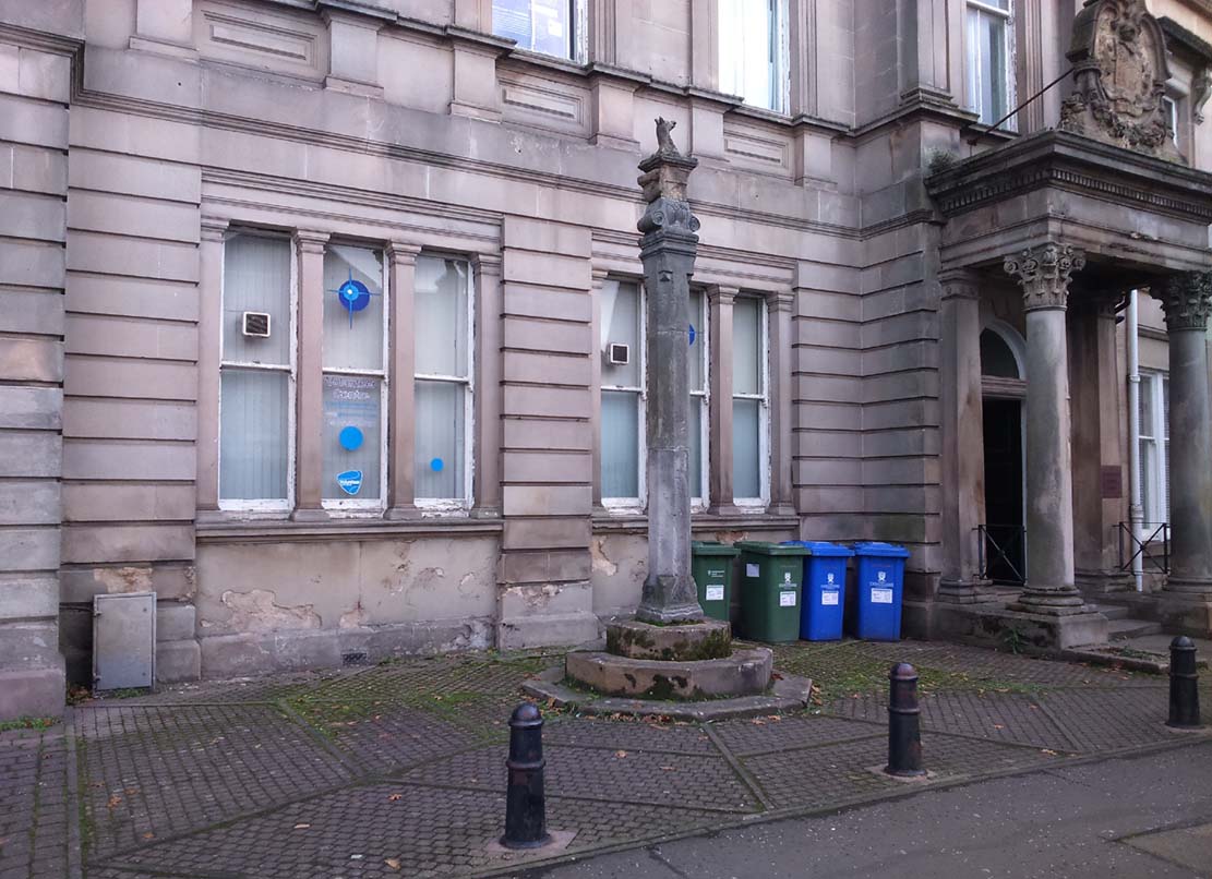
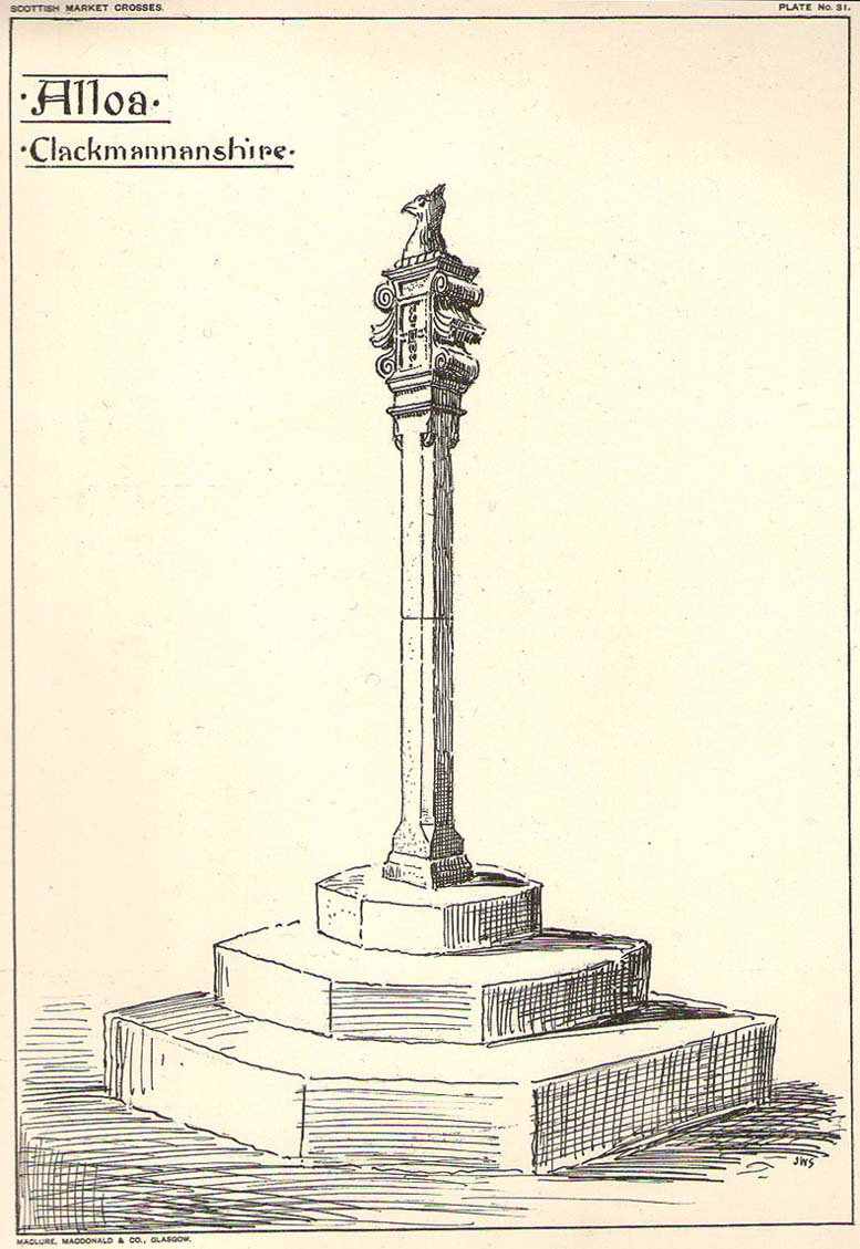
Get into the small town of Alloa, where the buses stand at Shillinghill. From here walk southwest down Mill Street, which runs into Bank Street. Keep your eyes peeled on your right-hand side, where outside one of the old municipal buildings you’ll see it standing upright.
Archaeology & History
Although now standing against the old buildings halfway down Bank Street, Alloa’s Mercat or Burgh Cross was initially set up at the crossroads 162 yards (148m) away, where Mar Street meets Mill Street and Bank Street. It was moved to its present position sometime in the 1880s and knowledge of its early history is scant.
Standing some ten feet high, the monument was described in John Small’s (1900) rare magnum opus, in which he detailed the architectural features of the monument, telling us that,
John Small’s sketch
“The shaft, which rests on a base and three steps, is of the usual square section, with splayed angles, stoped at top and bottom, the top stop being rather peculiar.
The head of the Cross is composed of an oblong stone set upright, characteristic of the late type seen in Keikleour and Kinrossie. The oblong is ornamented at the sides with debased volutes and acanthus leaves, the whole crowned by a wreath from which rises a griffin’s head, part of the supporters of the Arms of the Lords of the Manor, Lord Mar and Kellie.”
References:
Anonymous, The Alloa Illustrated Family Almanac, MacGregor & Steedman: Alloa 1887.
Mair, Craig, Mercat Cross and Tolbooth, John Donald: Edinburgh 1988.
Royal Commission on the Ancient & Historical Monuments, Scotland, Inventory of Monuments and Constructions in the Counties of Fife, Kinross and Clackmannan, HMSO: Edinburgh 1933.
Small, John W., Scottish Market Crosses, Eneas Mackay: Stirling 1900.
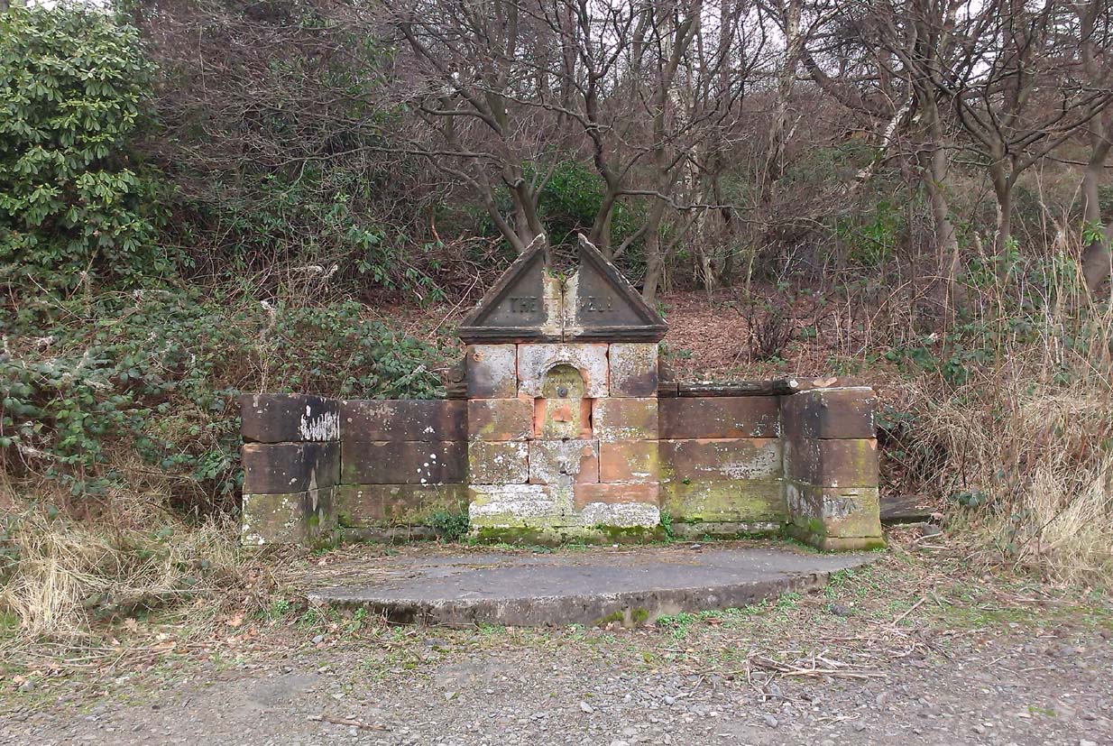
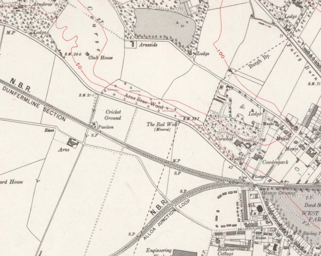
Along the A907 a mile west of Alloa and heading towards Tullibody, just before the roundabout across the road from the school fields, a small entrance takes you into the small wooded parkland. There, right in front of you as you walk in, and visible from the road, is the enclosed architectural stone walling and somewhat ruinous remains that are the Red Well, with its faded name carved on top.
Archaeology & History
Red Well on 1913 map
Although the waters no longer run for the people to drink, this old iron-bearing spring was long of repute to the old folk of eastern Alloa. So much so, it seems, that even Janet & Colin Bord (1985) included it in their national survey of sacred wells! Like other chalybeate springs, its waters were known to be good as a tonic—which makes sense as iron fortifies the blood and general immune system. The Well was highlighted on the 1913 OS-map of the area.
References:
Bord, Janet & Colin, Sacred Waters, Granada: London 1985.
From the railways station, walk to the dual carriageway (crossing the road) and walk on the A907 road to your left; cross the next road & walk round the corner, crossing the next road by the zebra crossing. OK, walk to your right, bearing immediately left down Devon Road, then just 20 yards on take the footpath up the side of the house on your left, and keep walking until you go into the trees. Then keep your eyes peeled for the fairy mound with a rock on top of it!
Archaeology & History
Overgrown cairn, looking NE
This is a large rounded, almost archetypal tumulus, sitting just a couple of minutes walk out of Alloa town centre, sandwiched between streets in the remaining copse of trees running east-west along Hawk Hill. Although the mound is of considerable size—with a large curious block of stone plonked on top—it hasn’t always been like that and has evidently been rebuilt sometime in the 20th century, for when the Royal Commission (1933) lads visited the site in July 1927, they reported only a bare trace of the old tomb, saying:
“The site of the cairn at Hawk Hill lies about 100 yds SSE of the lodge gate. The position is marked by a setting of young trees, but the ground has been cultivated and no definite outline of any structure can now be traced. A few loose stones of no great size, lying scattered about, are the only signs of a cairn.”
But the site is quite large, being more than 4 feet high and about 18 yards across, with a large flattened circular top. Nearby there was reported to have been another cairn, but this turned out to be little more than some recent debris.
Folklore
Local folklore tells that this monument is along a ley line that links it with the Hawk Hill Cross and destroyed stone circle east of here and the remains of a little-known standing on the outskirts of Alloa, to the west. I’ve not checked the precision of this alignment, but a quick scan of it looks pretty decent!
References:
Arabaolaza, Iraia, “Hawk Hill, Alloa,” in Discovery & Excavation in Scotland, New Series volume 10, 2009.
Royal Commission on the Ancient & Historical Monuments, Scotland, Inventory of Monuments and Constructions in the Counties of Fife, Kinross and Clackmannan, HMSO: Edinburgh 1933.
Royal Commission on the Ancient & Historical Monuments, Scotland, The Archaeological Sites and Monuments of Clackmannan District and Falkirk District, Society of Antiquaries of Scotland 1978.
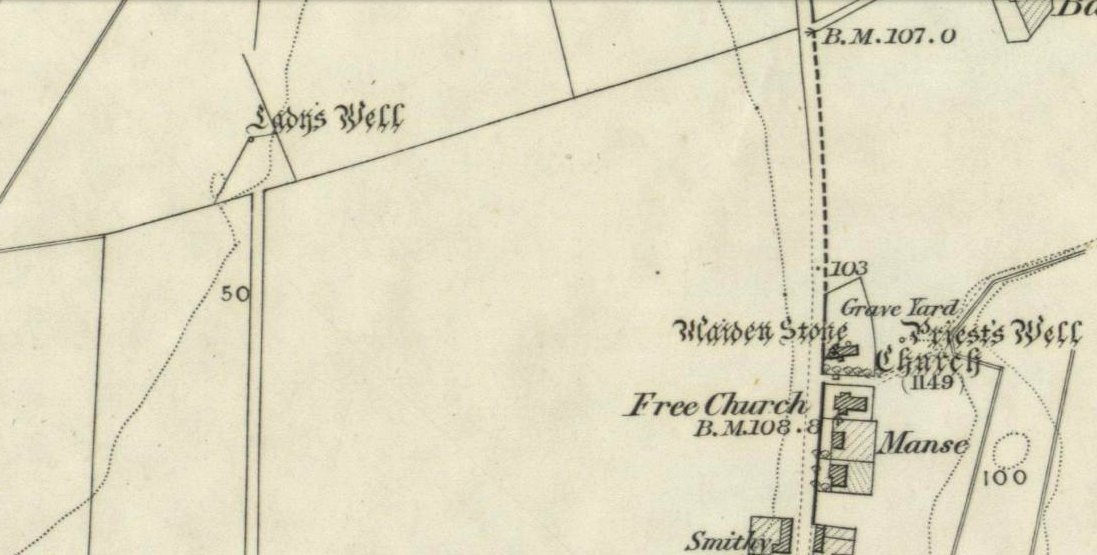
My initial thoughts about this holy well, was that it had been destroyed—but thankfully I was wrong. It had been intruded upon by roadworks along the B9140, with the original water source affected, but it was re-routed and can still be found below the south-side of the main road. It was highlighted on the 1866 Ordnance Survey map of the area When the Royal Commission (1933) lads visited the site in 1927 they told that,
“It has no features of special interest. It is 4′ in diameter, but is so much filled up with stones and debris that it is now not more than 2′ deep.”
The site was mentioned in Ruth & Frank Morris’ (1982) survey, but with no additional information. I’ve not been able to find out whether the ‘lady’ of this well was a saintly woman of religious importance, or just one of us commoners! Does anyone know?
Royal Commission on the Ancient & Historical Monuments, Scotland, Inventory of Monuments and Constructions in the Counties of Fife, Kinross and Clackmannan, HMSO: Edinburgh 1933.
From Clackmannan Main Street, go down the Cattle Market and straight across at the junction, downhill. Keep going on the country lane for half-a-mile watching out for Grassmainston Farm on the left. Go past here and up the next dirt-track for a few hundred yards, watching out for a copse of trees on your left a coupla hundred yards away. Go to the very top corner of the copse, following the stream to its source. That’s it!
Archaeology & History
In a truly fascinating historical case of witchcraft (there was a lot of it in this area according to court and church records), heard in Clackmannan on 16th July, 1700, a certain spring of water, or well, was described, where acts of healing and sympathetic magick were performed and, it would seem, was quite well known to the people cited in the case. It seems very likely from reading the account, that the well in question had magical repute locally. The well was not named, but thankfully the information in the case has allowed us to identify the place in question. When I came here a month or two ago, the well was very overgrown (hence the poor photo above), so I’m gonna go back for another look at the place when Winter’s brushed back the vegetation.
The tale surrounding the well was included in Simpkin’s (1914) Folklore Society survey of Fife and Clackmannan a hundred years ago, and is as follows:
“John Scobie, younger, in Clackmannan, was called, who being of age thirty-eight, was sworn and interrogated if he went up with his uncle to a south-running well at Grassmainston. Deponed that he did go up with him, alone, the first night, and as his uncle was casting off his clothes at the well, the deponent saw a black man …coming from Kersemill; and when he came to the head of Robert Stupart’s folds there was a great squealing among the cattle. Also, when deponent had his uncle down to sprinkle him, he saw a brindled cat come out from among the corn within a little distance from him. He put magic powders upon his uncle when he was naked, which he had received from his said uncle’s wife, Margaret Bruce, who remarked to the deponent that the woman who directed (them), “would get a flee before he came back”; and that, at his return, at Goldney, he heard a terrible noise as of coaches, and that he was dripping of sweat when he came into the house.
“The said Margaret had forbidden them to speak in going or coming, which injunction they observed. When they came to call the deponent to go the second night he refused, till the deceased Robert Reid came and took him, and they both went with him, and saw the black man and the cat, and heard the cattle squeal as aforesaid and, when they were coming back again, there came a great wind upon the trees on the side of the Devon and, when he was crossing the Cartechy Burn his uncle’s foot slipped and he fell in the burn. Thereupon Robert Reid said, “The cure is lost. There is no helping of you now!” And so they spoke from thenceforth until they came home; for Margaret Bruce, the said James Scobie’s wife, told them that if he fell into the water he would not be cured. The witness further added that when they told Margaret that her husband had fallen into the water, she wept. ”
The magickal well in this case would appear to be one identified at the very top of the small copse of trees immediately north of Grassmainston farmhouse, just 3-400 hundred yards away up the slope. It is a “south-running well” as cited in the case and no other water source is immediately apparent. It would be good if any students or antiquarians living near Alloa could check local library records and see if there’s any further information about this site. A short distance north of here is the curiously-named ‘Serpent Wood’, with its old well, fallen stone and lost legends…
…to be continued…
References:
Simpkins, John Ewart, County Folklore – volume VII: Examples of Printed Folk-Lore Concerning Fife, with some Notes on Clackmannan and Kinross-Shires, Folk-Lore Society: London 1914.
From Alloa head east along the A907 road and park up at Morrison’s supermarket a half-mile on. From here, keep walking along the same road, but make sure you go on the dirt-track running parallel with the main road, and which runs alongside the field in which this monument is clearly visible. Just make sure you only visit it when the crops aren’t growing (between September through to April is OK).
Archaeology & History
This is a highly impressive monument, but I for one doubt that it has a wholly christian origin… The fact that a stone circle was on the same ridge totally visible a couple of hundred yards away, and a cluster of Bronze Age cairns immediately west, adds to my doubt; along with the sheer size of this thing trying to grab attention to itself. You’ll have to visit it yourself and see what I mean.
The stone was first described in the Old Statistical Account of the area in 1795, and it told:
“About a mile east of the town, there is a large upright stone, 7 feet 4 inches above the surface of the ground. It is three feet broad, and thought to be very deep in the Earth. The old people used to speak of the figure of a man on horseback, which they had seen on it. If any thing of that kind, or letters (as it is said), have been formerly observed, they are now totally effaced.”
However, in a footnote to this entry, it was said that,
“when the adjacent farm was enclosing, upwards of 20 years ago, a ditch was made close to the stone, when many human bones were discovered; which proves that a battle or skirmish had some time or other taken place near that spot; and probably some man of eminence was buried hard by, as it was a common practice of the Picts on such occasions. There are two stones resembling this one, in the neighbouring parish of Alva, at no great distance from the church, but not close to one another. They are both near the foot of the Ochils.”
It seems most probable that this great cross-carved monolith had some relationship to our heathen mythic history—an idea which has been put forward by others historians in bygone times. In Daniel Wilson’s (1851) huge work, he told us:
“On ground about half a mile to the east of the town of Alloa, called the Hawkhill, is the large upright block of sandstone sculptured with a cross which is represented in the annexed engraving. It measures ten and a quarter feet in height, though little more than seven feet are now visible above ground. A similar cross is cut on both sides of the stone, as is not uncommon with such simple memorials. During the progress of agricultural operations in the immediate vicinity of this ancient cross, in the spring of 1829, Mr. Robert Bald, C.E., an intelligent Scottish antiquary, obtained permission from the Earl of Mar to make some excavations around when, at about nine feet north from the monumental stone, a rude cist was found, constructed of unhewn sandstone, measuring only three feet in length, and at each end of the cover, on the under side, a simple cross was cut. The lines which formed the crosses were not rudely executed, but straight and uniform, and evidently finished with care, though the slab itself was unusually rude and amorphous. The cist lay east and west and contained nothing but human bones greatly decayed. Drawings of the cross and a plan of the ground, executed by Mr. Bald, are in the possession of the Society of Antiquaries. Here we possess a singularly interesting example of the union of Christian and Pagan sepulchral rites: the cist laid east and west, according to the early christian custom, yet constructed of the old circumscribed dimensions, and of the rude but durable materials in use for ages before the had superseded the aboriginal Pagan creeds.”
Old drawing of the site (after Wilson 1851)Hawk Hill Cross, looking north
A few years later there was another account of this cross published in the Proceedings of the Society of Antiquaries, Scotland (1889), echoing much of what Wilson described, telling of the discoveries of many human remains found hereby. And when the Royal Commission (1933) account of the place was written after their inspection team visited the site in 1925, they told:
“This slab…is set up on a knoll about 200 yards south of the main roadway between Alloa and Clackmannan and about midway between the site of the (Hawk Hill) cairn…and that of the (Hawk Hill) stone circle… It is packed round the base with fairly large stones and stands with its broad faces east and west. A cross of Celtic form is incised on both sides, the incisions being about half an inch in depth. On the east face the shaft is made to spring directly from a base, without the intervention of a basic line. The design on the west face is similar, but the shaft here has been almost entirely obliterated by weathering. The slab is 8 feet in height, 2 feet 7½ inches in width at the base, and 9 inches in thickness.”
Notice that the more recent accounts don’t mention the horse carving: an intriguing element which was however mentioned in some early local history works of the place. Indeed, some postulate that this may have Pictish origins. They may be right. As local historian T.C. Gordon (1937), told,
“that the old people of the parish could remember seeing on the soft surface of the stone the figure of a man on horseback.”
Cross on the east faceCross on the west face
On the day I visited this stone I couldn’t make out any carved horse, but it seemed that something may once have been carved near the bottom the western face…perhaps… One writer also suggested that the nearby place-name of Gaberston may have related to this stone cross, with the word literally meaning ‘The Pillar Stone of Brath (Brude),’ which as Mr Gordon said, thus provides “the link between the stone and (the Pictish leader) Brude, and this link is strengthened when we remember that the burn that runs through Alloa is called ‘the Brathy Burn.’”
The possible Pictish motifs of a horseman were mentioned again in a letter from the local County Planning Officer to the Alloa County Clerk in 1971, along with a recommendation that the cross be removed and placed into a museum to prevent further weathering and erosion. Thankfully this suggestion was not followed through and the cross remains where it belongs: in its position in the landscape to beguile and intrigue us over its hidden commemorative past. Long may it remain upon its hill.
A very impressive site indeed…
Folklore
Thought locally to have played a part on an alignment or ley line with a little-known Druid Stone by the roadside in Alloa, the Hawk Hill cairn, and Hawk Hill stone circle to its east. The historian T.C. Gordon (1937) told that the cross marked the site where the Picts fought against the Saxons, saying:
“We know that Finguine, son of Deleroith, died in that battle in 711 AD, and maybe Brude too. A stone cross still marks the place at Hawkhill.”
References:
Gordon, T. Crouther, A Short History of Alloa, Alloa Advertiser 1937.
Lothian, James, Alloa and its Environs, Alloa Advertiser 1861.
Miller, Peter, “Notices of the Standing Stones of Alloa and Clackmanan,” in Proceedings of the Society of Antiquaries, Scotland, volume 23, 1889.
Royal Commission on the Ancient & Historical Monuments, Scotland, Inventory of Monuments and Constructions in the Counties of Fife, Kinross and Clackmannan, HMSO: Edinburgh 1933.
Wilson, Daniel, The Archaeology and Prehistoric Annals of Scotland, Sutherland & Knox: Edinburgh 1861.
Stone Circle (destroyed): OS Grid Reference – NS 906 925
Archaeology & History
Clump of trees near the site of the olde circle…
This is another megalithic ring that appears to have been destroyed, sometime around 1923. It was one of a series of very important Bronze Age monuments that could once be seen along the ridge of Hawk Hill on the eastern outskirts of Alloa. A series of important prehistoric tombs scattered the area, and a tall early medieval cross was erected near the site to try christianize this important heathen arena. Sadly, we have few details available of the circle itself. The Royal Commission (1933) report simply said of it:
“This circle occupied a site immediately behind the lodge at the eastern extremity of the same (ridge) as the cairn (on Hawk Hill). It was, we are informed, entirely removed about ten years ago.”
In the cultivated field there is a curious circular clump of trees which I thought might harbour some of the fallen monoliths, but a scattering of overgrown stones within them did not have that prehistoric pedigree about them. Perhaps better luck might be had in the trees at the end of the field… The tall Hawk Hill Cross can be seen just a couple of hundred yards or so immediately to the west.
References:
Royal Commission on Ancient & Historical Monuments, Scotland, Fife, Kinross and Clackmannan, HMSO: Edinburgh 1933.


")


