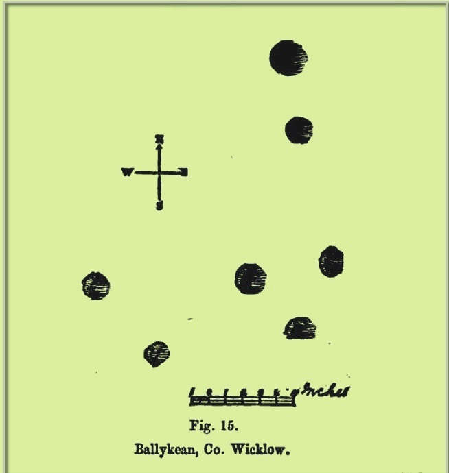
This is one of at least fourteen petroglyphs in this parish that have been either lost or destroyed since their initial description in the 19th century. It was described in George Kinihan’s (1884) survey as a “flat irregular stone, sloping slightly towards the east: the cups are seven in number”, in a design similar to that of the constellation of Cassiopeia. When the Archaeological Survey of Ireland looked for the carving in 1990 it could not be located. Corlett (2014) suggests that a collection of rocks in a hollow to the north may conceal this and some of the other carvings in this cluster.
References:
Corlett, Christiaan, Inscribing the Landscape: The Rock Art of South Leinster, Wordwell: Dublin 2014.
Kinihan, George H., “Proceedings: Cup-marked and Inscribed Stones in the Counties of Wicklow and Wexford”, in Journal Royal Society Antiquaries Ireland, (4th series) volume 6, 1884.
Cup-Marked Stone (lost): OS Grid Reference – SG 21584 42271
Also Known as:
Ballykean ‘Stone K’ (Kinihan 1884)
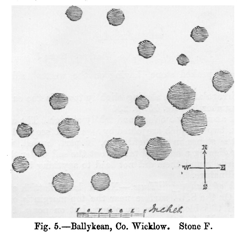
Archaeology & History
This is one of at least fourteen petroglyphs in this parish that have been either lost or destroyed since their initial description in the 19th century. It was described in George Kinihan’s (1884) survey as being, “a small peaked stone, having on the western side two small cups.” The carving has not been seen since then and he seems to have made no sketches of the stone. When the Archaeological Survey of Ireland looked for the carving in 1990 it could not be located.
References:
Corlett, Christiaan, Inscribing the Landscape: The Rock Art of South Leinster, Wordwell: Dublin 2014.
Kinihan, George H., “Proceedings: Cup-marked and Inscribed Stones in the Counties of Wicklow and Wexford”, in Journal Royal Society Antiquaries Ireland, (4th series) volume 6, 1884.
Cup-Marked Stone (lost): OS Grid Reference – SG 21537 42375
Also Known as:
Ballykean ‘Stone F’ (Kinihan 1884)
Archaeology & History
Kinihan’s 1884 rubbing of the stone
This is one of at least fourteen petroglyphs in this parish that have been either lost or destroyed since their initial description in the 19th century. It was described in George Kinihan’s (1884) survey as being, “a slightly dome-shaped stone, its surface being nearly level with that of the ground. The cups are both numerous and deep…although bits of the surface have been flaked off by fire.” He took a rubbing of the stone which showed nineteen cup-marks on its upper surface. When the Archaeological Survey of Ireland looked for the carving in 1990 it could not be located; and when Christiaan Corlett (2014) described this and the other carvings in this cluster, he thought that a group of stones dumped “in a hollow area north of the field” might possibly be where it had been moved to—although no such carvings have been identified there.
References:
Corlett, Christiaan, Inscribing the Landscape: The Rock Art of South Leinster, Wordwell: Dublin 2014.
Kinihan, George H., “Proceedings: Cup-marked and Inscribed Stones in the Counties of Wicklow and Wexford”, in Journal Royal Society Antiquaries Ireland, (4th series) volume 6, 1884.
Cup-Marked Stone (lost): OS Grid Reference – SG 21640 43035
Also Known as:
Ballykean Stone A (Kinihan 1884)
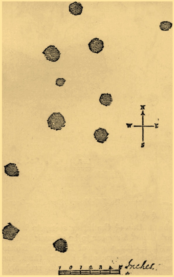
Archaeology & History
Kinihan’s rubbing of the stone
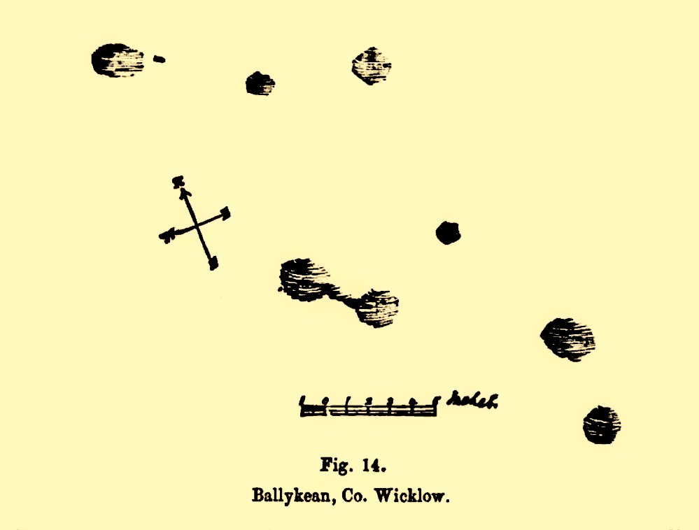
This is one of at least fourteen petroglyphs in this parish that have been either lost or destroyed since their initial description in the 19th century. First noticed by a Mr Hugh Jones of Ballykean House, it was the northernmost carving in the cluster. When the Archaeological Survey of Ireland looked for the carving in 1990 it could not be located—although they did note a stone of similar size in the field boundary to the north-east, but could find no cup-marks on it.
Ballykean (14 ) stone
When George Kinihan (1884) described the stone, he told it to be a block of granite, “about 5 feet by 5.3 feet, and standing 3.3 feet high” in a field known as the Fort Field (although there are no remains of a fort here). Kinihan took a rubbing of the carving, which highlighted eleven cup-marks on its upper surface, as illustrated here. More recently, in Corlett’s (2014) rock art survey, he told that there were “several large dumps of granite boulders” north of the field and wondered whether these might be where this, and the other stones, had been moved. Does anyone know…?
References:
Corlett, Christiaan, Inscribing the Landscape: The Rock Art of South Leinster, Wordwell: Dublin 2014.
Kinihan, George H., “Proceedings: Cup-marked and Inscribed Stones in the Counties of Wicklow and Wexford”, in Journal Royal Society Antiquaries Ireland, (4th series) volume 6, 1884.
Cup-Marked Stone (lost): OS Grid Reference – SG 21584 42230
Also Known as:
Ballykean ‘Stone M’ (Kinihan 1884)
Archaeology & History
Ballykean (2) or “Stone M”
This is one of at least fourteen petroglyphs in this parish that have been either lost or destroyed since their initial description in the 19th century. When the Archaeological Survey of Ireland looked for this carving in 1990, it could not be located. It was first described by George Kinihan (1884), who told that it was, a “block about 6 by 5.5 feet, and 2.25 feet high. The upper surface has eight cups, two of which are joined by a channel.” The site was included in Corlett’s (2014) fine survey, who could add no additional data about the stone.
References:
Corlett, Christiaan, Inscribing the Landscape: The Rock Art of South Leinster, Wordwell: Dublin 2014.
Kinihan, George H., “Proceedings: Cup-marked and Inscribed Stones in the Counties of Wicklow and Wexford”, in Journal Royal Society Antiquaries Ireland, (4th series) volume 6, 1884.
Cup-Marked Stone (lost): OS Grid Reference – SG 21648 42072
Also Known as:
Ballykean ‘Stone N’ (Kinihan 1884)
Archaeology & History
This is one of at least fourteen petroglyphs in this parish that have been either lost or destroyed since their initial description in the 19th century. The carving was, wrote Kinahan (1884) in his day, “in the field south of Ballykean House.” But when the Archaeological Survey of Ireland looked for the stone in 1990, it could not be located. Kinihan told that it was,
“a large flattish stone, which slopes SW. On the SW surface near the top margin is one cup. In the vicinity of this block there are others, but on none of them were cups remarked. Most of these have been split, while others are said to have been broken up to build Ballykean House, with the farm buildings and walls.”
References:
Kinihan, George H., “Proceedings: Cup-marked and Inscribed Stones in the Counties of Wicklow and Wexford”, in Journal Royal Society Antiquaries Ireland, (4th series) volume 6, 1884.
Cup-and-Ring Stone (destroyed): OS Grid Reference – V 838 896
Archaeology & History
o’Connell’s 1939 sketch
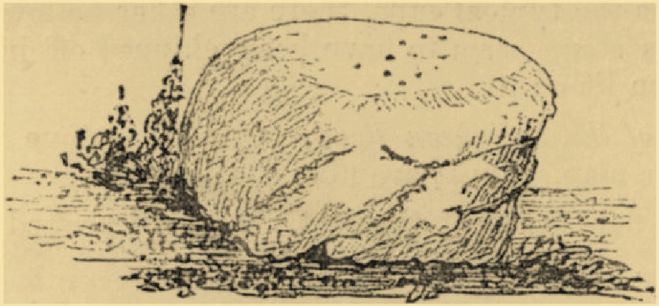
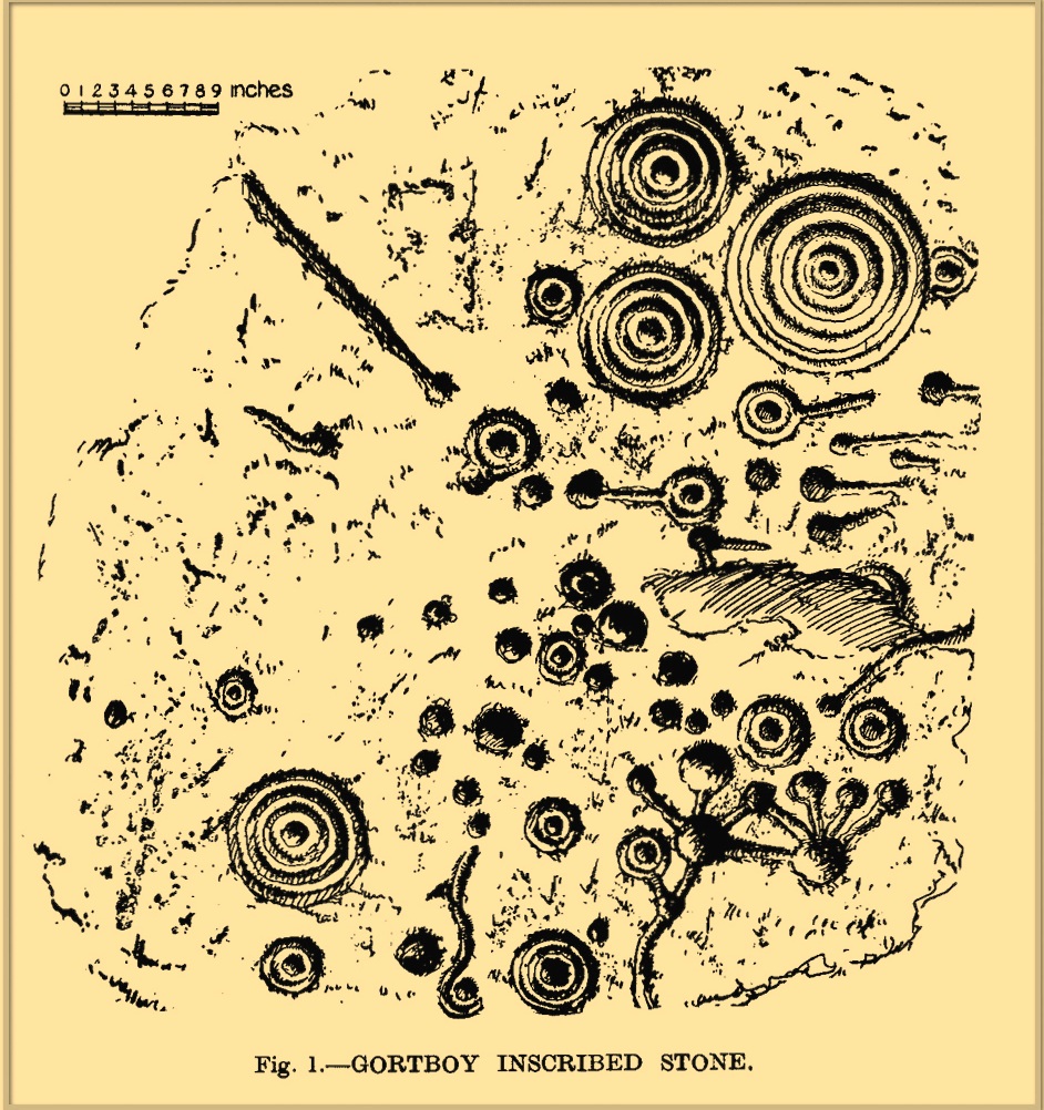
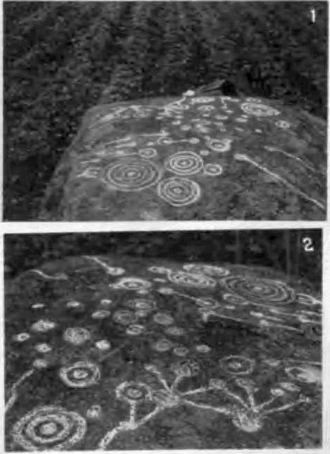
In 1939 when D.B. o’ Connell wrote about this impressive cup-and-ring stone, he told that, with the exception of the Caherlehillan petroglyph (at V 569 837), this was “by far the most extensively decorated stone” that he’d seen in Kerry. He would therefore have been appalled to hear that it was subsequently destroyed in the 1950s and some remaining fragments of the stone “were used to line a well”! (o’ Sullivan & Sheehan 1996) Not good. There had already been an attempt to destroy the stone at the end of the 19th century, but that was prevented. Thankfully we had some early pioneer antiquarians who left us with information and sketches of this once great carving.
It was first described in John Cooke’s (1906) fine essay on the prehistoric antiquities scattering this part of Kerry. According to him, a certain “Dr. Digby is due the credit of having discovered this stone” a few years prior to him writing his essay. He told that:
Cooke’s 1906 sketch
“In one of the fields is a huge boulder, or rather earth-fast rock, somewhat rectangular in shape, of the purple grit of this district, and lying north and south. It measures 7 feet 8 inches long, 5 feet 8 inches broad at the south end, and 4 feet 6 inches at north end, the heights respectively being 2 feet 6 inches, and 2 feet 3 inches. A section from north to south would show a slight curve, as the rock is a few inches higher in the middle than at either end. The greater portion of this massive rock is covered with an extraordinary number of cup-markings, and cups with concentric circles. There are connecting channels everywhere, and the whole, though apparently intricate and unmeaning at first, yet shows, on examination, evidence of intention and design. It is much worn and weathered, and the north end has no markings. It is difficult to take a good rubbing of it, and still more difficult to sketch the markings, as the more it is examined, the more work does it show.”
This last comment applies to many petroglyphs. Mr Cooke continued:
“A peculiar feature of the ornament consists in the groups on the top left-hand corner, not unlike the tentacles and cupules of a cuttlefish. The dumb-bell-shaped ornament is found on other stones, but the truncheon-shaped figures on the right below are, I think, exceptional.”
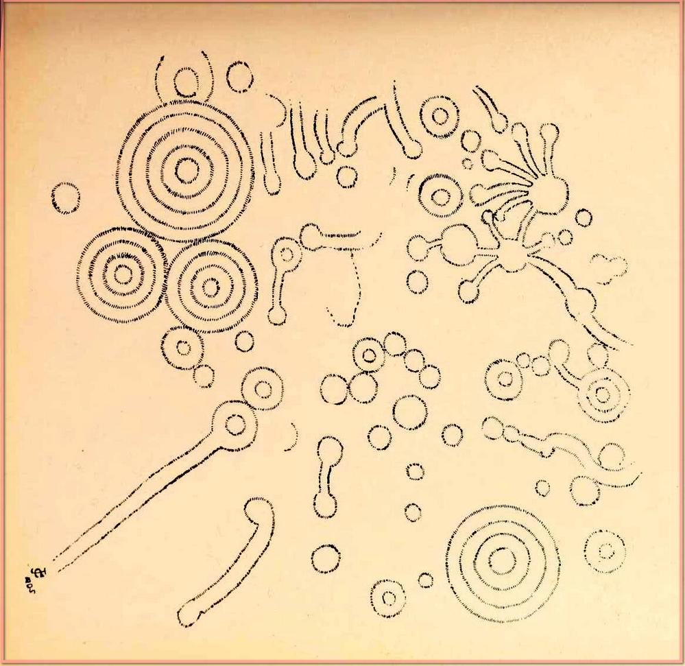
A discrepancy arose a few years later when Miss C. Hussey (1909) told how the carving had been discovered by a certain “Captain Magill, who some years afterwards saved it from destruction.” She told how,
“One day, when shooting in the neighbourhood, he saw some men breaking it with crowbars, etc., merely to clear the field of stones, and his daughter, who first showed it to me, said she believed that before he reached the spot, some four feet or more had been broken off the broader (south) end.”
So whether it was him or Dr Digby, we may never quite know. As for the design, Miss Hussey told us:
Miss Hussey’s sketcho’Connell’s 1939 photos
“The stone itself is a large block of sandstone, some four feet in height, and six feet wide. The entire length at present is nine feet, but the flat carved top only measures seven feet four inches in length, as the northern side slopes gradually instead of being upright like the others. The largest circle on the stone is twelve inches in diameter, and the cups and hollows vary in size down to about an inch across. It was difficult to be certain whether some hollows were cups or merely natural inequalities in the stone, but I have only given those which seemed to be unmistakably the work of man” in this sketch.
In o’ Connell’s (1939) description he echoed what our earlier writers had said, and thankfully gave us a couple of photos of the carving, highlighting the design in chalk so we could see it clearer. It’s such a pity that it’s no longer with us…
References:
Cooke, John, “Antiquarian Remains in the Beaufort District, County Kerry,” in Proceedings of Royal Irish Academy, volume 26, 1906.
Hadingham Evan, Ancient Carvings in Britain: A Mystery, Garnstone: London 1974.
Hussey, C., “Gortbuee Cup and Circle Stone,” in Kerry Archaeological Magazine, volume 1, 1909.
o’ Connell, D.B., “Notes on Three Inscribed Stones in County Kerry,” in Journal Cork Historical & Archaeological Society, volume 44, 1939.
o’ Sullivan, Ann & Sheehan, John, The Iveragh Peninsula: An Archaeological Survey of South Kerry, Cork University Press 1996.
Acknowledgements:Huge thanks for use of the Ordnance Survey map in this site profile, reproduced with the kind permission of the National Library of Scotland.
In o’ Sullivan & Sheehan’s (1996) magnum opus, they reported the discovery of a decent cup-and-ring stone “during road-widening operations in the 1970s,” a short distance west of the river Staigue. It was “seen to have rock art motifs on it, but it has since been covered over.” Its design was apparently similar to a complex carving at found Liss (V 608 617), just 300 yards or so to the south.
References:
o’ Sullivan, Ann & Sheehan, John, The Iveragh Peninsula: An Archaeological Survey of South Kerry, Cork University Press 1996.
Cup-and-Ring Stone (lost): OS Grid Reference – Q 508 001
Archaeology & History
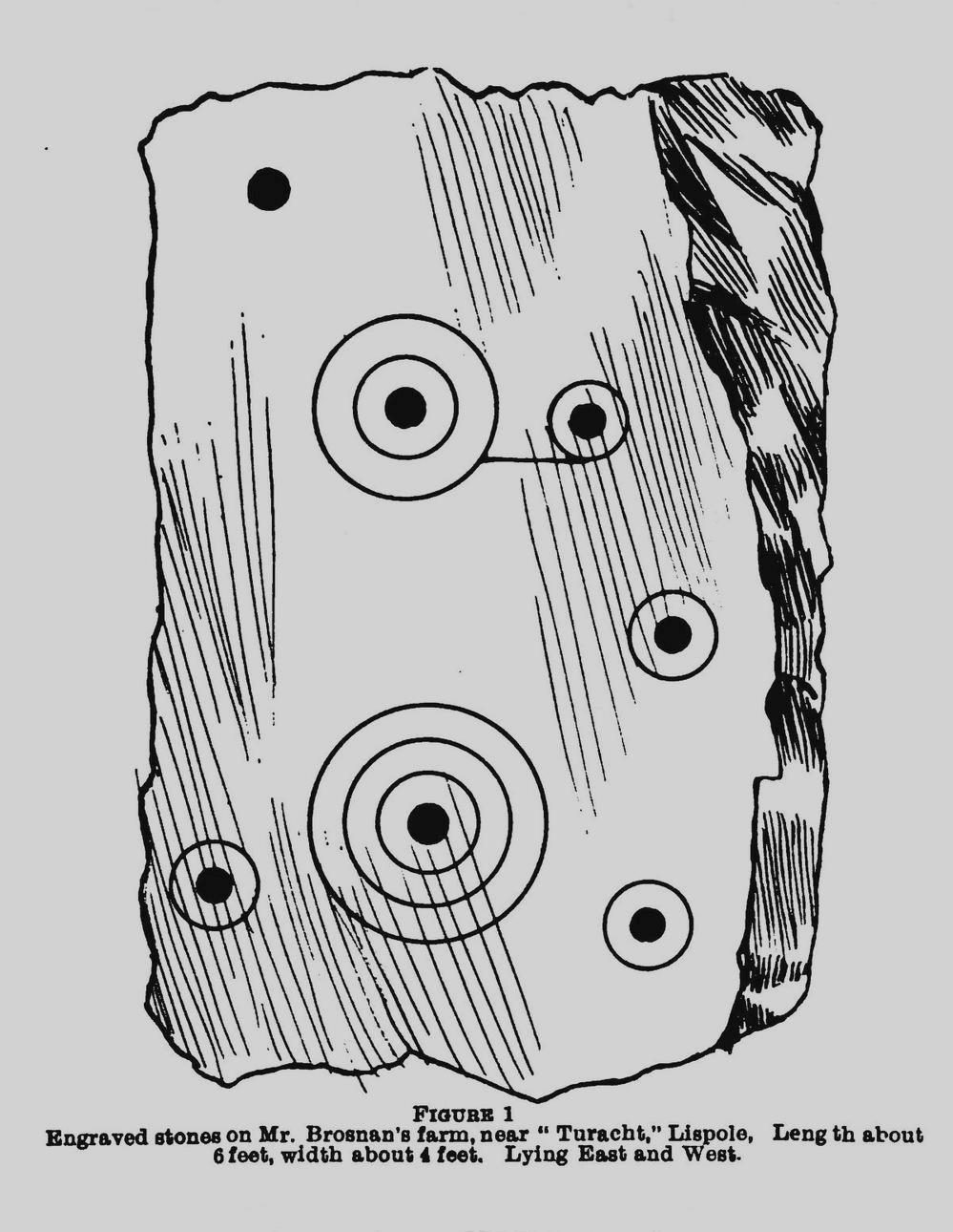
An impressive multiple cup-and-ring stone was discovered near the beginning of the 20th century by Rev. Orpen (1908) who gave a reasonably good description of its whereabouts and, thankfully, a sketch of the basic design. But since his day, it’s not been seen again. He told us that after,
“Leaving the Church of St. Martin, and passing down the main road towards Dingle, we take a turn to the left, and cross the river to the village of Furacht. Here, on the farm of Mr. Brosnan, about 300 yards up the hill towards the south, may be seen a carved stone…marked with cups and concentric circles. The stone is about 6 feet long by 4 feet wide. It was partially covered with sods of grass, which, when they were cleared away, revealed some other cups and circles. This stone lies on one of the ditches running north and south on Mr. Brosnan’s farm.”
The grid-reference given for this site is taken from Judith Cuppage’s (1986) fine survey, who had no success finding it. But a stone of this size shouldn’t be too difficult to locate—unless it’s either covered in vegetation or it’s been destroyed. Do any Lispole or Dingle folk know what’s become of it?
References:
Cuppage, Judith, Archaeological Survey of the Dingle Peninsula, Oidhreacht Chorca Dhuibhne: Ballyferriter 1986.
Orpen, R., “Antiquities near Lispole, Co. Kerry,” in Kerry Archaeological Magazine, volume 1, 1908.
Acknowledgements:Huge thanks for use of the Ordnance Survey map in this site profile, reproduced with the kind permission of the National Library of Scotland.
Cup-and-Ring Stone (lost): OS Grid Reference – Q 58 04
Archaeology & History
Judith Cuppage (1986) reported that in 1953 a Mr Adams of the County Kerry Field Club, when he was checking out two recognised petroglyphs in this locale (Coumduff [1] and [2]), his attention was brought to this, previously unrecognized carving,
“which lay against the bank from which it had previously fallen. It was decorated with numerous cup-marks, at least one of which were enclosed by circles.”
For some reason, Mr Adams didn’t give any good directions as to its whereabouts and as a result, since that day in ’53, it hasn’t been seen since! The likelihood is that it lays somewhere either in-between, or at least pretty close to the other two carvings. If there are any explorers in that neck o’ the woods who might know where it lies sleeping, please let us know so we can bring it back to life, so to speak.
References:
Cuppage, Judith, Archaeological Survey of the Dingle Peninsula, Oidhreacht Chorca Dhuibhne: Ballyferriter 1986.