Legendary Rock: OS Grid Reference – SE 28659 34229
Also Known as:
- Giant’s Stone
Originally located at SE 28449 34364, the site is now to be found halfway along Westfield Road, where it meets up with Hollis Place, along the footpath at the back of the school, set back against the walling. A plaque by the rock kinda gives the game away!
Archaeology & History
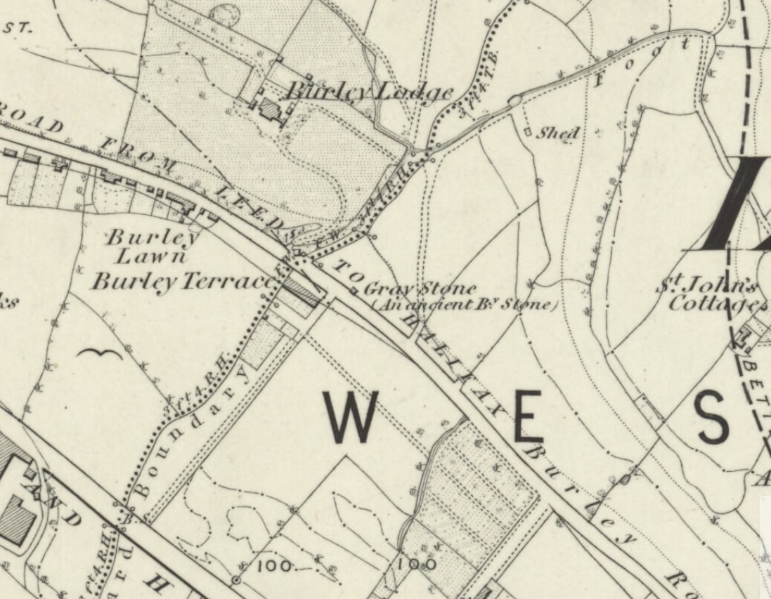
Gray Stone on 1852 map
The large vandalised stone you see here—sprayed-painted quite eloquently it has to be said!—is apparently a replica of the old stone which could once be found about 300 yards northwest of here. Typifying stones of this name—gray, grey and variants thereof—the original Gray Stone was an old boundary marker (Smith 1956), and the last reference to it as an archaeological site was by James Wardell (1853), who even in his day said that it was “almost buried in the ground, on the Burley Road.” It is shown on the first OS-map by the roadside, close to the junction of Woodside View and Burley Road, but was said to have been removed at the beginning of the 20th century and moved to its new and present position. However, somewhere along the line, the original stone has been destroyed and the thing that we see today has taken its place.
The original Gray Stone may have been a standing stone, but we cannot be certain about this. The present boulder stands about four feet tall and is a rather fat-looking standing stone. You can just about squeeze round the back of it, around which is an incised line which cuts around the stone – but this obviously quite modern. A plaque stands in front of the stone, telling its brief history. (if anyone can send us some photos of the site that would be great – I’ve gone and lost mine, somehow!)
Folklore
A creation myth of this site tells it to have been made by a giant, who threw the Gray Stone from the appropriately named Giant’s Hill (a supposed old camp, now destroyed), less than a mile southeast of here: an alignment which corresponds closely to the midsummer sunrise. In throwing it, he was said to have left the indentations of his finger-marks in the rock – thought to have been cup-markings. Examples of other cup-and-ring stones occur a short distance west, at Kirkstall.
References:
- Bennett, Paul, The Old Stones of Elmet, Capall Bann: Milverton 2001.
- Smith, A.H., English Place-Name Elements – 2 volumes, Cambridge University Press 1956.
- Wardell, James, The Antiquities of the Borough of Leeds, John Russell Smith: London 1853.
© Paul Bennett, The Northern Antiquarian