The archaeology and traditions ascribed to this ancient tree (exact position unknown) is based on words that were first penned two hundred years ago. It was thankfully recorded with a reasonable description when William Nimmo wrote about the great Sir William Wallace in the second edition of his Stirlingshire (1817) work. Known about in oral tradition by local people, Nimmo told how:
“Torwood was a place where he and his party, when engaged in any expedition in this part of the country, often held their rendezvous, and to which they retreated in the hour of danger. Here is still to be seen an aged oak, well known by the name of Wallace’s Tree; which seems to have been, even then, rotten and hollow within, and is said to have often afforded a lodging to him and a few of his trusty friends. It is supposed to have been one of the largest trees that ever grew in Scotland. It is now almost quite decayed; but, from its ruins, appears to have been of an uncommon size. The remaining stump is no less than eleven or twelve feet in diameter. It stands upon the summit of a small eminence, which is surrounded on all sides by a swamp. A rugged causeway runs from the south through the swamp, and leads up to the tree. Some other vestiges of the stonework are discernible, surrounding the tree in a circular form, and leading to the conjecture that this oak is of a very high antiquity; and that, having been much frequented by Druidical priests, amongst whom the oak was sacred, the causeway had been laid for their approach to it, and the performance, underneath its branches, of religious rites.”
Nimmo may have a point here. Not necessarily of druids (although druidic traditions and reality is known from many old tracts to have continued in many of the hidden places in Scotland), but certainly in relation to the paved track leading to a what may have been a recognised moot-hill, on top of which this great oak once stood. Great trees and ancient meeting places were held in high esteem, not only in the legends of druidism and more established animistic pantheons, but in the recognised pragmatism of local tribal gatherings, in Scotland, Wales, England and in traditional cultures all over the world. (Gomme 1880) The traces of stonework leading to the hill strongly implies an archaeological site in the paving alone; but moreso, as an important site in the traditions of the Scottish people. The fact that these stone ruins were still visible when Nimmo visited the site in the latter-half of the 18th century in the context he describes, implies it may have been the remains of a possible crannog; or a moot hill; or even, with its great oak surmounting, a sacred grove! In my mind, it was probably being used as a gathering place long before William Wallace and his men gathered here…
In 1880, a 3rd edition of Nimmo’s Stirlingshire was published and edited by R. Gillespie. Herein were additional notes about Wallace’s Oak that had been uncovered by Mr Gillespie. Although he’d visited the place,
“Not the smallest vestige…of the Wallace oak remains. Even the ” oldest inhabitant” can say nothing of it save what he has gathered from tradition. Sir Walter Scott, in his Tales of a Grandfather, speaks of having seen some of its roots eighty years ago; and recently we were shown a treasured morsel of the tree in the Chambers’ Institute at Peebles. Wallace, undoubtedly, often chose the solitude of the Torwood as a place of rest for his army, raised and roused to oppose the tyranny of Edward. Here he concealed his numbers and his designs, sallying out suddenly on the enemy’s garrisons, and retreating as suddenly when afraid of being overpowered. While his army lay in these woods, “the oak” was his head-quarters. Within it, the illustrious hero generally slept, the hollow trunk being huge enough to afford shelter both to himself and one or more of his associates.”
When John Gibson (1908) came to write about it, he told that “Wallace’s Oak, which stood on another part of Woodside (low Torwood), has…vanished.” No roots, no lingering trunk—nothing. But although the tree has long since gone, William M. Stirling pointed out in 1817 that,
“A young tree is pointed out in the neighbourhood, as having sprung from an acorn of Wallace’s Oak.”
If and when we can locate the old toll-house of Broomage at Larbert, we get much closer to identifying the exact location of this long lost oak. Then, perhaps, a commemorative plaque should surely be placed there to remind people of their great history, and included on tours of sites relating to Sir William Wallace.
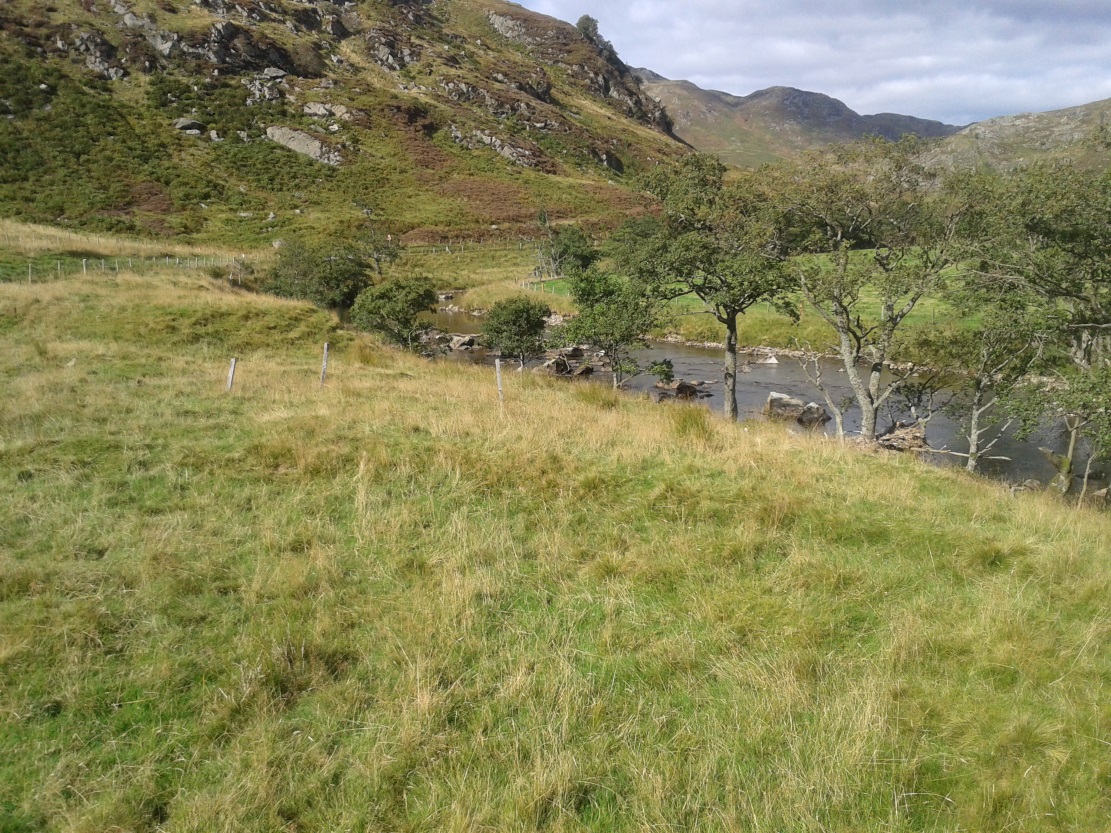
There are two ways into this glen by road. Whichever route you take (from Crieff side, or via the long Dunkeld route), when you hit the flat bottom of it, where the green fields are right by the roadside, walk along till you find the road meets the river’s edge. On the south-side of this small roadside section of the river, you’ll see a single large boulder 10-20 yards away. That’s the spot!
Archaeology & History
Described in some of the archaeology texts as just a ‘cist’, this giant stone is obviously the remains of much more. For a start, as the 1834 drawing illustrates here (coupled with several other early descriptions of the place), other visible antiquarian remains were very much apparent at Ossian’s Stone before a destructive 18th century road-laying operation tore up much of this ancient site. A marauding General Wade of the English establishment was cutting through the Scottish landscape a “military road”, to enable the English to do the usual “civilize the savages”, as they liked to put it. This curious “Giant’s Grave” was very lucky to survive.
Skene’s 1834 sketch, showing surrounding ringOssian’s Stone in the Sma’ Glen
The earliest description of events surrounding the site, as well as the attitude of the Highlanders when they saw the disrespectful English impose their usual disregard, is most insightful. In a series of letters written by a Captain Edward Burt (1759) in the first-half of the 18th century to the english monarch of the period, we read a quite fascinating account which must have been very intriguing to witness first-hand.
General Wade and his band of marauders had reached the Sma’ Glen at the end of Glen Almond and were about to continue the construction of their road. Burt (1759) wrote:
“A small part of the way through this glen having been marked out by two rows of camp colours, placed at a good distance one from another, whereby to describe the line of the intended breadth and regularity of the road by the eye, there happened to lie directly in the way an exceedingly large stone; and, as it had been made a rule from the beginning, to carry on the roads in straight lines as far as the way would permit, not only to give them a better air, but to shorten the passenger’s journey, it was resolved the stone should be removed, if possible, though otherwise the work might have been carried along on either side of it.
“The soldiers, by vast labour, with their levers and jacks, or hand-screws, tumbled it over and over till they got it quite out of the way, although it was of such an enormous size that it might be matter of great wonder how it could ever be removed by human strength and art, especially to such who had never seen an operation of that kind: and, upon their digging a little way into that part of the ground where the centre of the base had stood, there was found a small cavity, about two feet square, which was guarded from the outward earth at the bottom, top, and sides, by square flat stones.
“This hollow contained some ashes, scraps of bones, and half-burnt ends of stalks of heath; which last we concluded to be a small remnant of a funeral pile. Upon the whole, I think there is no room to doubt but it was the urn of some considerable Roman officer, and the best of the kind that could be provided in their military circumstances; and that it was so seems plainly to appear from its vicinity to the Roman camp, the engines that must have been employed to remove that vast piece of a rock, and the unlikeliness it should, or could, have ever been done by the natives of the country. But certainly the design was, to preserve those remains from the injuries of rains and melting snows, and to prevent their being profaned by the sacrilegious hands of those they call Barbarians, for that reproachful name, you know, they gave to the people of almost all nations but their own.
“…As I returned the same way from the Lowlands, I found the officer, with his party of working soldiers, not far from the stone, and asked him what was become of the urn? To this he answered, that he had intended to preserve it in the condition I left it, till the commander-in-chief had seen it, as a curiosity, but that it was not in his power so to do; for soon after the discovery was known to the Highlanders, they assembled from distant parts, and having formed themselves into a body, they carefully gathered up the relics, and marched with them, in solemn procession, to a new place of burial, and there discharged their fire-arms over the grave, as supposing the deceased had been a military officer.
“You will believe the recital of all this ceremony led me to ask the reason of such homage done to the ashes of a person supposed to have been dead almost two thousand years. It did so; and the officer, who was himself a native of the Hills, told me that they (the Highlanders) firmly believe that if a dead body should be known to lie above ground, or be disinterred by malice, or the accidents of torrents of water, &c. and care was not immediately taken to perform to it the proper rites, then there would arise such storms and tempests as would destroy their corn, blow away their huts, and all sorts of other mis-fortunes would follow till that duty was performed. You may here recollect what I told you so long ago, of the great regard the Highlanders have for the remains of their dead…”
Ossian’s Stone in his landscape
We can rest assured that the ‘Roman officer’ idea proclaimed by our early narrator is most probably wrong and that the nature of this site, when seen at ground-level even today and moreso by referencing Skene’s 1834 drawing of the place, above (which shows a more complete low surrounding ring of stones) indicate this to be of prehistoric provenance. Of intrigue to me, is the ritual of the incoming Highlanders, who took the relics onto another place and re-interred them in their own customary manner. We do not know where the Highlanders moved these (probable) prehistoric relics and I can find no supporting folklore to show precisely where they went—but a likely site would be the prehistoric cairn on the mountaintop southwest of here (at NN 8899 3018), or a site that has sometimes been confused with Ossian’s Stone a short distance to the south in the Sma’ Glen, known as the Giant’s Grave (at NN 9050 2956). This latter site would seem more probable.
Anyway…. many years after Edward Burt’s initial Letters defined the site for outsiders, one Thomas Newte (1791) came a-wandering hereby. He found that the account of General Wade’s intrusion was still on the tongues of local people, along with additions of further giant-lore and Fingalian tales, typical of the Creation myths of our early ancestors. In typically depreciative English manner Newte told:
“In that awful part of Glen Almon, already mentioned, where lofty and impending cliffs on either hand make a solemn and almost perpetual gloom, is found Clachan-Of-Fian, or monumental Stone of Ossian. It is of uncommon size, measuring seven feet and an half in length, and five feet in breadth. About fifty years ago, certain soldiers, employed under General Wade in making the Military Road from Stirling to Inverness, through the Highlands, raised the stone by large engines, and discovered under it a coffin full of burntbones. This coffin consisted of four gray stones, which still remain, such as are mentioned in Ossian’s Poems. Ossian’s Stone, with the four gray stones in which his bones are said to have been deposited, are surrounded by a circular dyke, two hundred feet in circumference, and three feet in height. The Military Road passes through its centre.”
Cole’s 1911 plan of stone & surrounding ringOssian Stone by Fred Cole
From hereon, many other writers and travellers came to see this great legendary stone within the depleted remains of its embanked circle—and thankfully it hasn’t been disturbed any further, still being visible to this day. The greatest ‘archaeological’ attention the site has received was from the early pen of great antiquarian Fred Coles (1911). On his journey here, after travelling past a large white stone which was mistakenly named as Ossian’s Stone by the usual contenders, he and his friend reached the right place:
“close to a strip of ground where the river and road almost touch each other, and immediately below the steepest of the crags of Dun More on the eastern side and the debris slopes of Meall Tarsuinn on the west, a most impressive environment, be the stone a prehistoric monument or not! The spot is interesting for itself, apart from all legend; and the remains consist of a mighty monolith…and a narrow grassy mound…to its east, with a few earthfast blocks set edgewise near its eastern extremity. Close to the roadside, but at the same level of 690 feet above the sea, there is a slab-like stone set up, measuring 3 feet in width, 1 foot 3 inches in thickness, and about 2 feet 6 inches in height. A space of 63 feet separates this block…from the huge rhomboidal mass called Ossian’s Stone. Five feet east of the latter is the base of the grassy mound which measures about 12 feet in length, 4 feet in greatest breadth, and 3 feet 10 inches in height. To the north and the south in a slightly curving line are set the six small slabs shown. There seems also to be a vague continuation of this strange alignment in both directions. All over the ground between A and B, are many strangle low parallel ridges of smallish stones having a general direction of nearly north and south. The rest of the ground is grassy, and here and there a little stony. In the plan all the stones are drawn larger than exactly to scale.
“The great stone is 8 feet high and has a basal girth of 27 feet. Several small stones lie near it. Such are the facts as at present to be observed on the ground.”
Section of outlying grass-covered low ring, just visibleGeological cup-marks?
There are two small conjoined cup-marks on top of the stone, but these seem to be geological in nature. The precise nature of the site is difficult to ascertain without excavation; but the Royal Commission lads reckon it to be a prehistoric ‘cist’ or grave in their own analysis, based mainly on the quoted literary texts. The surrounding ‘ring’ of small stones doesn’t seem to have captured their attention too much; but the site needs contextualizing within this damaged circular enclosure, which appears to have been a cairn circle initially, of some sort, with Ossian’s huge stone resting over the grave of one late great ancestral character, probably placed here thousands of years back in the Bronze Age… A truly fascinating place in truly gorgeous landscape.
Folklore
The glen itself has a scattering of giant lore associated with Finn and/or Ossian. A nearby cave was one of the places where this legendary character, and subsequent bards, were said to have spent time.
There are a small number of heavy rocks presently placed on top of Ossian’s Stone. These may be due to the site being used as a “lifting stone”: a sort of rite of passage found at a number of sites in the Perthshire mountains and across the Highlands to indicate a boy’s strength before entering manhood. Not until they have lifted and deposited a very heavy rock onto the boulder can they rightly become chief or leader, etc.
The poet William Wordsworth wrote about Ossian’s Stone, calling it “Glen Almein, or The Narrow Glen”:
In this still place, remote from men,
Sleeps Ossian, in the Narrow Glen;
In this still place, where murmurs on
But one meek streamlet, only one:
He sang of battles, and the breath
Of stormy war, and violent death;
And should, methinks, when all was past,
Have rightfully been laid at last
Where rocks were rudely heaped, and rent
As by a spirit turbulent;
Where sights were rough, and sounds were wild,
And everything unreconciled;
In some complaining, dim retreat,
For fear and melancholy meet;
But this is calm; there cannot be
A more entire tranquillity.
Does then the Bard sleep here indeed?
Or is it but a groundless creed?
What matters it? I blame them not
Whose Fancy in this lonely Spot
Was moved; and in such way expressed
Their notion of its perfect rest.
A convent, even a hermit’s cell,
Would break the silence of this Dell:
It is not quiet, is not ease;
But something deeper far than these:
The separation that is here
Is of the grave; and of austere
Yet happy feelings of the dead:
And, therefore, was it rightly said
That Ossian, last of all his race!
Lies buried in this lonely place.
References:
Anonymous, Tourists Guide to Crieff, Comrie and the Vale of Strathearn, Crieff
1874.
Tumulus (destroyed): OS Grid Reference — NT 237 861
Archaeology & History
Very little is known about a prehistoric tomb that once existed near the coast at Craigkennockie. Its existence was briefly described in Andrew Young’s (1913) fine history of the township where he told that it had been highlighted on an old Estate Map of the area and marked as, “an artificial cairn, probably a place of sepulture.” On old maps just below the cited place we find the place-name of ‘Lammerlaws’, which may indicate a name once given to the site, as the element -law is commonly found relating to prehistoric cairns.
Although the modern place-name researchers in central Scotland have opted that the word ‘law’ is primarily “a rounded hill”, they have curiously forgotten or omitted its other derivation. Throughout northern England and beyond, the English Place-Name Society finds that many ‘law’ place-names derive from the old English and Saxon word, hlaw, which is originally told to be “a mound, a hill.” This has been the reference cited throughout in Taylor & Markus’ (2006-2012) otherwise fine multi-volume analysis of Fife county. But there’s much more to it than that. I hope that readers will forgive me reciting A.H. Smith’s (1956) full entry about this simple term, as it can (and many times does) show our history is much richer than initially thought. Prof Smith told that law, hlaw, hlæw, has the following etymological origin:
“(1) In OE (old English) the common meaning in literary contexts is ‘an artificial mound, a burial mound, a mound in which treasure is hidden’, as in Boethius Metr. 10.43, ‘in what hlæwa do the bones of Weland cover the ground?; Beowulf 2802, ‘Bid them make a hlæaw…on Hronesnæsse’; Guthlac 4 ‘there on the island was made a great hlæw, which through the lust for treasure had been dug up and broken into’; or Gnomic Verses 26, ‘a dragon shall be on hlæw’, an allusion (as in Beowulf 2773) to the Germanic tradition that mounds containing valuable grave-goods were guarded by dragons. The word glosses Latin, agger, ‘something heaped up, a mound, a rampart’ (Wright’s Anglo-Saxon & Old English Vocabularies 355.4). This meaning ‘tumulus, artificial mound, burial mound’ is well attested in place-names. According to Grundy, it always denotes a tumulus in the OE charters and doubtless those place-names in which it is combined with personal names are the burial places of the men so named; at Taplow at least a remarkable burial treasure was discovered and Cuckhamsley, Berkshire, is named from Cwichelm, the West Saxon king who died in 593. The majority of such places-names belong to the heathen period when this method of disposing of the dead was practised. Particular compounds also suggest that it could be an artificial mound which formed the centre of a place of assembly; Oswaldslow Hundred (Place-names of Worcestershire, 87), for example, was created in 964 and it was to meet at a place to be henceforth called Oswaldeslaw in honour of Bishop Oswald (Cartularium Saxonica 1135).
“(2) The meaning ‘hill, a conical hill resembling a tumulus’ is also found in OE, as in Leechdoms Vol.3, 52, ‘they rode over the hlæw’, and local topography establishes this meaning as a common one in place-names and dialects in certain parts of the country; it survives as law in Durham and Northumberland and as low in northwest Midlands…
“(3) The two forms hlaw and hlæw are on record, the latter being better evidenced in literary use, especially in West Saxon texts, and the former in place-names; hlæw normally becomes low, north country law, whilst the i-mutated hlæw (found in place-names only in the south and south Midlands) later becomes lew, as in Lew, Oxfordshire, Lewes, Sussex and is more frequent in middle-english spellings; it is often later replaced by –low as in Dragley, Lancs, Cuckhamsley, Berkshire…”
Smith continues with many topographical evidences regarding a ‘burial-mound’ derivation for the place-name ‘law’, finally adding notes on relative linguistic similarities, like the “Gothic hlaiw, ‘grave’; old High German hleo, ‘grave mound, hill’; old Saxon hleo, ‘grave mound’…” It seems pretty convincing, and so we need to take this into account in our walks over the hills if we are exploring ancient history.
As if to emphasize this derivation—’law’ as prehistoric tombs—we find it is cited in the massive Scottish National Dictionary (6,1:16) where—alongside the ’rounded hill’ aspect—Mr Grant (1962) tells it to be,
“An artificial mound or hillock, specif.: (1) a tumlus or barrow, grave-mound….”
thereafter giving a number of Scottish examples. The same meaning is echoed again in the modern version of Concise Scots Dictionary (2005), along with the rounded-hill. Jamieson’s (1885) Scottish Dictionary cites similarly, ‘law’ as both hill, aswell as “a tomb, grave or mound.”
This association of ‘law’ with ancient burial mounds in Scotland should not be that surprising. Despite it having an Anglo-Saxon origin, we must remember that the Saxon kingdom is known to have stretched all the way up to the Firth of Forth (Edinburgh) and across to Glasgow. So if the linguistic roots have any credibility at all, it doesn’t take much stretch of the imagination to have this simple word travel further north amongst the people. Perhaps this is why, more recently, Margaret Gelling (2000) has said that the association of hlaw with burial mounds up here lessens in Scotland. Nonetheless, let us not presuppose one meaningful definition of the word above another, as it can, consciously or otherwise, be seen as more symptomatic of the all too common English attitude of papering over another country’s rich and ancient heritage by depleting its language—again…
(Law has another element attached which has all but fallen out of historical analysis. Prof Smith touched briefly upon it, mentioning ‘law’ as being a meeting place—otherwise known ‘moots’. Moots occurred everywhere in early times: in England, in Europe and in Scotland too. They were originally where local tribal gatherings took place, for the purpose of what we might call council or political decisions, amongst other things. Some of these moots occurred on burial mounds of great age, aswell as stone circles—and evidence indicates that some of them originated way back in prehistoric times. Although written accounts of many such moot spots have fallen from historical texts, the term law or low (and their variants) is again found in Scottish etymological and topographical lore. Mr Grant again cites it to mean:
“Law cairns, or court cairns…the judicial sites of baronial court of justice…”
Thereafter giving numerous citations of its use in both the common tongue and sites where it is known. As far north as the Shetland Isles, where such law-courts aer known from the Scandinavian ting of thing, the 18th century Statistical Account of Tingwall states there being “the Law Stone” at the cite of the parish court.)
Folklore
Also in Mr Young’s (1913) work, he told how this old tomb was a place that seemed cursed or should not be disturbed, saying,
“About 50 years ago, any illness in the neighbourhood of Craigholm was ascribed to the influence of this burial place…”
adding that an adjacent spring of water, of high esteem, was close by.
References:
Grant, William (ed.), Scottish National Dictionary – volume 6, SNDA: Edinburgh 1962.
Jamieson, John, Etymological Dictionary of the Scottish Language, W.P. Nimmo: Edinburgh 1885.
Robinson, Mairi (ed.), Concise Scots Dictionary, Aberdeen University Press 2005.
Smith, A.H., English Place-Name Elements – volume 1, Cambridge University Press 1956
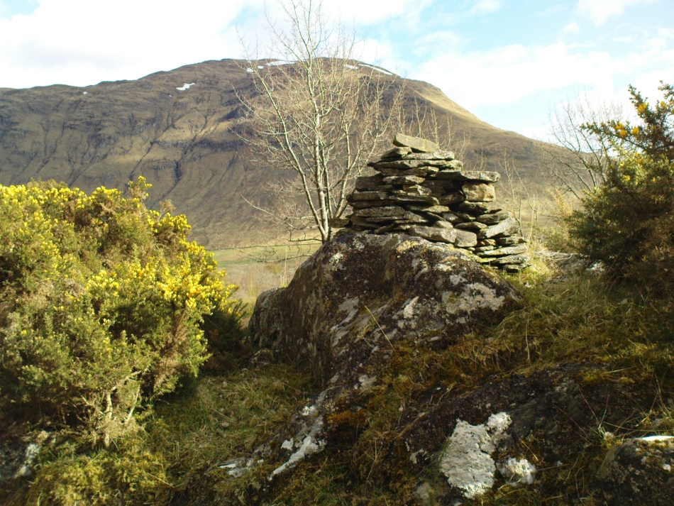
From Fortingall, get to the standing stone of Adamnan’s Cross a few miles down the stunning Glen Lyon. Barely 100 yards before you reach the stone, notice the overgrown gorse-covered rocky rise across the road, just past Craigianie Farm. As you climb to the top of this small rocky rise, you’ll see a cairn of stones on its top. Just below it, into the solid rock, you’ll see a footprint-shaped hollow etched into the stone. If it seems hidden, just keep looking – you’ll find it…
Archaeology & History
St. Palladius Stone, Glen Lyon
When Ratcliffe Barnatt (1944) visited Glen Lyon in the 1940s, this legendary rock was one of his stopping points. “When we have passed by Ruskich and Slatich,” he wrote, “we come to that sacred spot, Craig Dianaidh, the Rock of Safety, where, until about 1480, solemn and judicial meetings were held.” The old rock was known through recent ages, “as a preaching hill, a motehill and a justiciary court,” said Hilary Wheater (1981), and upon its top is the curious ‘footprint’ which Nature’s blood would fill on all but the hottest of summers. It is this geological feature that gave the stone is name, long ago.
Of known historical events here, Wheater further told:
“It was on this rock…that the Baron Courts of Glenlyon were held. Law and order was kept by regular courts held by the Chief or Landowner. The Baron-Bailiary of each area was appointed by Royal Charter. Fifteen men were chosen as a jury and the laird or his baile presided. To this court were brought all the problems and grievances of the people. Here the miller accused several men of refusing to take part in the compulsory ‘hamganging’ of a new millstone; here a man was fined for brewing ale without a license; here a neighbour was accused of putting the ‘evil eye’ on the cow of the croft next door so it produced no milk; and here a man was prosecuted for ‘taking of ane sore horse of his to Rannoch in the summer of 1629 and putting on him ane great burder of timber, and letting him go through the wood where he stuck between two trees all night and the timber on his back.’ However, he was acquitted when he was able to prove that the horse was fit enough after this for another man to be able to take it to Edinburgh soon after.”
St Palladius Footprint
As well as being a moot site, it is more than probable that this footprint, like the one near the top of Dunadd in Argyll—and others scattering the Highlands and beyond—was an initiation stone, perhaps for local tribal elders or ancient kings. Janet Bord (2004) writes about them as places of ritual inauguration in her survey of such places.
Folklore
The legendary site, looking south
This legendary rock would probably have had earlier mythic association than the one ascribing it to St. Palladius—but as yet I have found no written lore telling the nature of such a spirit, so would only perhaps discern the original genius loci by lengthy encounters with the rock in question, through mist and storm and wintry months, alone. It is known in local folklore that Palladius was in fact an urisk: a solitary spirit of steep streams that few humans encounter due to their lonely habits amidst hidden abodes in dark and ancient gorges. Such urisks dwelt in numbers amongst many of the steep falls in this landscape — and still do, if the words of old locals are to be believed. Here,
“St Palladius was a goblin saint, an urisk that dwelt in a mountain burn and was sanctified by the people.”
…and some rocks by the stream up the mountain immediately above this “footprint” was one of the places the urisk was known to dwell.
…to be continued…
References:
Barnatt, T. Ratcliffe, The Road to Rannoch and the Summer Isles, John Grant: Edinburgh 1944.
Bord, Janet, Footprints in Stone, Heart of Albion Press 2004.
Fraser, Duncan, Highland Perthshire, Standard Press: Montrose 1969.
Wheater, Hilary, Aberfeldy to Glenlyon, Appin Publications: Aberfeldy 1981.
There are two large boulders here, one of which was deemed the Ashlar many moons back. You can approach it from the lazy way: park y’ car at the top of the road by the Whetstone Gate TV masts and walk east right along the boundary path till you get here. The better way is from Twelve Apostles: from there walk a coupla hundred yards north to the Lanshaw Lad boundary stone, where a small path heads west. Along here for another coupla hundred yards, then hit the footpath south for the roughly the same distance again. You’ve arrived!
Archaeology & History
The Ashlar Chair is ascribed in folklore, said Harry Speight (1892), “to be a relic of druidism,” as one of its titles in ages past was the Druid’s Chair. In the nineteenth century it also became known as the Etching Stone, (Smith 1961-63) but it has retained its present title for more than two hundred years. Shaped more like a couch than a chair, its present title—the Ashlar—is important in ritual Freemasonry, which has two aspects to it: the ‘rough’ and the ‘perfect’. The first represents the neophyte; the latter, the illumined one. Oaths are sworn on the ashlar, and laws are spoken from it. In its higher aspect it is representative of the spiritual maturity of evolved man.
Ashlar Chair on 1851 map
Although there are no public records as to who gave the site its present name, the land which lays before it, The Square, is an even greater indicator that this rock was was considerably more than just a curious place-name, for the open moorland that is overseen from Ashlar Chair—The Square — is 396,000 square yards of flat open heathlands that have never been archaeologically explored. The Square is also one of the most important elements of Freemasonry: representing the manifest universe, its laws are spoken from the Ashlar. (Jones 1950)
Between the two of them, represented here in the landscape near the very tops of these moors, we have a form of late geomancy, although the names of our geomancers are nowhere to be found. It is obvious though, simply from the name of the land, that dramatic ritual of some form was enacted here. In recent times, ritual magickians from differing Orders have found the place most effective, as have wiccan folk and other pagans who have frequented it at the summer solstice. The possibility that some members of the Grand Lodge of ALL England (a legendary Masonic Order, said by the modern London masons not to have existed until the eighteenth century) gave this place its name is not unreasonable. Records show that in the fourteenth century at least one member of the Order, Sir Walter Hawksworth, frequented ritual circles on these moors; and another member of the same Lodge from the nearby Washburn valley was an ally to the Pendle and Washburn witches who, we know, met on these moors at Twelve Apostles stone circle and probably the Ashlar. But it proves nothing I suppose. (I tend to believe (not a necessarily healthy viewpoint) that the Grand Lodge did use the Ashlar as one of their moot points, along with the Pendle and Washburn witches.)
Its primary geomantic attribute is as an omphalos. Geographically the Ashlar Chair is the meeting-point of Bingley, Burley, Morton and Ilkley moors and, metaphorically speaking, when you stand here you are outside the confines of the four worlds yet still a purveyor of them.
Nature’s cups-and-grooves on the Ashlar
Upon the large rock itself it are carved the faint initials, “MM, BTP, ISP and IG, 1826.” Several early records described cup-and-ring designs on the Ashlar: firstly in Forrest & Grainge’s (1868) archaeological tour; then in Collyer & Turner’s Ilkley (1885); and lastly by the great Yorkshire historian and topographer Harry Speight (1892, 1900), who said “it bears numerous cups and channels.” Although we can see some of these on top of the Ashlar, they are mainly Nature’s handiwork. It is possible that some man-made cup-and-rings once existed on the rock, but if so they have eroded over time.
References:
Bennett, Paul, The Old Stones of Elmet, Capall Bann: Milverton 2001.
Collyer, Robert & Turner, J.H., Ilkley Ancient & Modern, William Walker: Leeds 1885.
Forrest, C. & Grainge, William, A Ramble on Rumbald’s Moor, among the Dwellings, Cairns and Circles of the Ancient Britons in the Summer of 1867 – Part 1, W.T. Lamb: Wakefield 1868.
Jones, Bernard E., Freemason’s Guide and Compendium, Harrap: London 1950.
Speight, Harry, Chronicles & Stories of Old Bingley and District, Elliott Stock: London 1892.
Speight, Harry, Upper Wharfedale, Elliott Stock: London 1900.
From near the middle of the large village (or small town!) of High Bentham, go down Station Road, over the river — where the road becomes known as Thickrash Brow! — and keep going for about a mile. The landscape opens up into the hills and there, on the left-hand side of the road, is a car-parking spot with a footpath taking you straight up to the large boulder a 100 yards on: that’s our Great Stone! You can’t really miss it.
Archaeology & History
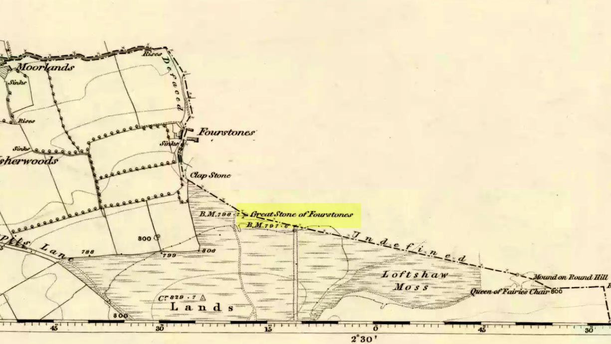
Great Stone on 1847 map
A meeting place of local tribes in more ancient days, the moorland plain upon which the Great Stone sits, beckons to a vast landscape on all quarters (north, south, east and west) calling the elders from their lands for annual rites and decisions to befit the health of the land and the people. The stone rests on the ancient boundary of Yorkshire and Lancashire, just on the Yorkshire side, and was visited annually in more later centuries during the beating of the bounds, to define the edges of the local township.
Graffiti & cup-marks on the top
First described in a Yorkshire inquisition account from 1307, this Big Stone was visited by Harry Speight (1892) who described it as measuring 30 feet round and 12 feet high. I came here for the first time in the 1980s when I was hitch-hiking into the Scottish mountains, but a good old “local” (from the Yorkshire side) took a detour to show me the place! Once here, I climbed up the very worn “steps” which were carved into the side of the boulder several centuries back and it didn’t surprise me to find a number of cup-markings (no discernible rings) on its top surface. When I came here again with Michala Potts and Paul Hornby yesterday, I couldn’t believe how many people had carved their names on top of the Great Stone in the intervening years — it’s almost covered in modern graffiti and the old cup-markings were much harder to see. Taylor (1906) mentions them briefly in his holy wells survey, saying how,
“This great boulder is ascended on its eastern side by fourteen steps, and on the top are two circular holes about two inches deep and two inches in diameter.”
There used to be three others boulders very close to this one (hence its title), making a natural stone circle, but they were “broken up for sharpening scythes” a couple of hundred years back. A much wider archaeological survey of this region is long overdue.
Folklore
Great Stone, looking east
Harry Speight (1892) told how the (original) Four Stones were the creation of our old friend the Devil, long ago, who dropped them in one his many megalithic travels across our land. The stones were also the meeting place of ancient councils, from the tribes either side of the Yorkshire-Lancashire border. Their presence here also had mythic relationship with the Queen of the Fairies Chair, about a mile southeast, along the same boundary line.
Weird how folklore changes. Whilst old Mr Speight told how the devil created the once great four stones that were here, many years later Jessica Lofthouse (1976) told how the three missing stones – which had been here “since the world began” – were actually taken from here by Old Nick. Carrying them over the land,
“His load he dropped on Casterton Fell, where the rocks he discarded, the Devil’s Apronful, are still lying around. He selected the most suitable, dressed them and carried them in panniers down to the (River) Lune”
— and built the legendary Devil’s Bridge at Kirkby Lonsdale – which itself has strange tales to tell. Another creation myth about the Great Stone is told on the plaque near the stone, alongside the footpath, which tells:
“Legend has it that it is a small part of the debris hurled by the giant Finn McCool across the Irish Sea in a fit of anger.”
It’s very obvious that a lotta mythic landscape material has been neglected and overlooked around this site. Something we need to remedy, if we can, in the coming years…
References:
Lofthouse, J., North Country Folklore, Hale: London 1976.
Speight, Harry, The Craven and Northwest Yorkshire Highlands, Elliott Stock: London 1892.
Taylor, Henry, The Ancient Crosses and Holy Wells of Lancashire, Sherratt & Hughes: Manchester 1906.
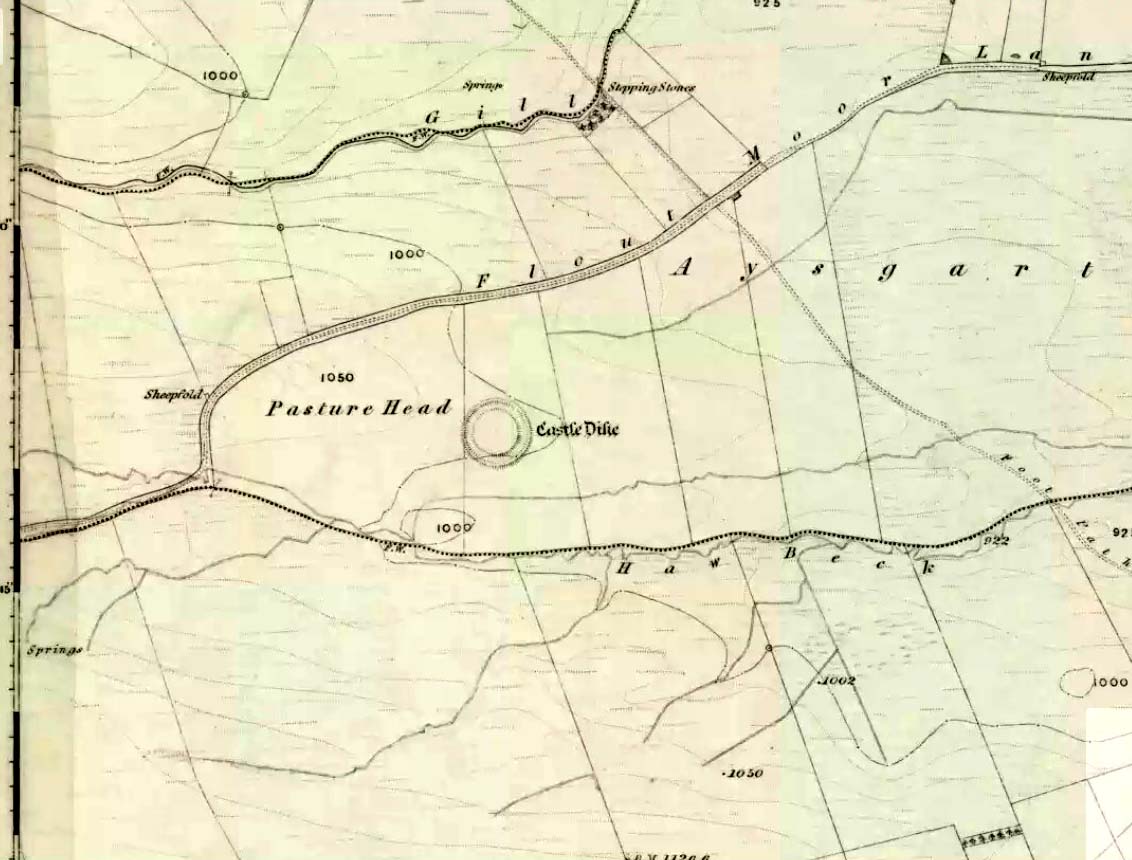
Go west through Aysgarth village along the A684 road and, just as you’re coming out of the town, take the left turn on the Thornton Rust road, past Town Head Farm, and turn left up the track (called Folly Lane). Go past the house where the track veers to your right and follow it straight on (don’t turn up the track on your left a short distance along). Keep walking on here for nearly a mile (about 10 mins), keeping your eyes peeled for the embanked rise in the field on your left, which is where the henge can be found! You’re damn close!
Archaeology & History
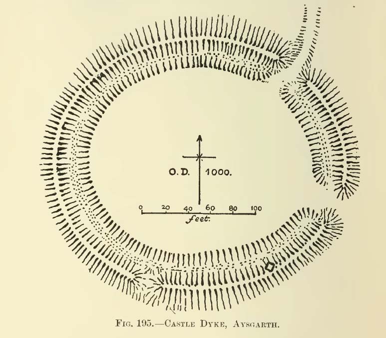
A.H. Allcroft’s 1908 plan
One of the earliest accounts I’ve found describing the Castle Dykes henge is in Mr Barker’s (1854) lovely literary exploration of Wensleydale, where he describes, “on Aysgarth Moor, which is now enclosed, may be seen a circular encampment, probably Danish” in origin. But he tells no more. When Edmund Bogg (c.1906) came here fifty years later, he added little extra, simply telling of, “the earthworks known as ‘Castle Dykes’, probably Angle or Danish, although Roman relics have been found here.” However, the brilliant Mr Speight (1897) gave what seems to be the earliest real description of the site when he described “the Celts” and the earliest settlers of the region, saying how:
“The so-called ‘Castle Dykes’ at Aysgarth betrays a probable connection with the same settlers. It is an irregular circular rampart, measuring about forty yards across its longest diameter, and not unlike the earthwork on Harkaside called ‘Maiden Castle’… A ditch completely encloses the mound, which, it should be noted, is unusually low, being little higher than the outer bank or upcast from the trench. It is totally different from the elaborate burh at Middleham; indeed, from its low and simply form, as well as from its situation in Celtic territory, there seems little doubt that it was the work of these early people.”
Ditch of Castle Dykes henge, looking east (photo credit – Richard Stroud)
Speight also made a suggestion that the place-name of Aysgarth itself may derive from this monument. He may have a point. A.H. Smith (1928) and other place-name authorities tell the name to derive from “an open space” either surrounded by, or — in some way — defined by oak trees. We might never know for sure…
Not long after the works of Speight and Bogg came the first real survey of British prehistoric earthworks by A.H. Allcroft (1908) — and amidst the mass of archaeological curiosities (as many were at the time) was another description of this great ceremonial monument. Allcroft told that here,
“a weak vallum of earth encloses a perfectly regular oval area measuring from crest to crest of the vallum 257 feet (east to west) by 217 feet (north to south). Immediately within the vallum is a broad fosse varying from 25 to 32 feet in width. The vallum at its highest (east) rises not more than seven feet above the floor of the fosse. The “island” measures 196 by 160 feet and is perfectly flat. There is no berm and no outer fosse. The vallum is broken by three gaps, of which that to the southeast is apparently original, as the fosse has never been excavated across it. The other gaps point respectively northeast and south-southwest, the latter being a mere depression like that to be seen at the eastern side of the northern ring at Thornborough. At one point in the vallum, on the southeast, a single large stone rises slightly above the turf which otherwise covers the whole work, and certain depressions observable at other points suggest that other such blocks have been removed —that, in fact, it originally had a peristalith standing upon the vallum. The principal entrance looks towards Pen Hill…”
Around the same time, the early scientific discipline of astroarchaeology was taking root and in Sir Norman Lockyer’s Nature journal, the reverend J. Griffith (1908) explored the potential astronomical orientation of Aysgarth’s Castle Dykes, thinking that the main entrance to the site gave indications of an alignment towards either Alpha Centauri or Capella. Y’ never know…
Although many visitors and local people knew of Castle Dykes, it was pretty late before the site gained status as a henge monument. This happened following a visit here by the pedantic archaeologist R.J.C. Atkinson (1951) in September of 1948. Following his visit, Atkinson described the place, saying:
“It consists of an oval enclosure bounded by a well-preserved ditch and external bank, with an entrance on the East side. Two small gaps in the bank, without corresponding causeways across the ditch, were probably made in recent times to allow the escape downhill of the surface water which collects in the ditch. The dimensions in H. Allcroft’s plan are incorrect. The markedly oval shape is probably in part dictated by the situation, in order that as much as possible of the enclosed area should lie on the level ground topping the ridge. There is no sign of any stone structure in the central area, but the district abounds in stone walls, for which the site may have been robbed in the past.”
Aerial image
In more recent years, archaeologists have speculated that the site was a sacred site or meeting place, aswell as a site where trade occurred, particularly a place where axes were traded; but this latter idea is more due to the projection of a modern religious notion, of ‘The Market’ with little veracity in terms of the site’s function. This increasing imposition of ‘economics’ and ‘trade’ (see Brown 2008:44-6) as vital ingredients to this and other sites has little relevance outside of a simple epiphenomenalistic adjunct to magical and tribal exchanges. But such notions are outside of archaeological frameworks, so we shouldn’t be surprised at so prevalent an error.
But this place is damn impressive — though with the exception of Mr Griffith, one notable ingredient archaeologists seem to have forgotten about was the position of this site in the landscape. The views surrounding the henge are excellent, giving a 360° arena all round. If the monument once had a ring of stones around it, as Allcroft suggested, the views would still have been the same. A modern excavation here might prove worthwhile and, as a result, open up once again, the potential for further astronomical investigations with the many hills and notches along the living horizon. This site, whilst requiring analysis of it as a ‘specimen’, must also be placed in the context of the wider living environment which, to all early traditional cultures, were such important and integral ingredients.
We have also found some previously unrecorded prehistoric remains nearby which, hopefully, we’ll be able to explore a little more in 2011 and report here.
…to be continued…
References:
Allcroft, A. Hadrian, Earthwork of England, MacMillan: London 1908.
Atkinson, R.J.C., “The Henge Monuments of Great Britain,” in Atkinson, Piggott & Sandars’ Excavations at Dorchester, Oxon (Department of Antiquities: Oxford 1951).
Barker, W.G.M.J., The Three Days of Wensleydale, Charles Dolman: London 1854.
Bogg, Edmund, Wensleydale and the Lower Vale of Yore, E. Bogg: Leeds (c.1906).
Brown, Paul & Barbara, Prehistoric Rock Art in the Northern Dales, Tempus: Stroud 2008.
Griffith, Rev. J., “English Earthworks and their Orientation,” in Nature, volume 80, 18 March 1909.
Harding, A.F., Henge Monuments and Related Sites of Great Britain, BAR 175: Oxford 1987.
Smith, A.H., The Place-Names of the North Riding of Yorkshire,Cambridge University Press 1928.
Speight, Harry, Romantic Richmondshire, Elliot Stock: London 1897.
Acknowledgements: Many thanks to Richard Stroud for use of his photo of the henge.
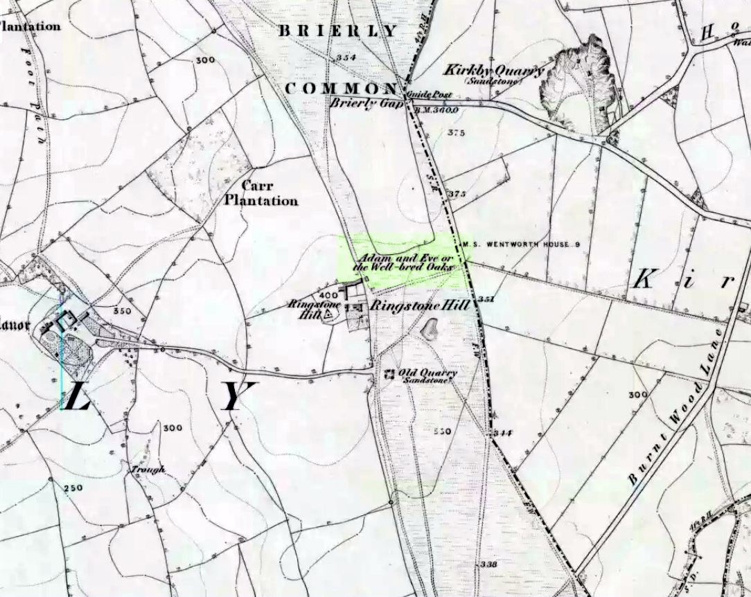
Highlighted on the 1854 Ordnance Survey map close to the township boundary line as Adam & Eve’s Oak, between Brierley and South Kirkby, I can’t find too much about this once great tree. However the Wakefield historian W.S. Banks (1871) told us the following:
“Upon the common at Ringston Hill grows the remarkable ‘old Adam’ oak, much decreased in size in late years. It is an ancient and large tree measuring twenty-seven feet in girth at a yard above the ground. The trunk is hollow and the north side is broken away. Most of the branches are also gone. In 1868 a very large branch was blown off by the wind; but on the southerly side are still some very vigorous limbs.”
The old oak on the 1854 map
Even when Banks wrote this he said how the tree “must be many centuries old.” In the time of King Charles II there used to be an old inn by Adam’s Oak at the foot of Ringston Hill, where the famous highwayman, Nevison (much-loved by many Yorkshire-folk because of his Robin-Hood-like character), used to stay. The inn was owned by one Adam Hawksworth, but was ordered “to have his sign taken down for harbouring Nevison.”
Folklore
W.S. Banks also wrote of this once great tree:
“The people at Brierley tell of Nevison the highwayman lodging in it and hiding stolen treasures in it, things which probably did not happen, though Nevison’s name is connected with Ringston Hill.”
The treasure legend may have more to do with the adjacent stone circle, as we find ‘treasure’ a common motif at such places.
References:
Banks, W.S., Walks in Yorkshire: Wakefield and its Neighbourhood, Longmans, Green Co.: London 1871.
Not too troublesome to locate really… It’s at the top-end of the University, just above the side of the small Hermitage Road, about 100 yards along. Keep your eyes peeled to your left!
Archaeology & History
Pathfoot Stone
Today standing proud and upright, this ruinous standing stone has been knocked about in the last couple of hundred years. Although we can clearly see that it’s been “fixed” in its present condition, standing more than 10 feet high, when the Royal Commission lads came here in August 1952 (as they reported in their utterly spiffing Stirlingshire (1963) inventory), it wasn’t quite as healthy back. They reported:
“Many years ago the stone, which is of dark grey dolerite, fell down and was broken, and the basal portion, now re-erected, is only 3ft 10in high; two large fragments however, still lie beside the base, and the original stone is said to have stood to a height of 9ft 4in. Of a more or less oblong section throughout, the re-erected stones measures 2ft 10in by 1ft 10in at ground level, swells to its greatest dimensions (3ft 2 in by 1ft 9in) at a height of 1ft 4in, and diminishes at the top…”
…and again!
But the scenario got even worse, cos after the Royal Commission boys had measured it up and did their report, it was completely removed! Thankfully, following pressure from themselves and the help of the usual locals, the stone was stood back upright in the position we can see it today. And — fingers crossed — long may it stay here!
Folklore
Commemorative plaque!
A plaque that accompanies the monolith tells that the old village of Pathfoot itself was actually “built around this standing stone” — which sounds more like it was the ‘centre’ or focus of the old place. An omphalos perhaps? The additional piece of lore described in Menzies (1905) work, that an annual cattle fair was held here, indicates it as an ancient site of trade, as well as a possible gathering stone: folklore that we find is attributed to another standing stone nearby.
Hutchinson, A.F., “The Standing Stones of Stirling District,” in The Stirling Antiquary, volume 1, 1893.
Hutchinson, A.F., “The Standing Stones and other Rude Monuments of Stirling District,” in Transactions of the Stirling Natural History and Antiquarian Society, 1893.
Royal Commission on the Ancient and Historical Monuments of Scotland, Stirlingshire – volume 1, HMSO: Edinburgh 1963.
Legendary Tree (destroyed): OS Grid Reference – SK 49751 83799
Folklore
This was one of the many sacred trees beneath or next to which, in pre-christian days, tribal councils met. Thanks to the local historians Paul Rowland and Lis Tigi Maguire Coyle (see ‘Comments’, below), the whereabouts of the tree has been located (contrary to my earlier idea that it had sadly died). The local writer Harry Garbutt wrote of it in the 1940s, saying:
“The importance of Harthill in Saxon days may be adduced also from the fact that of the Three Hundreds of the Wapentake, Harthill was one. The Hundred was the Court of local justice and government, and at Harthill would meet under the old Trysting Tree.”
The very word trysting relates to any species of tree that has importance, be it by its appearance or position, and relates to those that were used as traditional or popular meeting sites.
References:
Garbett, Harry, The History of Harthill-with-Woodall and its HamletKivetonPark, Arthur H. Stockwell: Ilfracombe n.d. (c.1948)
Acknowledgements: Massive thanks to Paul Rowland (‘Comments’, below), for information pointing us to the exact spot where our Trysting Tree lived; and to Lis Tigi Maguire Coyle for the additional folklore ‘Comment’, below. Huge thanks to you both!