Make a day out for this one! You could, of course, go barely half-a-mile straight up the hill (southwest) from Ossian’s Stone in the Sma’ Glen below – but it’s steep as fuck and I know that most of you wouldn’t do it. So, park-up and take the gradual 3 mile walk into the mountains. Coming via Crieff, along the A85 road east, turn left up the A822 Dunkeld road at Gilmerton. 2½ miles on, you reach the Foulford golf course on the right-hand side of the road, whilst directly across the road a dirt-track leads you into the fields, past the large Foulford cup-and-ring stone. Keep along this track, bearing right just before Connochan Lodge and follow this dirt-track uphill on and on for another 2 miles where you’ll eventually see the cairn-peak in the distance. Another shallow track leads uphill after about 2 miles: we walked up to where the ground levels out, walked across the dodgy swamp-land and up again to the tomb. It’s well worth it!
Archaeology & History
Visible for many miles round here from the surrounding hills, this somewhat mutilated giant cairn, highlighted on the earliest Ordnance Survey map of the area in 1867, hasn’t fared well in archaeology tomes. Apart from a passing note in Margaret Stewart’s (1966) summary article on prehistoric remains in central Perthshire—where she erroneously told it to be 400 feet lower down that it actually is—almost nothing has been said of this place. Most odd.
Cairn spoil, looking SENew cairn atop of the old
Despite it being ransacked over the centuries, it was obviously of some considerable size in its early days. Today, surmounting it, is a very large walker’s cairn which, no doubt, has accrued some of its own foundations from the prehistoric tomb on which it sits. To the side of this recent cairn, another one is growing, thanks to stones brought from near and not-too-far. But the original creation can still be seen in outline and mass all around. Indeed, as you walk all round the modern cairn, you’re walking over much of the early collapsed stonework sleeping gently beneath the moorland vegetation, and once you walk away and below the cairn mass itself, looking back up at it you’ll notice the very ancient raised plinth of stone on which our modern one now lives.
Low walling on NW side
Its amorphous shape is somewhat amoeboid, measuring more than 22 yards across east-west, by 15 yards north-south, with a curious arc of low walling, very old indeed, on its northwestern side. Whether this walling outlines the original edge of the tomb, only an excavation will tell. The most notable remaining mass of ancient cairn material reaches out on its south-east to eastern edges, where some of it is beginning to fall away down the edge of the mountain slope.
Folklore
Local tradition assigns this cairn to be where the bones of the great hero-figure Ossian was removed to, when they were disturbed by the unruly mob of General Wade and his cohorts in the middle of the 18th century. Notes of the event were written at the time by one of Wade’s mob, a Captain Edward Burt, who told,
“the Highlanders, they assembled from distant parts, and having formed themselves into a body, they carefully gathered up the relics, and marched with them, in solemn procession, to a new place of burial, and there discharged their fire-arms over the grave, as supposing the deceased had been a military officer.”
This was essential, said Burt, as
Site shown on 1867 mapNew cairn on old, looking W
“they (the Highlanders) firmly believe that if a dead body should be known to lie above ground, or be disinterred by malice, or the accidents of torrents of water, &c. and care was not immediately taken to perform to it the proper rites, then there would arise such storms and tempests as would destroy their corn, blow away their huts, and all sorts of other mis-fortunes would follow till that duty was performed. You may here recollect what I told you so long ago, of the great regard the Highlanders have for the remains of their dead…”
Oral tradition tells us that this cairn, high above Ossian’s Stone, is where the rites occurred. It makes sense too.
References:
Finlayson, Andrew, The Stones of Strathearn, One Tree Island: Comrie 2010.
Acknowledgements:Huge thanks for use of the Ordnance Survey map in this site profile, reproduced with the kind permission of the National Library of Scotland.
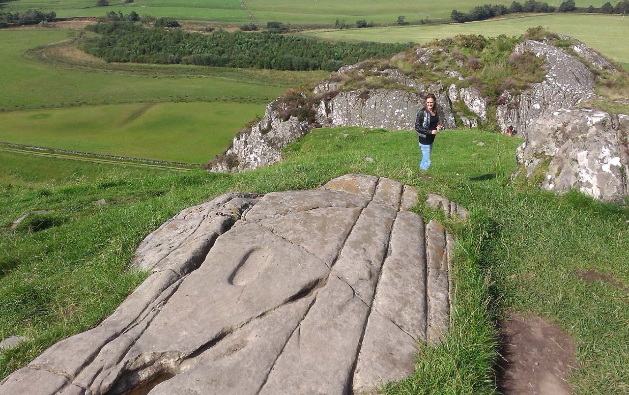
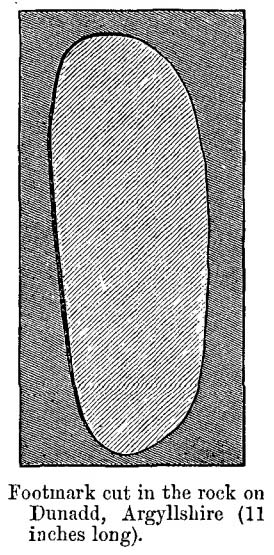
From Lochgilphead, take the A816 road north for several miles (towards the megalithic paradise of Kilmartin), keeping your eyes peeled for the road-signs saying “Dunadd.” Turn left and park-up a few hundred yards down. Go through the gate and walk up Dunadd. Just before the flattened plateau at the top, a length of smooth stone is accompanied to its side by the deep cup-and-ring of the Dunadd Basin. Three or four yards away, you’ll see the long ‘footprint’.
Archaeology & History
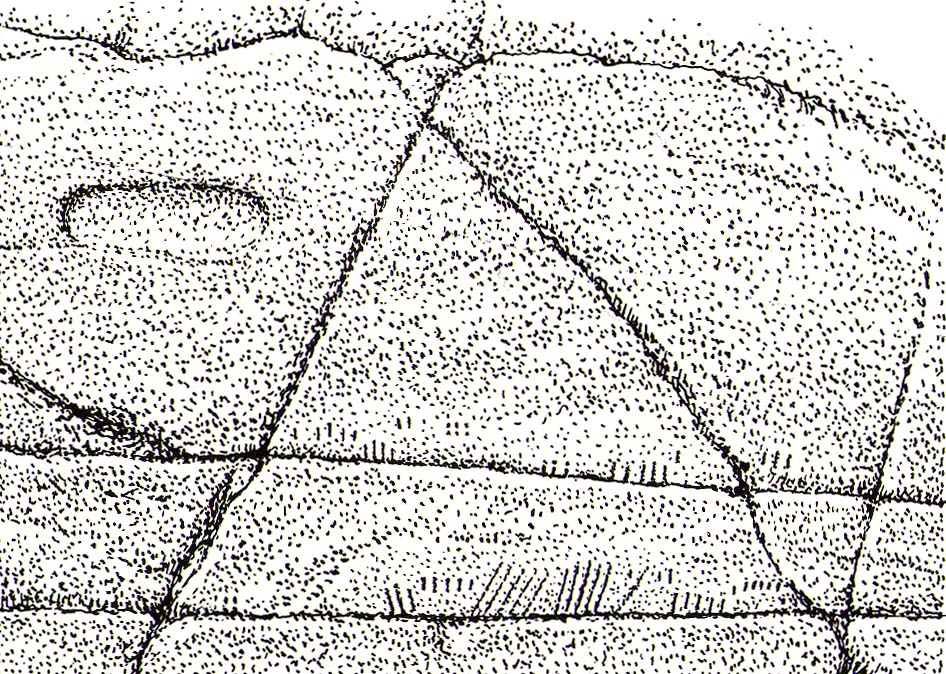
Near the top of Dunadd’s Iron Age ‘fortress’ and overlooking the megalithic paradise of the Kilmartin valley, several man-made carvings are in evidence very close to each other, all with seemingly differing mythic content. This one—the footprint—stands out; but it’s not alone! Faint etchings of at least one other ‘foot’ is clearly visible. The first literary account of it was by Ardrishaig historian R.J. Mapleton (1860), who told,
“There is on the top of Dunadd a mark that strikes me as interesting; it is like a large axe-head, or a rough outline of a foot. My impression is that it may have been the spot on which the chief would place his foot when succeeding to the headship of his tribe. The footmark was always considered among the people here as a mould for an axe-head, and I was rather laughed at for suggesting an inaugurating stone.”
Dunadd Footprint (after Royal Commission 1988)F.W.K. Thomas’ 1879 sketch
Be that as it may, a few years later the carving had caught the attention of the Scottish Society of Antiquaries. In his article exploring the potential for ritual inaugurations at Dunadd, Captain F.W.L. Thomas (1879) explored, not only the footprint, but the mythic functions of this symbol, looking at parallels with petroglyphs elsewhere in the world where the ‘foot’ was known to be a ritual inauguration symbol (amongst other things). He gave us the first real detailed account of the carving:
“About 10 or 12 feet below, and to the northward of the highest point, the living rock is smooth, flat and bear of sward, and in it is engraved an impression of a footmark, not of a naked foot, but such as would be made when the foot is clothed by a thick stocking or cuaran… The engravure is for the right foot; and it exactly fitted my right boot. The footmark is sunk half-an-inch deep, with perpendicular sides, the surface is smoothed or polished, and the outline is regular… It has probably been sheltered by the turf until recently. The footmark is 11 inches long, nearly 4½ inches broad where broadest, and 3½ inches across at the heel. When a person stands with his foot in the depression, he looks a little easterly of north.”
A century or so later when the Royal Commission (1988) boys got here, they found not one, but two ‘feet’ carved into the rock! A few feet away, near to the carved boar,
“At the south end of the main rock surface there is the lightly-pecked outline of a shod right foot. 0.24m long and 0.1m in maximum width, with a pronounced taper to the heel. There are further peck marks within the outline, and a sunken footmark was intended but not completed. This print is on almost the same alignment as the more prominent footprint some 2m to the north, which measures 0.27m from NNE to SSW, by 0.1m in maximum width and 25mm in depth. It is somewhat broader at the heel than the incomplete mark, and its sides are straighter.”
Close-up of the carving
They then emphasize how we’re unable to date the footprints, although point out how such carvings are “found in Britain from the Iron Age onwards.” But footprints have be found on other petroglyphs in Scotland (much less in England) and date between the neolithic and Bronze Age periods—but whether Dunadd’s example goes that far back, we cannot say. Extensive excavations occurred at Dunadd between 1980-81 and most of the finds were Iron Age and early medieval in nature (this carving and the cup-and-ring barely got a mention in Lane & Campbell’s [2000] extensive summation). But we may be looking at an evolutionary developmental relationship in symbolism and form, if the traditions of the place have any substance. This is something I’ll return to when writing of the Boar Carving, just a few feet away…
Folklore
The legends behind this seemingly insignificant mark near the top of Dunadd ostensibly echo and relate to the huge cup-and-ring of Dunadd Basin four yards away. I can only repeat what I said in that site profile.
R.J. Mapleton (1860) said that Dunadd was known by local people to be a meeting place of witches and the hill of the fairies, whose amblings in this wondrous landscape are legion. Legends and history intermingle upon and around Dunadd. Separating one from the other can be troublesome as Irish and Scottish Kings, their families and the druids were here. One such character was the ever-present Ossian. Mapleton told:
“From these ancient tales we turn to a much later period of romance, when Finn and his companions had developed into extraordinary and magical proportions; a story is current that when Ossian abode at Dunadd, he was on a day hunting by Lochfyneside; a stag, which his dogs had brought to bay, charged him; Ossian turned and fled. On coming to the hill above Kilmichael village, he leapt clean across the valley to the top of Rudal hill, and a second spring brought him to the top of Dunadd. But on landing on Dunadd he fell on his knee, and stretched out his hands to prevent himself from falling backwards. ‘The mark of a right foot is still pointed out on Rudal hill, and that of the left is quite visible on Dunadd, with impressions of the knee and fingers.’”
As Mr Thomas (1879) clarified:
“The footmark is that of the right foot, and the adjacent rock-basin is the fabulous impression of a knee.”
References:
Bord, Janet, Footprints in Stone, Heart of Albion Press 2004.
Campbell, Marion, Mid-Argyll: An Archaeological Guide, Dolphin Press: Glenrothes 1984.
Campbell, M. & Sanderman, M., “Mid-Argyll: An Archaeological Survey,” in Proceedings of the Society Antiquaries, Scotland, volume 95, 1962.
Craw, J.H. “Excavations at Dunadd and other Sites,” in Proceedings of the Society Antiquaries, Scotland, volume 64, 1930.
Lane, Alan & Campbell, Ewan, Dunadd: An Early Dalriadic Capital, Oxbow: Oxford 2000.
Mapleton, R.J., Handbook for Ardrishaig Crinan Loch Awe and Pass of Brandir, n.p. 1860.
Morris, Ronald W.B., The Prehistoric Rock Art of Argyll, Dolphin Press: Poole 1977.
Royal Commission on the Ancient & Historical Monuments of Scotland, Argyll – Volume 6: Mid-Argyll and Cowal, HMSO: Edinburgh 1988.
There are two ways into this glen by road. Whichever route you take (from Crieff side, or via the long Dunkeld route), when you hit the flat bottom of it, where the green fields are right by the roadside, walk along till you find the road meets the river’s edge. On the south-side of this small roadside section of the river, you’ll see a single large boulder 10-20 yards away. That’s the spot!
Archaeology & History
Described in some of the archaeology texts as just a ‘cist’, this giant stone is obviously the remains of much more. For a start, as the 1834 drawing illustrates here (coupled with several other early descriptions of the place), other visible antiquarian remains were very much apparent at Ossian’s Stone before a destructive 18th century road-laying operation tore up much of this ancient site. A marauding General Wade of the English establishment was cutting through the Scottish landscape a “military road”, to enable the English to do the usual “civilize the savages”, as they liked to put it. This curious “Giant’s Grave” was very lucky to survive.
Skene’s 1834 sketch, showing surrounding ringOssian’s Stone in the Sma’ Glen
The earliest description of events surrounding the site, as well as the attitude of the Highlanders when they saw the disrespectful English impose their usual disregard, is most insightful. In a series of letters written by a Captain Edward Burt (1759) in the first-half of the 18th century to the english monarch of the period, we read a quite fascinating account which must have been very intriguing to witness first-hand.
General Wade and his band of marauders had reached the Sma’ Glen at the end of Glen Almond and were about to continue the construction of their road. Burt (1759) wrote:
“A small part of the way through this glen having been marked out by two rows of camp colours, placed at a good distance one from another, whereby to describe the line of the intended breadth and regularity of the road by the eye, there happened to lie directly in the way an exceedingly large stone; and, as it had been made a rule from the beginning, to carry on the roads in straight lines as far as the way would permit, not only to give them a better air, but to shorten the passenger’s journey, it was resolved the stone should be removed, if possible, though otherwise the work might have been carried along on either side of it.
“The soldiers, by vast labour, with their levers and jacks, or hand-screws, tumbled it over and over till they got it quite out of the way, although it was of such an enormous size that it might be matter of great wonder how it could ever be removed by human strength and art, especially to such who had never seen an operation of that kind: and, upon their digging a little way into that part of the ground where the centre of the base had stood, there was found a small cavity, about two feet square, which was guarded from the outward earth at the bottom, top, and sides, by square flat stones.
“This hollow contained some ashes, scraps of bones, and half-burnt ends of stalks of heath; which last we concluded to be a small remnant of a funeral pile. Upon the whole, I think there is no room to doubt but it was the urn of some considerable Roman officer, and the best of the kind that could be provided in their military circumstances; and that it was so seems plainly to appear from its vicinity to the Roman camp, the engines that must have been employed to remove that vast piece of a rock, and the unlikeliness it should, or could, have ever been done by the natives of the country. But certainly the design was, to preserve those remains from the injuries of rains and melting snows, and to prevent their being profaned by the sacrilegious hands of those they call Barbarians, for that reproachful name, you know, they gave to the people of almost all nations but their own.
“…As I returned the same way from the Lowlands, I found the officer, with his party of working soldiers, not far from the stone, and asked him what was become of the urn? To this he answered, that he had intended to preserve it in the condition I left it, till the commander-in-chief had seen it, as a curiosity, but that it was not in his power so to do; for soon after the discovery was known to the Highlanders, they assembled from distant parts, and having formed themselves into a body, they carefully gathered up the relics, and marched with them, in solemn procession, to a new place of burial, and there discharged their fire-arms over the grave, as supposing the deceased had been a military officer.
“You will believe the recital of all this ceremony led me to ask the reason of such homage done to the ashes of a person supposed to have been dead almost two thousand years. It did so; and the officer, who was himself a native of the Hills, told me that they (the Highlanders) firmly believe that if a dead body should be known to lie above ground, or be disinterred by malice, or the accidents of torrents of water, &c. and care was not immediately taken to perform to it the proper rites, then there would arise such storms and tempests as would destroy their corn, blow away their huts, and all sorts of other mis-fortunes would follow till that duty was performed. You may here recollect what I told you so long ago, of the great regard the Highlanders have for the remains of their dead…”
Ossian’s Stone in his landscape
We can rest assured that the ‘Roman officer’ idea proclaimed by our early narrator is most probably wrong and that the nature of this site, when seen at ground-level even today and moreso by referencing Skene’s 1834 drawing of the place, above (which shows a more complete low surrounding ring of stones) indicate this to be of prehistoric provenance. Of intrigue to me, is the ritual of the incoming Highlanders, who took the relics onto another place and re-interred them in their own customary manner. We do not know where the Highlanders moved these (probable) prehistoric relics and I can find no supporting folklore to show precisely where they went—but a likely site would be the prehistoric cairn on the mountaintop southwest of here (at NN 8899 3018), or a site that has sometimes been confused with Ossian’s Stone a short distance to the south in the Sma’ Glen, known as the Giant’s Grave (at NN 9050 2956). This latter site would seem more probable.
Anyway…. many years after Edward Burt’s initial Letters defined the site for outsiders, one Thomas Newte (1791) came a-wandering hereby. He found that the account of General Wade’s intrusion was still on the tongues of local people, along with additions of further giant-lore and Fingalian tales, typical of the Creation myths of our early ancestors. In typically depreciative English manner Newte told:
“In that awful part of Glen Almon, already mentioned, where lofty and impending cliffs on either hand make a solemn and almost perpetual gloom, is found Clachan-Of-Fian, or monumental Stone of Ossian. It is of uncommon size, measuring seven feet and an half in length, and five feet in breadth. About fifty years ago, certain soldiers, employed under General Wade in making the Military Road from Stirling to Inverness, through the Highlands, raised the stone by large engines, and discovered under it a coffin full of burntbones. This coffin consisted of four gray stones, which still remain, such as are mentioned in Ossian’s Poems. Ossian’s Stone, with the four gray stones in which his bones are said to have been deposited, are surrounded by a circular dyke, two hundred feet in circumference, and three feet in height. The Military Road passes through its centre.”
Cole’s 1911 plan of stone & surrounding ringOssian Stone by Fred Cole
From hereon, many other writers and travellers came to see this great legendary stone within the depleted remains of its embanked circle—and thankfully it hasn’t been disturbed any further, still being visible to this day. The greatest ‘archaeological’ attention the site has received was from the early pen of great antiquarian Fred Coles (1911). On his journey here, after travelling past a large white stone which was mistakenly named as Ossian’s Stone by the usual contenders, he and his friend reached the right place:
“close to a strip of ground where the river and road almost touch each other, and immediately below the steepest of the crags of Dun More on the eastern side and the debris slopes of Meall Tarsuinn on the west, a most impressive environment, be the stone a prehistoric monument or not! The spot is interesting for itself, apart from all legend; and the remains consist of a mighty monolith…and a narrow grassy mound…to its east, with a few earthfast blocks set edgewise near its eastern extremity. Close to the roadside, but at the same level of 690 feet above the sea, there is a slab-like stone set up, measuring 3 feet in width, 1 foot 3 inches in thickness, and about 2 feet 6 inches in height. A space of 63 feet separates this block…from the huge rhomboidal mass called Ossian’s Stone. Five feet east of the latter is the base of the grassy mound which measures about 12 feet in length, 4 feet in greatest breadth, and 3 feet 10 inches in height. To the north and the south in a slightly curving line are set the six small slabs shown. There seems also to be a vague continuation of this strange alignment in both directions. All over the ground between A and B, are many strangle low parallel ridges of smallish stones having a general direction of nearly north and south. The rest of the ground is grassy, and here and there a little stony. In the plan all the stones are drawn larger than exactly to scale.
“The great stone is 8 feet high and has a basal girth of 27 feet. Several small stones lie near it. Such are the facts as at present to be observed on the ground.”
Section of outlying grass-covered low ring, just visibleGeological cup-marks?
There are two small conjoined cup-marks on top of the stone, but these seem to be geological in nature. The precise nature of the site is difficult to ascertain without excavation; but the Royal Commission lads reckon it to be a prehistoric ‘cist’ or grave in their own analysis, based mainly on the quoted literary texts. The surrounding ‘ring’ of small stones doesn’t seem to have captured their attention too much; but the site needs contextualizing within this damaged circular enclosure, which appears to have been a cairn circle initially, of some sort, with Ossian’s huge stone resting over the grave of one late great ancestral character, probably placed here thousands of years back in the Bronze Age… A truly fascinating place in truly gorgeous landscape.
Folklore
The glen itself has a scattering of giant lore associated with Finn and/or Ossian. A nearby cave was one of the places where this legendary character, and subsequent bards, were said to have spent time.
There are a small number of heavy rocks presently placed on top of Ossian’s Stone. These may be due to the site being used as a “lifting stone”: a sort of rite of passage found at a number of sites in the Perthshire mountains and across the Highlands to indicate a boy’s strength before entering manhood. Not until they have lifted and deposited a very heavy rock onto the boulder can they rightly become chief or leader, etc.
The poet William Wordsworth wrote about Ossian’s Stone, calling it “Glen Almein, or The Narrow Glen”:
In this still place, remote from men,
Sleeps Ossian, in the Narrow Glen;
In this still place, where murmurs on
But one meek streamlet, only one:
He sang of battles, and the breath
Of stormy war, and violent death;
And should, methinks, when all was past,
Have rightfully been laid at last
Where rocks were rudely heaped, and rent
As by a spirit turbulent;
Where sights were rough, and sounds were wild,
And everything unreconciled;
In some complaining, dim retreat,
For fear and melancholy meet;
But this is calm; there cannot be
A more entire tranquillity.
Does then the Bard sleep here indeed?
Or is it but a groundless creed?
What matters it? I blame them not
Whose Fancy in this lonely Spot
Was moved; and in such way expressed
Their notion of its perfect rest.
A convent, even a hermit’s cell,
Would break the silence of this Dell:
It is not quiet, is not ease;
But something deeper far than these:
The separation that is here
Is of the grave; and of austere
Yet happy feelings of the dead:
And, therefore, was it rightly said
That Ossian, last of all his race!
Lies buried in this lonely place.
References:
Anonymous, Tourists Guide to Crieff, Comrie and the Vale of Strathearn, Crieff
1874.
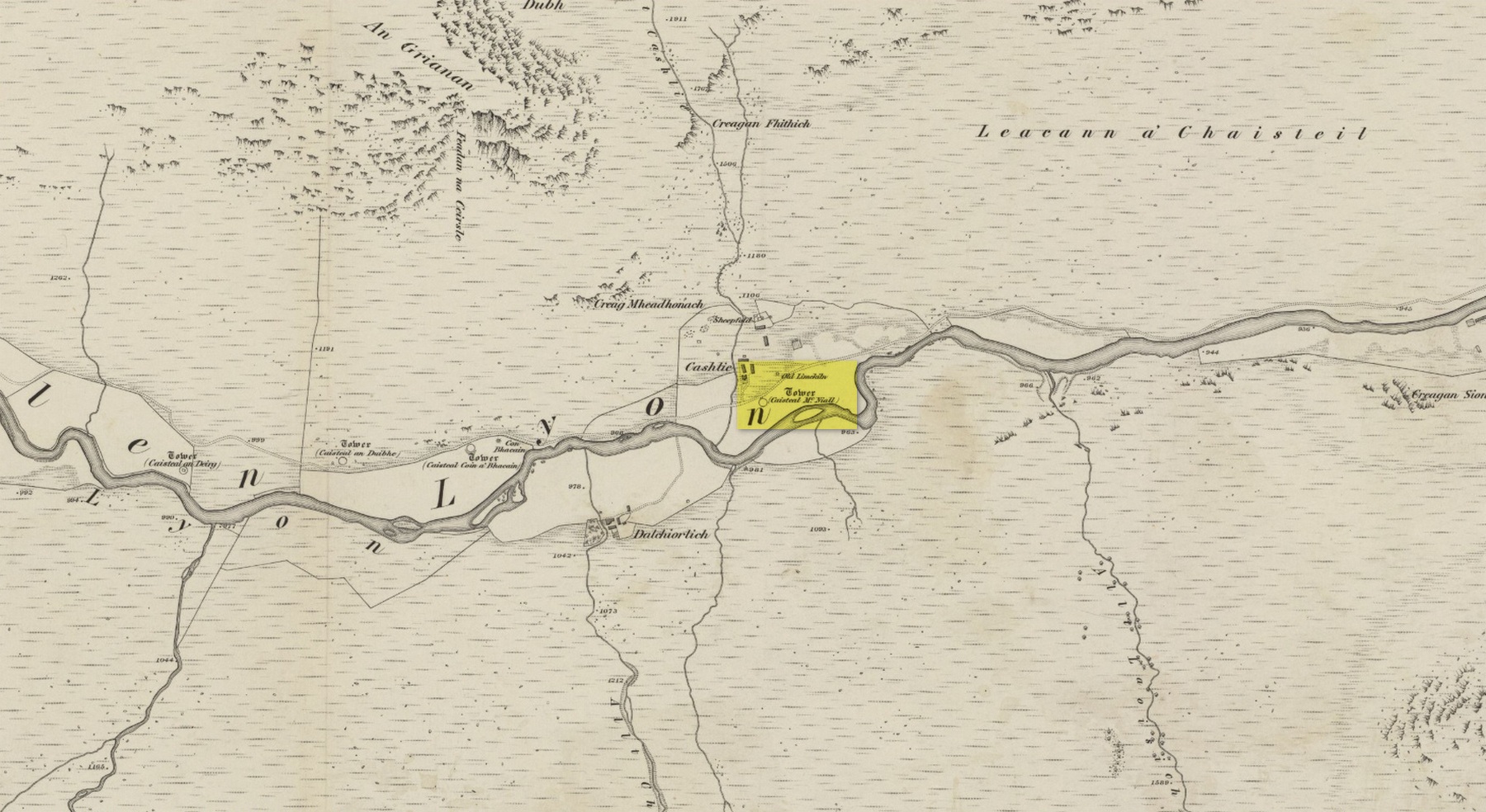
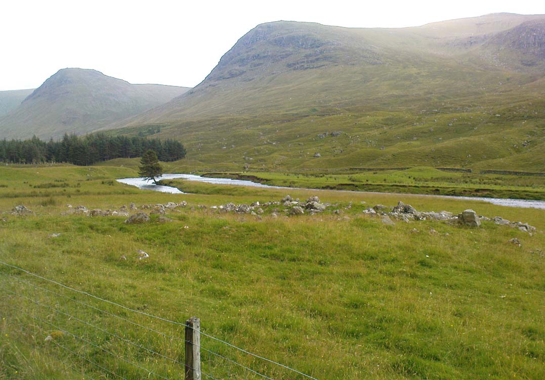
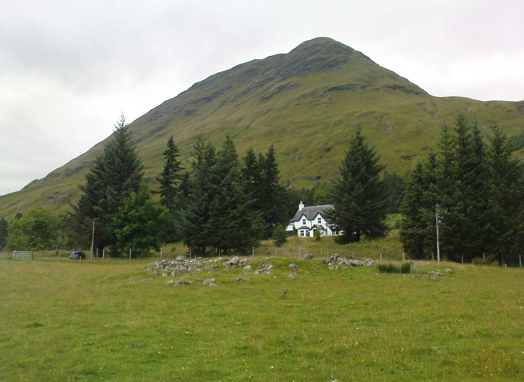
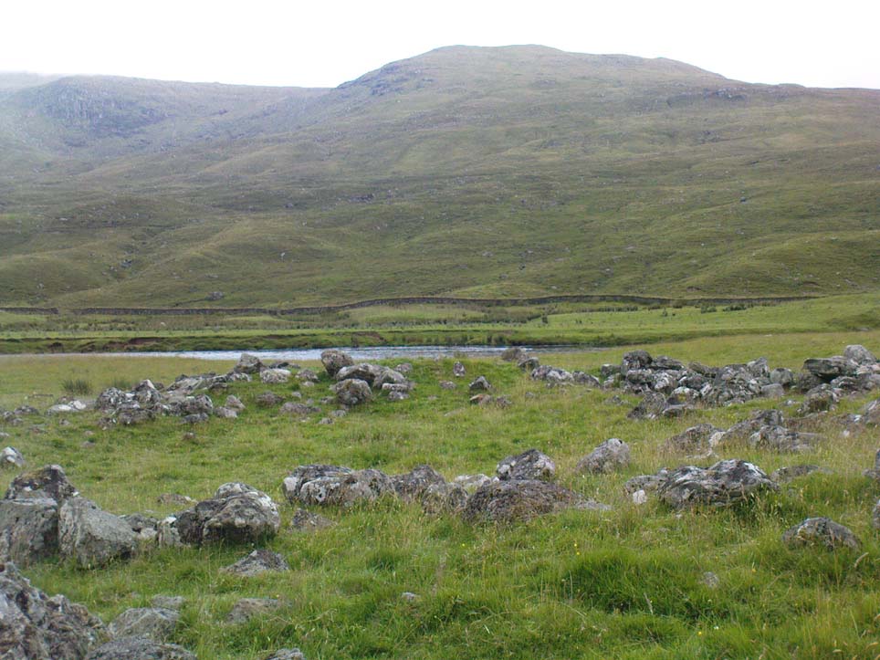
Truly remote, but easy to find once you’re nearing the western end of Glen Lyon. Going upstream, past Cashlie Dam, watch out for the well-preserved stone kiln on the left-hand side of the road, just before Cashlie house. 50 yards or further along, cross the road and in the field by the riverside, the circular mass of stones sorta gives the game away.
Archaeology & History
Shown on modern OS-maps as a ‘homestead’ and described variously by archaeologists and historians as a fort or a round-house, this is just one example of around twenty large prehistoric constructions that scatter the stunning mountainous Glen Lyon region which legend tells were the forts of the great hero-figure, Finn. Three other constructions of the same nature are found just a few hundred yards further up the Glen from here. Each is of roughly the same age and nature by the look of things. Their walls are extremely wide and made up of very large rocks, which would have taken huge efforts to construct.
Caisteal Mhic Neill ruins, looking eastCaisteal Mhic Neill, with An Grianan behind
Highlighted on the 1867 OS-map as a “Tower”, the exact nature of this and its adjacent sites has yet to be academically ascertained, with the Canmore website ascribing the monument as a “settlement” – although, tradition tells them to be Scottish forts or duns, so we’ll stick with that until excavations tell otherwise!
The great Gaelic place-name master W.J. Watson (1912) told that:
“The fourth of the Cashlie towers is a few yards south of the road, right in front of Cashlie farmhouse, now a shooting lodge. Though a quantity of large stones marks the site, the structure has been so badly knocked about that we found it impossible to take measurements sufficient for a plan. It was, however, apparently not circular, but rather oval. Its walls appeared to vary from about 9 feet to 12 feet 6 inches in thickness.”
Close-up of Caisteal walling
This is one of several other duns (or homesteads as the OS-map calls them) close to each other.
Folklore
Ascribed as one of Glen Lyon’s Caisteilean nam Fiann, or “castles of the Fiann”, Mr Watson (1912) again told how “there is a widely known saying, the earliest notice of which occurs in Pennant, who got it doubtless from the Rev. J. Stewart:
‘…Twelve castles had Fionn,
In the dark Bent-glen of the stones.'”
References:
Gillies, William A., In Famed Breadalbane, Munro Press: Perth 1938.
Watson, W.J., “The Circular Forts of North Perthshire,” in Proceedings of the Society of Antiquaries, Scotland, volume 47, 1912.
ACKNOWLEDGEMENTS: Many thanks to Andy Sweet of Stravaiging Around Scotland, for pointing me to the W.J. Watson article. And of course, a huge thanks to Marion—”I don’t have a clue where I am!”—Woolley, for getting us here….