Cup-Marked Stone (lost): OS Grid Reference – NH 814 503
Archaeology & History
Somewhere on the outskirts of Kilravock Castle grounds sat (or still sits, hopefully) one of our country’s legendary healing stones bound within the animistic veil of a cup-marked stone. It seems to have fallen off the archaeological registers (if it was ever included!) and so I add it here in the hope that someone can locate it and let us know of its present condition.
Described during a meeting of the Inverness Scientific Society by a Dr Grigor in a short presentation on cup-marked stones at Nairn in July 1884, the matter of some faint traditions concerning a tiny number of cup and ring stones in Scotland was mentioned, and,
“Dr Grigor said he would be able, next day, at the roadside on the Kilravock property, to point out a large rounded stone of gneiss, in the centre of which is a large cut cup-mark of a diameter of six or seven inches which, fifty years ago, was resorted to by many, and water was taken from it long distances. The water was believed to cure skin diseases, but it was principally used for washing warts on the human subject, which it was believed the water quickly removed. It was also particularly in repute for removing warts from cow’s teats.”
The custom described here sounds very similar to others found at so-called ‘Wart Stones’ in England and Scotland (there was one that existed a short distance from where I grew up near Eccleshill, West Yorkshire). Several miles west of here is the cluster of prehistoric carvings in the Clava complex, but this one at Kilravock seems to have fallen off the radar. Does anyone know if it can still be seen? (the grid-reference given to this site is an approximation)
References:
Grigor, Dr, “Cup Marked Stones,” in Transactions Inverness Scientific Society Field Club, volume 3, 1884.
Acknowledgements:Huge thanks for use of the Ordnance Survey map in this site profile, reproduced with the kind permission of the National Library of Scotland.
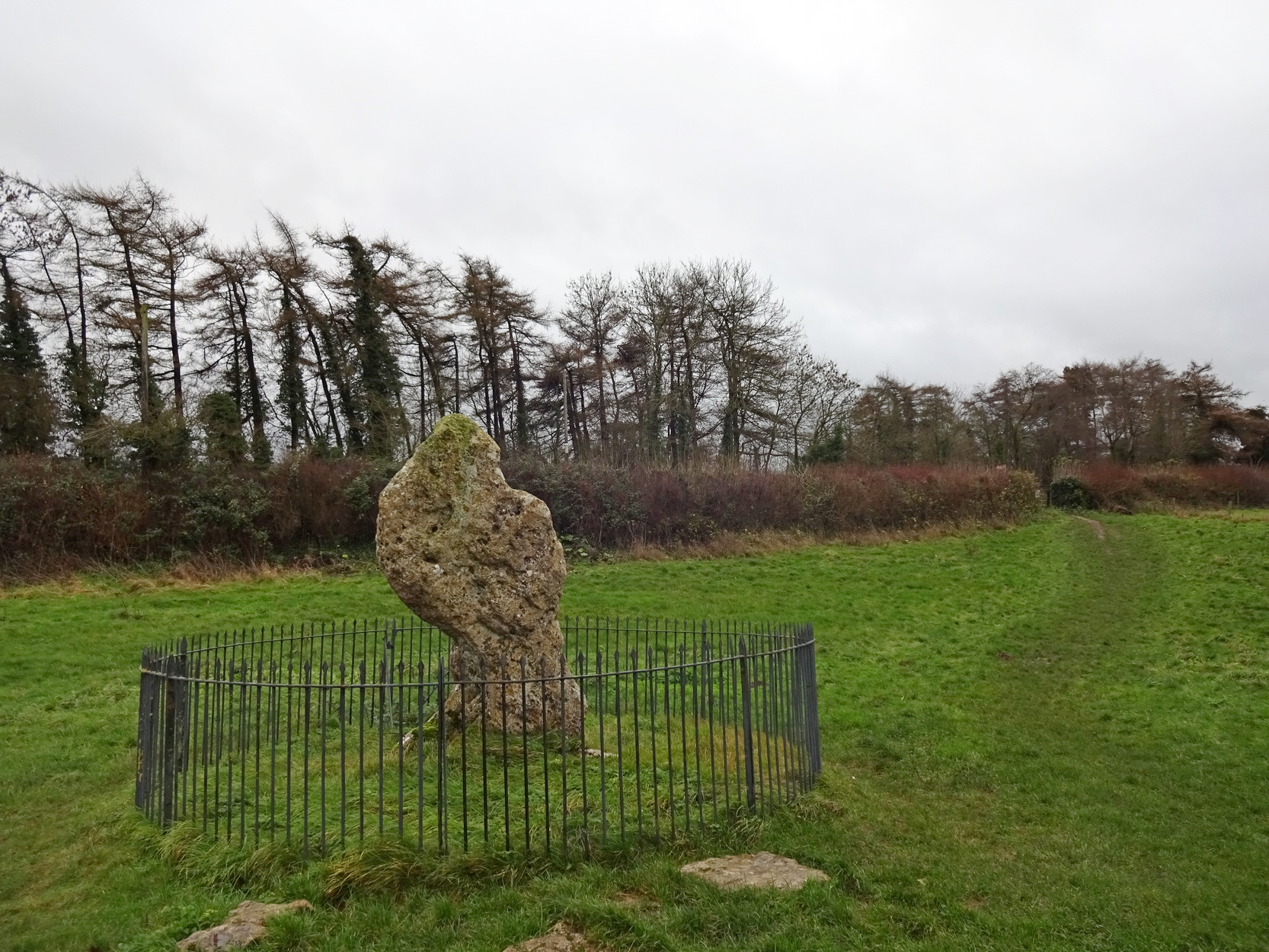
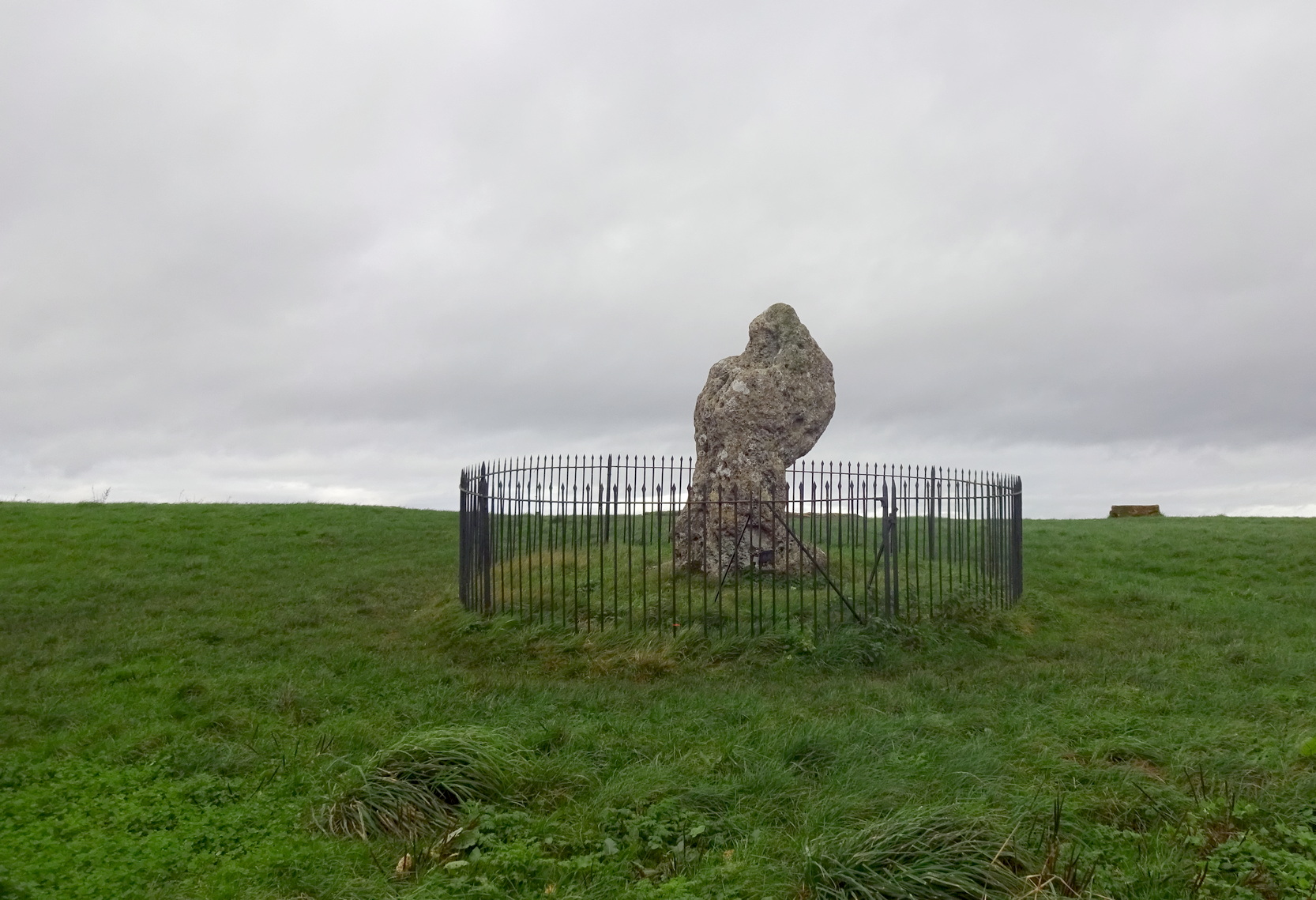
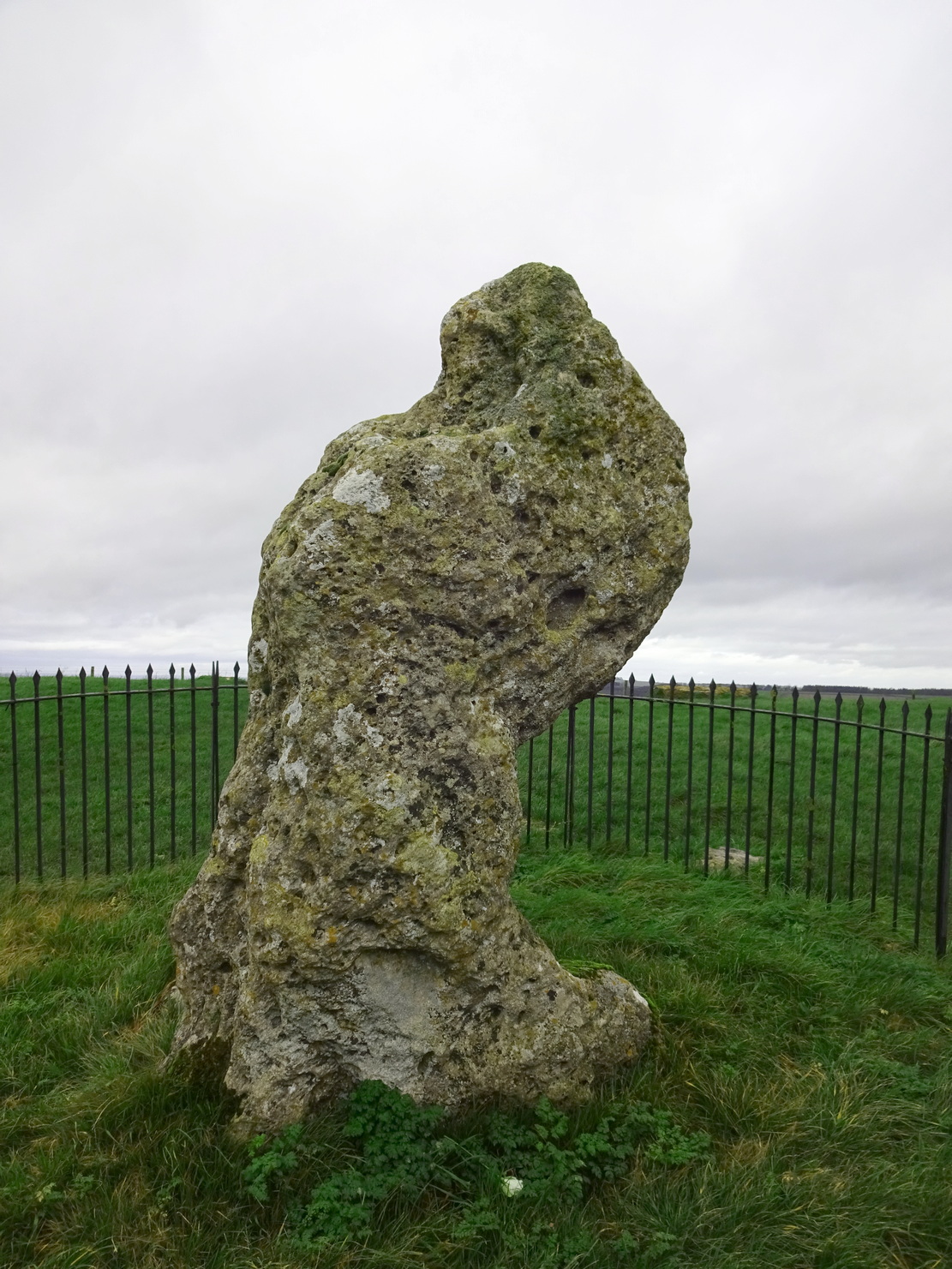
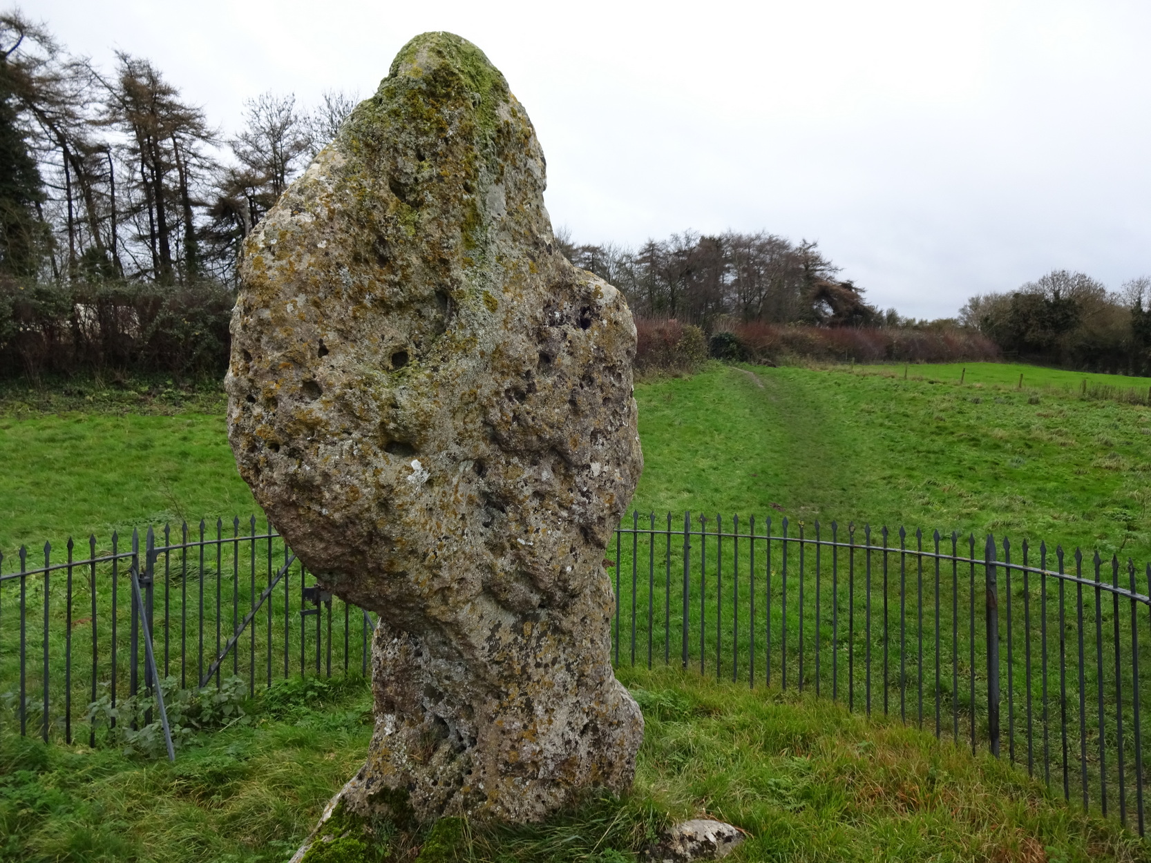
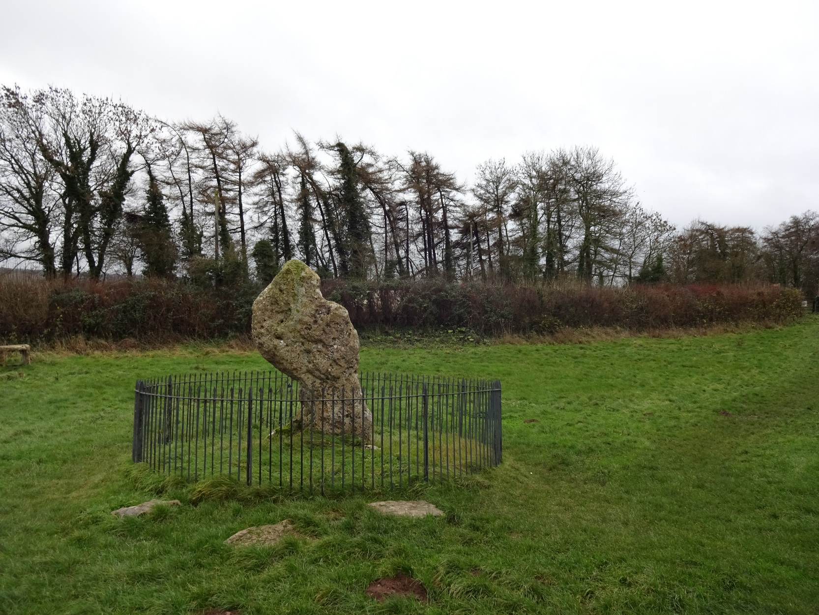
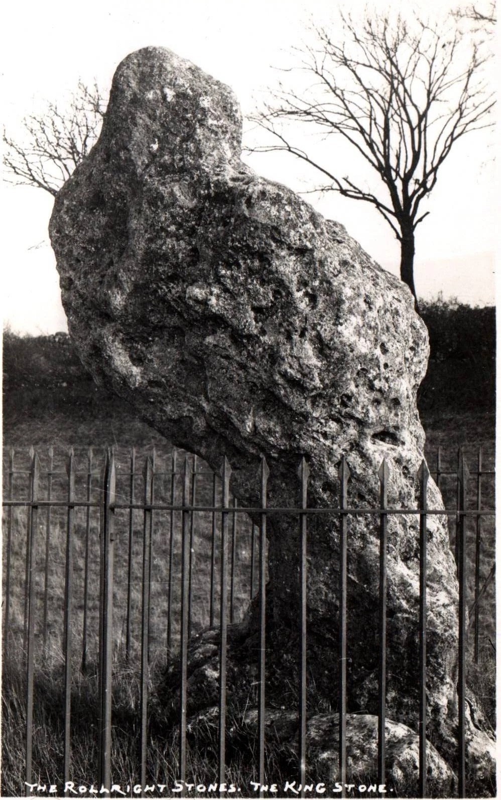
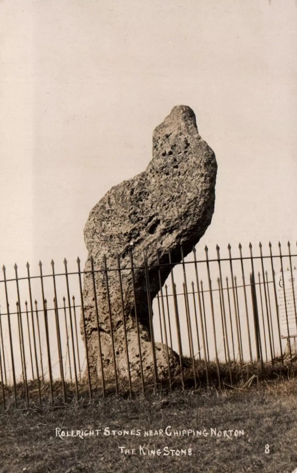
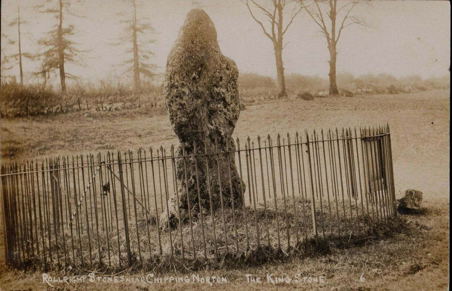
The King Stone of Rollright (photo by Sir Wilson III)
If you’ve reached the impressive Rollright Stone circle, simply cross the road, go through the gate and into the field, then up the gentle slope to your right. Y’ can’t miss it! If though, by any chance, you can’t find the Rollright Stones, get to Chipping Norton and ask a local!
Archaeology & History
An integral part of the Rollright Stones complex, this gnarled almost moth-eaten-looking standing stone, whose edges were cut away for medicinal properties in earlier centuries, still awakes each morning beside the small rise in the field, long thought to have been the remains of an ancient tomb — much to the archaeologist’s opinionated disdain in bygone years. Yet they had to swallow their pride…
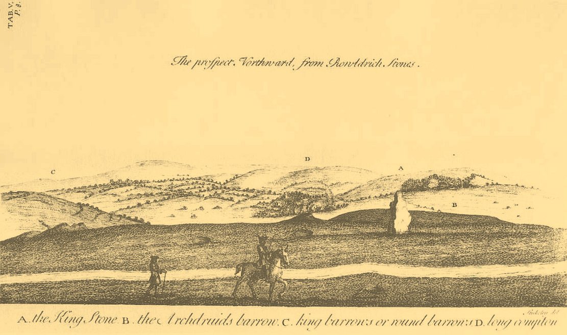
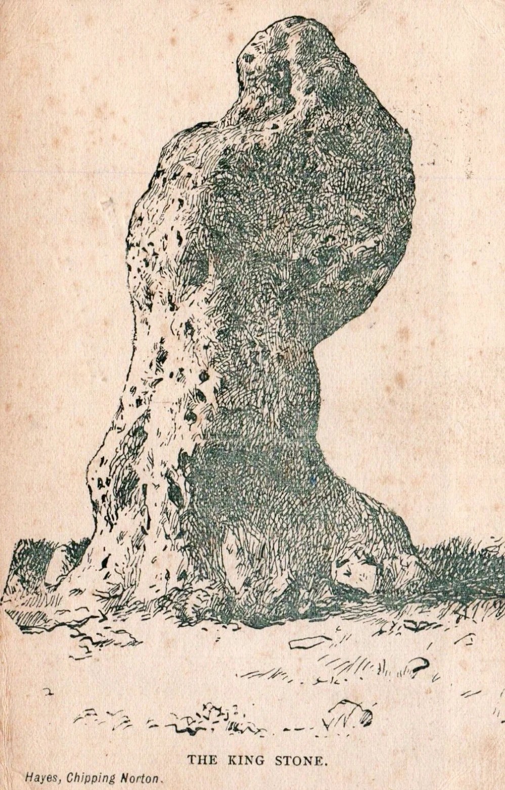
This is an eight-foot-tall standing stone made from the same local oolitic limestone as the King’s Men and overlooks the village of Long Compton on the northern side of the ridge. It actually stands besides an artificial mound which has been identified as a Bronze Age cairn—known in times past as the ‘Archdruid’s Barrow’— and suggested by Lambrick to date from around 1800 BCE. More recently however, the world’s leading authority on stone circles, Professor Aubrey Burl, has given the King Stone a more probable construction date of 3000 BCE. The date is consistent with other Neolithic finds in the adjacent fields. This old standing stone has suffered much down the centuries, with bits of it being chipped away to such an extent that it has been reduced to the novel shape we see today.
Looking up at the King (photo by Sir Wilson III)The King in dance
A little-known but important piece of megalithic history took place here in the 1970s and ’80s. It centred around an idea to investigation so-called “mysterious events” that are commonly reported at standing stones—and the King Stone has its own CV when it comes to such things. Curious stories have been described by people from all walks of life. Down the years, a number of people have told me of feeling some strange and powerful ‘energy’ at these places and stories of such things have filled many volumes, along with being the subject of many a folktale. So one evening in November, 1977, the then editor of The Ley Hunter, Paul Devereux, convened a meeting where twenty people from differing backgrounds gathered. At this first meeting were people from a variety of professional backgrounds: archaeologists, dowsers, chemists, biochemists, biologists, electronic engineers, geochemists, geophysicists, zoologists—and ley hunters of course. It was time, they thought, to address this issue of anomalous energies at stone circles and other ritual sites.
After some discussion about what they should call their investigations, “the long association of the dragon with some kind of earth force made it a fitting symbol.” And so, the Dragon Project (DP) was born…
On the misty morning of Saturday, 24 October, 1978, research scientist Don Robins—in the company of his dog and young son—drove the hundred miles from London to the Rollright Stones armed with a simple ultrasound detector. He didn’t know what he would find there, and his scientific training told him there shouldn’t really be anything untoward.
King Stone, looking W (photo by Sir Wilson III)Stukeley’s 1743 sketch showing the King Stone
Arriving around dawn, Robins took several background readings along some of the lanes a mile or so away and found the usual expected background levels (on a scale of 1-10, the background flickers between 0 and 1). When he eventually walked into the Rollright stone circle with his ultrasound monitor, no undue perturbations were found. He spent thirty minutes here, but at no time did he record anything other than background readings. So he crossed the road and tried the same at the King Stone—where a big surprise awaited him.
Switching on the detector he found an anomalously high reading, beating every minute or so, not unlike a heartbeat, more than five times above the background ultrasound!
“This was really peculiar,” he wrote, “in that the pattern was spread over about a minute and then commenced again after about 10 seconds, endlessly repeated.” Robins spent some time here and found that the strange ‘pulse’ wasn’t solely confined to the King Stone, but spread some distance around the old standing stone and onto the road itself.
Investigation of potential radiation anomalies was another avenue of enquiry explored by the Dragon Project, and although thousands of hours of monitoring were done at the three focal sites, there were few anomalies to write home about. Two however, were recorded in March and August, 1981, when radiation levels were twice the normal background rate for short periods of just a few minutes each. More puzzling was the finding—which can still be verified today—of radiation levels three and four times above background on the road between the circle and the King Stone.
Next on the list was an attempt to monitor the Rollright stones with infrared devices. This proved to be a potential goldmine, as there was the chance of photographic imagery. So early one morning in April, 1979, Paul Devereux readied himself at the King Stone. He took a number of photos at five minute intervals either side of sunrise. This time of day was chosen because of the repeated anomalous ultrasound emissions from the King and it was thought that this, if any, would be the best time to capture something on film.
“When the first roll of black-and-white IR film was professionally developed,” he wrote, “I was astonished to see a curious ‘glow’ effect around the King stone on the frame taken at sunrise.” His first account of it appeared in The Ley Hunter, where he described how “a hazy glow can be seen clinging to the sides and upper parts of the megalith. This glow becomes much stronger at the top of the stone where it looks like a cap of light.” Although the sun had risen, it was off to the left of picture and apparently no satisfactory explanation can be given to the effect on the plate. Research physicist Simon Hasler—who worked for Kodak—closely studied the negatives of this image and found the evidence for a simple explanation “weak.” A possible explanation of the mysterious glow was propounded by Don Robins, who suggested that an emission of microwaves from the stone may have been responsible, and although this sounds promising it has yet to be proven.
Folklore
(photo by Sir Wilson III)
Amidst the mass of modern lore, dowsed energy lines exceed here — although to be honest, most of them are little more than bullshit. Old school alignments in the form of leys that can be walked along are more credible, and one or two have been noted here. Dowser Laurence Main found a ley running between Broughton Church, “the old White Cross, the Victorian Cross and the old Bread Cross in Banbury. In the other direction the line led straight to the King Stone.” Although this line accurately links up these sites, other ‘ley points’ are utterly necessary between Broughton Church and the King Stone to give the alignment any real credibility. In a concise survey of the megalithic remains of this region made by Tom Wilson and myself, no other ley-points were found along the line.
In more traditional animist-based folklore, the creation myth here is well known. The famous, oft-repeated tale recites how a King and his men were marching across the land intent on conquering it when he came across an old hag, or witch near Rollright who offered the regal figure a magickal challenge. Some accounts name the witch as Mother Shipton—not the famous Yorkshire seer of the same name, but her less powerful (obviously!) southern counterpart. The old witch said to the King:
“Seven long strides thou shalt take, and
If Long Compton thou can’st see,
King of England thou shalt be.”
His majesty took this as a simple task and, with contempt, said to the old witch:
“Stick, stock, stone,
As King of England I shall be known.”
From where he was standing (which is never told, but presumed by most as the stone circle) the King then took seven long strides in the direction of Long Compton. As he was taking his seventh step the witch made the ground in front of him rise up, hence blocking his view of the village in the valley below. The old hag then said:
“As Long Compton thou canst not see,
King of England thou shalt not be.
Rise up, stick, and stand still, stone,
For King of England thou shalt be none;
Thou and thy men hoar stones shall be
And I myself an eldern tree.”
Thereupon, the King’s men who were waiting behind their master, the five knights in the field who were said to be conspiring against his majesty, and the King himself, were all turned into stone where they stood. The elder tree that the old witch turned herself into, was said to have grown along the old boundary close to the roadside, but this can no longer be verified. The folklorist Arthur Evans described several spots where the famed elder tree was said to have grown: one in the field close to the Whispering Knights, and another in the same field as the King Stone, close by another large stone that has long since gone.
When William Stukeley visited the area in the 18th century and heard about the legendary origin of these great monoliths, he told how “the country people for some miles round are very fond of, and take it very ill if anyone doubts it,” telling later, “The people who live at Chipping Norton and all the country round our first described temple of Rowldrich affirm most constantly, and as surely believe it, that the stones composing this work are a king, his nobles, and Commons turned into stones.
Another piece of animistic lore tells how the King Stone and the Whispering Knights venture, at midnight, less than half a mile south to drink from a spring in the small woodland at Little Rollright Spinney—although it is difficult to ascertain precisely which of the two springs the stones are supposed to visit. In some accounts, the stones reputedly drink from the well every night, but others tell that they only go there at certain times of the year, or on saint’s days. When Arthur Evans wrote of these tales he described there being a “gap in the bushes… through which they go down to the water,” but the terrain has altered since his day.
A variation of the same tale was told by T.H. Ravenhill, who wrote:
The old King c.1945King Stone, c.1920
“The Lord of the Manor of Little Rollright desired to possess the King’s Stone in order to bridge Little Rollright brook. So he dug it up and tried to cart it away, but found that he had not enough horses. He hitched on more, and yet more, and still he found that he could not move the stone. Finally he succeeded and hauled the stone away to the Manor House. The same night he was alarmed by strange sounds about the house, which he attributed to the presence of the King’s Stone, and decided, therefore, to replace it on its mound. No sooner had he harnessed the first horse to the cart than it galloped away up hill with ease, taking with it the stone, which leapt to position on reaching its resting place.”
Evans also wrote about an eighty-year-old local woman who told that her mother visited the King Stone on Midsummer’s Eve, along with many other locals, when the elder was in full bloom and they would stand in a full circle around the tall monolith. Ritual of a sort was performed then the elder tree was cut and, as it bled, “the King moved his head.” This annual rite was said to partially disempower the witch of her magickal hold over the King when her blood trickled from the tree. Some locals believed that if but a pin-prick of the witch’s blood was drawn, she would lose her power for all eternity.
Beneath both the Rollright stone circle and the King Stone, legend reputes there to be such a cavern where the little people live. In some accounts they are said to dance around the old King.
Arthur Evans told how one local man, Will Hughes, actually saw the faerie dancing round the King.
“They were little folk like girls to look at,” he said.
Old postcard, c.1910Sketch from 1904
Will’s widow, Betsy Hughes, told Evans that “when she was a girl and used to work in the hedgerows, she remembered a hole in the bank by the King Stone, from which it is said the fairies came out to dance at night. Many a time she and her playmates had placed a flat stone over the hole of an evening to keep the fairies in, but they always found it turned over next morning.” This curious entrance was a neolithic burial mound. Mark Turner described how the little people were “supposed to come out and dance around the stones by moonlight.”
As we have already seen, people used to take chippings off some of the old stones here—primarily the King—supposedly for luck, protection and good fortune. Local people used to blame Welsh workers more than anyone, but they wouldn’t be the only ones! Although those who took such chippings believed the pieces brought them luck, more often than not it was the opposite that happened. One local woman told Evans about her son who went to India as a soldier in the 19th century with a piece of the King Stone in his possession, but it did him no good whatsoever. He died of typhus! The Oxford archaeologist George Lambrick (1988) highlights in his book on the Rollright stones the extent of damage that has been done to the King Stone since 1607.
References:
Anonymous, The Rollright Stones: Theories and Legends, privately printed, n.d.
Bennett, Paul & Wilson, Tom, The Old Stones of Rollright and District, Cockley: London 1999.
Bloxham, Christine, Folklore of Oxfordshire, Tempus 2005.
Cowper, B.H., ‘Oxfordshire Legend in Stone,’ Notes & Queries (1st series), 7, January 15, 1853.
Devereux, Paul, ‘Is This the Image of the Earth Force?’ in The Ley Hunter 87, 1979.
Devereux, Paul, ‘Operation Merlin,’ in The Ley Hunter 88, 1980.
Devereux, Paul, ‘Operation Merlin 2,’ in The Ley Hunter 89, 1980.
Devereux, Paul, ‘The Third Merlin,’ in The Ley Hunter 92, 1981.
Devereux, Paul, Places of Power, Blandford: London 1990.
Devereux, Paul, The Sacred Place, Cassell: London 2000.
Evans, Arthur J., ‘The Rollright Stones,’ in Trans. Bristol & Glouc. Arch. Soc., 40, 1892.
Evans, Arthur J., ‘The Rollright Stones and their Folklore (3 parts),’ in Folklore Journal, 1895.
Lambrick, George, The Rollright Stones: The Archaeology and Folklore of the Stones and their Surroundings, Oxford Archaeology Review 1983. (Reprinted and updated in 1988.)
Michell, John, Megalithomania, Thames & Hudson: London 1982.
Pennick, Nigel & Devereux, Paul, Lines on the Landscape, Hale: London 1989.
Ravenhill, T.H., The Rollright Stones and the Men Who Erected Them, Little Rollright 1926.
Holy Well (destroyed): OS Grid Reference – NN 9397 5770
Archaeology & History
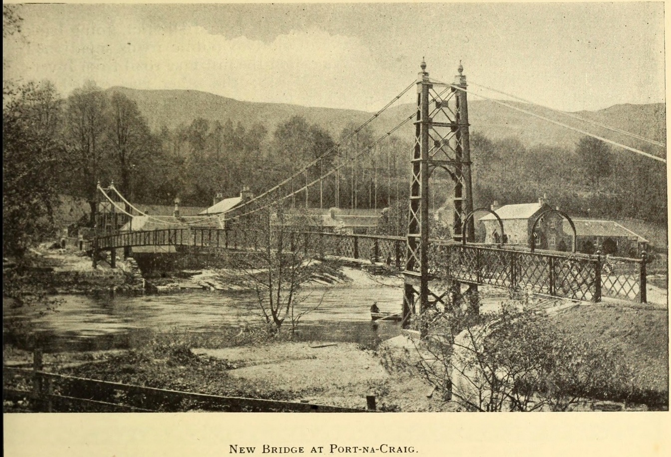
It was more than a hundred years ago that the waters of this sacred well fell back to Earth. They emerged above the eastern side of the River Tummel, close to the bridge where previous there had been a local ferry at the site known as Port-na-Craig. The mythic history of the ferry and the holy well went hand-in-hand, according to local tradition. Its lore was was spelled out by the local author and historian Hugh Mitchell in a speech he gave when a new bridge was opened here in 1913. He said:
The Well was on the far side of the bridge
“The ferry at Port-na-Craig, though not as old as many ferries in Scotland, bears the respectable antiquity of something like eight hundred years. It was established by the monks of Coupar Angus when they got a gift of the lands of Fonab, and as Coupar Angus lay on the north side of the river Tummel, they established the ferry in order to have communication. In those days the ferry boat was made of skins stretched on branches or twigs, so it was somewhat dangerous to cross in, and the monks thought that they would improve the occasion by dedicating the well near the old ferry to St. Bride, so that people, when they ventured across the ferry, might propitiate the saint. It was customary for people to drop either a small coin or a brass pin into the well. He was afraid that brass pins rather prevailed, and no doubt, St. Bride, being a lady, would find them more useful. The well remained until recent times, when it had, unfortunately, to be filled up, on account of being contaminated by neighbouring fields.”
For “fields”, read sewage—for that was the actual reason it was closed. Mr Mitchell (1923) told as much in his subsequent history of Pitlochry, saying that “sewage was percolating into it.” John Dixon (1925) echoed the same thing a few years later.
The curative and magickal properties of St Bride’s Well had considerable renown for local people. Mitchell told that:
“It had a great reputation at one time for cases of lung disease… Pins and coins were dropped into the well as votive offerings, and the bushes above it were hung with rags to call the attention of the saint to the sufferer.”
A few miles north from here, at the back of Blair Castle, an old church is dedicated to St. Bride, whose celebration date is February 1. “The day was known as Candlemas in the Highlands,” wrote Mrs Banks, saying, in commemoration of the Celtic Brigit, “Feill Bride, the festival of Bride, displaced the festival of Mary.”
References:
Dixon, John H., Pitlochry, Past and Present, L. Mackay: Pitlochry 1925.
MacKay, L., Atholl Illustrated, L. MacKay: Pitlochry 1912.
Mitchell, Hugh, Pitlochry District: Its Topography, Archaeology and History, L. Mackay: Pitlochry 1923.
Numerous ways to get here: probably the easiest (direction wise) is if you’re coming from Dick Hudson’s public house on the southern road surrounding Rombalds Moor. From the pub, head left (east) along Otley Road (passing Weecher reservoir) for 1.9 miles (3.1km) until you reach Reva reservoir where a track leads you to the waters. A small parking spot is on the left-side of the road. From here, go through the gate and along the footpath across the field for nearly 300 yards to the next gate. Go through here and immediately follow the walling down to your left for about 135 yards to the edge of the rushes. It’s there!
Archaeology & History
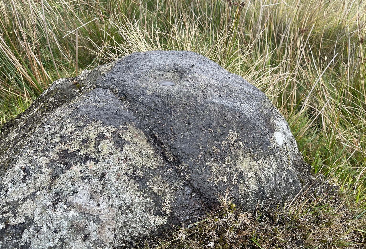
Single cupmark nr the top
On a recent visit to the Fraggle Rock carving, Tom Cleland foraged about at the edge of what was, in centuries gone by, a good flowing stream below the west slope of Reva Hill. An old pathway cut across one section of it near where the walling now runs, covered these days in the mass of Juncus reeds, typical of mashy grounds. And here, just where folk would cross the waters, Tom found a good sized stone with a single deep cup-mark on its crown, calling through a feast of lichens to be seen once more. There may be a second cup-mark by its side, but the light wasn’t good when we were here, so that’ll be worked out some other day. Anyhow, this one’s probably only for the crazy petroglyph hunters out there. It’s the Fraggle Rock and its companios that you’re gonna be looking for, nearby….
In Miss Maitland’s (1935) article on the Ledard Stone carving, she also made a brief mention of “another cup-marked stone (that) lies on the edge of the burn, beyond the one described, above Loch Ard.” She gave no further information about this second stone. It remains lost and sounds to be only a short distance further uphill and on the west-side of the burn. If any local explorers are able to find this carving please let us know and, if possible, add some info and photos of it on our Facebook page. (the grid-reference for this site profile is an approximation)
References:
Maitland, Mrs, “Cup Marked Stones”, in The Scottish Country Woman, 1935.
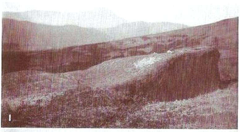
This carving hasn’t seen the light of day, seemingly, since it was first reported by a local lady, a Miss Maitland in the 1930s—and who, it transpires, uncovered a number of petroglyphs in this neck of the woods. She found it on one of her many forays in the mountains hereby and took some old photos of it—although they’ve not reproduced too well for the sake of the site profile. (apologies)
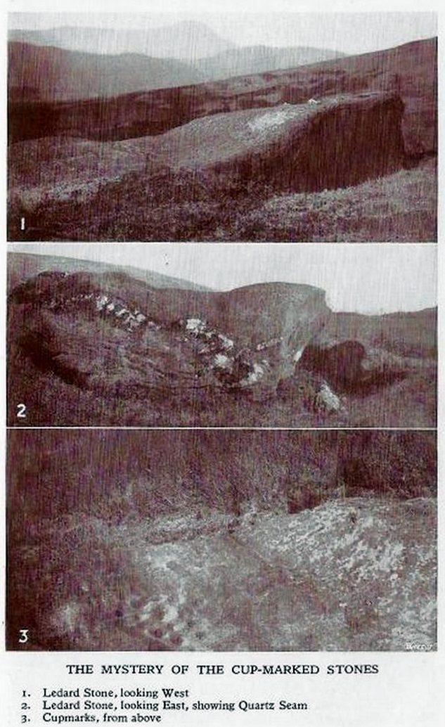
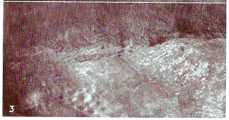
Since Miss Maitland’s days, the hillside has been covered in forestry plantation, making it extremely difficult to locate the carving. However, due to the reasonably large size of the stone, it should still be there (smaller cup-and-ring stones have been damaged and destroyed by forestry over the years); and as we can see in the middle photo, a long thick vein of quartz runs roughly along the middle of the stone—an ingredient which may have been significant for the people who carved the stone. In her article in the Scottish Country Woman magazine, Miss Maitland told:
cup-marks, bottom leftLedard Stone
“On the hill directly behind Ledard, on the north side of Loch Ard, a little to the west of the burn and a little to the east of the first grouse-butt, exactly 700 feet above sea level, lies a large boulder. Ice has smoothed and fashioned it and on the worn surface may be seen twenty-one, or so, small round hollows, varying in size and depth. The pattern made is roughly diamond-shaped, pointing directly east and west. I saw them for the first time as the sun was setting on New Year’s Eve, 1932. It was a solemn moment, for as far as I know no one else had looked upon them with such joy, and even awe, for perhaps a thousand years!”
She may have been right. And by the sound of her words, she’d certainly caught the petroglyph bug!
Anyhow, the carving doesn’t appear to have been seen since then. A “cup-marked boulder” was noted in the Royal Commission’s (1979) listings, but with no further details. We assume it must be the same carving, although they never visited it. It’s also possible that they were referring to another lost cup-marked stone a short distance further up the hill from here. If any local explorers are able to re-locate the carving, please let us know, and maybe add some info and photos of it on our Facebook page.
References:
Maitland, Mrs, “Cup Marked Stones”, in The Scottish Country Woman, 1935.
Royal Commission Ancient & Historical Monuments of Scotland, Archaeological Sites and Monuments of Stirling District, Central Region, Society of Antiquaries of Scotland 1979.
Cross (replaced): OS Grid Reference – SD 8936 2883
Archaeology & History
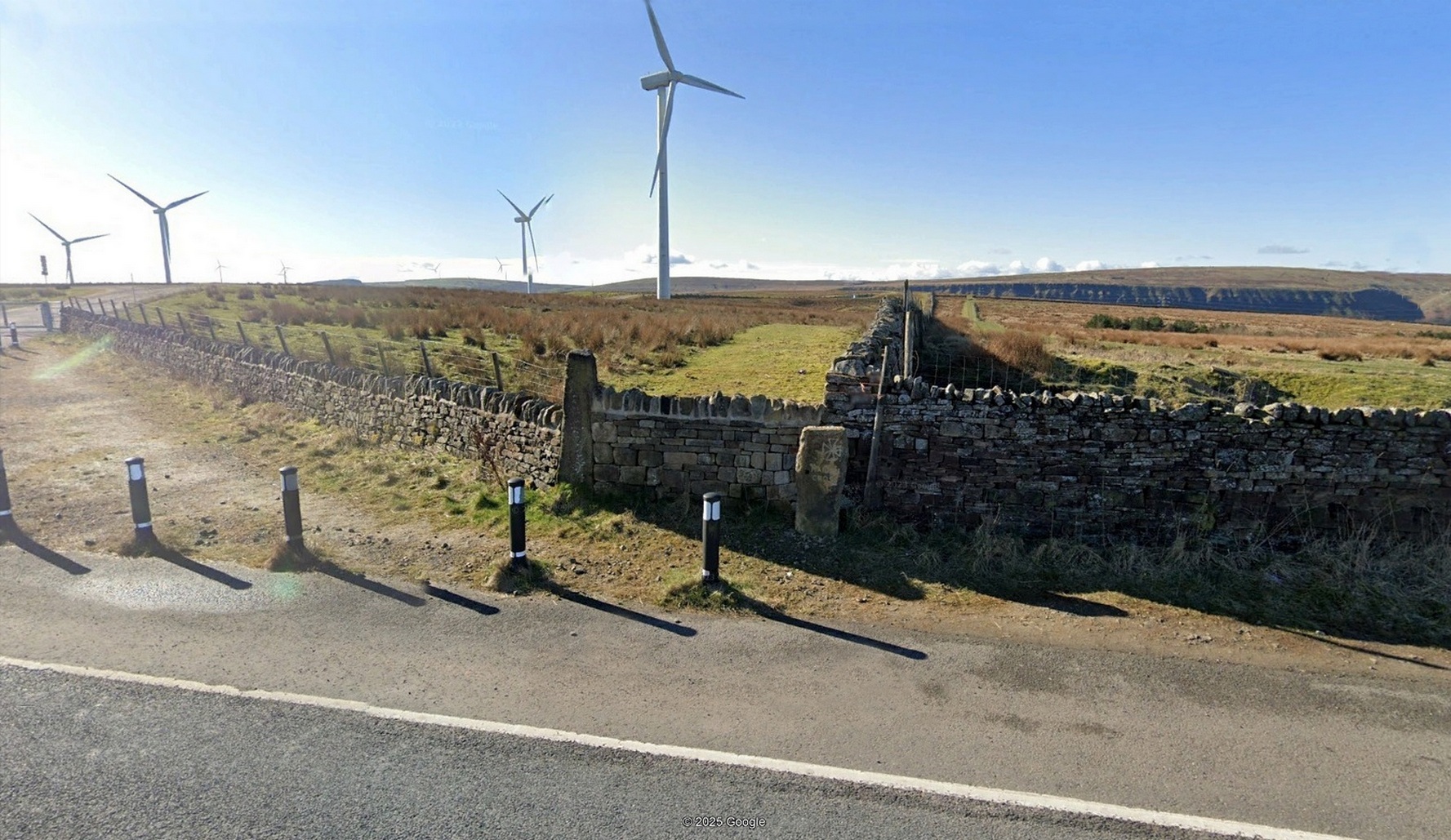
“Maiden Cross” stone
Highlighted on the 1848 Ordnance Survey map, the original stone ‘cross’ has apparently been moved from its location up against the walling 30-40 yards away and placed by the roadside, just as you’re going into where the windmills are, right at the very crown of the hill, across from the car-park. I’m not so sure it’s the original one to be honest—but I may be wrong. Clifford Byrne (1974) certainly thought this is the original stone. He may be wright. Byrne told that “the Marquis of Colne had a photograph of the stump of the cross in situ,” which would be good to compare. It’s nowt special to look at, but at least the site has been remembered, so to speak.
Site shown on 1848 map
The Maiden Cross was one in a series of wayside crosses along this ancient high road—known as the Long Causeway—not only marking it out when the snows covered it in the old Winters that we used to get, but also possessing religious importance to travellers. It was first moved sometime in the 19th century and “utilised as a gatepost into Maiden Cross colliery”—itself long gone.
Folklore
The name given to the ‘cross’ comes from a story that’s found at a number of other ‘maiden’ place-names. There may be an element of truth in it. It was told to the great historian and folklorist T.T. Wilkinson by his grandfather in 1766 and, according to him, his grandfather before that! J.A. Waddington (1884) subsequently wrote down the tale that Wilkinson told him:
“During the time of the great rebellion, this was the trysting-place of a young shepherd with his lady love. Often did they meet to pledge their simple vows at this lonely place, until one day a messenger came from Towneley to collect as many young men as he could get to swell the ranks of Rupert when he passed through this part to join the Royal forces at York, a march which ended with the disastrous fight at Marston Moor, on whose bloody sod lay stretched the chivalrous Towneley, and a many of his followers, including this young man, the victims of a tyrannical and ambitious king. For many a long year after this tragical event the poor demented maiden would repair to this hallowed spot, repeating with a sorrowful voice his promise to return.”
This was curiously described by Ormerod (1906) as “a pathetic tradition”! He much preferred the simple idea of this (and the other crosses along the road) as merely serving “the capacity of guideposts to the traveller (overtaken in a mist or by the swiftly lowering shades of light) who might be traversing these lonely roads”, as Waddington put it. Ormerod cited a conversation he had with “an old road mender” which for him confirmed the idea:
“Asked if he had heard what was the object of these crosses, he said, that “Joonas Lee said as they were put up 250 yer sin, for guideposts for’t pack horses, between Halifax and Brunshaw” (Burnley), adding, as if to give more weight to the authority he had quoted: “An he wur a far larned chap wur Joonas—he wur a preycher.”’
Walter Bennett (1941) meanwhile, thought its name derived from the Virgin Mary and this cross, at least, possessed religious importance.
References:
Bennett, W., The History of Burnley – volume 1, Burnley County Council 1946.
Byrne, Clifford, A Survey of the Ancient Wayside Crosses in North-East Lancashire, privately printed 1974.
Holden, Joshua, A History of Todmorden, Manchester University Press 1912.
Waddington, J. Arthur, ‘The Crosses in and Around Burnley’, in Transactions Burnley Literary & Scientific Club, volume 1, 1884.
Acknowledgements:Huge thanks for use of the Ordnance Survey map in this site profile, reproduced with the kind permission of the National Library of Scotland.
From Bainbridge, take the A684 road east to Aysgarth. Just out of the town, 200 yards over the bridge, take the right turn down Blean Lane. Nearly ½-mile along, take the minor road on your left and go along here for 1½ miles where, a few hundred yards before the solitary farm of Carpley Green (lucky buggers!), you can park up. (keep plenty of room for a tractor to get in the fields) Walk down the track past the farm and 250 yards along, where the first field ends, a gate leads you into the hills on your left. Go through here and then the next gate 120 yards on, then walk straight along th elong geological ridge ahead of you, veering to the top-side until it meets the walling. You’ll see the giant Stoney Raise cairn on the other side.
Archaeology & History
Stony Raise from above
The remains we find here are nigh-on immense! If giant cairns get you going (like the Great Skirtful of Stones or the denuded Devil’s Apronful near Pendle, etc), this one will blow you away! Along its widest axis, to this day it’s nearly 40 yards across and nearly 7 feet high! But in earlier times it was even bigger—much bigger! The first known description of the site was made by one Charles Fothergill, a Yorkshire-born politician and ornithologist, who wrote a diary of his walking excursions to various places in North Yorkshire at the beginning of the 19th century. (Romney 1984) His account of it was a good one for that period and thankfully he recorded information that would otherwise have been forgotten. After his visit here in September 1805, he told about this,
“wonderful tumulus called Stone raise which is a great curiosity: it is formed entirely of large stones piled up without earth or gravel, differing in that respect from any I have seen. Notwithstanding that upwards of a thousand, nay ’tis said several thousand, loads of stones have been led away from it to build walls with, it yet remains a stupendous monument of this species of antiquity: we measured the base of it as well as we could by our strides and made it 369 feet in circumference and of such an height as to be seen for a considerable distance. It has been most completely rifled…and it now presents a number of small craters formed by the investigations of the money searchers. It is situated upon a hill about half a mile south of Addlebrough. In addition to the particulars I formerly mentioned, I may say the men who first opened it about 50 years ago worked incessantly for 33 days. It stands on Thornton moor, and tho’ the Thornton men would not assist in the labour, they intended to share in the profit if there was any; but the adventurers who had all the work resolved they should not and they carried a large sword with them every day to defend the treasure in case they found any; the wise man who read ’till the stones shook and rattled was a schoolmaster at Bainbridge: the teeth they found were deposited in a hollow place in the bottom of the tumuli formed long and narrow like a coffin by a walling of stones. Tho’ the tumulus has apparantly been compleatly rifled, I do not believe the whole base has been sufficiently searched, but if it was to commemorate one great individual, which appears to have been the case, perhaps nothing more may be found.”
Fothergill’s description of “upwards of a thousand” cartloads of stone being removed from Stony Raise has been doubted by some archaeologists, but this claim should not be dismissed so lightly without evidence. There are immense tombs from northern Scotland to the unholy South that have remained untouched by the hand of industrialists that easily enter the category of such giants and this may have had equal stature.
A few years after Fothergill’s visit, Thomas Whitaker (1823) briefly described the site in his magnum opus, but added very little, simply telling that on the hills behind Addlebrough,
“there is still on that elevated spot a cairn, called Stone Raise, about 120 yards in circumference at the base, to which the usual tradition of its containing a treasure of gold having been attached, two persons were several years ago induced to make the experiment; but having penetrated to the centre, found, to their great disappointment, what an antiquary would have prepared them to expect, namely, a kist vaen of flag stones, with the remains of a human skeleton, the teeth of which were still pretty perfect.”
To this day the site remains unexcavated, so we don’t know too much about the place. It’s likely to have been constructed in neolithic times and its ancestral nature quite obviously venerated. It may have been re-used during the Bronze Age, but without excavations we may never know. A decent dig into this site is long overdue!
Folklore
This gigantic tomb is, not surprisingly, said to be haunted. Strange sounds and visions have been encountered here in bygone times. But the most well-known tale is that it was the site of a great treasure—perhaps hinted at by Fothergill. There are variations on the theme, but this is overall story:
Structured stonework
The tomb was said to be where a local giant had fallen and with him was buried a great chest of gold which he had dropped before he died. Some say that the ‘giant’ was a Brigantian chief – others a great warrior. The great treasure chest beneath the cairn is said to looked over by a fairy who lived by the giant’s tomb. It was this tale which gave the site its local name, the ‘Golden Chest on Greenber’. Several attempts made to find the treasure have all failed to uncover it.
However, by the time Edmund Bogg came to write of the place in 1908, the giant had by all accounts been found within! He told that,
The giant’s cist cover?
“this Kist-vaen was opened, many years back, and the skeleton of a chieftain of great stature was unearthed; the treasure chest of that or some other primal savage was not, and has not yet been discovered – for, take heed ye matter-of-fact money hunters, it is said the lucky one must first see the wraith of the ancient warrior to whom it belonged, who will then shew under which part of the immense Raise it is hidden! May this help any reader who is imaginative enough to find it – having seen the wraith he must keep silence – he has then but to stretch out his hand, and draw it forth.”
There are variations on this tale that have subsequently been penned by a number of Yorkshire folklorists, but this is the general lore. There was also a short rhyme told of toney Raise, that speaks of its apparent use through history by various races:
Druid, Roman, Scandinavia,
Stone Raise in Addlebro’.
References:
Bogg, Edmund, Wensleydale and the Lower Vale of the Yore, E. Bogg: Leeds 1906.
Bogg, Edmund, Richmondshire, James Miles: Leeds 1908.
Elgee, F. & H.W., The Archaeology of Yorkshire, Methuen: London 1933.
Gutch, Mrs E., Examples of Printed Folklore Concerning the North Riding of Yorkshire, David Nutt: London 1899.
Lofthouse, Jessica, Countrygoer in the Dales, Hale: London 1964.
Parkinson, Thomas, Yorkshire Legends and Traditions – volume 2, Elliot Stock: London 1889.
Pontefract, Ella, Wensleysdale, J.M. Dent: London 1936.
Romney, Paul (ed.), The Diary of Charles Fothergill, 1805, Yorkshire Archaeological Society: Leeds 1984.
Whitaker, Thomas Dunham, An History of Richmondshire – volume 1, Longman Hurst: London 1823.
White, Robert, A Landscape through Time, Great Northern: Ilkley 2002.
On the A816 road, a mile-and-a-bit north of Kilmartin, take the small road (east) to Ford—passing the Creagantairbh stone on your right, then a bit further on the Auchinellan stone on your left. Go through Ford village, making sure to stick to the road that goes along the north side of Loch Awe — as if you’re heading to Dalavich. Just fractionally over a mile out of Ford village, just where the road begins to swerve into a large bend, there’s a small left-turn that takes you to some houses. Just 60-70 yards along this little road, take the trivial little path on your right that takes you straight to a piece of manicured scrubland. If you walk into it, and bear left, you’ll see what you’re looking for. It’s unmissable!
Archaeology & History
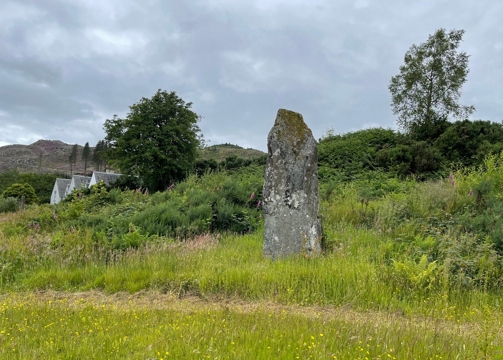
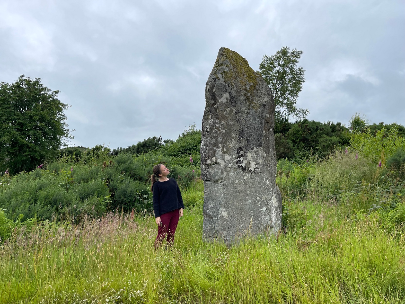
When I first visited here in the 1990s, a farm building stood by this huge standing stone and there were no other houses nearby. How things change—but thankfully our old sentinel stone is still living here.
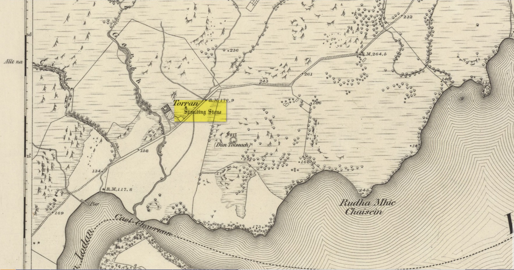
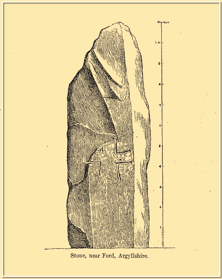
Site shown on 1875 mapRomilly Allen’s 1880 sketch
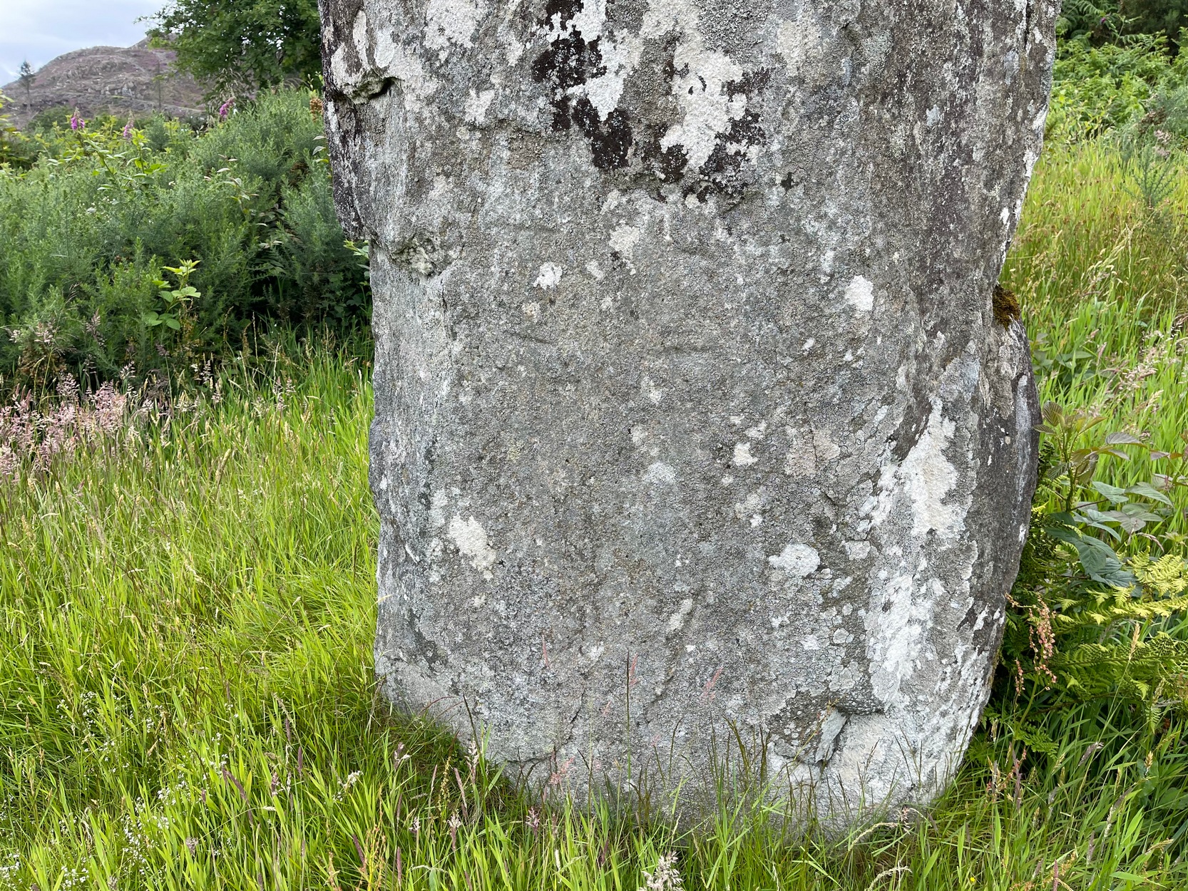
It was highlighted by the Ordnance Survey lads on their early map of the area, and visited a few years later by the great petroglyphic pioneer J. Romilly Allen. (1880) Standing eleven feet tall and more than four feet across at the base, Allen noticed that, about four feet above ground-level, someone had carved an old cross onto the northeast face of the stone (you can just make it out in the attached photos). It had obviously been carved many centuries ago, by a wandering christian no doubt—although it was incomplete and never finished. Perhaps the person who carved it was chased away by local folk, who would have obviously and rightly seen such an act as outright vandalism. The cross was deemed by Ian Fisher (2001) and the Royal Commission (1992) to be medieval in nature. Apparently there’s another, much fainter cross that was first mentioned by Marion Campbell etched on the other side of the stone, but in all the times I came here I was never able to make it out.
Old faint cross carvingSmall person, big stone!
But even further back in time someone had carved a cup-marking on the stone—and the cross was etched onto the same spot, enclosing the cup-mark. When I lived nearby, I made a sketch (long since lost) of what seemed to be two other faint cup-marks at one end of the extended arms of the cross, but on our recent visit here these were very hard to make out. When Ron Morris (1981) mentioned the stone in his survey, he mentioned its proximity to other cup-and-ring carvings immediately to the southeast and a hillock thereby, wondering whether there was “an astronomical complex” going on here. I doubt it—but I like the idea!
But it’s the size of the stone that’s most impressive here and keeps up with the tradition of similar megaliths in and around the Kilmartin area. Check the place out when you’re hunting the other stones nearby. You won’t be disappointed!
Folklore
Local tradition ascribed this great stone as marking the grave of an ancient warrior. The full folk tale seems to have been lost.
Fisher, Ian, Early Medieval Sculpture in the West Highlands and Islands, RCAHMS: Edinburgh 2001.
Morris, Ronald W.B., The Prehistoric Rock Art of Southern Scotland, BAR: Oxford 1981.
Royal Commission on the Ancient & Historical Monuments of Scotland, Argyll – Volume 6: Mid-Argyll and Cowal, HMSO: Edinburgh 1988.
Royal Commission on the Ancient & Historical Monuments of Scotland, Argyll – Volume 7: Mid-Argyll and Cowal: Medieval and Later Monuments, HMSO: Edinburgh 1992.
Ruggles, Clive, Megalithic Astronomy, BAR: Oxford 1984.
Swarbrick, Olaf, A Gazetteer of Prehistoric Standing Stones in Great Britain, BAR: Oxford 2012.
Acknowledgements:Huge thanks for use of the Ordnance Survey map in this site profile, reproduced with the kind permission of the National Library of Scotland.
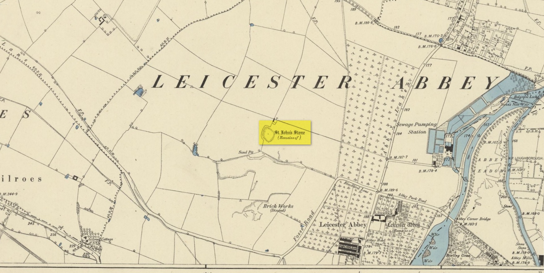
Standing Stone (destroyed): OS Grid Reference – SK 5779 0644
Also Known as:
Little John’s Stone
Archaeology & History
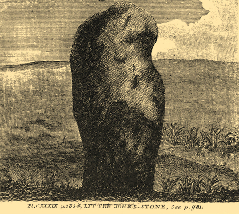
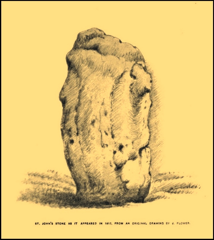
Nichols 1804 drawing
This once impressive megalithic site was first mentioned in 1381, giving its name to the field Johnstone Close. Shown on the early Ordnance Survey maps standing on a raised portion of land in an area north of the modern town centre, not far from the Abbey, its destruction had been a slow one until it finally disappeared about a hundred years ago. One of the early descriptions of it was by John Nichols (1804) in his immense series of works on the county. He called it ‘Little John’s Stone’* and gave us the first known illustration of the monolith (right), telling it to be “7 feet 2 inches high, and 11 feet 3 inches wide”—although he obviously meant circumference and not ‘wide’, as his illustration clearly shows. Although this slight error was perhaps the reason that Historic England proclaimed the stone to have been little more than “a natural feature”—which it clearly wasn’t.
Stone shown on 1885 mapJohn Flower’s 1815 sketch
The stone stood in what Nichols called “a kind of amphitheatre”, and what James Hollings (1855) subsequently called a sloping hollow which, he thought, had “been excavated by the hand of man.” It was located “in a meadow, a little to the west of the Fosse-way,” he said, “not far from the ancient boundary wall of the Abbey of St. Mary de Pratis.” There’s little doubt it was a prehistoric standing stone. Hollings described it as standing erect and told it to be one of those “monolithic erections, or hoar stones, anciently sanctified by the rites of Druidic worship,” comparing it to “similar rude columns” in Cornwall, Scotland and just about everywhere! He also told that it was a place of summer solstice gatherings, being
“in the memory of many living, annually visited about the time of Midsummer by numerous parties from the town in pursuance of a custom of unknown antiquity.”
When James Kelly (1884) wrote about the stone, little was left of it save at ground level. He repeated much of what Hollings had previously written, but had a few notes of his own. One related to the local mayor and MP for Leicester, Mr Richard Harris, dated January 1853, who told him:
“When a boy, he had frequently played on the spot where it was customary for the children to resort to dance round the stone (which he thought was about eight feet high), to climb upon it and to roll down the hill by which the stone is in part, encircled. The children were careful to leave before dark, as it was believed that at midnight the fairies assembled and danced round the stone.”
More than fifty years later when Mrs Johnson (1906) wrote about the place she said that only a small section of the stone still remained, just “a few inches above the earth.” It had been incrementally “broken to pieces down to the surface of the ground and used to mend the road.” (Kelly 1884) Alice Dryden (1911) lamented its gradual demise in size, summarizing:
“At the beginning of the nineteenth century it was about 7 feet high, but by the year 1835 it had become reduced to about 3 feet. In 1874, according to the British Association’s Report, it was about 2 feet high, and it has now completely disappeared.”
Local tradition tells that some small pieces of St John’s Stone were moved to the nearby St. Luke’s church, where bits of it can still be seen. Has anyone found them?
More recent lore has attributed St John’s Stone to have been aligned with the Humber Stone (SK 62416 07095) nearly 3 miles to the east, in a summer solstice line—but it’s nowhere near it! A similar astronomical attempt said that the two stones lined up with the Beltane sunrise: this is a little closer, but it still doesn’t work. The equinox sunrise is closer still, but whether these two stones were even intervisible is questionable.
* this was probably the name it was known by local people who frequented the nearby Robin Hood public house (long gone); its saintly dedication being less important in the minds of Leicester’s indigenous folk.
References:
Cox, Barrie, The Place-Names of Leicestershire – volume 1, EPNS: Nottingham 1998.
Devereux, Paul, “The Forgotten Heart of Albion,” in The Ley Hunter, no.66, 1975.
Dryden, Alice, Memorials of Old Leicestershire, George Allen & Sons: London 1911.
Hollings, James Francis, Roman Leicester, LLPS: Leicester 1855.
Kelly, William, Royal Progresses and Visits to Leicester, Samuel Clarke: Leicester 1884.
Nichols, John, The History and Antiquities of Leicestershire – volume 3: part 2, J. Nichols: London 1804.
Trubshaw, Bob, Standing Stones and Markstones of Leicestershire, Heart of Albion Press 1991.
Acknowledgements:Huge thanks for use of the Ordnance Survey map in this site profile, reproduced with the kind permission of the National Library of Scotland.