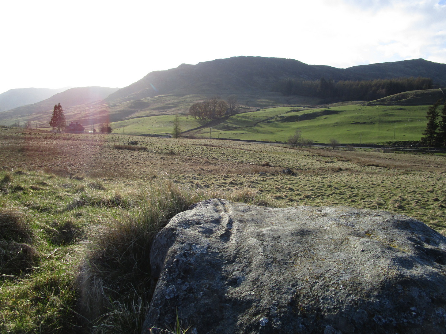
From Pitlochry town centre, walk down the A924 high street as if you’re going to the Blair Atholl Distillery, but just before it take the right-turn and go over the river, and just keeping walking along this road for a third-of-a-mile (0.5km) until your reach a small small on your left that swerves up the hill (there’s a little signpost here saying Cluny Path to Strathtay). Go up and across the main road, then just keeping walking up the dirt-track, which becomes a footpath, and heads further uphill into and through the woodland. Make a bittova daydream from the walk up here, making sure to keep to the path closest to the burn (stream) on your left. Eventually when it levels out, you’re very close. Just keep on the same track and, where it meets up with another, bear left and about 100 yards along, on a small rise in the trees on your right, you’ll see these old stones peeking out. Keep your wits about you!
Archaeology & History
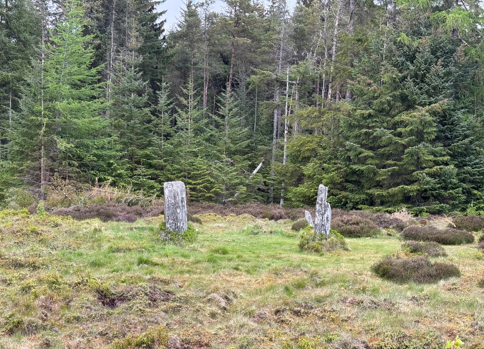
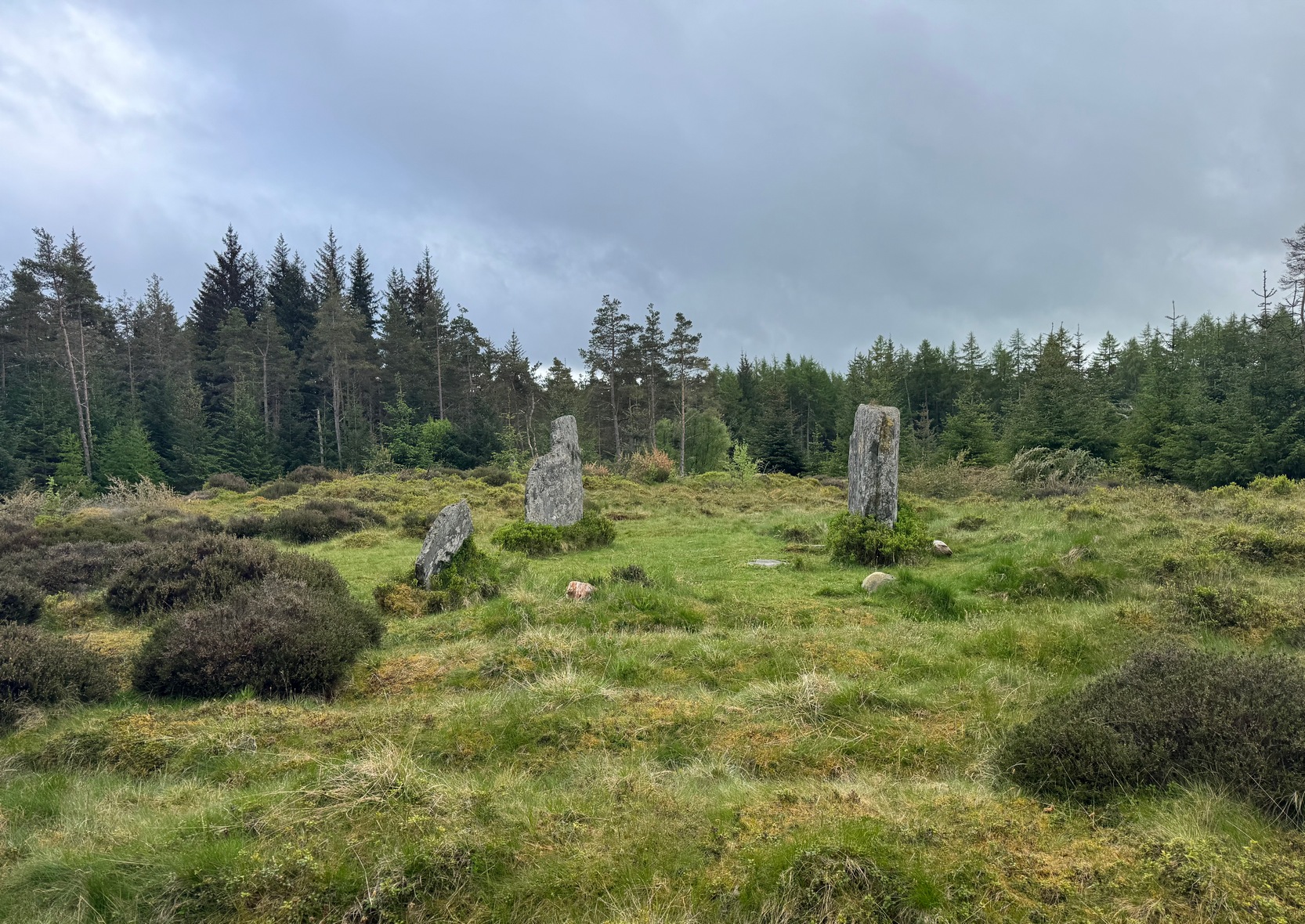
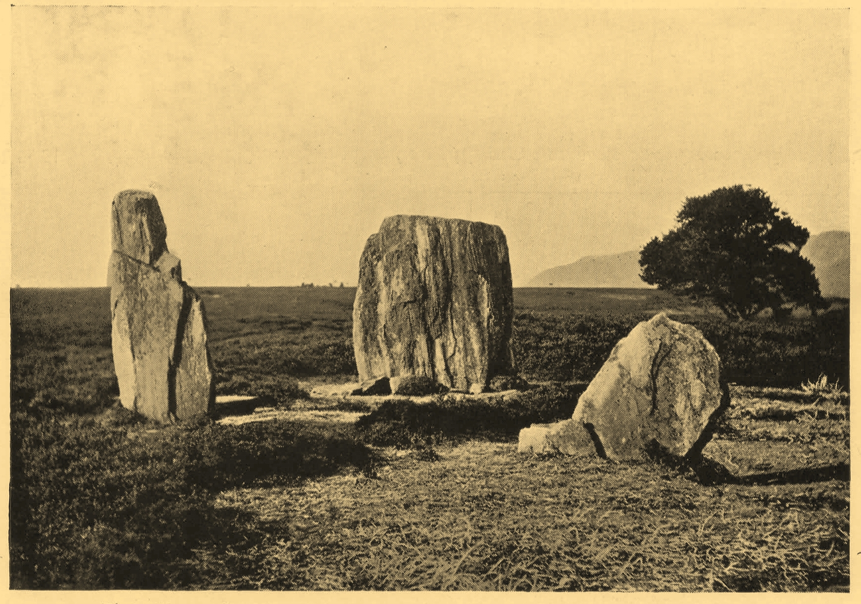
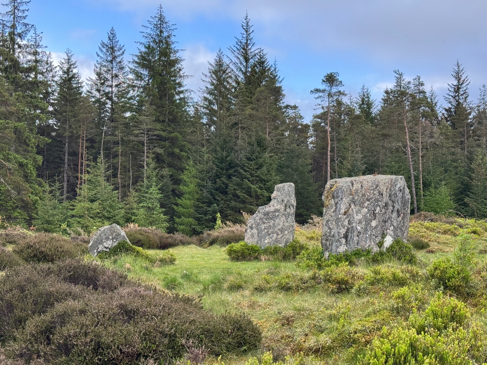
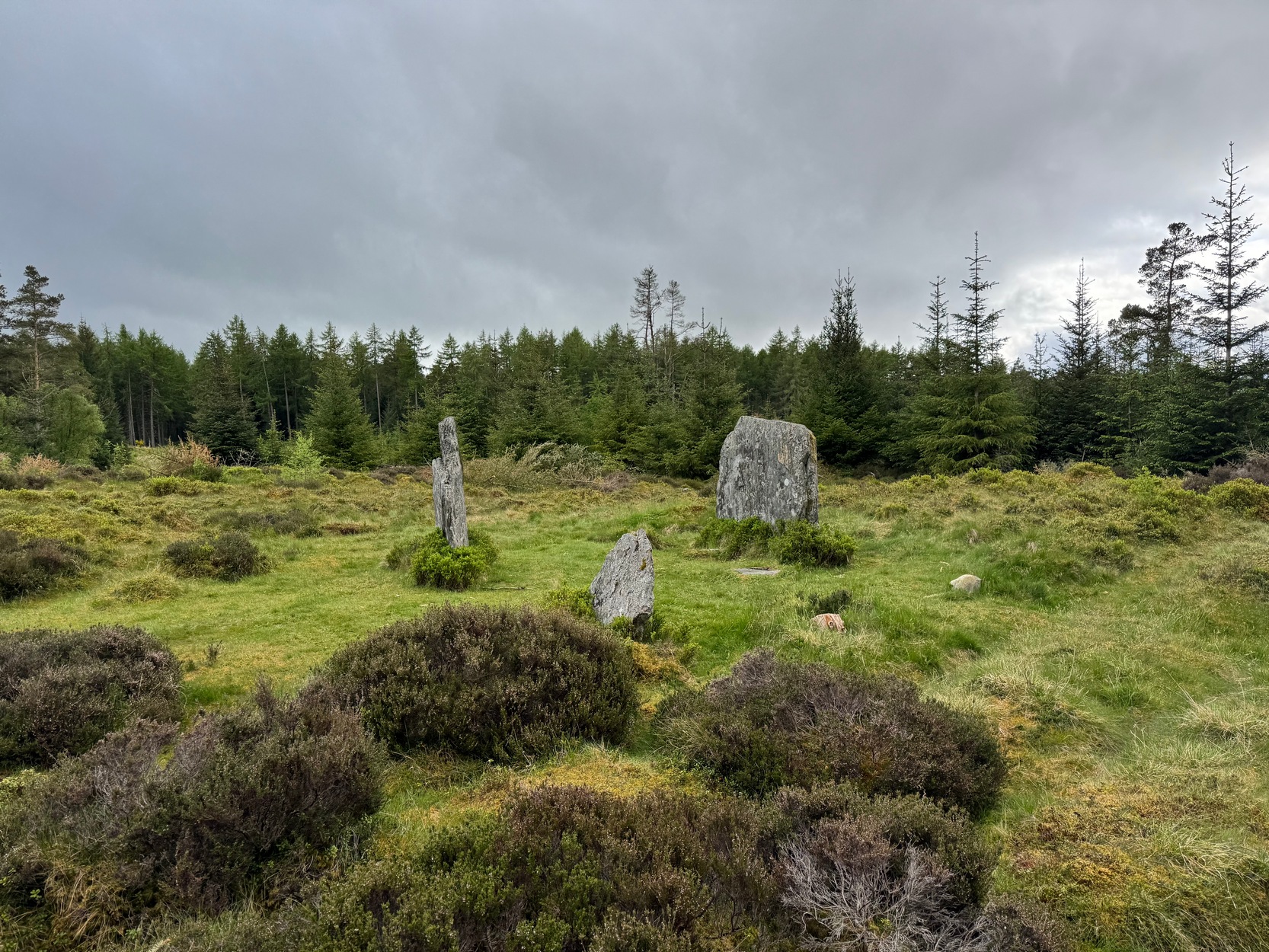
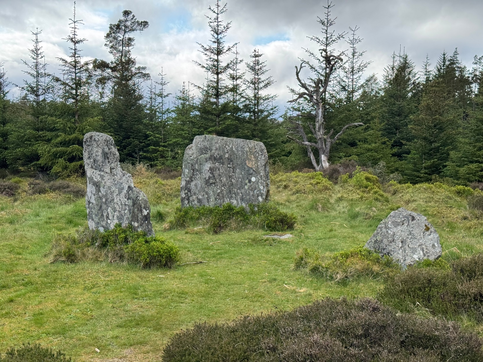
Clachan an Diridh looking E
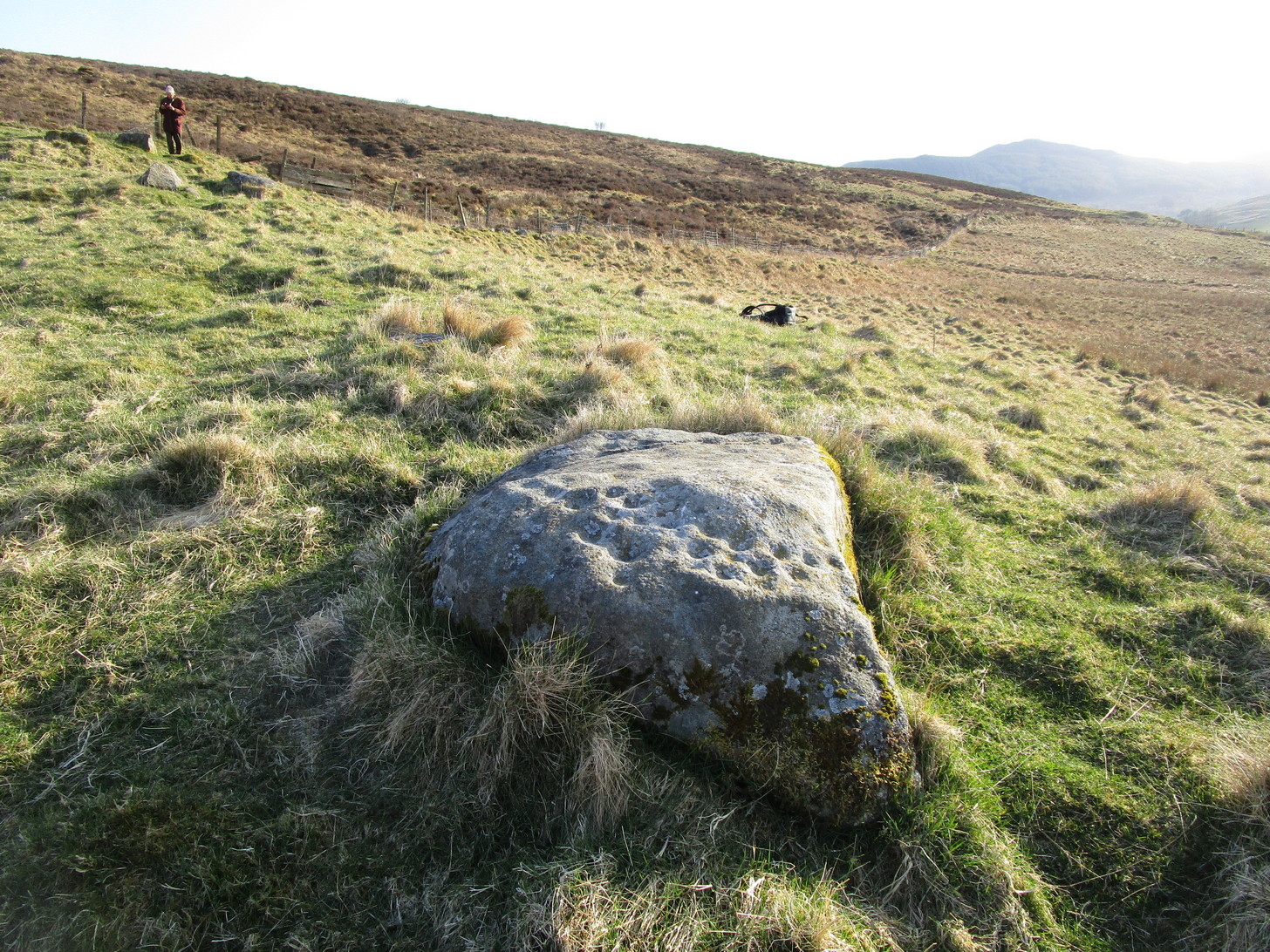
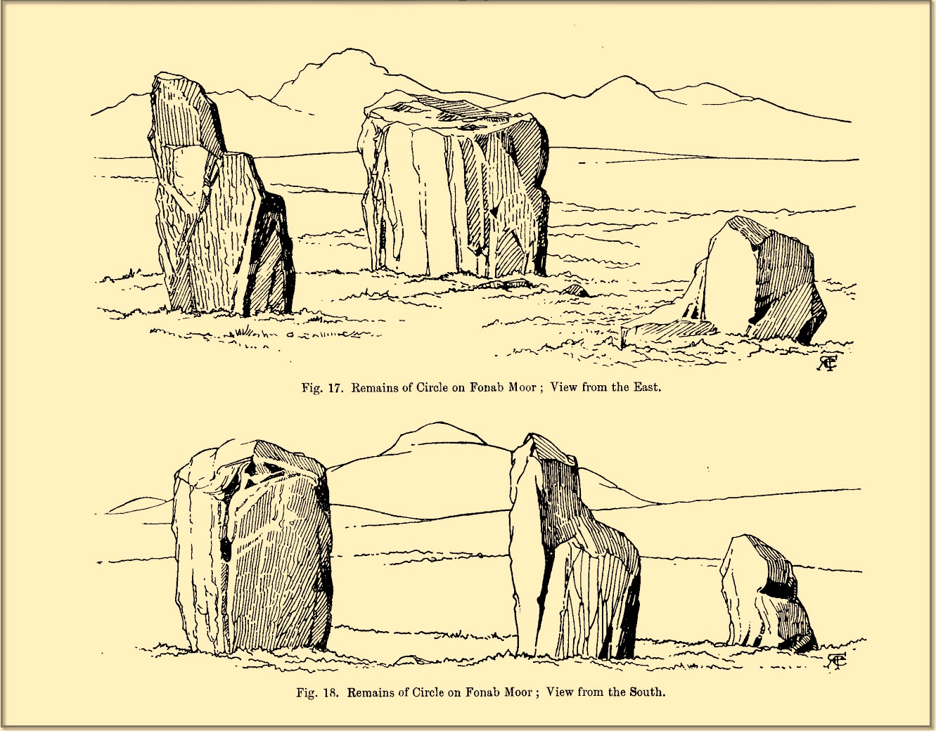
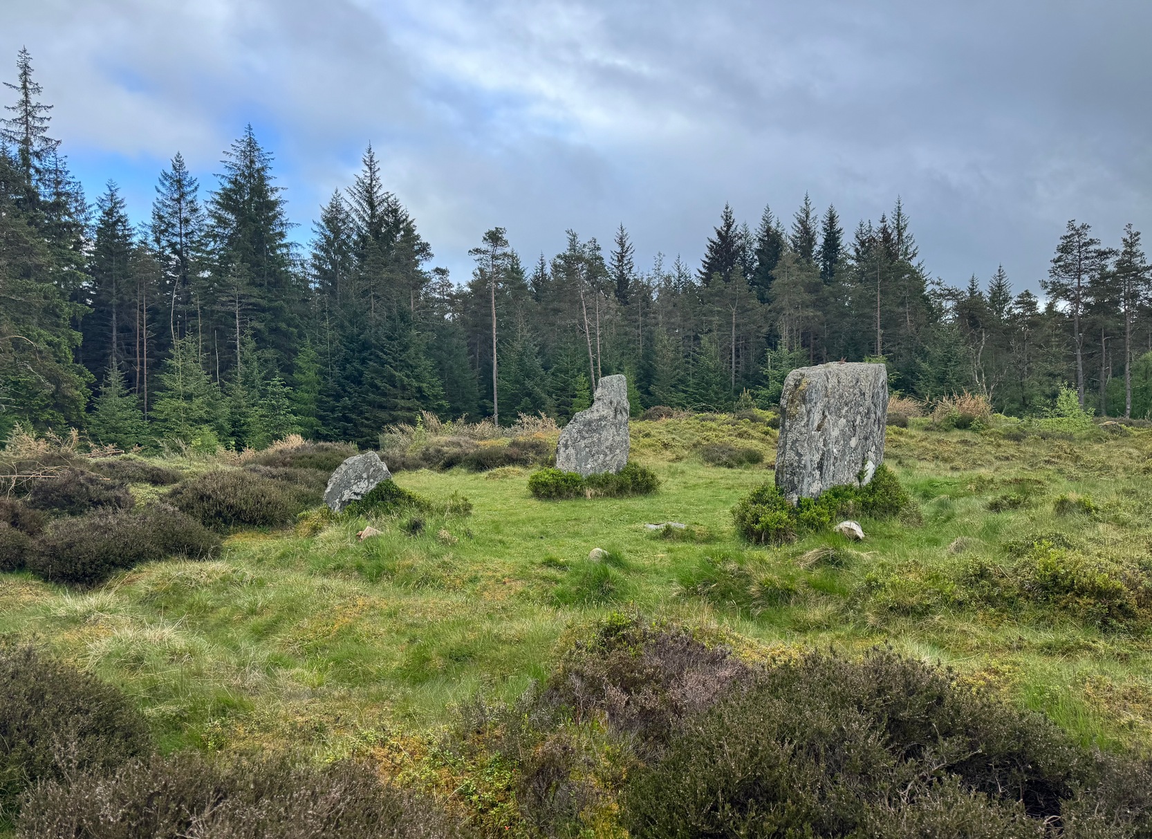
Sat high up on open moorlands with views all round… is what this site used to look like. Sadly, the forestry commission have almost completely enclosed this prehistoric site, making any view of the surrounding landscape all but impossible. I’m not the first and won’t be the last person to be pissed-off by such thoughtlessness. Alexander Thom made mention of it too. After making an initial assessment of the astronomical alignments at these stones in 1967, “when we returned to measure the horizon we found that trees had been planted round the stones and so we failed.” (Thom 1990) Not good.
On my first visit here, as I entered this “stone circle” my first impression was that it wasn’t a circle at all, but the remnants of a megalithic stone row! Thom thought the same. It’s the slender thin stature of the stones that do it to you: they almost cut the air and point the enquiring nose dead straight along the same angle that all the stones have been deliberately aligned to. I assume they’ve had a similar effect on other people over the years.
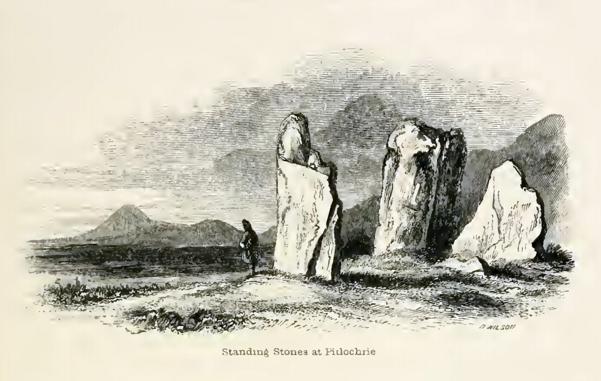
The Clachan an Diridh, or the Stones on the Ascent, were first mentioned in Dan Wilson’s (1851) major survey and who was so impressed by the view from here and its setting in the landscape that he compared its visage to Stonehenge. Were it not for the short-sightedness of the Forestry Commission destroying the view, most would no doubt agree with Wilson’s sentiments. From these olde stones, he told:
“One of the great level Highland moors stretches away beneath the eye, like a dark waveless lake, contrasting with the distant heights, among which Ben Lawers rears its pyramidal summit to an elevation of upwards of 4000 feet above the level of the sea. Amid this wild Highland landscape the huge standing stones, grey with the moss of ages, produce a singularly grand and imposing effect; and from the idea of lofty height which the distant mountains suggest, they convey a stronger impression of gigantic proportions than is produced even by the first sight of the giant monoliths of Salisbury Plain.”
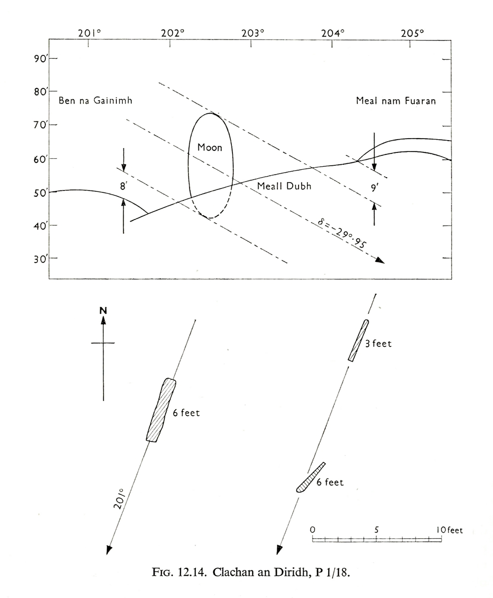
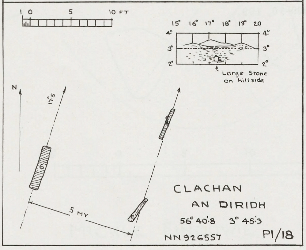
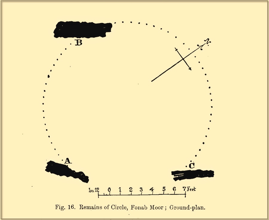
Thom’s initial moonset alignmentThom’s 1980 ground-plan with marker stone
The giant figure of Ben Lawers, if we could see it today, would rise to the southwest 20 miles (32km) from here; and the great pyramidal fairy mountain of Schiehallion would be equinox west, 13 miles (21km) away. Yet curiously when Alexander Thom surveyed the outlying hills, he didn’t think either of these mountains had any worth, astronomically speaking that is. Yet Lawers in particular would be the largest point on the southwestern horizon, rising in the distance, way beyond the wide rolling U-shaped glen of Strathtay to where the landscape changes into more rugged dynamic uplands. And the importance of Lawers as a place in prehistory is shown by the mass of petroglyphs across its slopes—particularly the side you could see from Clachan an Diridh.
Instead, Thom (1967) looked much further to the southwest—south-southwest in fact—where he initially thought that there was an alignment to the major southern moonset ten miles away above the rugged hill of Meall Dubh, framed on either side by the mountain peaks of Meall nam Fuaran and Beinn na Gainimh. Aubrey Burl (1988) told how Thom later discounted this alignment and instead turned his attention a full 180° where a large stone on the hillside to the north-northeast caught his theodolytic eye. This marked an alignment towards the peak of Ben Vrackie:
“There is little doubt,” he wrote, “that this is a lunar site showing perhaps…at the major standstill. Could one side of the southern 6ft high stone possibly have indicated the setting point of the Moon at minor standstill?” (Thom 1990)
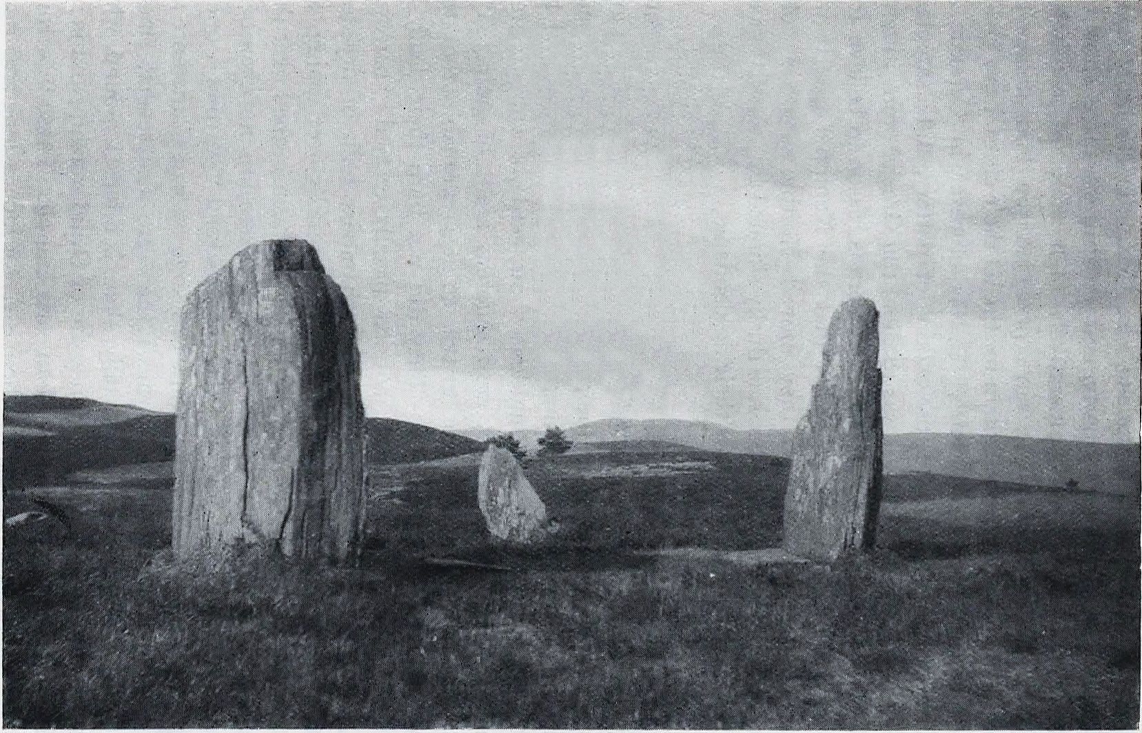
Clachan an Diridh in 1851Clachan an Diridh, c.1920
Thom looked at these stones and the landscape with the mind of an astronomer, whereas I’m more in preference of the aborigine who sees the feel of the landscape to discern relationships and meanings. Sometimes, of course, the sky and the landscape come together and that universal mythic union of heaven and Earth finds importance at a site. I have little doubt that such a mythos was once known here, on the moorland plateau, under the clear stars with the darkness reaching to speak with Lawers and other bones of landscape in the solid darkness of mountain silhouettes and fading horizons. Many a sleep at this site would have touched minds with Wonder…
Anyway, all that aside…
Large fallen stoneSite on the 1899 OS-map
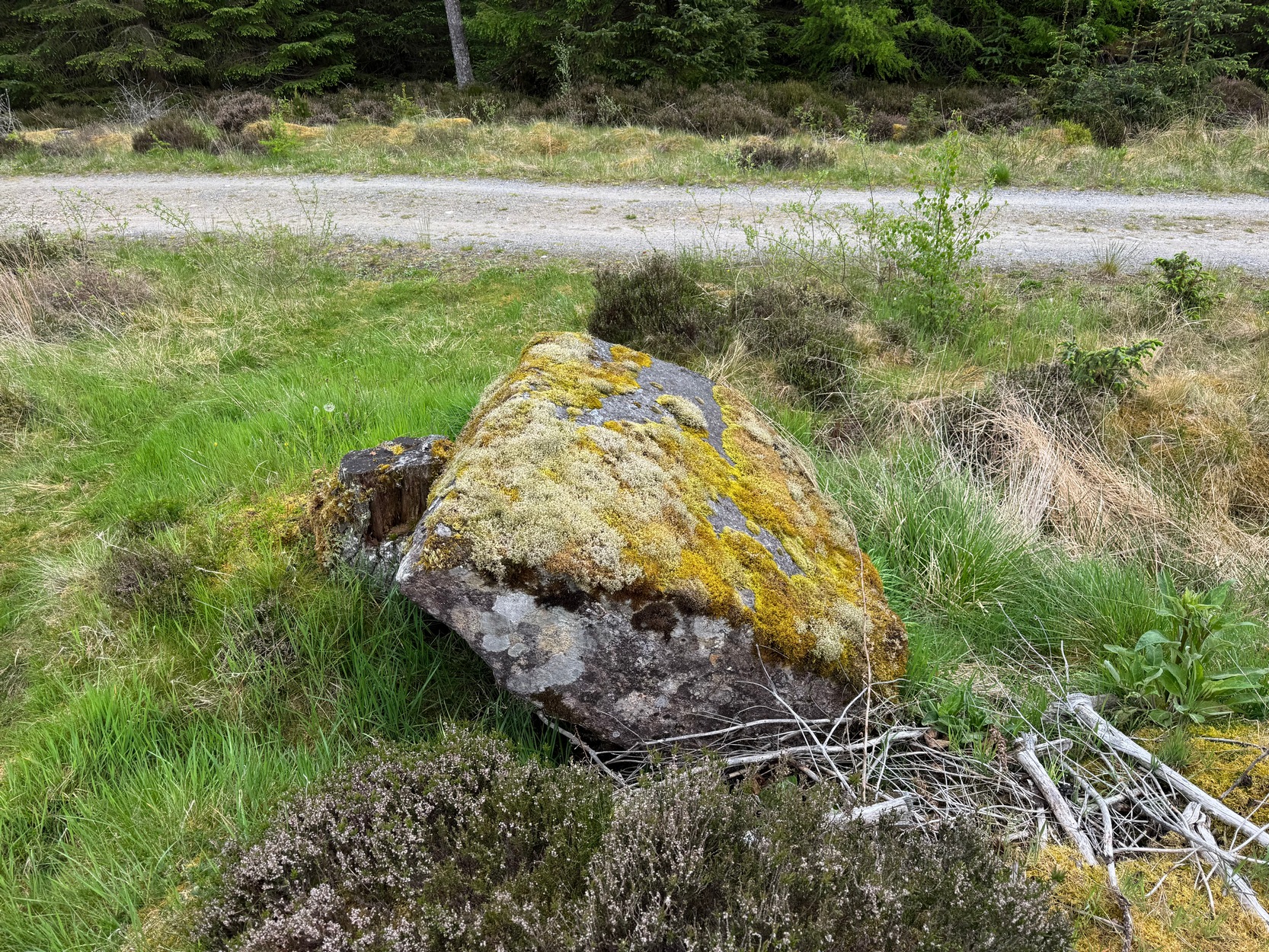
These megaliths have been classified as one of Aubrey Burl’s “four posters”, i.e., a rough square of four megalithic uprights, in spite of there only being three standing stones here. Even when Dan Wilson (1851) wrote about the place there were just three of them. However, down the slope from the stones, just off the recent trackside, there’s a decent contender for the fourth stone lying on its side in the undergrowth, half-covered in moss. It’s certainly fallen or rolled down the slope and its size and shape suggest that it may once have stood upright. Have a thoughtful fondle of it while you’re here.
The ‘circle’ was highlighted on the 1899 OS-map and, a few years later, was visited and surveyed by the great Fred Coles (1908) and like Dan Wilson before him, told the view from here to be “very grand.” He continued:
Coles 1906 planColes’ views, from S & E
“In local parlance this group is known as the Four Stones. This must be a fairly old name handed down through some generations; because, for at least fifty-seven years past, only three Standing Stones have remained in situ. These three Stones are arranged as shown in the plan…in a group forming in its now imperfect condition a triangle which, measured from the centres of the Stones, has its SE side 11 feet 6 inches long; its SW side 12 feet 3 inches ; and its north side 16 feet 3 inches. Fragments of the demolished fourth Stone lie about the ground; but there is no clear indication of its original position. The South Stone, A, is 3 feet 7 inches in breadth, 5 feet 10 inches in height, and from 12 to 4 inches in thickness. The West Stone, B, 6 feet in height, measures 5 feet at the back, and 4 feet 10 inches at the front, and is 18 inches in thickness. The East Stone, C, at its outer angle is 3 feet 3 inches above ground, and leans inward. All the blocks are of quartziferous gritty sandstone, the East Stone being particularly rough and fissured. A large fragment lying near it seems to be a portion of it. The Stones are set upon a fairly true Circle with a diameter of 15 feet 4 inches. One feature quickly arrests notice: this is, that the broader faces of these Stones are not set even approximately upon and in line with the circumference, but nearly parallel with each other—an arrangement quite unlike the setting of Stones in the many other Circles hitherto surveyed.”
When Burl (1988) added this site to his Four Posters survey he merely echoed Coles’ early description, adding that, in his view, the standing stones that we see today were probably, originally, “set out on the circumference of a circle 20ft (6.1m) in diameter.”
I think it’s likely that there would have been more prehistoric sites in the vicinity, but a notable oddity is the almost complete absence of other recorded sites anywhere nearby. Of course, if there was anything, those thoughtful Forestry Commission heads would have destroyed it. We are left, simply, with the old but reliable notes of Messrs Dixon (1923) and Mitchell (1925) who told that, in their days, other remains did exist nearby in the form of ancient cairns and hut circles—‘Pictish’ according to tradition. If we’re lucky, some damaged parts of them might still be found at the edges, a short distance to the north west…
Folklore
In Hugh MacMillan’s (1901) gorgeous literary sojourn along Strathtay, he strayed somewhat from his otherwise historical notices by telling that here,
“on the highest part of the moorland…is a group of ‘clachan iobairt’, or stones of worship, where the Druids of old performed their mysterious rites, going round the circle of standing stones from east to west with the sun, or the ‘car deasal’, the lucky side, when they wished to invoke a blessing upon their friends, and going round the circle in the opposite direction, from west to east, the ‘car tuathsel’, or unlucky side, when they wished to pronounce a curse upon their foes.”
Whether this was what Hugh Mitchell (1923) meant when he referred to the traditions surrounding Clachan an Dirirdh we don’t know, but he echoed MacMillan’s account (though made no reference of his words), also adding that it was a site that “was visited on the first of May” or Beltane by some local people….
References:
Burl, Aubrey, Four Posters: Bronze Age Stone Circles of Western Europe, BAR 195: Oxford 1988.
Burl, Aubrey, A Guide to the Stone Circles of Britain, Ireland and Brittany, New Haven & London 1995.
Burl, Aubrey, The Stone Circles of Britain, Ireland and Brittany, Yale University Press 2000.
Dixon, John H., Pitlochry, Past and Present, L. Mackay: Pitlochry 1925.
Kennedy, James, Folklore and Reminiscences of Strathtay and Grandtully, Munro Press: Perth 1927.
Liddell, Colin, Pitlochry – Heritage of a Highland District, PKDL: Perth 1993.
MacMillan, Hugh, The Highland Tay: From its Source to Dunkeld, H. Virtue: London 1901.
Mitchell, Hugh, Pitlochry District: Its Topography, Archaeology and History, L. Mackay: Pitlochry 1923.
Omand, Donald (ed.), The Perthshire Book, Birlinn: Edinburgh 1999.
Stevenson, J., “Prehistory,” in Omand’s The Perthshire Book, Edinburgh 1999.
Thom, Alexander, Megalithic Sites in Britain, Oxford University Press 1967.
Thom, Alexander, Megalithic Lunar Observatories, Oxford University Press 1971.
Thom, A., Thom, A.S. & Burl, H.A.W., Megalithic Rings, BAR: Oxford 1980.
Thom, A., Thom, A.S. & Burl, Aubrey, Stone Rows and Standing Stones – volume 2, BAR: Oxford 1990.
Wilson, Daniel, The Archaeology and Prehistoric Annals of Scotland, Sutherland & Knox: Edinburgh 1851.
Acknowledgements: Huge thanks for use of the Ordnance Survey map in this site profile, reproduced with the kind permission of the National Library of Scotland.
Holy Well (destroyed): OS Grid Reference – NN 9397 5770
Archaeology & History
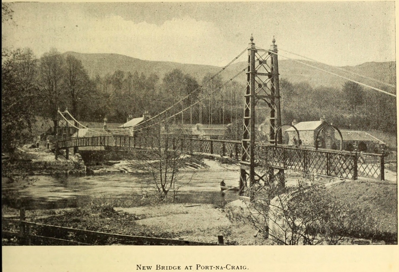
It was more than a hundred years ago that the waters of this sacred well fell back to Earth. They emerged above the eastern side of the River Tummel, close to the bridge where previous there had been a local ferry at the site known as Port-na-Craig. The mythic history of the ferry and the holy well went hand-in-hand, according to local tradition. Its lore was was spelled out by the local author and historian Hugh Mitchell in a speech he gave when a new bridge was opened here in 1913. He said:
The Well was on the far side of the bridge
“The ferry at Port-na-Craig, though not as old as many ferries in Scotland, bears the respectable antiquity of something like eight hundred years. It was established by the monks of Coupar Angus when they got a gift of the lands of Fonab, and as Coupar Angus lay on the north side of the river Tummel, they established the ferry in order to have communication. In those days the ferry boat was made of skins stretched on branches or twigs, so it was somewhat dangerous to cross in, and the monks thought that they would improve the occasion by dedicating the well near the old ferry to St. Bride, so that people, when they ventured across the ferry, might propitiate the saint. It was customary for people to drop either a small coin or a brass pin into the well. He was afraid that brass pins rather prevailed, and no doubt, St. Bride, being a lady, would find them more useful. The well remained until recent times, when it had, unfortunately, to be filled up, on account of being contaminated by neighbouring fields.”
For “fields”, read sewage—for that was the actual reason it was closed. Mr Mitchell (1923) told as much in his subsequent history of Pitlochry, saying that “sewage was percolating into it.” John Dixon (1925) echoed the same thing a few years later.
The curative and magickal properties of St Bride’s Well had considerable renown for local people. Mitchell told that:
“It had a great reputation at one time for cases of lung disease… Pins and coins were dropped into the well as votive offerings, and the bushes above it were hung with rags to call the attention of the saint to the sufferer.”
A few miles north from here, at the back of Blair Castle, an old church is dedicated to St. Bride, whose celebration date is February 1. “The day was known as Candlemas in the Highlands,” wrote Mrs Banks, saying, in commemoration of the Celtic Brigit, “Feill Bride, the festival of Bride, displaced the festival of Mary.”
References:
Dixon, John H., Pitlochry, Past and Present, L. Mackay: Pitlochry 1925.
MacKay, L., Atholl Illustrated, L. MacKay: Pitlochry 1912.
Mitchell, Hugh, Pitlochry District: Its Topography, Archaeology and History, L. Mackay: Pitlochry 1923.
Cup-Marked Stone (lost): OS Grid Reference – NO 003 650
Archaeology & History
When you’ve visited the impressive cup-marked stone at Dalnavaid, this long lost carving might be worth seeking out by the real explorers among you. It’s not been seen for a hundred years and was only reported in brief by the reputable local historian Hugh Mitchell (1923). It’s located a mile north of the Dalnavaid carving, up in the hills on the other side of the road, “on the East side of Clunskea Burn, and on the West shoulder of Ben Skievie.” He described the carving as “having some 16 or 18 cups, and at present it forms part of a grouse butt.”
So if we locate the grouse-butt (they’re usually not too difficult to find), the carving will obviously follow. Mitchell gave us an extra piece of info regarding its location. He described the existence of several other seemingly prehistoric remains within a few yards of the grouse-butt, curious “pit dwellings”, three of them:
“they are of circular shape, about 9 feet in diameter and nearly 5 feet below the surface of the ground, and had evidently been roofed over at one time. The entrance to each is at the lowest level and acts as a drain, to keep the house dry. They are almost the only examples in the district of neolithic dwellings.”
Let us know if you find it!
References:
Mitchell, Hugh, Pitlochry District: Its Topography, Archaeology and History, L. Mackay: Pitlochry 1923.
The quickest and easiest route is to take the A924 road from Pitlochry to Kirkmichael. It’s a gorgeous route in itself! Anyhoo… Once you’re out past the houses of Pitlochry and Moulin, you begin to make the real ascent up the winding road, past the hairpin bend and, 5 miles up where the road has levelled out and the craggy moorlands surround you, green fields begin to appear on your left. The first farm on your left is Dalnacarn and less than a half-mile past here, on your right, a small track takes you to Dalnavaid house. Walk along here, past the house and into the field, then the next field where a section rises up towards the fencing. On top of this are several rocks. You can’t really miss it!
Archaeology & History
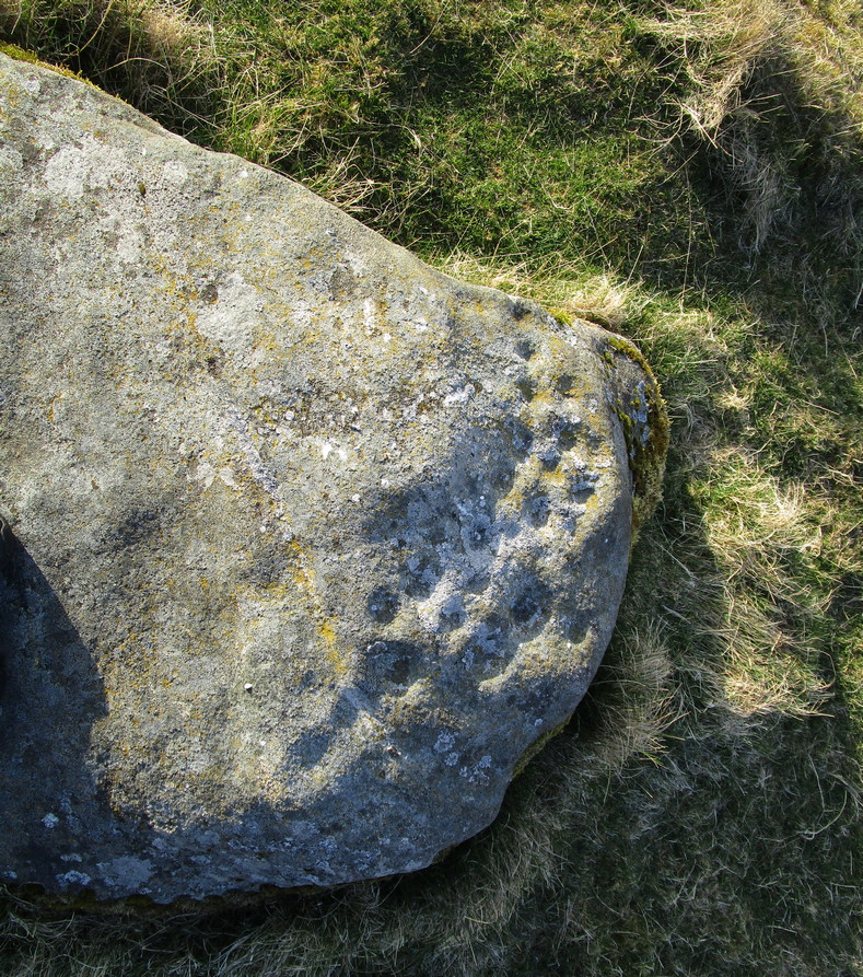
This typically female rounded rock has, unusually, a series of cups in almost three rows along its easternmost slope, with one or two single cups on its top and southern side. It was first described by Fred Cole (1908) merely as “a small boulder, with a remarkable triple row of cup-marks, resting on a cairn-like mound”; but it wasn’t until John Dixon (1921) came here that a full description appeared. He told us,
Primary rows of cupsLong worked (?) line
“About 200 yards due east of (Dalnavaid) house a ridge or spit of land juts out from the adjoining hillside on to an almost level field. The ridge has sloping sides, and the nearly flat top is 10 or 12 feet above the general surface of the field. Near the end of the ridge stands the cup-marked stone… The dimensions of the stone are: length 4 feet 8 inches; width 3 feet; height from 1 foot 11 inches to 2 feet 4 inches. The cups are all near the north-east side of the upper surface of the stone, and are more or less in rows. Some are large, with a diameter of 3 inches and a depth of nearly 1 inch; others are much weathered, and vary from small, scarcely measurable, hollows, to cups 2 inches in diameter and ½ inch deep. The hollows are no doubt cups almost obliterated by ages of weathering. Reckoning them so, there are in all thirty or thirty-one cups. All are of the plain type, without rings or connecting grooves.”
Looking (roughly) west
A few years later Mitchell (1923) counted 26 cups on it. Along the western side of the stone are two natural cracks that run across it roughly north-south. It wasn’t until I crouched down to look at what seemed to be another cup on its vertical face that I noticed how these lines appeared to have been enhanced by human hands.
For petroglyph enthusiasts, this is a decent carving well worth the visit. What looks to be a cup-and-ring design is found on a stone due south of here and, in all probability, others are hiding away nearby—the “lost” cup-marked stone of the Clunskea Burn, a mile north of here, being one such place. Let us know if y’ find it!
Souterrain (lost): OS Grid Reference – NN 9447 5890
Archaeology & History
In Hugh Mitchell’s (1923) survey of prehistoric sites in the Pitlochry district, this long lost souterrain was thankfully captured by his pen. Two years later John Dixon (1925) also mentioned the site, but he was ostensibly copying what Mitchell had written. We were told:
“About 50 yards west of Balnadrum Farmhouse there is a weem or underground Pict’s house, which was revealed a good many years ago by the plough lifting one of the stone covers. The exact position of this weem has been lost site of, but could be found without much trouble. It was about 50 feet long, slightly curved, having an inside width of about 3½ feet and a height of about 5½ feet. Nothing was found in it and the cover was carefully replaced.”
The site was included in Wainwright’s (1963) standard survey, where he opted for some slight scepticism regarding its nature as a souterrain due to it being about 30 miles away, or, as he said, “far withdrawn from the main concentration (of souterrains) in Angus.” A minor point to be honest… Nevertheless, he gave attention to the words of a Mr William McLaughlan who was the farmer at Balnadrum until the end of World War 2:
“He was born in 1873 and he estimates that the discovery was made about 1885. He also confirms the site—it is about 150 feet west of Balnadrum, or directly across the road from the gate which leads to the farmhouse. This spot is now covered by modern houses and/or their gardens. To this point there is no conflict in the evidence. Mr McLaughlan however, does not remember a 50-foot passage, and he thinks that the structure was removed.”
Nonetheless, all are agreed that an underground structure of some sort existed at this spot. Whether or not it still hides deep beneath the soils, filled in, or whether it was destroyed when the houses were built, we know not…
References:
Dixon, John H., Pitlochry Past and Present, L. Mackay: Pitlochry 1925.
Mitchell, H., Pitlochry and District: Its Topography, Archaeology and History, L. Mackay: Pitlochry 1923.
Wainwright, F.T., The Souterrains of Southern Pictland, RKP: London 1963.
Stone Circle (destroyed): OS Grid Reference – NN 9424 5871
Archaeology & History
Missing from the primary surveys of Burl (2000) and Barnatt (1989), a mention of this long lost site was made by local historian Hugh Mitchell (1923) in his survey of the area. He told that,
“On the east side of the Moulin road beyond the Hydro Hotel a knoll and a clump of trees will be noticed on the right, inside the Hydropathic grounds; this knoll is known as the Cnoc Dubh, or “Black Knoll” and still bears an uncanny reputation as being an old site of Pagan worship. There was at one time a stone circle on it, but the stones are said to have been broken up, fully 100 years ago, to build the old farmhouse of Balnadrum.”
Something ancient was there, obviously, as it was mentioned in another earlier account—albeit just a tourist guide of Atholl—which said that, on
“the knoll known as Knock-Dhu, within the (Pitlochry Hydro) grounds, are the remains of a pre-historic fort, now overgrown with pine trees.”
References:
Anon., Atholl Illustrated, L. Mackay: Pitlochry c.1910.
Dixon, John H., Pitlochry Past and Present, L. Mackay: Pitlochry 1925.
Mitchell, H., Pitlochry and District: Its Topography, Archaeology and History, L. Mackay: Pitlochry 1923.
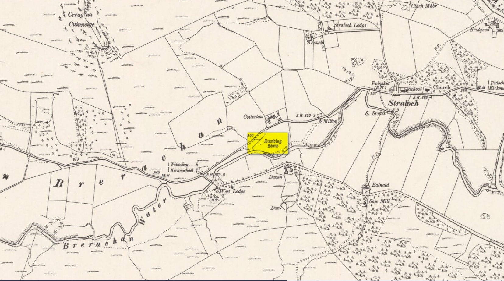
Along the A924 road, just over 4 miles (6.6km) NW from Kirkmichael, or about 8 miles (13km) NE from Pitlochry, you’ll hit the large farmhouse of Straloch. You’ve really gotta keep your eyes peeled! A few hundred yards west of Straloch itself, a small parking spot is on the south-side of the road, above the river. From this parking spot, walk a few yards to the fence that overlooks the river and look into the field below you, where you’ll see the stone. If y’ walk down the slope, you’ll see a gate on the right that leads you into the field.
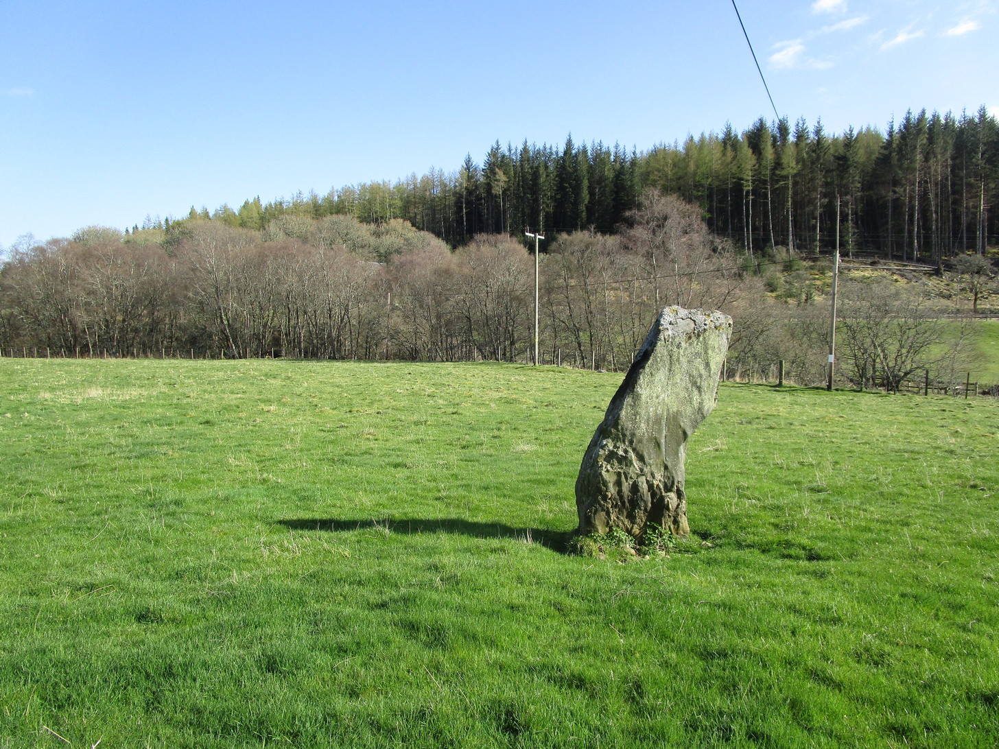
Archaeology & History
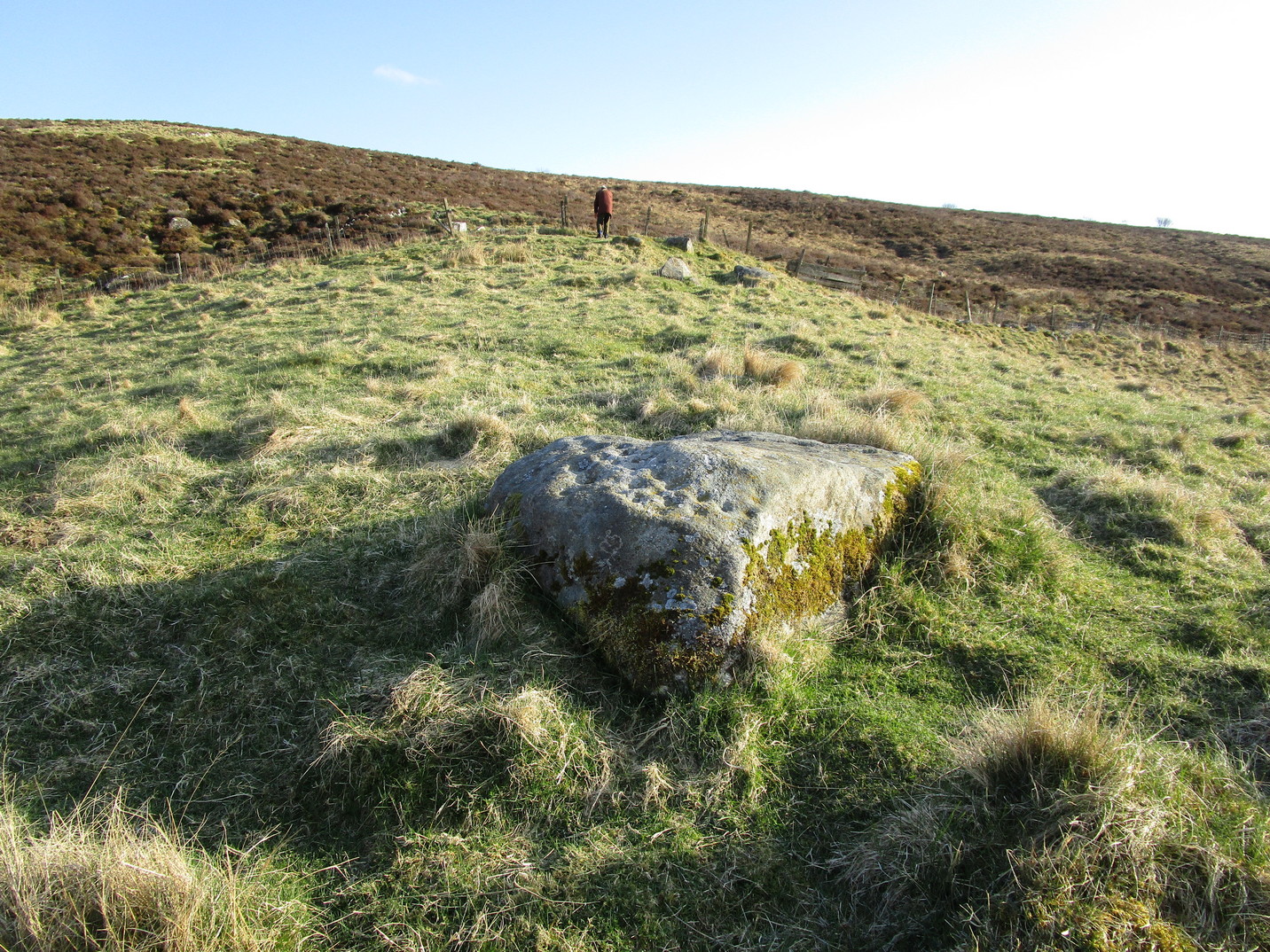
First shown on the 1900 OS-map of the area, this petrified hunchbacked witch-of-a-stone stands on the flat grassland plain (previously scattered woodland when first raised) forty yards from the River Brerachan: a proximity characteristic found at many of the stones along Strathardle.
Cotterton stone 1900 mapFred Coles’ sketch
Descriptions of the site prior to 1900 seem non-existent (does anyone know otherwise?). It was the brilliant antiquarian Fred Coles (1908) who, it seems, was the first to mention the old stone — whose very crooked appearance had an unusual effect on him, saying how “such a decided leaning over towards the north…almost make one uneasy when standing beside it”! It didn’t have that effect on me, but I was mightily impressed by both its appearance and curious hunched gait. Twas one of those monoliths that had a distinct ‘feel’ about it, which many people report at such places up and down the country. Whether it was its position by the river, or the color of the landscape, or the silence, or the shape of the stone, or combinations of them all—which ever it was, there was almost a sense of genius loci residing here…
But in that other world of pragmatic measurements, as Mr Coles told us:
“The Stone is at the base an oblong in shape, measuring 14 inches on its east end, 2 feet 7 inches along its south side, 17 inches at the west, and 3 feet 6 inches on its north side—a girth, therefore, of 8 feet 8 inches. At the middle its dimensions are the same, but the top is rather less. At its N.E. apex the Stone is 7 feet 8 inches clear of the ground, and at the west edge 7 feet. In the illustration…I have shown the monolith from the south, with the craggy profile of Menachban in the background.”
The stone was mentioned in passing in Hugh Mitchell’s (1923) local survey. A few years later in John Dixon’s (1925) account he repeated the dimensions of the stone that Coles had cited; and although he found there to be no known traditions of the place, he conjectured how it may have been connected with the numerous battles “that in former days occurred along this entrance to the Highlands.”
It’s a damn good site is this. All you megalith hunters will love it!
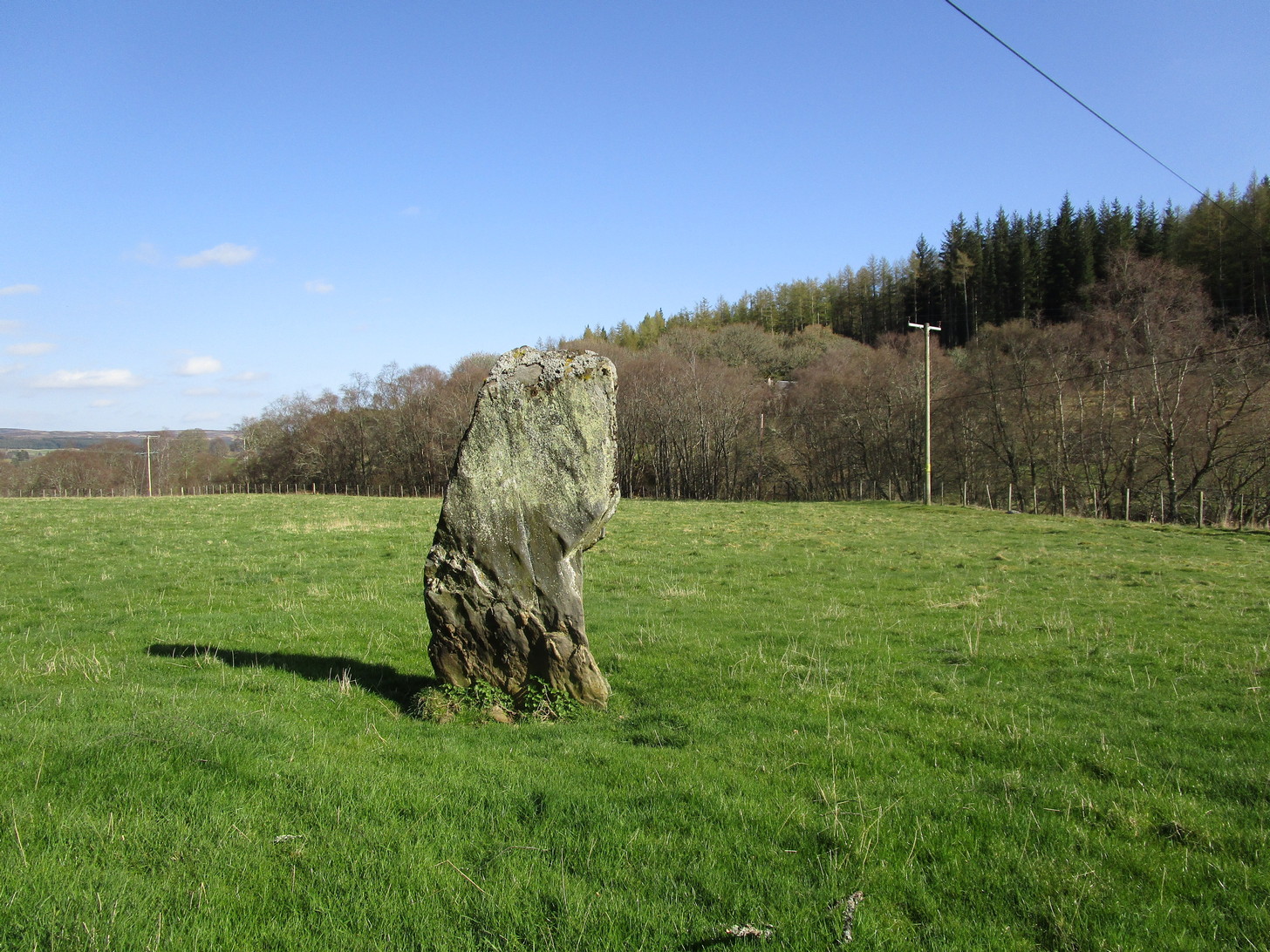
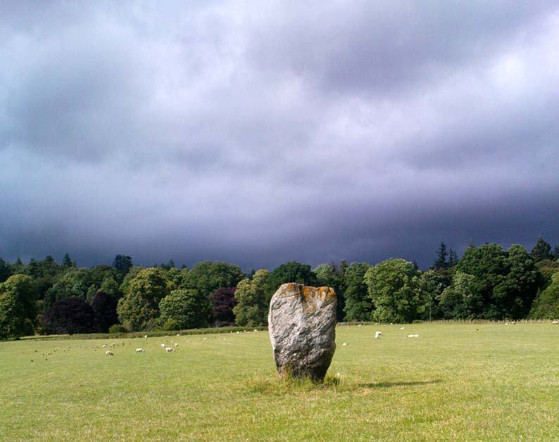
Going thru Pitlochry town, turn up the A924 road for about a mile till you hit the Moulin Inn on your left-hand side. Just past here, take the road left and continue for 2-300 yards until the stone in the field stands out on your right-hands side. Y’ can’t really miss it!
Archaeology & History
I should mebbe have this site entered as a ‘stone circle’ and not just an old monolith, as numerous other standing stones were in close attendant not too long ago and it was said to have been a circle. Certainly when the great Fred Coles (1908) talked about this place, he
“was informed by the tenant, Mr Reid…that many years ago, in his grandfather’s time, “there were several more stones standing”, all smaller than this monolith and that, upon the orders given by Mrs Grant Ferguson of Baledmund, some of these were saved from total demolition, and are supposed to be lying half-buried in the field to this day.”
…and here’s the big man close-up
Though I imagine these remnants have now been removed. Aerial images, when conditions are just right, might prove fruitful here.
But the solitary stone still standing here is quite a big fella. Heavily encrusted with quartz and more than 7 feet tall, it’s a nice fat chunky thing, with its lower half being somewhat slimmer than the top. Well worth having a look at!
Folklore
Once an old moot site, folklore also tells that an old market was once held here (there was some other folklore I had of this place, but can’t for the life of me find it at the moment!).
As you go through Pitlochry’s main street, watch out for the right-turn up the A924 road. Go up here for perhaps a mile. You’ll know you’re getting close as you pass the Moulin pub and the seeming avenue of trees opens on either side of the road. A coupla hundred yards up into the trees, there’s the left-turn up the Balnakeilly driveway. Stop! It’s on your left.
Archaeology & History
The Balnakeilly Monolith
Knocking on for nine-feet tall, there’s some debate as to the archaic authenticity on this standing stone. Ian Armit and his mate (1998) certainly wondered whether this was an ancient stone or not and, gotta say, when I came up here a coupla weeks back, I got the same impression. It doesn’t have that feel about it which comes from the real olde ones; but this could be due to it having been moved in the not-too-distant past. Though when Alan Reid wrote about it in 1911 he told us that,
“it bears marks of having been…worked slightly into shape by some pointed tool whose traces are plainly seen on several of its angles.”
Not something you’d find on monoliths that are a few thousand years old! But if this stone was moved when the entrance to Balnakeilly drive was done, or the road widened, this could account for such markings. We could do with digging into any archives that may exist about Balnakeilly or the Pitlochry roads to see if there’s any record of this stone to end the debate once and for all. Tis a good site to visit though – check it out!
“One of the great level Highland moors stretches away beneath the eye, like a dark waveless lake, contrasting with the distant heights, among which Ben Lawers rears its pyramidal summit to an elevation of upwards of 4000 feet above the level of the sea. Amid this wild Highland landscape the huge standing stones, grey with the moss of ages, produce a singularly grand and imposing effect; and from the idea of lofty height which the distant mountains suggest, they convey a stronger impression of gigantic proportions than is produced even by the first sight of the giant monoliths of Salisbury Plain.”

 I think it’s likely that there would have been more prehistoric sites in the vicinity, but a notable oddity is the almost complete absence of other recorded sites anywhere nearby. Of course, if there was anything, those thoughtful Forestry Commission heads would have destroyed it. We are left, simply, with the old but reliable notes of Messrs Dixon (1923) and Mitchell (1925) who told that, in their days, other remains did exist nearby in the form of ancient cairns and hut circles—‘Pictish’ according to tradition. If we’re lucky, some damaged parts of them might still be found at the edges, a short distance to the north west…
“on the highest part of the moorland…is a group of ‘clachan iobairt’, or stones of worship, where the Druids of old performed their mysterious rites, going round the circle of standing stones from east to west with the sun, or the ‘car deasal’, the lucky side, when they wished to invoke a blessing upon their friends, and going round the circle in the opposite direction, from west to east, the ‘car tuathsel’, or unlucky side, when they wished to pronounce a curse upon their foes.”