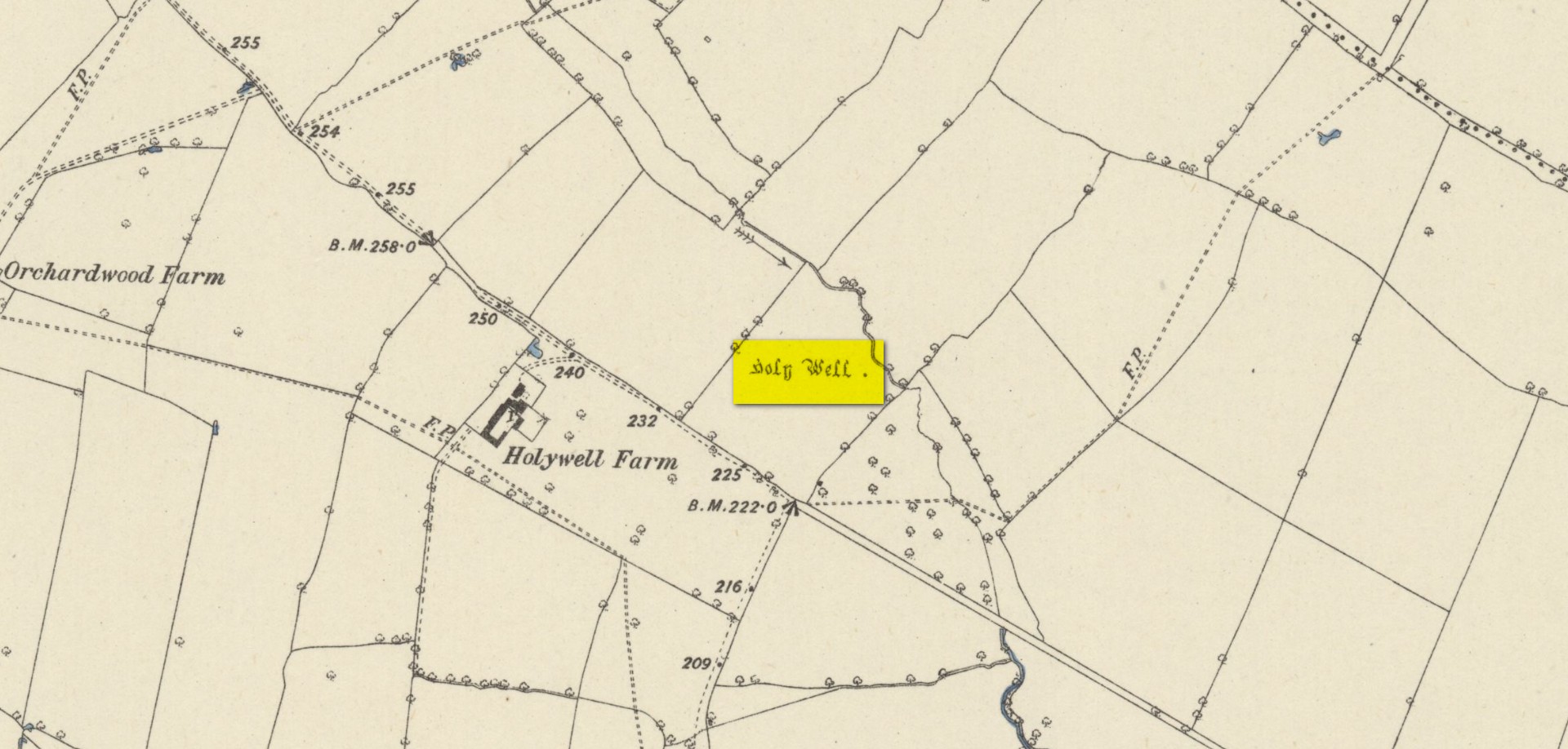
Found on the south-side of the stream a few hundred yards northeast of the aptly-named ‘Holywell Farm’ and highlighted on the early Ordnance Survey maps of the region, this once important sacred site is today, according to local folk, little more than an overgrown muddy patch, visited by very few and hard to see underfoot. It was described, albeit briefly in Leonard Jacks’ (1882) beautiful work, where he told that, “About a mile from the house is to be seen a holy well, a place of interest, which is undoubtedly connected with the past history of the place.”
In medieval times, the manor of Winkburn was the seat of the religious Order of the Knights Hospitallers, otherwise known as the Knights of St John of Jerusalem, to whom Bob Morrell (1988) professed this well to have been dedicated. He described there being a small structure around the water source, wondering whether it may have been a bath of sorts to convey water to the nearby house, but remains of this can no longer be seen. It would seem that a good ground survey of the site is required, at the end of Winter when all the vegetation has fallen back, to see if the waters can be recovered and the Holy Well brought back to life for local people. Fingers crossed! 🙂
Folklore
The water from St. John’s Well was said to be good for sore eyes. The religious celebration day of St. John is traditionally around June 24, usually overlaying earlier summer solstice celebrations.
References:
Jacks, Leonard, The Great Houses of Nottinghamshire and the County Families, W. & A.S. Bradshaw: Nottingham 1882.
Gover, J.E.B., Mawer, Allen & Stenton, F.M., The Place-Names of Nottinghamshire, Cambridge University Press 1940.
Morrell, Robert, Nottinghamshire Holy Wells and Springs, Nottingham 1988.
Acknowledgements:Huge thanks for use of the Ordnance Survey map in this site profile, reproduced with the kind permission of the National Library of Scotland.
Standing Stone (destroyed): OS Grid Reference – SK 5779 0644
Also Known as:
Little John’s Stone
Archaeology & History
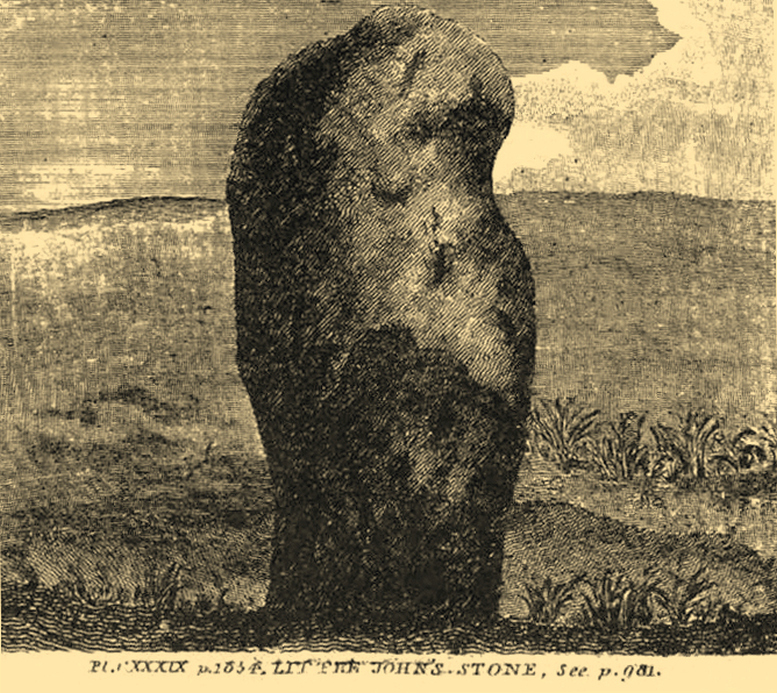
Nichols 1804 drawing
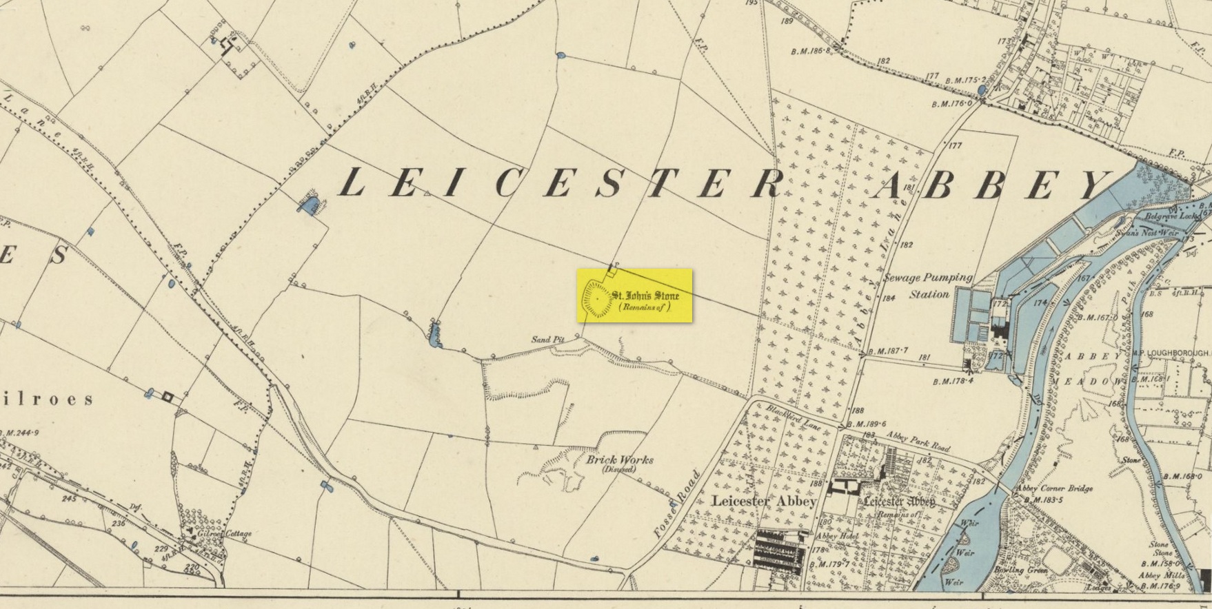
This once impressive megalithic site was first mentioned in 1381, giving its name to the field Johnstone Close. Shown on the early Ordnance Survey maps standing on a raised portion of land in an area north of the modern town centre, not far from the Abbey, its destruction had been a slow one until it finally disappeared about a hundred years ago. One of the early descriptions of it was by John Nichols (1804) in his immense series of works on the county. He called it ‘Little John’s Stone’* and gave us the first known illustration of the monolith (right), telling it to be “7 feet 2 inches high, and 11 feet 3 inches wide”—although he obviously meant circumference and not ‘wide’, as his illustration clearly shows. Although this slight error was perhaps the reason that Historic England proclaimed the stone to have been little more than “a natural feature”—which it clearly wasn’t.
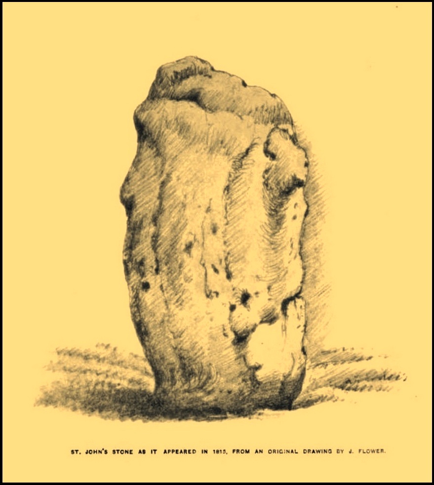
Stone shown on 1885 mapJohn Flower’s 1815 sketch
The stone stood in what Nichols called “a kind of amphitheatre”, and what James Hollings (1855) subsequently called a sloping hollow which, he thought, had “been excavated by the hand of man.” It was located “in a meadow, a little to the west of the Fosse-way,” he said, “not far from the ancient boundary wall of the Abbey of St. Mary de Pratis.” There’s little doubt it was a prehistoric standing stone. Hollings described it as standing erect and told it to be one of those “monolithic erections, or hoar stones, anciently sanctified by the rites of Druidic worship,” comparing it to “similar rude columns” in Cornwall, Scotland and just about everywhere! He also told that it was a place of summer solstice gatherings, being
“in the memory of many living, annually visited about the time of Midsummer by numerous parties from the town in pursuance of a custom of unknown antiquity.”
When James Kelly (1884) wrote about the stone, little was left of it save at ground level. He repeated much of what Hollings had previously written, but had a few notes of his own. One related to the local mayor and MP for Leicester, Mr Richard Harris, dated January 1853, who told him:
“When a boy, he had frequently played on the spot where it was customary for the children to resort to dance round the stone (which he thought was about eight feet high), to climb upon it and to roll down the hill by which the stone is in part, encircled. The children were careful to leave before dark, as it was believed that at midnight the fairies assembled and danced round the stone.”
More than fifty years later when Mrs Johnson (1906) wrote about the place she said that only a small section of the stone still remained, just “a few inches above the earth.” It had been incrementally “broken to pieces down to the surface of the ground and used to mend the road.” (Kelly 1884) Alice Dryden (1911) lamented its gradual demise in size, summarizing:
“At the beginning of the nineteenth century it was about 7 feet high, but by the year 1835 it had become reduced to about 3 feet. In 1874, according to the British Association’s Report, it was about 2 feet high, and it has now completely disappeared.”
Local tradition tells that some small pieces of St John’s Stone were moved to the nearby St. Luke’s church, where bits of it can still be seen. Has anyone found them?
More recent lore has attributed St John’s Stone to have been aligned with the Humber Stone (SK 62416 07095) nearly 3 miles to the east, in a summer solstice line—but it’s nowhere near it! A similar astronomical attempt said that the two stones lined up with the Beltane sunrise: this is a little closer, but it still doesn’t work. The equinox sunrise is closer still, but whether these two stones were even intervisible is questionable.
* this was probably the name it was known by local people who frequented the nearby Robin Hood public house (long gone); its saintly dedication being less important in the minds of Leicester’s indigenous folk.
References:
Cox, Barrie, The Place-Names of Leicestershire – volume 1, EPNS: Nottingham 1998.
Devereux, Paul, “The Forgotten Heart of Albion,” in The Ley Hunter, no.66, 1975.
Dryden, Alice, Memorials of Old Leicestershire, George Allen & Sons: London 1911.
Hollings, James Francis, Roman Leicester, LLPS: Leicester 1855.
Kelly, William, Royal Progresses and Visits to Leicester, Samuel Clarke: Leicester 1884.
Nichols, John, The History and Antiquities of Leicestershire – volume 3: part 2, J. Nichols: London 1804.
Trubshaw, Bob, Standing Stones and Markstones of Leicestershire, Heart of Albion Press 1991.
Acknowledgements:Huge thanks for use of the Ordnance Survey map in this site profile, reproduced with the kind permission of the National Library of Scotland.
Holy Well (destroyed): OS Grid Reference – SP 9848 0822
Also Known as:
St. James’ Well
Archaeology & History
Site shown on 1897 map
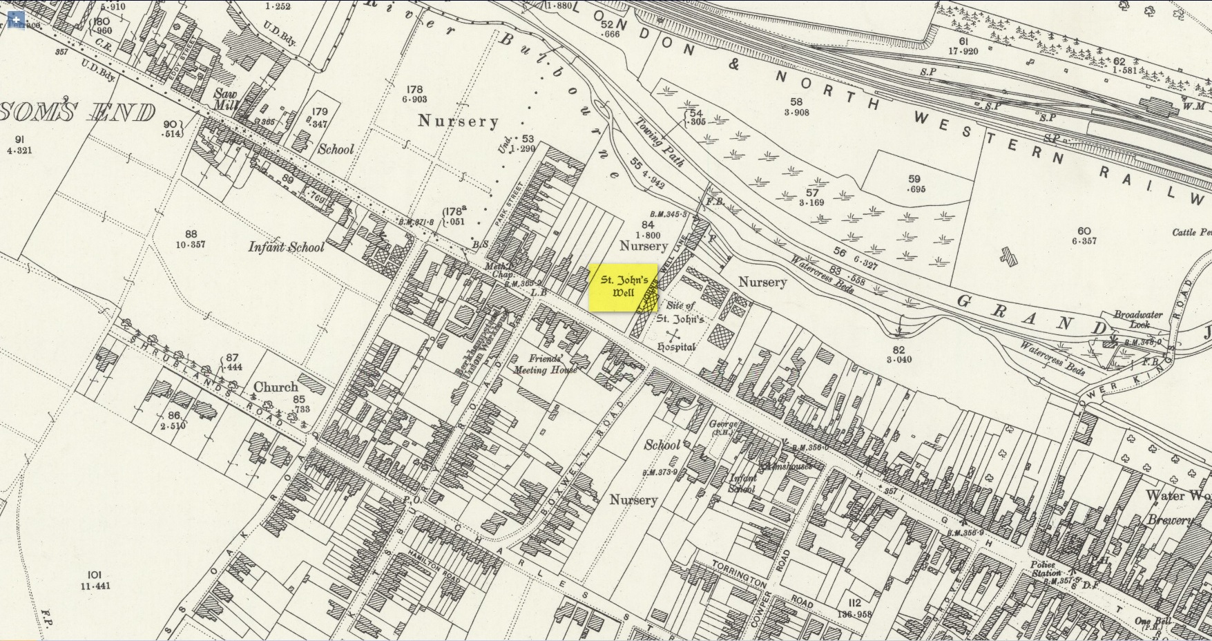
Shown on the early Ordnance Survey maps of the town, Berkhamsted’s holy well was a place of some renown in bygone centuries. Today it is barely remembered. It was initially dedicated to St. James, as it was associated with a chapel dedicated to that saint close by, but it had a change of name when the legendary Brotherhood of St. John the Baptist became the new caretakers, so to speak. As a result of this, its history can be a little confusing to some folk!
In the late 12th century, pagan worship at this site came to the attention of Hugh of Grenoble, the Bishop of Lincoln, who visited the place to stop local folk performing their animistic practices (although the exact nature of such rites were not described, sadly). It didn’t work, obviously; as once the bonkers bishop had gone, local folk would have continued in their old ways, no doubt wondering who the hell the odd incomer had been who was telling them to stop doing what they had always done here at the cost of no one. And so the waters continued to be used under the mythic cover of old St James—for the time being at least.
The well later became a centre of pilgrimage and and a hospital was been built close by dedicated to St James, where leprosy was treated and the curative waters from this well were used. St James’ Day was July 25 and an annual fair was held in Berkhamsted thanks to a Royal Charter of James I in 1619. Hertfordshire traditions relating to St James Day are described in Miss Jones-Baker’s (1974) fine survey on the customs of the county. But change was a-coming when a local monk had a dream that the waters of this “pagan spring” needed to be blessed and dedicated to the virtues of St. John the Evangelist and a shrine built where pilgrims could worship and be healed. And as Jones-Baker (1977) told us,
“The water of St John’s Well were thought to cure a variety of diseases; among these leprosy and scrofula (the King’s Evil) as well as sore eyes. There was also a persistent belief that clothing washed in its waters would impart good health to the wearers.”
In the period when the Protestant Reformation occurred, the well and its immediate surrounds apparently became derelict and overgrown. The Old Ways returned and local folk began to visit the waters again at night and the animistic rituals that would have been taken to other secret places returned to St. John’s Well. In this period a local physician, a Dr. Woodhouse, used the sacred waters as part of magickal rites to exorcise evil spirits!
In spite of the local authorities declaring in 1865 that the water was “unfit for drinking”, local folk later told otherwise. Its waters were still being used in the 20th century and its traditions no doubt retained. As the local writer Dora Fry (1954) told us:
“The families dwelling in the cottages at the Bulbourne end of the lane, just below St John’s Spring, were all remarkably healthy… Some time after the town got its first waterworks (and) the local authorities declared that the well’s water was to be used only for the gardens… but I remember as a child drinking the water from the main spring and its coolness and freshness were delectable on a hot summer afternoon.”
The well was still visible up until the 1930s, when its waters ran down a shallow channel along St John Well’s Lane, but then a shop was built above the site and the well has been lost forever.
References:
Bord, Janet & Colin, Sacred Waters, Granada: London 1985.
Acknowledgements:Huge thanks for use of the Ordnance Survey map in this site profile, reproduced with the kind permission of the National Library of Scotland.
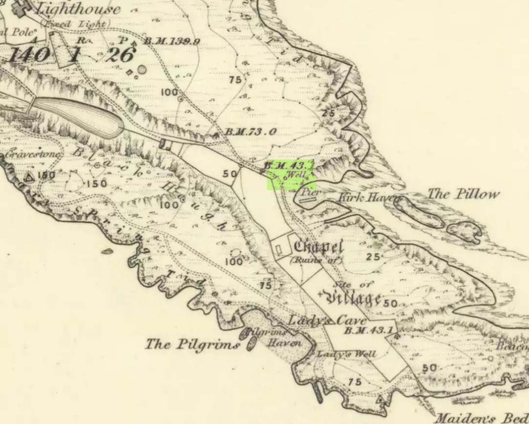
This seems to be the only ‘St John’ dedication on the Isle of May: a small island littered with more saint’s names, seemingly, than Iona and Lindisfarne combined! Illustrated on the 1855 OS-map, without name—and on the present-day large-scale OS-maps too, 20 yards or so from its 1855 position—the standard archaeo-historical records say nothing of the place. Thankfully antiquarian and folklore accounts have preserved evidence of its title. When the Victorian traveller Thomas Muir (1868; 1883) visited the Isle of May, he told how the islanders struggled to maintain a good water supply during a drought there in the 1860s. St. John’s Well was, he told,
“A pump standing by the path above Kirk Haven. The water good, but a little brackish. During all the drought of this summer we pumped water out of this well to supply our cattle.”
After Æ. J.G. Mackay’s (1896) visit to the island he told that here, along with the other holy wells on May,
“their brackish waters have lost the magic virtue they were credited with in early christian, possibly in pagan times.”
In more recent times it was described in W.J. Eggeling’s (1985) natural history survey. St. John’s Well was,
“the well within the high, cylindrical, whitewashed wall-surround lying across Haven Road from the Coal House. Also known as the Pump Well. It is a guiding mark for boats entering Kirk Haven.”
Folklore
St. John’s Day (June 24) was the christian name given to the traditional Midsummer Day, or days, around which good heathen festivals occurred; but we can find no ritual accounts of activity specific to this Well. Help!
References:
Dickson, John, Emeralds Chased in Gold; or, The Isles of the Forth, Oliphant: Edinburgh 1899.
Muir, Thomas S., The Isle of May – A Sketch, Edinburgh 1868.
Muir, Thomas S., Ecclesiological Notes on some of the Islands of Scotland, David Douglas: Edinburgh 1883.
Simpkins, John Ewart, Examples of Printed Folk-lore Concerning Fife, with some Notes on Clackmannan and Kinross-shires, Sidgwick & Jackson: London 1914.