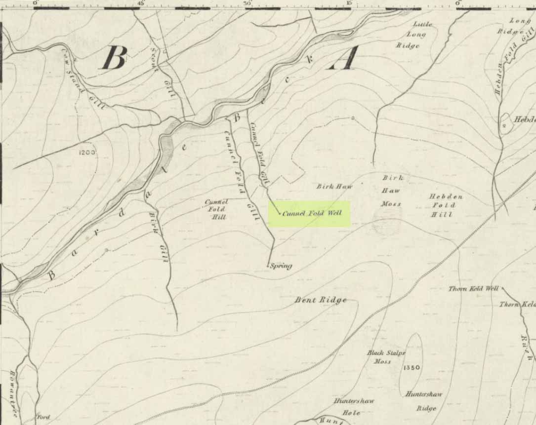
Found high on the moors several miles south of Hawes, this is a small almost insignificant water source that I sat with, drinking in both the landscape and the waters many moons ago in a daydreaming amble. It’s history is only remembered in the name it was given, no doubt by some local to the Ordnance Survey lads in their own, albeit more focussed assessment on these hills. Its name puzzled me for a long while and I wondered if some untold story lay behind it. Sadly that doesn’t appear to be the case. Although there are doubtless many tales that could be told of the people who, through the centuries, have sat and drank the waters here, we know none.
Its name very probably derives from the misapprehended dialect word ‘cannel’ which, as Mr Wright (1898) explains, is simply “a ditch…gutter, watercourse,” which seems appropriate here. Of the place-names shown on the 1856 OS-map, it seems the most likely solution to the word.
As for a place to sit and have a drink, it’s very refreshing after the rains have fallen. All too often nowadays, as with many of the old hilltop watercourses, their life-blood is falling back to Earth…
References:
Wright, Thomas (ed.), English Dialect Dictionary – volume 1, Henry Frowde: London 1898.
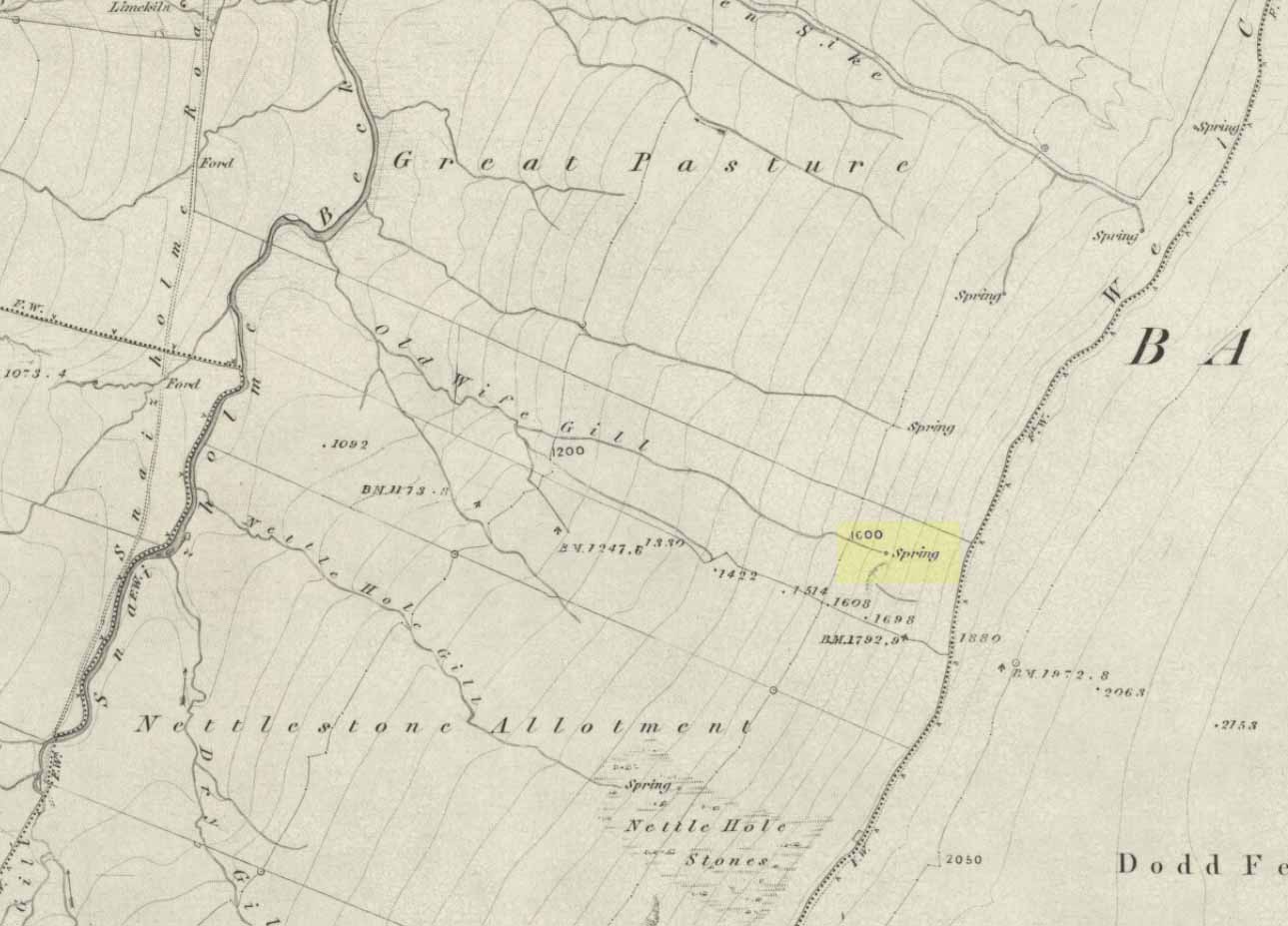
The ‘Spring’ atop of Old Wifes Gill, on 1853 OS-map
From Hawes, take the B6255 road west-ish to Ribblehead, but only for 1km, where there’s the Cam Road track on your left. Walk on here, and keep going till you’re looking down the valley past the very last house (those of you who wanna take the Pennine Way from Hawes will end up in the same place). It’s one of the springs down the steep slope on your right! (check the attached link to the OS-map to work out which one you’re heading for)
Archaeology & History
Apart from a singular mention in place-name records, I have found no historical information (yet!) about this old water supply. It was one of the great sites of the cailleach in our Yorkshire hills: a truly ancient and heathen place, all but forgotten and lost in the mythic landscape of our past. And it’s a bittova dodgy spot getting right up to her down the rather steep hilly slope — but it’s truly well worth the trek!
The Old Wife’s Spring
When I first visited this place, we took off from Cam Fell’s western side and ambled up the tops until the land gave us the beauty of Snaizeholme valley, which had us stopping, dreaming and wanting more as we sought to find this forgotten well. Most of you would probably come from the easier side of Hawes and walk along the path on the southern-side of the valley, or p’raps even wander up Snaizeholme valley itself – but I’d recommend a walk along the tops. Tis much much better!
If you’ve got the 1:25,000-scale OS-map, you’ll see the ‘Old Wife’s Gill’ running down the hillside. Get over the wall by the track-side and stagger down the steep slope. You’ll pass a small spring about 70 yards down – but this aint the one (though I think originally the Old Wife came from much further up Dodd Fell itself). You’ve got another 75 yards to go down before you get to the main spring – but if you’re old and fragile, unfit or fat, you’ll struggle like hell here!
The waters emerge from this very steep slope, surrounded by plenty of thorns and thistles, on a part of the hill where the land itself is slowly coming away. After a long dry-spell no doubt, this might be a little more secure; but when we came here She’d been raining on-and-off like hell and the waters were a-plenty. It’s difficult to actually locate the exact spot where the water first appears – but like I said, it seems to have, long ago, come from much further up the hill. As the photos show, the water’s nice n’ clear, good-tasting, and then continues along its downward stream – known as the Old Wife’s Gill – until hitting the small river at the valley bottom.
The Old Wife’s Spring from below
The other site in this valley which assures us of the cailleach’s validity comes from the place-name a few hundred yards further up the valley, seemingly giving source to the valley river herself: a Lady Spring or well, whose form once emerged close to the gate of the Cold Well close by. The third part of the cailleach’s form – the maiden or virginal – has been lost as far as local myth and literary records go. But I’ve gotta come here a few more times to get an idea as to where this ‘lost’ water-source originally appeared. A number of streams run off the hills here into the curiously-named Snaizeholme valley (which etymologists assign to nowt more than a “place where twigs are” – which seems nonsensical), and as there’s been very little by way of human habitation screwing the land up, there’s a damn good chance we’ll find and recover the mythic history of the landscape here after a few more treks and dreams…
Other sites of similar mythic relevance which need checking include Carlow Hill (SD 770 858)at Stonehouse, Dentdale; and the great valley of Carlin Gill on the North Yorkshire/Cumbria border (SD 634 993 – Gambles 1995:39).