Perusal of a 25″ OS map of 1867 shows, in almost microscopic lettering, a feature marked ‘Bogle Bush’. I transferred the approximate location onto a modern map and set off to make a field visit, honestly not expecting to find anything almost a century and a half later.
The Bogle Bush
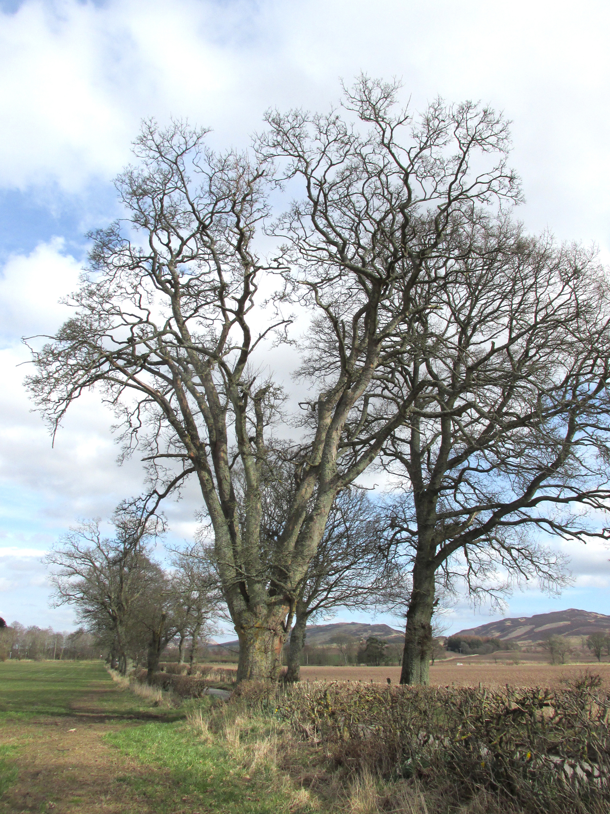
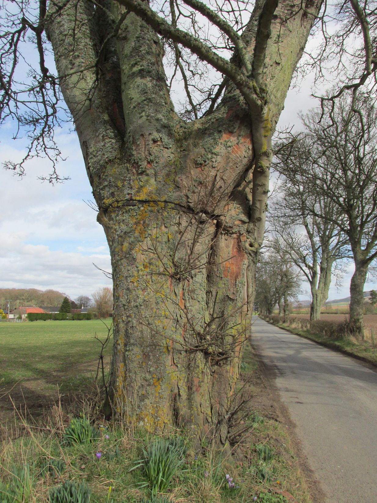
As I walked down the designated road I was drawn to an ancient multi branched or trunked tree, the trunks held together by a hefty iron band. The band had been placed there many years ago as it was being absorbed by the growth of the tree. Unlike the other trees in the road the foot of this tree had crocus and grape hyacinth in flower, as if deliberately planted.
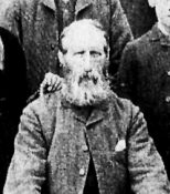
The band was forged and fitted by Kinrossie Blacksmith and Kirk Elder David Gray at the end of the nineteenth century, following the collapse of one of the three trunks then standing.
The band holding the tree together
The online Ordnance Survey Name Books for Perthshire, compiled prior to the survey of the 1867 map, list Robert Millar of Flowerdale, Mr James Stewart of Kinrossie and Mr Fraser of St Euchans as the informants that ‘This name is applied to a Birch Tree situated on the north side of the road leading from Saucher to Kinrossie. Mr Millar says that there is a superstitious tradition existing in the locality that Bogles have been seen &c at this tree’.
Whether Mr Millar and his co-informants were trying to mischievously mislead the (probably) English Ordnance Survey officials, we will never know, but the tree is in fact a Sycamore! And the 1901 25″ OS map shows the tree as the ‘Bogle Busk’.
Folklore
There has been speculation that the Bogle Bush may have long forgotten links with Macbeth whose fortess at nearby Dunsinnan Hill overlooks it, adding the rider that Sycamores only live 200 years or so before falling and then regenerating on the same spot, implying that a mother tree could have been on the same spot in Macbeth’s time.
David Gray, Blacksmith and Kirk Elder of Kinrossie.
Local folklore states that ‘a great calamity will befall Kinrossie’ should the Bush collapse. The tree is a local icon that’s ‘aye been there’ according to a local resident and it seems to be a local geo-caching site, judging by the small container of ‘stuff’ hidden in a plastic container underneath a couple of pieces of bark at the base of the trunk on my visits.
Please note that if you decide to visit, this is not a wishing tree, so do not hammer coins into the bark or suspend rags from the branches. Respect the Bush and the local people to whom this is an iconic tree.
My thanks to local resident Morag Hislop for leading me to further information on this site.
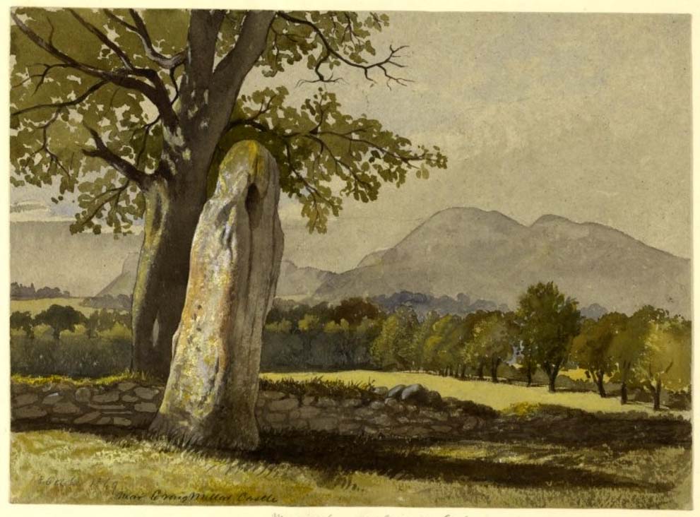
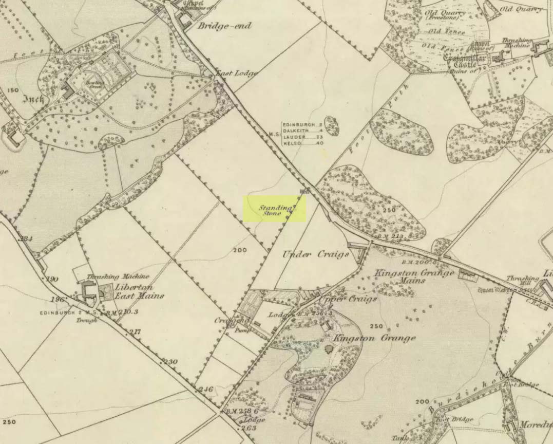
Take the A7 road south from Edinburgh central (off Princes Street) for several miles. It becomes known as the Old Dalkeith Road eventually, just as it passes the huge wooded ground of Craigmillar Castle on your left (east) and the Inch estate on your right. Walk along here, keeping your eyes peeled for the small path that takes you onto Ravenswood Avenue. Barely 30-40 yards from the main A7 road, the standing stone is there surrounded by railings.
Archaeology & History
A curious place to find a standing stone – especially one that’s still alive! But that’s what we find on the Inch housing estate, thankfully. Highlighted on the 1855 Ordnance Survey map, it was one of a number of standing stones described in George Good’s (1893) fine survey on Liberton parish, which he thought commemorated ancient battles. When he wrote about it, the monolith was “built into the wall on the public road to Greenend”, just as shown on the OS-map. He told how the
“stone was taken down in the beginning of the present century (c.1801), when the road was widened, and it long lay in the field opposite, but was restored to its original place in 1891.”
When the Royal Commission (1929) lads came here many years later, they gave their own archaeocentric description, telling:
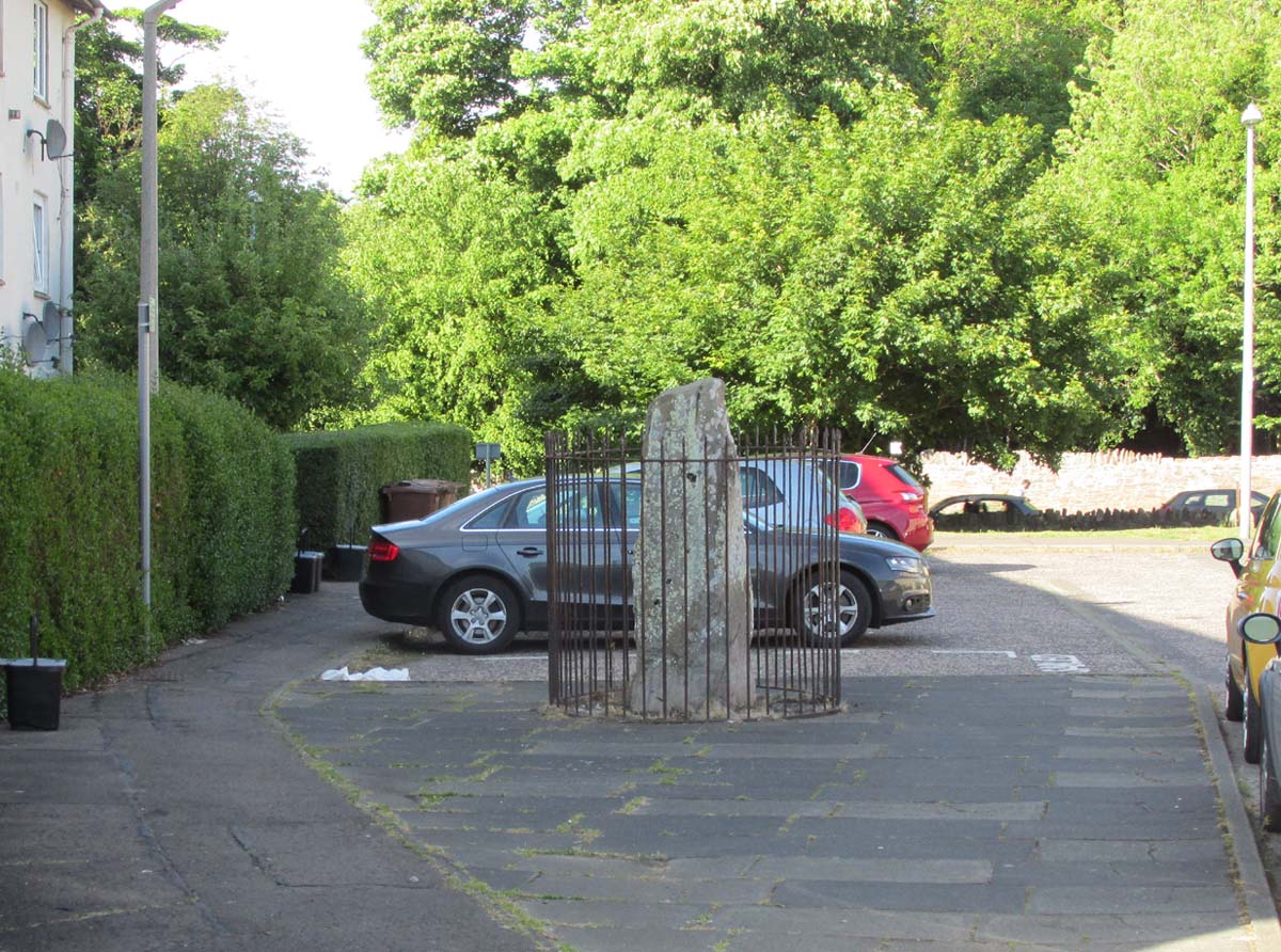
Site shown on 1855 mapThe old stone in its cage
“About 40 yards from the main road near Little France…is a standing stone, which is set up without packing, with its main axis almost due north and south, but with a slight inclination towards the east. It stands 6¾ feet above ground, and has a girth of 6 feet 5 inches at 3 feet from the base. It is of grey sandstone, badly weathered on two sides and without traces of any artificial markings or design.”
The monolith was included in Adam McLean’s (1977) megalithic survey of the area, where he rightly said how the iron fence that surrounds the stone destroys any atmosphere that might once be had here. Still, at least it’s still standing and is worth checking out if you’re in the area.
Folklore
The Ravenswood Stone
An old footpath that runs dead straight from Craigmillar Castle towards the stone was long ago said to be the pathway taken by the ghost of a white lady.
In days prior to the housing estate being built, local folk had annual bonfires here between Samhain (Halloween) and Guy Fawkes Night (Oct 31 – Nov 5).
References:
Good, George, Liberton in Ancient and Modern Times, Andrew Elliot: Edinburgh 1893.
McLean, Adam, The Standing Stones of the Lothians, Megalithic Research Publications: Edinburgh 1977.
Royal Commission on the Ancient & Historical Monuments of Scotland, Inventory of Monuments and Constructions in the Counties of Midlothianand West Lothian, HMSO: Edinburgh 1929.
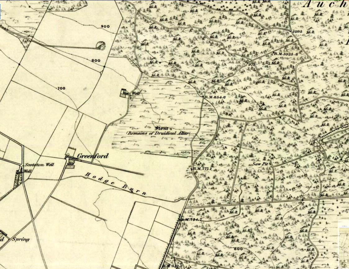
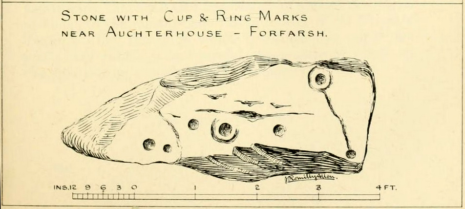
We have no precise location for this carving, nor several of its petroglyphic relatives who lived within this arena for countless centuries until (you guessed it!) the advance of the Industrialists brought their profane ways to the region, with the usual disregard for local people and their unwritten traditions. Which is a great pity, for there were obviously some old stories and important archaeology hereby. Aubrey Burl (1988) for one, thought this cup-and-ring carving may have played its part in being one of the stones in a larger “four-poster” stone circle, although local history accounts tell that it was part of an impressive prehistoric tomb.
One of the Witches Stones
The Witches’ Stone we see illustrated here was one of at least two carvings in a cluster of stones. The great J. Romilly Allen (1881) wrote about the it, although it seems he never visited the site himself. Instead, his description came from that of a colleague, a Mr W. McNicoll, who told him that at the position marked on the early OS-map as a single “Stone” that was “Remains of a Druidical Altar” there were in fact
“two in number: one, an upright pointed stone, 5ft by 2ft by 3ft 6in high; ans the other lying 3ft 6in to the southwest, 7ft 6in by 5ft by 2ft 6in thick. The latter has fifteen cups, varying from 2 to 3in in diameter; one with a single ring carved on the sloping face at the south end of the stone. It lies horizontally and has two hollows, worn at the ends where the cups are, by the toes of persons climbing onto the top. The ground under this stone has been partly removed and it appears to rest on two others; but the whole appears to be natural and not a cromlech or rocking stone.”
Folklore
One of the Witches Stones
Reference was made to this “Witches Stone” in the 1860 Object Name Book of the region, where it was said to have been part of a larger group, “considered to have been used by the Druids as a place of worship.” This catch-all phrase of druidic relevance should be translated as “local traditional importance” where animistic rites of some sort would have occurred. Certainly we find the usual reverence or fear in the local tale told by Mr Hutcheson (1905) which he thankfully recorded following his visit to the site:
“Here…occupying a small knoll known locally as Greenfield Knowe, towards the western end of the plateau…two upright standing stones of boulder character formed a conspicuous feature. They were, if tradition be accepted, the survivors of a larger group. The same tradition records that the farmer of Greenfield Farm, requiring stones for the erection of dykes, removed some of the standing stones from Greenfield Knowe. He, however, speedily found unexpected difficulty in carrying out his intentions. The dykers whom he had employed absolutely refused to use the stones, alleging they would thereby bring misfortune upon themselves and families, , and threatened, rather than risk such calamities, to throw up the job.
“While in this quandry the farmer, it is said, had a vision: a ghostly figure appeared to him, and in a hollow voice warned him against interference with he stones on Greenfield Knowe, and concluded by the adjuration, “Gang ower the howe t’ anither knowe.” Needless to say, the farmer lost no time in obeying his ghostly visitor. Next morning he carted back the stones he had removed and sought material for his dykes elsewhere.”
This is probably the same tale, slightly reformed, which the local historian W.M. Inglis (1888) described, when he told that,
“About the beginning of the present century, when a worthy old parishioner was having some repairs carried out upon his house, he removed a few of the large stones with the intention of having them built into the walls. Throughout the night, however, an eerie feeling came over him, his conscience was on fire, he could get no rest. Accordingly he got out of bed, yoked his horse into the cart, and like a sensible man replaced yjr sacred stones where he found them, went home, and thereafter slept the sleep of the righteous.”
Whichever route you take to reach this lovely hamlet, hiding away in deep greenery, when you get to the one and only road junction, where it goes downhill (towards the old church), look just above you just below the first tree. All but covered in vegetation, the ruined stone lays down there. Climb up and see!
Archaeology & History
Tis up on the verge here
An exploration of this site was prompted when fellow antiquarian, Paul Hornby, came across the curious place-name of ‘Ghaist Stane’ when he was looking over some old Ordnance Survey maps of the region. So we met up and took a venture over there! Last highlighted on the 1865 map (when the old village was known as Fearn, not the modern spelling), even the Canmore lads had missed this one. But it’s not easy to find….
After meandering back and forth by the village roadside, on the tops of the walls, into the field above, Paul eventually said, “Is that it?!” just above the roadside, almost buried in vegetation below the roots of a tree. So I clambered back up and brushed some of the vegetation away – and there it was – in just the place that the old OS-map showed it to be (give or take a few yards).
The remains of the stone measure roughly 3 feet by 3 feet; with the present upper portion of the stone being of a lighter colour than the lower portion, indicating that this section of the stone was the portion that was underground when it was standing upright. Its history is fragmentary, but we know that it was almost completely destroyed in the middle of the 19th century. Notes from the Object Name Book of the region in 1861 told,
“The “Ghaist Stane”…formerly well known, is becoming little known from the stone having been recently blasted in making the Dike it now forms a part of, but it may be observed in the wall as a huge stone much larger than those beside it in the Dike. It does not project now from the side of the Road.”
Now the stone is almost entirely forgotten and lays covered, ignored, even by local people. It could do with being resurrected and its heritage preserved before it disappears forever.
Folklore
The uncovered Ghaist Stane
The word “ghaist” is a regional dialect word meaning “a ghost or goblin”, inferring that the site was haunted. And, considering the inherent animistic cultural psychology of the people here in earlier centuries, we must also consider the distinct possibility that the stone itself was the abode of a resident spirit, perhaps an ancestral one of a local chief, or queen, or elder of some sort.
In James Guthrie’s (1875) analysis of the folklore of Fern township, he told of the peculiarly odd violent brownies of the district and thought that they and the spirit of the Ghaist Stane were one and the same.
“In addition to the leading characteristics of Brownies in general the more prominent of these being, that they forded the rivers when their waters were at their highest, and that the sage femme always landed safely at the door of the sick wife—the brownies of Ferne are connected with scenes of cruelty and bloodshed. This peculiarity would seem to indicate that the brownie and the ghaist of Feme, were one and the same. The Ghaist Stane is in the vicinity of the church. To this piece of isolated rock, it is said this disturber of the peace was often chained as a fitting punishment for his misdeeds, but tradition is silent as to the brownie being similarly dealt with, which strengthens the supposition that they were, in this quarter at least, generally regarded as one being.”
The spirit of the Ghaist Stane roamed far and wide in the district it seemed, and a long rhyme telling a tale of the ghaist was once well-known in the area which, thankfully, Mr Guthrie gave us in full:
THE GHAIST O’ FERNE-DEN
There liv’d a farmer in the North,
(I canna tell you when),
But just he had a famous farm
Nae far frae Feme-den.
I doubtna, sirs, ye a’ hae heard,
Baith women folks an’ men,
About a muckle, fearfu’ ghaist —
The ghaist o’ Ferne-den!
The muckle ghaist, the fearfu’ ghaist,
The ghaist o’ Ferne-den;
He wad hae wrought as muckle wark
As four-au’-twenty men!
Gin there was ony strae to thrash,
Or ony byres to clean,
He never thocht it muckle fash
0′ workin’ late at e’en!
Although the nicht was ne’er sae dark,
He scuddit through the glen,
An’ ran an errand in a crack —
The ghaist o’ Ferne-den!
Ane nicht the mistress o’the house
Fell sick an’ like to dee,—
“O! for a oanny wily wife!”
Wi’ micht an’ main, cried she!
The nicht was dark, an’ no a spark
Wad venture through the glen,
For fear that they micht meet the ghaist —
The ghaist o’ Ferne-den!
But ghaistie stood ahint the door,
An’ hearin’ a’ the strife,
He saw though they had men a score,
They soon wad tyne the wife!
Aff to the stable then he goes,
An’ saddles the auld mare,
An’ through the splash an’ slash he ran
As fast as ony hare!
He chappit at the Mammy’s door—
Says he — “mak’ haste an’ rise;
Put on your claise an’ come wi’ me,
An’ take ye nae surprise!”
“Where am I gaun?” quo’ the wife,
“Nae far, but through the glen —
Ye’re wantit to a farmer’s wife,
No far frae Ferne-den!”
He’s taen the Mammy by the hand
An’ set her on the pad,
Got on afore her an’ set aff
As though they baith were mad!
They climb’d the braes—they lap the burns—
An’ through the glush did plash:
They never minded stock nor stane,
Nor ony kind o’ trash!
As they were near their journey’s end
An’ scudden through the glen:
“Oh!” says the Mammy to the ghaist,
“Are we come near the den!
For oh! I’m feared we meet the ghaist!”
“Tush, weesht, ye fool! “quo’ he;
“For waur than ye ha’e i’ your arms,
This nicht ye winna see!”
When they cam to the farmer’s door
He set the Mammy down:—
“I’ve left the house but ae half hour—
I am a clever loon!
But step ye in an’ mind the wife
An’ see that a’ gae richt,
An’ I will tak ye hame again
At twal’ o’ clock at nicht!”
“What maks yer feet sae braid?” quo’ she,
“What maks yer een sae sair?”
Said he, — “I’ve wander’d mony a road
Without a horse or mare!
But gin they speir, wha’ brought ye here,
‘Cause they were scarce o’ men;
Just tell them that ye rade ahint
The ghaist o’ Ferne-den!”
References:
Guthrie, James C., The Vale of Strathmore – Its Scenes and Legends, William Paterson: Edinburgh 1875.
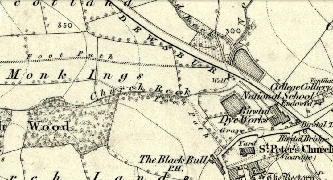
Seemingly built over in recent years, the Pickel Well was one of the main water supplies to the people of Gomersal and Birstall in earlier times. Getting its name, probably, from the northern dialect word pikel or pickel, meaning “very heavy rain” (Joseph Wright [1903] associates it with the expression “raining cats and dogs”), this may be a description of the heavy flow of water which helped feed the large man-made ponds either side of the road.
The Monk Ings Field in which it was found, derives its name from the monks from Nostell Priory who lived here, centuries ago. They would, no doubt, have drunk the water from this well.
Folklore
A very curious legend relates to this place. H.A. Cadman (1930) told,
“that whenever a birth was expected in Great Gomersal, a pad-foot came out at night from the Monk Ing fields and shouted out, ‘Thee first or me first!’ This was said to be a warning to people not to go out.”
Padfoots were phantom black dogs, stories of which occur all over northern England and beyond. They were ostensibly interpreted as omens of doom and bringers of Death. This example at Gomersal is peculiar in that it is equated with birth, as well as giving warnings for local people to stay indoors, as is more usual.
Incidences of black dogs at wells are not uncommon. In West Yorkshire alone we find them haunting the waters at Low Moor, Idle, Thorp Arch, Eccleshill, Heaton and others. Their nature is quite complex, but ostensibly derives from animistic cyclical notions of death and rebirth—hence their emergence sometimes from wells; and in this instance, presaging a local birth.
References:
Cadman, H. Ashwell, Gomersal, Past and Present, Hunters Armley: Leeds 1930.
Eliade, Mircea, Zalmoxis – The Vanishing God, University of Chicago Press 1972.
Wright, Joseph (ed.), English Dialect Dictionary – volume 4, Henry Frowde: London 1903.
References to this site seem very scarce. A well is highlighted on the 1866 OS-map of the region close to the spot which D.D. Dixon (1895) said it was found, “near to the Howbalk Lane end, where is also the Hawklemass Stile and Hawklemass Well.” A stone trough could once be seen here, but its presence today needs to be confirmed by local researchers. The site is listed in Binnall & Dodds (1943) survey, but with no additional comments to those made by Mr Dixon.
Folklore
The historian D.D. Dixon (1895) told that the village of Whittingham only had one ghost, but it was known as the “Hawklemass Ghost” and was occasionally encountered at the Hawklemass Well:
“This was a place never passed after nightfall by the youth of the village without feeling an eerie, creepy sensation, and with many a furtive glance on either side. This unearthly visitant, in its gambols and uncanny pranks, was said to rattle the chain by which it was supposed to be bound in a fearsome manner. It was usually seen or heard by persons who, having lingered long at the village inn, could say with Tam o’ Shanter,
“While we sit bousing at the nappy,
An gettin’ fou and unco happy,
We think na on the lang Scots miles,
The mosses, waters, slaps and styles,
That lie between us and our hame.”
One Saturday night many years ago—perhaps fifty—a poor fellow on his way from Whittingham to Glanton fel into the roadside at Hawklemass, where he was found, quite dead, the next morning by some persons on their way to Glanton meeting. This sad affair may have given rise to the tradition of the Hawklemass Ghost.”
The name of the old lane at whose junction the Hawklemass Well once flowed, ‘Howbalk Lane’, may derive from a lost tumulus, as the word how (and its variants) regularly relate to prehistoric mounds in our more northern climes. Such an ancient tomb, close to the well, may be the origin of the ghost story.
References:
Binnall, P.B.G. & Dodds, M.H., “Holy Wells in Northumberland and Durham – part 2”, in Proceedings of the Society of Antiquaries Newcastle-upon-Tyne, 10:2, 1943.
Dixon, David Dippie, Whittingham Vale, Northumberland, Robert Redpath: Newcastle 1895.
Acknowledgements: With thanks to Gill Rutherford for prompting me to finish this; and to Claire Heron for the OS-map reference.
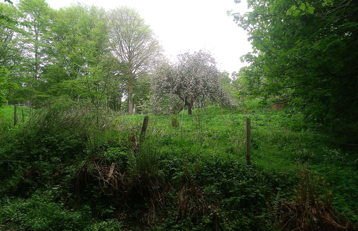
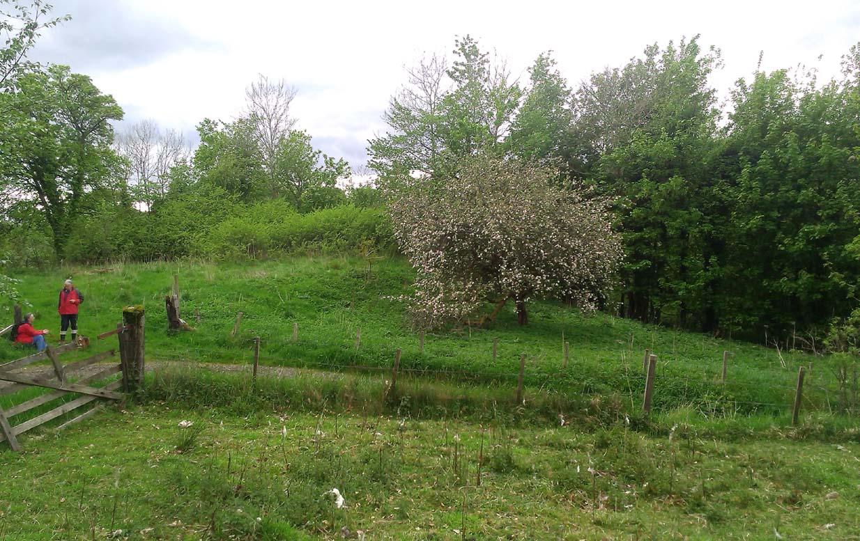
A fascinating site that was described in Johnston & Tullis (2003) local history work on the parish of Muckhart. Amidst an area bedevilled with faerie, boggarts, ghosts and historical shamanic moot sites we find more curious folklore pointing at a long forgotten site, whose age and precise nature remains a mystery. Adjacent to the old boundary line, close to the meeting of streams, the Muckhart authors told that,
“an orchard above the old farmhouse to this day remains mainly untouched. It was the burial site of warlocks from the parish and it is thought some may have even been burned at the Mill. It has always been said that this ground should never be touched! There is an ancient rubble bridge over the Hole Burn which has a Masonic Eye painted on it to ward off any unwelcome spirits. Despite the eye, both the Farmhouse and the Millhouse have been home to many strange and ghostly manifestations.”
The folklore sounds to be a mix of archaic and medieval animistic traits: perhaps of a prehistoric cairn, visited and maintained by local people (as found throughout Britain) until the Burning Times, when christian fanatics arrived, debasing the cultural rites and murdering local innocent people. …Perhaps not.
Looking down on the orchard
When Paul, Maggie and I explored the area a few days ago, we were greeted most cordially by the owner of Muckhart Mill, who knew of the folklore, but didn’t know the exact whereabout of the grave. We couldn’t find any clues as to its exact location either. Apart, perhaps, from the top of the hill immediately above the orchard where, alone and fenced off with an old covered (unnamed) well, a solitary Hawthorn tree stood. We each recalled the aged relationship that Hawthorn has in witch-lore… but that’s as far as it went. The grave remains hidden and may have been destroyed. If anyone discovers its whereabouts, please let us know so that a preservation order can be made to ensure its survival.
References:
Johnston, Tom & Tullis, Ramsay (eds.), Muckhart, Clackmannanshire: An Illustrated History of the Parish, MGAS 2003.
Of all the ancient wells in the city of Glasgow, this has to be one of the most intriguing! Descriptions of it are few and far between, but it is the name of the site which is of interest, to folklorists and occult historians alike. For the word ‘Bogle’ is another term for a ‘boggart’ or goblin of some sort! The well is mentioned in Andy MacGeorge’s (1880) excellent study in his description of ancient wells in the city. Citing notes from the 17th century, amidst many sites,
“Another was Bogle’s Well, in regard to which there is a minute of the town council “that Bogillis Well should be assayed for bringing and convoying the water of the same to the Hie street according to the right the town hes thereof,” and the magistrates are recommended to arrange for having this done “by conduits of led.””
…Obviously in the days when they were clueless about lead-poisoning! The word ‘bogillis’ is the early plural form of the bogle, or bogill (Grant 1941:201). But where exactly was this old well? Are there any other records hiding away to help us locate its original position? It seems to have been one in a cluster of legendary and holy wells in a very small area scattered between Glasgow’s cathedral, down the High Street and to the northern banks of the River Clyde… (the grid-reference given for this site is an approximation)
In a less esoteric fashion, the occult historian Jan Silver suggested that the name of the Well may relate to the family name, ‘Bogle’. This could indeed be the real story behind the well’s name.
Folklore
Traditionally ascribed in the lower counties of England to be an evil malicious sprite, in more northern counties and in Scotland the creature was said by Katherine Briggs (1979) to be a more “virtuous creature”, akin to the helpful brownies or urisks of country lore. This was said to be the case in William Henderson’s (1868) Folklore of the Northern Counties. Whether this well was haunted or the home of a bogle, we do not know as the folklore of this site appears to be lost; so I appeal to any students who might be able to enlighten us further on the place. The Forteans amongst you might have a cluster of ‘hauntings’ hereby, perhaps….
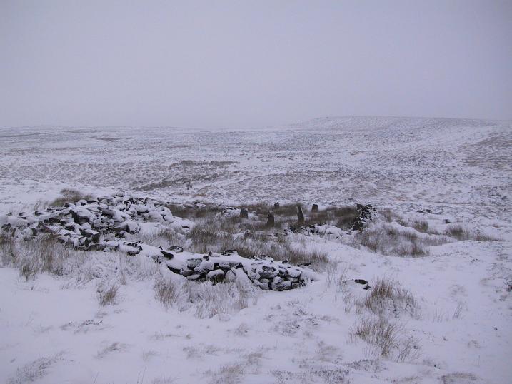
The ruins of Backstone Circle (photo, Richard Stroud)
There are many routes to get here, but this is the one I usually take. From Cow & Calf Rocks, walk up the steep hillside onto the first moorland plain, taking the path right, diagonally, across to the NW as if you’re heading to the Map Stone. From here, looking down at the stream valley below, follow the valley edge up, past the settlement, and then veer down to Backstone Beck and up on the other side till you meet with a footpath and also up in the heather ahead of you, notice the jumbled walling less than 100 yards away. That’s where you need to be!
Archaeology & History
A singular short sentence in Robert Collyer and J.H. Turner’s Ilkley, Ancient and Modern (1885) started it all off, where they told:
“There was still a rude circle of rocks on the reach beyond White Wells fifty years ago, tumbled into such confusion that you had to look once, and again, before you saw what lay under your eyes.”
…..And thankfully this is still what we see today – and in just the area they mentioned.
I’m intrigued to find there’s so much said about this site on the Net and feel I should put my recent feelings about the place to print at last (and after being badgered to gerrit done by James Elkington!). The information about its make-up and the mess it’s in, hasn’t changed since we rediscovered the place on June 3, 1989. Here, amidst the tall grasses and reeds of Juncus effusus and J. conglomeratus, our jumble of megaliths hides within a breakdown of fallen walls, that are thought to have been part of some sheep-fold or a similar animal enclosure (mebbe for the annual sheep-shagging contests that are held, quietly, on these moors each year!).
The name ‘backstone’ itself come from the adjacent beck (slowly depleting as the years pulse by) and is mentioned in the 18th century parish registers. A.H. Smith (1961) informs us that it was the “stream where bakestones were got”, and this was probably a tradition going way way back. The baking stones from the beck may even have been used by the people living in the prehistoric settlements close to the circle.
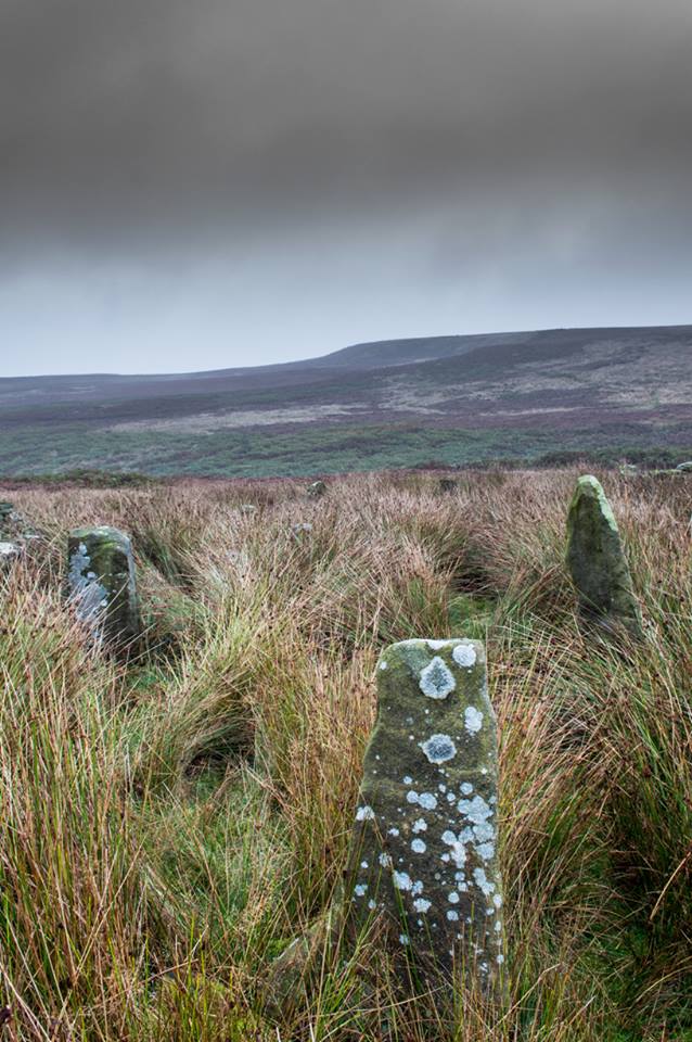
Stones amidst the reeds
In what looks today like a messy double-ring of stones, it’s likely there was originally just a single ring which has, subsequently, been knocked down and re-used for some form of sheep-fondling sessions—be it agricultural or otherwise! But for the record at least: we have small inner ‘ring’ of four upright stones, re-worked in more recent centuries, between two-and-a-half to three-and-a-half feet tall. Another stone is recumbent. The outer ring is more conspicuous. It consists of at least eight standing stones–seven of which are upright–between three and five feet tall, some of which have been re-worked in more recent times. There are several other stones either recumbent or partly covered by vegetation. The tallest of the stones is 4’11” tall. The outer circle has had at least one of the stones uprooted and used at the base of the dry-stone walling intruding the southwest side of the circle. What appears to be at least two original standing stones are embedded into earthworks on the other side of this wall, one of which was located through dowsing!
The best section of the ring can be seen on its eastern side, where an arc of upright stones between three and four feet high are still clearly in evidence, just inside a raised embankment like that found surrounding the Twelve Apostles stone circle less than a mile away.
A short while after finding the site, we contacted the Ilkley Head of Archaeology Studies, Gavin Edwards, about the circle and he subsequently included the site on one of the tourist-guides to the moors.
Alignments through this circle seem apparent in situ; and although such alignments are intriguing (to me anyhow), it’s the geometric relationship Backstone has with other circles on these moors that is rather notable. It’s position in the landscape plays an essential part in an isosceles triangle formation, 1180 yards [1.08km] from the Twelve Apostles stone circle which, as the centre point, is another 1180 yards from the Roms Law Circle. Odd….
Immediately visible from our ruinous circle across the small valley to the slopes of Green Crag, the Ilkley Archaeology Group spent more than fifteen years excavating the remains of what was initially thought of as a Bronze Age village, but their work here has proved startling, pushing the date of human occupation here into the mesolithic period! Local archaeologist Gavin Edwards opined that the Backstone circle would have been the religious site for the people who lived here. I have to concur. There are also more neolithic and Bronze Age walling, indicative of extended settlements and enclosures, less than 200 yards north of the Backstone Circle, structurally consistent with the remains across the valley at the excavated Green Crag Slack settlement.
Ten yards east of the circle is a small well which only runs following exceptional rainfall. This was probably of some ritual importance to the people who practiced rites here. Geological fault lines run not far away on three sides of the ring and an underground stream is present, quite close to the surface (as indicated by the presence of Juncus conglomeratus and J.effisus), encouraging the preponderance of regular electromagnetic variations: these in particular are likely to have some causative influence on the paranormal events described below….
Fortean History
Since rediscovering this site, a number of bizarre psychophysical anomalies have been experienced and described by more and more people — some of whom were previously very sceptical of such things. Both day and night, no doubt when Moon and water speak their subtle electromagnetic accord, a gathering corpus of all-too-familiar events keep speaking of a most disturbing resident spirit…
We begin on Wednesday, July 12, 1989, sometime around midnight, when an acquaintance and I were spending a few days here to record any possible electromagnetic anomalies at this disturbed ring of stones. We weren’t to be disappointed, as something very untoward raised its peculiar head.
As I sat barely ten yards beyond the tumbled group of stones there suddenly appeared, from nowhere, a host of figures—a dozen at most—walking ever so slowly around the old site. I could discern no physical features other than their height and humanoid shape. It was just too dark to see any details about them—they were, effectively, silhouettes. My acquaintance was terrified—although it was perhaps a minute or so before he even glanced at what I was pointing and exclaiming at, somewhat manically, stuttering and shaking my head in an attempt to make the things disappear back to my unconscious where they surely originated. Didn’t work though!
These were no psychic projections. I literally shook my head, closed my eyes and knocked my head against the walling; looked away, shook my head again, shouting at myself and looked back at the figures in front of us. It still didn’t do a damn thing! By now my friend was staring, aghast and scared shitless if the expression on his face was anything to go by.
“Wot a’ y’ seeing? Wot can y’ see?” I asked.
He murmured and mumbled something about some people he could see, walking round and round the old remains.
He was seeing exactly the same as what I could see. As the minutes passed by, this group of people, who were winding in and out of each and every stone and walking through the intrusive walling as it was not there, slowly but surely, ever so gradually, increased in speed. This was very slow and patient and went on for at least fifteen minutes — by which times they were barely visible as individual figures anymore. All we could see by now was a visual blur and a remarkable vortex that was created in the wake of their ‘dance’.
This spinning vortex of silhouettes seemed to get faster and faster until appearing to reach a sort of critical speed/energy state — and as this “critical state” occurred, what was by now a rapid spinning, energetic blur simply vanished right before our eyes! It was as if someone, somewhere, had flicked a switch and they disappeared. Yet, at the very same moment the blurred vortex vanished, several dead straight lines of orange-red appeared in their place. These were as baffling as the dance we had just watched: very thin, wavering lines of what I can only describe as subtle light, bounced off several of the standing stones. These lines—perhaps four of them—did not originate from the circle but appeared to come from further afield. One in particular seemed to come from the direction of the great boulder known as the Idol Rock, 700 yards [650m] east and continued past our field of vision in the direction of the Swastika Stone.
To be honest these “lines of energy” perturbed me more than the spinning figures which had just disappeared. Not only were these lines two-dimensional [a real screw-up that one!], I was at a loss to explain what these lines really were. The first thought was, of course, leys – but my idea of leys did not, and still does not accord with what I was seeing. Eventually the lines faded back to wherever they came, leaving both of us wondering what the hell we had just experienced.
Several minutes after talking over what had just happened, I stood up and walked into the circle. At this point, please remember it was July 12 and the night was so warm that neither of us had taken sleeping bags or a tent onto the high moors with us. As I got to the circle and took my first step inside, a tremendous shiver hit right through my body, almost like I was walking into a freezer. But I moved another step forward, unperturbed if truth be had by the probable chill wind that made me shiver. As I did so, the chill became more manifest and intense. As I took my third step forward the cold became biting and I collapsed onto my knees. [This is not like me, honest. Give me camping in the Scottish mountains in mid-February with average temperatures of -6 degrees and that’s my idea of a good night out!]
Shivering like hell, I stumbled upright and back onto my feet and virtually ran out of the circle. That, more than anything else that night, truly perturbed me.
The following morning another volunteer joined us. We told him about the events of the previous night and he thought whatever he thought; but he’d brought two thermometers with him and set them on two of the rocks: one of them about 25 yards outside the circle, the other on a stone in the circle. The two of them had the same reading: 73° F. We left them without checking for a good hour or so and then began to take readings. What transpired was bizarre to say the least: the one outside the circle was 62° F, the one in the circle was 72° F. A further reading fifteen minutes later, close to sunset, showed the temperature variations had come a little closer: the inner reading was 70° F, and outer reading still 62° F. Readings were then taken every fifteen minutes and the respective readings closed in on each other until both were the same, exactly when the sun was touching the horizon to set, at 9.05pm. But this was not the end of the anomaly. While the temperature outside the circle dropped naturally with nightfall, finally resting at 57-58° F, the inner circle reading continued falling at nearly twice the background rate! Our final reading after 11pm showed a deviation of nearly 7 degrees between the respective thermometers!
If these elements seem in anyway somewhat unbelievable, what occurred next bends the parameters of reality still further!
No further anomalous Fortean events happened at the circle that night—for us at least. However, a friend in Leeds—the internationally renowned ritual magician and author, Phil Hine—was at home with some friends, chatting.
“On the night in question,” he came to write sometime later, “I was talking to another magickian. He returned from the toilet and informed me that there was an “entity” lurking in the stairwell… This was unusual, but not sufficiently unusual to cause undue concern, and so, picking up my thunderbolt, I went out to see what was what. In the stairwell we both agreed on seeing a black amorphous shape. Since my friend had first noticed this, I asked him if he would be prepared to “open his mind” to it, so that I could question it, using him as an interface [which was one of his particular talents] and a fairly accepted procedure for questioning strange entities. “The entity declared,” I have come from the ancient hills.” It also stated that it had been “awakened” only recently due to activity around a sacred site. It said that it had come to give me “power” with which I could do something, but was reticent about the exact nature of this. When I asked what it would do if I rejected this, it said that it would return “screaming to the hills.” When I asked it to identify itself it gave the name Azathoth—which could well have sprung from the mind of my friend, although he had no particular knowledge of the Cthulu mythos entities.”
Phil continued:
“At the time I found it difficult to credit that such a powerful entity would be hanging politely about in the stairwell waiting to be noticed. Being unable to obtain a direct answer to my questions, I told it to go forth, which it apparently did. I later had to perform an intense banishing ritual on my friend who was suffering from symptoms such as feeling cold, a tight pressure on the chest, personality displacement, and motor spasms… Unbeknownst to me at the time, two friends of mine who were members of the West Yorkshire Earth Mysteries Group had experienced a strange encounter at the then newly-uncovered Backstone Circle on Ilkley Moor… It seems strange, on reflection, that the appearance of the entity claiming to originate from a newly disturbed site seems to relate to their experience.” [Hine 1994, 1997]
Other bizarre experiences at the circle itself have been reported by growing numbers of people—a lot of them quite unpleasant. One lady, Katy from Calderdale, whose interest in megaliths rarely stretched into the obscurities of their folklore or weird tales, will “probably never go there again. It terrified me. I don’t know why, there was nothing to be scared of, but the place just felt awful.”
There have been at least a dozen people who have related the same words to me—and I can empathise. On February 14, 1990, Mick N. and I went to the site for the night with intent to do a bit of sympathetic ritual magick. The night was cold and a slight fall of snow glittered across the moors as far as we could see, invoking quite healthy feelings about the forthcoming rite. But as we turned off the path and approached the stones, it was as if we had walked through an invisible gate or door just yards before the circle itself, screaming quite powerfully with gnarled teeth that we were not wanted there that night! It was overwhelming! We both acted accordingly and spent the night elsewhere, cold and querying over its genius loci. The potency of Azathoth seemed inherent in its silent voice.
This particular feeling, almost of malevolance, has been described by many people at Backstone. It occurs both day and night and is akin to what Prof Thomas Lethbridge (1961) described as ‘ghouls’: place-memories so to speak, or spirits of place. Most of the time there is no such feeling, of course. But when conditions are right, these potent subjective consumations can be quite overwhelming at some spots. They are reported worldwide in the aboriginal traditions of all races and are felt, obviously, even today by explorers, mountaineers and visitors to ancient haunted places like the Backstone Circle.
Strange lights have also been seen over and around here by a number of witnesses. On one occasion a ritual invocation of its spirit-nature brought forth a number of glowing red spheres of light. These were about the size of footballs, appearing for a minute or two, floating in front and around us, then vanishing—only to reappear yards away around the edges of the damaged ring of stones. These were very obviously living things and were examining us with equal bewilderment. Other light-phenomena that people have seen here and on this moor appear to relate to the phases of the Moon.
Although the site is quite ruinous, it is a worthwhile place to visit – just respect, and beware the Old Hag who sometimes comes forth from time to time….
References:
Bennett, Paul., “The Backstone Circle,” Earth 15, 1990.
Bennett, Paul, “Archaeological and Geometrical Applications of the Lost Stone Circle of Ilkley Moor,” Earth 15, 1990.
Bennett, Paul, Circles, Standing Stones and Legendary Rocks of West Yorkshire, Heart of Albion Press: Wymeswold 1994.
Bennett, Paul, “The Strange Case of Backstone Circle,” Right Times 1, 1998.
Bennett, Paul, The Old Stones of Elmet, Capall Bann: Milverton 2001.
Collyer, Robert & Turner, J. Horsfall, Ilkley: Ancient and Modern, William Walker: Otley 1885.
Devereux, Paul, Places of Power, Blandford: London 1990.
Gyrus T., “An Interview with Phil Hine,” Towards 2012 volume 4, 1998.
Hine, Phil, “The Physics of Evocation,” Chaos International 1990.
Roberts, Andy, Ghosts and Legends of Yorkshire, Jarrold: Norwich 1997.
Smith, A.H., The Place-Names of the West Riding of Yorkshire – volume 4, Cambridge University Press 1961.
Acknowledgements: Many thanks to Richard Stroud for his photo of Backstone at winter time; to James Elkington for saying, “Come on Paul – get yer finger out!” + his photos too…
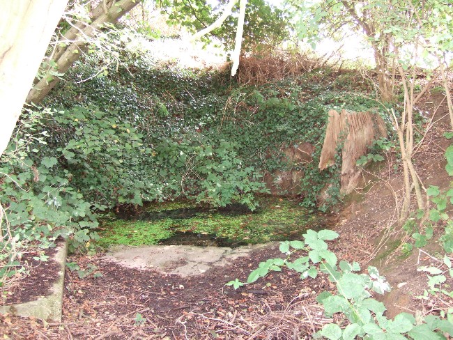
The Runwell (copyright with permission http://www.spiritrealms.co.uk/gallery.htm )
It can be found by taking a road off the A132 (Wickford Road) which leads to Stock (directly opposite the Parish Church), continuing until you reach another minor road to Rettendon. A short way up this road it forks. Take the road to the right & continue until one reaches a minor drive to Poplars Farm (distinctive with its trees each side of the drive). Continue up here until one passes the house to a small piece of tarmac. Here a footpath continues directly in front, continue until one reaches on the left a gate. Enter through here, and head across the field towards a notable tree, and a gap in the hedge. To the left, follow the edge of the field, until one sees another opening into the well. The approach from the south is the only route worth considering as northerly access is blocked by a fence. It can be extremely muddy, so good footwear is advisable.
Archaeology & History
Philip Morant (1763-8) is the first to mention it, suggesting that the settlement is named:
“..from a considerable Running well in the Parish.”
Again, Chandler (1896)—noted in Collins (1986)—emphasises:
“a remarkable spring of water on Poplars Farm, which is always running and has never been known to fail.”
Despite this obvious assumption, Ekwall (1936) suggested that the prefix originates from O.E rune for ‘mystery’ or implying a well possessing a secret of some religious observance. This is suggestive of the strange legends and traditions involved with the site. Alternatively it could derive from hruna referring to the tree trunk—and it does arise in a copse. A roman road runs by here.
The only reference to a religious site appears to be in 1602 when the parish register records ‘Shrine of the Bl. Virgin of RunnyngeWelle’. However, stone remains found over the years around the well may support the idea of a well chapel; these remains were two pieces of limestone window mullion and a piece which appears to be part of a step as well as pieces of Kentish ragstone.
Folklore
According to Bazille-Corbin (1940), Runwell is steeped in lore and legend. One must take these stories as possible antiquarian fancy as there does not appear to be any concrete evidence for them. Doubtless some of it is true, other bits not. He states that in the Sixth Century AD, Christian missionaries Lucus and Lucilus visited Essex and found a scene of paganism here, built a chapel, and rededicated the well to “Our Lady St Mary.” The floor of this chapel had a unique designed cross, with black flint and red strawberry stone, to show the teachings of the tenets of the Christian Faith.
To protect this and collect subsequent devotional gifts, a nunnery, of six members, was developed around the site. They tended to the shrine, well head and the statue of Our Lady, to which many miracles were attributed. Little evidence exists concerning this foundation, but it is believed to have been dissolved in the 16th Century. Locally it is said parts of the nunnery were incorporated into the nearby farm-house ‘The Poplars’. In the 1980s, Andrew Collins, searched for records of this local priory, but found none.
Another legend connected with the well accords that a young nun, Sister Lucy, after renouncing her vows, found the outside world not to her liking and returned in repentance, one snowy night, to the chapel for forgiveness. Yet, upon reaching the chapel steps, she slipped and fell into the icy waters of the well. (cf. The Single or St. Thomas’ Well at Ifield, Kent)
Her ghost is said to haunt the area, preserving perhaps the memories of these past water deities. This is enforced by the belief by some authorities that the well’s dedication indicates a Christianisation of the Iceni goddess Epona. This is supported by these horseshoe-shaped motifs, and that the approach to the well being haunted by a horse.
Andy Collins (1986) was informed that a concrete water tank was installed over the spring. This proved to be inaccurate, but the well was defined by a concrete chamber. Collins thought that this may be the remains of some adaptation for a spa bath, but no hard evidence was forthcoming regarding this.
It certainly had passed through considerable years of neglect, as noted by the Runwell Rector John Edward Bazille-Corbin (1942), who said it was “in much need of dredging and cleaning out.”
The photo shown in Collins’s (1986) work shows a concrete lined rectangular pond, defined by corrugated iron. He was thus responsible for its repair and clearing away the years of neglect, also revealing the concrete rectangular pond, which was reached by a series of steps from its north side. A flight of steps appear to enter the well itself from the front. The body of water is of considerable size and depth and one could easily immerse oneself in it. When I last visited here, the water appeared murky but a sample revealed (apart from the pond fauna) a remarkable clarity.
Within recent years the well appears to have attracted a ‘cult following’, clearly manifesting itself in two ways. One is a seasonal Boxing Day walk to the well started in 1975, which is still undertaken (see link, below). The other more traditionally is the attachment of rags or cloutties to the surrounding shrubbery. Such activity, although probably done by those ‘in the know’ rather than any continuation of any local tradition, is the only such example I have come across in East Anglia—although recent photographs fail to show this and it appears that the tree has been cut down where these have been placed and the area opened up.
References:
Bazille-Corbin, J. E., Runwell St. Mary: A farrago of History, Archaeology, Legend and Folk-lore, 1940.
Collins, Andrew, “Devilish Mysteries at Runwell,” in Essex Countryside Vol. 33 no.431, p38-39, 1985.
Collins, Andrew, The Running Well Mystery, 1986.
Ekwall, Eilert, Studies in English Place and Personal Names, Lund 1931.
Ekwall, Eilert, The Concise Oxford Dictionary of English Place-Names, Oxford 1936.
Morant, Philip, The History and Antiquities of the County of Essex – 3 volumes, London 1763-8 (reprinted by EP: Wakefield 1978).