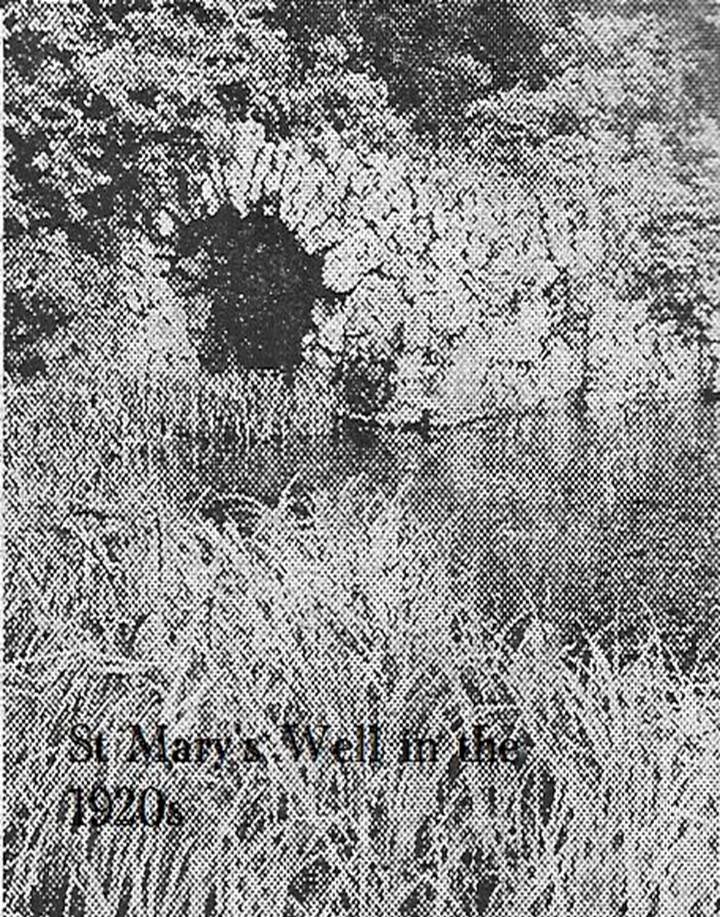
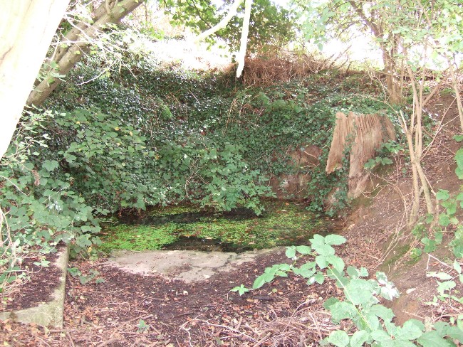
First mentioned in Pipe Rolls and referred to by the founder of Wallingwells Benedictine Priory (founded around 1150 CE) as ‘juxta fonts et rivum fontium’, the site Wallingwell or originally Waldon-by-the-Wells, may be significant. The name refers to ‘bubbling wells’, but whether these wells were dedicated appears to be unknown, although it does seem likely. Indeed, an anonymous article from the Worksop Guardian dated 1929 on the Wallingwell Estate, shows the well arising under a rough stone work arch beside the site of a lake. Close by, appears to be a grotto of a similar construction. The article states that the grotto was built 250 years (from 1929 this suggests a date of 1679 which appears a little too early for this folly, a date in the 18th century being more likely). This was done by Thomas White using stone from petrified springs in Derbyshire. No reference is made of the well, but one assumes that it was built at the same time, but whether White was constructing a folly around an existing traditional site again is unknown.
Baker (2000) refers to the castle folly but fails to reference these sites suggesting that it had vanished. However, grotto and well still exist in the overgrown and forlorn garden to the back of the house. The grotto is well-preserved, although signs of ruination are evident and the urn within has gone.
The internal brickwork
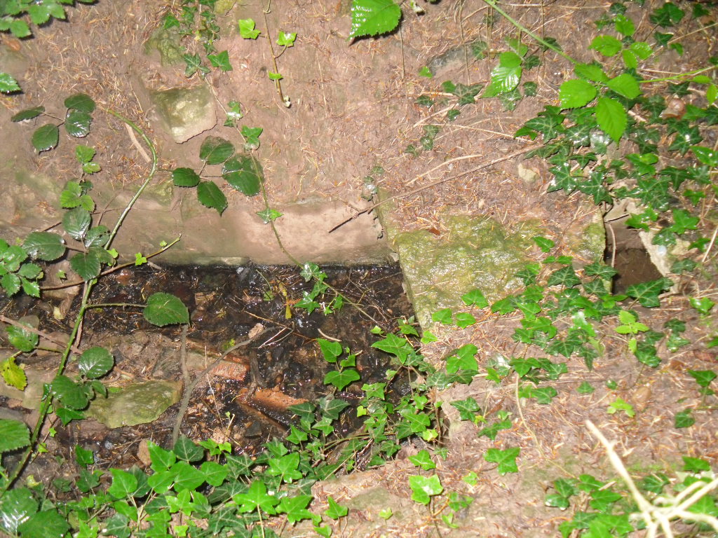
The overgrown well
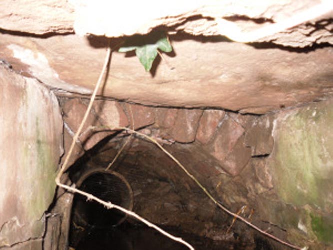
St. Mary’s Well is the most ruined. The archway appears to have fallen or been knocked down but the channel or basin the spring flows into still exists. Observation underneath a flattened stone covering the channel show that the spring flows from a pipe further up and under a series of neat brick arches. It is clear that the well structure was never accessible as it abutts onto the Lake, but was designed to be seen from the other side of the Lake. This view now is difficult due to the considerable plant growth obscuring the sites. It is good to see that the well still exists and hopefully the garden could be restored.
Extracted from R. B. Parish (2009) Holy Wells and Healing Springs of Nottinghamshire
From the village lane at the east end of Brook Street, take the footpath through the first gate and then over the stile into the woods on your left (north). Soon a clearing will appear on the left hand side as you climb the hill. Careful as you scramble down (look for a swing set up by local children) on the left hand side will be the Devil’s Pulpit.
Archaeology & History
The village name deriving from ‘Helmes’, the genitive singjular of the Old English masculine name Helm, or from helmes, the genitive singular of OE helm ‘a helmet, the summit of a hill, a shelter’, so that the name is either ‘Helm’s spring’ or ‘spring at the summit or shelter’—which does rather neatly defines its topography. However, other authorities suggest its gets its name from elm trees which once grew around the wells.
The site has an eerie but not unquiet atmosphere this is possibly due to the stone called the Devil’s Pulpit, a large approximately six-foot high piece of sandstone under which a small spring arises.
Folklore
This Thompson (1999) in his Lincolnshire Wells and Springs notes local opinion thought was St. Helen’s, he said it tasted sweeten than the other waters (a fact that I cannot testify as the spring has appeared to have almost dried up the year I went). Binnall (1845) notes that the spring wells were regarded as possessing curative powers and rags were hung on the surrounding bushes.
The dedication of St Helen is an interesting one and can be seen as an outlier from those found widely distributed in Yorkshire (Whelan & Taylor, 1989), but rare in the adjoining counties of Derbyshire and Nottinghamshire. Harte (2008) in his English Holy Wells suggests that the name is spurious; and Rudkin’s (1936) Lincolnshire Folklore does not refer to it as such. However, in support of the view, I had no problem locally detecting the well using this name in the village (incidentally Harte makes an error referring to the springs as Aisthorpe Springs, these are clearly another site). There was supposed to be a chapel or church associated with the site, of which there is no trace or record.
Taken from R. B. Parish (2012) Holy Wells and healing springs of Lincolnshire
References:
Cameron, Kenneth, The Place-Names of Lincolnshire – volume 6, EPNS: Nottingham 2001.
Harte, Jeremy, English Holy Wells, Heart of Albion: Loughborough 2008.
o’ Neill, Susanna, Folklore of Lincolnshire, History Press: Stroud 2012.
Rudkin, Ethel, Lincolnshire Folklore, 1936.
Thompson, Ian, Lincolnshire Springs and Wells: A Descriptive Catalogue, Bluestone: Scunthorpe 1999.
Whelan, Edna & Taylor, Ian, Yorkshire Holy Wells and Sacred Springs, Northern Lights: Dunnington 1989.
The genuine St. Bertram’s well is not easy to find and I recommend using the OS map carefully. It is reached by taking the footpath that leads off at the left passing the cross out of the village. Follow this until the end of the dry stone walling on the right and then divert from the footpath to the right where the well can be seen. The second well is easily found in the field between the church and the Hall.
Archaeology and History
Bertram is an interesting local saint, dating from around the 7th-8th century. Briefly, he is said to be of Royal Irish lineage but after making a princess pregnant, escaped to England where he sheltered in the woods around Ilam. The story is told by Alexander, a monk, in the 13th century who notes:
“They were in hiding in a dense forest when lo ! the time of her childbirth came upon them suddenly ; born of pain and river of sorrow! A pitiful child bed indeed! While Bertellinus went out to get the necessary help of a midwife the woman and her child breathed their last amid the fangs of wolves. Bertellinus on his return imagined that this calamity had befallen because of his own sin, and spent three days in mourning rites”.
As a result he became a hermit living in a cave in the valley near Ilam. Despite the earliest mention being Plot, the local geography is suggestive that this is the site of an early Christian hermitage site, although no mention of a well is noted in his legends it can be noted. Currently, the well is surrounded on four sides by varying low stone walling, about two feet or so at its highest (although it appears to have been built up and down over the time I have visited the well). The spring flows from a small, less than a foot square chamber, enclosed in stone and set into the bank through a channel in the rubble flow and out along the path towards it.
Since the 1990s, on the first Saturday in August, the Orthodox Church makes a pilgrimage to the site and blesses the well. Interestingly, literature available from the National Trust shop fails to mention this well, but notes a more substantial second St Bertram’s Well close by the church and surrounded by a rectangular stone wall with steps down, the water arises here at greater speed and flows into the nearby River Manifold. Visually it is more impressive and more accessible but whether there is any long tradition of this second well is unclear, but authors such as the Thompsons’s (2004) The Water of Life: Springs and Wells of Mainland Britain and Bord (2008) Holy Wells of Britain appear to have fostered its reputation.
Incidentally, the church boasts the remains of St Bertram’s shrine with foramina and the church yard has two Saxon crosses, making a visit to the village a must for those interested in early medieval history.
Folklore
“St Bertram’s Ash… grows over a spring which bears the name of the same Saint… The common people superstitiously believe, that tis very dangerous to break a bough from it: so great a care has St Bertram of his Ash to this very day. And yet they have not so much as a Legend amongst them, either of this Saint’s miracles, or what he was; onely that he was Founder of their Church”
Such notes Plot (1686) The Natural History of Stafford-Shire, the earliest reference of this fascinating site. By Browne (1888) in his An Account of the Three Ancient Cross Shafts, the Font, and St Bertram’s Shrine, at Ilam, noted that the ash had gone, but the water was still being used. He states that:
“The late Mrs Watts Russell always had her drinking water from it.”
Extracted and amended from the forthcoming Holy wells and healing springs of Staffordshire by R. B. Parish (2008)
The well now lies on private land and feds a trout farm (Beckets Well Trout Farm at The Castle House, Sevenoaks Rd, Otford in Sevenoaks). To find Becket’s Well go along the A225 to the centre of Otford, park in the car park ( in front of the row of terraced shops ) near the Bishop’s Palace. Take a small private road to Castle farm, now as said, a trout farm. Inquire here, if you are able to visit the well, which lies within a complex of fish pools to the east of the farm house.
Archaeology & History
The site has been well recorded in recent centuries, for example an account of 1876, describes the site as, “endorsed within a wall, forming a chamber 15 ft across and 10 ft deep.” Both the chamber’s appearance and shape suggests that is would be ideal for immersions, of which Harper and Kershaw (1923) notes that bath and steps are defied annually by the hop pickers. It is interesting to note that Thorne (1876), with no apparent reference, gives another connection with the saint, suggesting that, “to have used by the saint as a bath.” No subsequent or previous work draws notice to this, so it is likely to be antiquarian fancy. Another more plausible possibility is that it was used by the leper hospital found on this site around 1228. They would have clearly made use of the pure water for medicinal purposes and perhaps indeed used it as a bath.
Kirkham (1948) notes it was suffering from neglect being “now said to be choked up and half full of tins.” This decline would appear to have started a long time ago, as a folly tower, now demolished, was built on Otford Mount (a nearby earthwork), from the well’s stone work. Consequently, this degraded condition prompted excavation in the 1950s by the Otford and District Historical Society; of which the following details of their findings are briefly described.
The report noted that the well consisted of two chambers, with water emerging from two arched outlets into the first of these. This chamber is surrounded on three sides by walls, thirty-five feet by thirteen feet (east end), the walls are eight feet high, and at the same level of the ground. Six steps at the south-east end give access to the well chamber. The sluice wall is five feet high, eight feet wide, and is substantially buttressed on the western front. Water runs through this sluice wall, between steep banks westward, through a lower chamber, twenty-seven feet (north sides), and thirty-five feet (west side). The water then flowed through watercress and finally through an underground, probably Tudor conduit. This conduit then passes through the site of the Palace. This stream once fed a moat, but now discharges into the Bubblestone Brook, a Darenth tributary.
Local common thought was that the well is the remains of a Roman bath house, a belief echoed by its present owner; and a view endorsed by both Ward (1932) and Harper and Kershaw (1923), who note that it “is really a Roman Bath.” This view is further supported by the two surrounding Roman villas, and hence one aim of the excavation was to evaluate this long held claim. Yet, although they showed that the well had gone through considerable renovation and rebuilding over the centuries, no remains could be positively be dated to this period. This renovation, of course, resulted in a rarity of deposits, and hence with a lack of artefacts, the subsequent interpretation was thus difficult.
The excavation was further handicapped by the waterlogged conditions. Both may have influenced the results. Consequently, there are still doubts, and the concept of a Roman origin has not been satisfactorily disproved. The earliest written record is from Otford Ministers accounts of 1440-1, indicating that by then a stone structure existed here, but how old that was again is not clear. It states:
“To a carpenter for two days to make 2 gutters to bring water from the pool of the garden to the moat and for working on and laying another gutter beyond the water course and coming from the fountain of St. Thomas to old garden, 12d; and to a carpenter for one day covering a gutter with timber and cresting it, 6d. And for two masons for 2 days for placing and laying and making a new stone wall of the fountain of St. Thomas, broken for the pipe of the water conduit, 3s, taking between them daily 12d. To five labourers 10 days digging the soil between the said fountain and moat to lay in the leaden pipe of said conduit16s 8d taking each daily 4d.”
The present floor may be ascribed to that period; although it would seem to cover an earlier lower flint floor (again possibly Roman). Between 1520-1520, Archbishop Warkham, pulled down the then existing Manor house and built the Palace, covering four acres. This consequently required a better water supply, and hence the well was improved: the original lower chamber is said to originate from this period. The full purpose of the lower chamber is not clear, but it is believed that it may have housed cisterns giving a greater flow of water. When Henry VIII acquired the Palace from Archbishop Crammer in 1537, he spent money on improvements to the estate, and probably the well. The sluice gate, strengthened by Warham, was now supported by buttresses. These may have supported a conduit house. This was recorded in 1573:
“The condiyte house or well conteyning in length XXXVI foote and in breadth XIX fote to be taken downe and newe sett upp will coste XXX pounds. The pypes conveyinge the water from hence to the offyces and small sesterns to be amended will coste Xiii.”
By the 1600s, the Palace was in disrepair and the well was only used for private consumption by Castle farm. Despite this, restoration still continued and the north, east and south wall saw upper improvements by the 1700s. In the lower chamber a stone west wall was erected on Warham’s brick foundations. By this time, the south wall was beginning to collapse and was rebuilt in the 1800s.
By 1954 repairs were again needed, as the north wall was collapsing. Goodsall (1968) reported that even after its excavation in the late 1950s, the site then enclosed in railings was forlorn and overgrown with weeds. Forty years on, the present condition is similar to that illustrated in the contemporary photo, taken during the excavation: the intervening decades have seen the inevitable degradation, through time, of its infrastructure. Fortunately, the hideous railings have been removed, obviously to erect the trout farm infrastructure, whose water is supplied by the well. The walls appear now comparably greatly overgrown, which has probably preserved them, and the sluice wall, north, south and west walls appear the most ruinous, with the walling falling away towards the sluice wall. The walling was best preserved at the east end.
The clear spring appears to flow rapidly from its source, and has the appearance of being deeper. As stated, it now has now a commercial function, providing good quality water for the raising of trout flowing through a series of fish ponds replacing the cress beds. The owner in the 1990s, a Mrs. Burrows, believed that the well was originally roofed. The results of the excavation did not indicate this although it may be a mix-up with the possibility of a conduit house over the well. She also stated the water stayed the same temperature through the winter and summer, a constant 500 C, certainly beneficial to bathers.
Folklore
One of the best known holy wells among Kent antiquarians no doubt due to the colourful legend associated with it. This tells that whilst living here in the old manor—the ruins of which called the Bishop’s Palace still stand—St. Thomas bemoaned the lack of good water. As a remedy he struck his staff into the ground and clear water gushed forth. This is a familiar folklore motif and we shall see it again referred to at other Kent sites. Perhaps it recalls the saint ordering well digging to provide fresh water and marked the position with his staff! The legends earliest reference is made by Lambard (1571):
“..stake his staffe into the drie ground ( in a place thereof now called Sainte Thomas Well) and immediately the same water appeared, which running plentifully, serveth the offices of the new house to the present day.”
The well was said to be curative, but the exact nature of its curative powers are unknown, and although belief in them was waning by 1800s, rumours of its use continued to the last world war. The Gentlemen’s Magazine of June 1820 gives the only recorded account of a cure and states that:
“an old man, who, crippled by rheumatism, was completely renovated by this bath to health and action of circumstance witnessed by the late Lord Stanhope and several of the neighbouring gentry.”
(Extracted and amended from original blog page, which includes and addition holy well – Colet’s Well –
http://insearchofholywellsandhealingsprings.wordpress.com/2012/01/12/the-holy-wells-of-otford-kent/ – and from the forthcoming Holy Wells and Healing Springs of Kent – references quoted in the piece can be found therein.)
The Runwell (copyright with permission http://www.spiritrealms.co.uk/gallery.htm )
It can be found by taking a road off the A132 (Wickford Road) which leads to Stock (directly opposite the Parish Church), continuing until you reach another minor road to Rettendon. A short way up this road it forks. Take the road to the right & continue until one reaches a minor drive to Poplars Farm (distinctive with its trees each side of the drive). Continue up here until one passes the house to a small piece of tarmac. Here a footpath continues directly in front, continue until one reaches on the left a gate. Enter through here, and head across the field towards a notable tree, and a gap in the hedge. To the left, follow the edge of the field, until one sees another opening into the well. The approach from the south is the only route worth considering as northerly access is blocked by a fence. It can be extremely muddy, so good footwear is advisable.
Archaeology & History
Philip Morant (1763-8) is the first to mention it, suggesting that the settlement is named:
“..from a considerable Running well in the Parish.”
Again, Chandler (1896)—noted in Collins (1986)—emphasises:
“a remarkable spring of water on Poplars Farm, which is always running and has never been known to fail.”
Despite this obvious assumption, Ekwall (1936) suggested that the prefix originates from O.E rune for ‘mystery’ or implying a well possessing a secret of some religious observance. This is suggestive of the strange legends and traditions involved with the site. Alternatively it could derive from hruna referring to the tree trunk—and it does arise in a copse. A roman road runs by here.
The only reference to a religious site appears to be in 1602 when the parish register records ‘Shrine of the Bl. Virgin of RunnyngeWelle’. However, stone remains found over the years around the well may support the idea of a well chapel; these remains were two pieces of limestone window mullion and a piece which appears to be part of a step as well as pieces of Kentish ragstone.
Folklore
According to Bazille-Corbin (1940), Runwell is steeped in lore and legend. One must take these stories as possible antiquarian fancy as there does not appear to be any concrete evidence for them. Doubtless some of it is true, other bits not. He states that in the Sixth Century AD, Christian missionaries Lucus and Lucilus visited Essex and found a scene of paganism here, built a chapel, and rededicated the well to “Our Lady St Mary.” The floor of this chapel had a unique designed cross, with black flint and red strawberry stone, to show the teachings of the tenets of the Christian Faith.
To protect this and collect subsequent devotional gifts, a nunnery, of six members, was developed around the site. They tended to the shrine, well head and the statue of Our Lady, to which many miracles were attributed. Little evidence exists concerning this foundation, but it is believed to have been dissolved in the 16th Century. Locally it is said parts of the nunnery were incorporated into the nearby farm-house ‘The Poplars’. In the 1980s, Andrew Collins, searched for records of this local priory, but found none.
Another legend connected with the well accords that a young nun, Sister Lucy, after renouncing her vows, found the outside world not to her liking and returned in repentance, one snowy night, to the chapel for forgiveness. Yet, upon reaching the chapel steps, she slipped and fell into the icy waters of the well. (cf. The Single or St. Thomas’ Well at Ifield, Kent)
Her ghost is said to haunt the area, preserving perhaps the memories of these past water deities. This is enforced by the belief by some authorities that the well’s dedication indicates a Christianisation of the Iceni goddess Epona. This is supported by these horseshoe-shaped motifs, and that the approach to the well being haunted by a horse.
Andy Collins (1986) was informed that a concrete water tank was installed over the spring. This proved to be inaccurate, but the well was defined by a concrete chamber. Collins thought that this may be the remains of some adaptation for a spa bath, but no hard evidence was forthcoming regarding this.
It certainly had passed through considerable years of neglect, as noted by the Runwell Rector John Edward Bazille-Corbin (1942), who said it was “in much need of dredging and cleaning out.”
The photo shown in Collins’s (1986) work shows a concrete lined rectangular pond, defined by corrugated iron. He was thus responsible for its repair and clearing away the years of neglect, also revealing the concrete rectangular pond, which was reached by a series of steps from its north side. A flight of steps appear to enter the well itself from the front. The body of water is of considerable size and depth and one could easily immerse oneself in it. When I last visited here, the water appeared murky but a sample revealed (apart from the pond fauna) a remarkable clarity.
Within recent years the well appears to have attracted a ‘cult following’, clearly manifesting itself in two ways. One is a seasonal Boxing Day walk to the well started in 1975, which is still undertaken (see link, below). The other more traditionally is the attachment of rags or cloutties to the surrounding shrubbery. Such activity, although probably done by those ‘in the know’ rather than any continuation of any local tradition, is the only such example I have come across in East Anglia—although recent photographs fail to show this and it appears that the tree has been cut down where these have been placed and the area opened up.
References:
Bazille-Corbin, J. E., Runwell St. Mary: A farrago of History, Archaeology, Legend and Folk-lore, 1940.
Collins, Andrew, “Devilish Mysteries at Runwell,” in Essex Countryside Vol. 33 no.431, p38-39, 1985.
Collins, Andrew, The Running Well Mystery, 1986.
Ekwall, Eilert, Studies in English Place and Personal Names, Lund 1931.
Ekwall, Eilert, The Concise Oxford Dictionary of English Place-Names, Oxford 1936.
Morant, Philip, The History and Antiquities of the County of Essex – 3 volumes, London 1763-8 (reprinted by EP: Wakefield 1978).
Holy Well (destroyed): OS Grid Reference – TQ 6538 7081
Also Known as:
St. Thomas’ Well
Shingle Well
Archaeology & History
Sadly the site is gone no longer in existence it was in the roadway along the Roman Watling Street, at its junction with Church Lane, where it joins the relatively recently named Hever Road with Mailings Cross.
Local opinion, erroneously believes that its name derives from there only being one well in the district, but it originates from its substrate, being once called ‘Shinglewell’ describing the substrate. It ended its days as a traditional winch well, with a depth of 150 yards. Watt (1917) described the draw well as having a sign, reading ‘This water is not fit for drinking’— the result of contamination by a nearby stagnant pond. This wooden framework was removed during the First World War, when the well was filled in and domed over. Later, in 1935, a granite slab inscribed with: ‘Site of the Ancient Well, Singlewell Parish or Ifield’ was placed there. Unfortunately, this was removed by the County Council in 1952, and along with the combination of road improvements, the site was largely forgotten.
Folklore
Recorded in a Latin MS and translated by the Rector of Ifield between 1912-1935, the Rev K. M. Ffinch tells of a tradition in great detail, and the following is a brief resume. The legend involves a village girl called Salerna, who is said to have ‘thrown’ herself down the well after being accused of stealing some cheese. Yet, as she fell, she cried out for St. Thomas to save her from her impending doom, and upon finishing her plea, landed on some planks lying at the bottom of the well. They broke her fall, and thus saved her from her dreadful fate. She was then subsequently rescued and because of the ‘miracle’ the well was dedicated to the saint.
The incident is said to have occurred soon after St. Thomas’s martyrdom, and is said to have been one of his first miracles. The name ‘Salerna’ suggests a Roman origin, supported by its location along Watling Street, a Roman Road. Bayley (1978), using a low-land British dialect, which he believed survived until this century, states that ‘Salire Naias’ is ‘the water nymph, who springs forth and runs down’. Consequently, the story of St. Thomas miracle may have been introduced to remove the pagan tradition and refocus the beliefs of the people using a local saint.
References:
Bayley, M.,(1978) Ancient, and Holy and Healing Wells of the Thames Valley, and their Associations.
Ffinch, K.M., (1957) The History of Ifield and Singlewell
Parish, R.B., (1997) “The Curious Water-lore of Kent II: Ghosts, Fertility and Living Traditions”, in Bygone Kent, Volume 18, pp.427–32.
Watt, F., (1917) Canterbury Pilgrims and their Ways
(Extracted from the forthcoming book Holy Wells and Healing Springs of Kent)
Often noted under Lower Burnham, although this is a hamlet and not strictly the parish, is in Haxey. The spring can be found by taking the footpath after Starkey’s farm, top of Holy Well lane, with Holy Well House the nearest dwelling.
Archaeology & History
Holy Well, Haxey
Potentially if Hunt (1923) quoted in Hills (1967) is to be believed, this is the most famed holy well in the county, as he believes that this was the site where King Oswald—later St Oswald—was slain and here the well was St Oswald’s Well rather than at Oswestry. He notes that:
“The Holy Well at Lower Burnham in the parish of Haxey is supposed to mark the site where King Oswald fell. People took away the soil until a deep hole was formed which filled with water…It has been known for 1300 years as the Holy Well, and annual feasts were held near it until recent years. This confirms the Ven. Bede’s statement about the sanctity of the soil in the eyes of the people.”
According to Garner (1991) by the early 19th century the well’s popularity had waned and the spring fell into private ownership and the water was used to run two water mills, and as such a gully of considerable depth constructed. However the spring did not produce enough continuous water and the scheme failed. A similar attempt was made by Rev. Thomas Skipworth Rector of Belton was more successful but only because a dam was constructed although still the power was not great enough. Interest in the well had not completely disappeared, and an announcement in 1875, in the Epworth Bells stated:
“Firmly believing in the efficacy of the Burnham water in the cure of some outward bodily complaints, we sometime since urged the importance of making that water once more available to the public, and at the same time we urged the desirability of the public availing themselves of the water.”
Responding to this plea, a group of local men, Cooper, Starkey, Ducker, Skelton, Meggitt and Templerton came together to ‘re-open the well’ It had been for years only a dry, roughly rectangular, hollow but ‘within minutes of digging, water gushed out, and the hollow filled.’ No evidence of constructional material was seen but the landowner, Mr. Lockwood, agreed to allow the well to be kept open and the water to be freely available when he did not have cattle in the field, as such the well was fenced in probably as local people reported in the Crowle Advertiser (1960) with white railings. Indeed, up until the 1940s the well remained fenced off with barbed wire as a cattle water place and at some point it was filled in.
This meant that the well had again fallen into disused and its exact location was perhaps becoming unclear, when in the 1960s when three Epworth men, Frank and David Lindley with Jack Warriner. A report in the Crowle Advertiser of 1960 noted that:
“At a spit depth, what seem to be known locally as water stones began to be turned up; at about two feet six there was a promising slab, followed by another, at a little deeper level; and after discovery of several hand-made bricks had dispirited the diggers somewhat, three more irregular shaped stones of considerable size were scraped clean of the mud that overlaid them. By now there was bared to view what could have been the stepped entrance to the well which from visual testimony of old residents, the explorers hoped to find.”
This stepped entrance consisted of eight steps according to local people. The group then discovered at about four feet timber was found and on this two corner stones were found rested. This was thought to have been the remains of the enclosure which went around the well.
In March 1961 another attempt was made to open the well in view of a pilgrimage by the Lincoln Diocesan Youth Pilgrimage, this time the excavators had gone twice as deep and the strata of waterstone was hit, but no evidence of a constructed well. This was not a concern of the Vicar of Owston Ferry, Canon L. D. Ravins who was of the opinion that an actual construction would have been unlikely if the above description by Hunt was to have happened. This time according to the Crowle Advertiser:
“Both he and Canon Ravins feel that the water may well have medicinal qualities (they noticed they say an unmistakably sulphurous smell from it during the excavations) and they are intending to have the chemical analysis made.”
However, the analysis did not reveal any sulphur but it did have Magnesium and Calcium sulphates and Calcium bicarbonate all linked to spa waters and hence verifying its medicinal role. The well was visited by the pilgrimage and Garner (1991) recollects that a white timber enclosure was placed around the site with a sign proclaiming ‘The Holy Well’ according to him the ‘whole site now barely discernible save for a lone willow sentinel-like over the place revered by myriad generations in days long since past.’
However, this was not the case when I visited the site and found a large pool with a pipe at one end, from which a channel appeared to flow. Although Garner (1991) noted a ‘few elder citizens of Burnham strongly favour its position a few metres south of the spot popularly referred to”.
Folklore
However this name has not been recorded and the site is best known simply as the holy well. This site was, according to Gutch & Peacock (1908),
“ …dedicated to the ever-blessed Redeemer, and on the festival of His Ascension was supposed to possess the power of healing all sorts of deformities, weaknesses, and cutaneous diseases in children, numbers of which were brought from all parts to be dipped in it on that day.”
The earliest mention appears to be Peck (1809) who stated:
“a Spring called the Alley Well of very cold water which was very much resorted to by the people in their neighbourhood, being very proper for those of a weakly habit.”
Stonehouse (1839) notes:
“about one hundred and twenty years ago, the concourse of visitors was so great that a Village Feast was held at the same time… and at a much later period conveniences were annually made for the use of the bathers, and gingerbread-stalls and other slight reflections were provided on the spot. This practice has, however, of late years fallen altogether into disuse… The spring now appears in a dirty and neglected state.”
The fame of the spring led to it being immortalised in Hamilton’s novel Captain John Lister where the titular hero watches during the early morning of Haxey Fair, a melancholy procession through the main street of women, accompanied by diseased and deformed children. In the book, the innkeeper explains by saying:
‘They are going to the Holy Well at Nether Burnham. ‘Tis a famous spring, and has been many ages, and on this day there is virtue in the water to cure almost any disease or sickness in a child, if be dipped before noon…out of Nottinghamshire and Yorkshire and I don’t know where all.’
(Essay taken from R.B. Parish Holy Wells and healing springs of Lincolnshire)
References:
Garner, J. R. (1991) Burnham – the story of an Axholme village.
Gutch, E. & Peacock, M. (1908) Country Folklore Vol. VI: Folklore of Lincolnshire
Hills, P.J. (1967) The Holy Well of Burnham the site of the Battle of Maserfield-the identification re-examined.
Stonehouse, W.B. (1839), The History and Topography of the Isle of Axholme.
Various anonymous cuttings from Crowle Advertiser (1960)