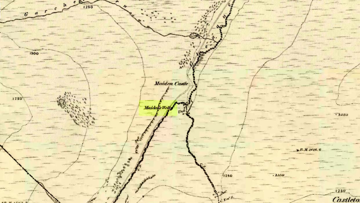
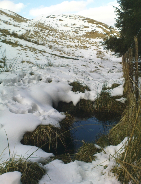
Follow the same directions as if you’re going to the Maiden Castle fairy hill. About 100 yards before reaching the hill, on the right-hand side of the footpath between the tree-line and the small stream, you’ll see a small pool of water. That is the Maiden’s Well.
Archaeology & History
Maiden’s Well & the fairy haunt of Maiden Castle hill behind
A mile northeast of the faerie-haunted Butter Well, just on the border of Clackmannanshire and Perthshire, we find this little-known magickal spring. More than a century ago, the story of this remote well was heard about hundreds of miles away by one Rev. Andrew Clark of Oxford, “who heard it from the late sexton of the parish of Dollar, in the county of Clackmannan” and who then mentioned its existence to the great Victorian Celtic scholar John Rhys (1901), who subsequently wrote of it as being “a fine spring bordered with flat stones, in the middle of a neat, turfy spot”, close to the legendary faerie hall of Maiden Castle. The well itself has now given birth to a pool whose waters, so folklore and text ascribe, always provides good clear water even in the height of summer.
The local historian Hugh Haliburton (1905) told that the well obtained its name from a princess who was held captive in Castle Campbell in the valley to the southwest, and that she was sometimes allowed out of prison by her captors, to walk to the well and drink its waters.
Folklore
This tale has been mentioned by various historians and, no doubt, has some religious relevance to the faerie lore of Maiden Castle, close by, Bruce Baillie (1998) told:
“A story associated with it states that it is haunted by the spirit of a beautiful maiden which only appears at night and, should any male attempt to kiss her, coronary thrombosis occurs.”!
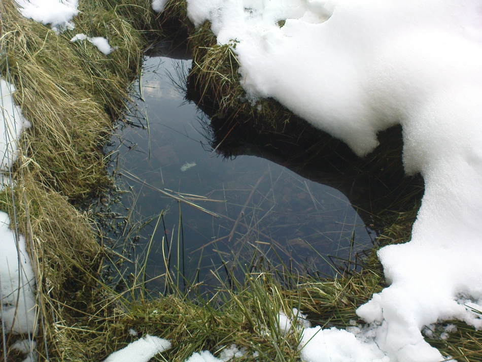
The Maiden’s Well pool
Earlier accounts tell of magickal rites that could be used to invoke the beautiful maiden, but once again dire consequences may befall the poor practitioner.
To this day, local people visit the well and make offerings to the spirit of the waters, as you’ll see if you come here. Some of the remains here are very old; and a visit not long ago indicated that offerings were made even when surrounded by depths of snow in the middle of a freezing winter.
References:
Baillie, Bruce, History of Dollar, DMT: Dollar 1998.
Fergusson, R. Menzies, The Ochil Fairy Tales, Clackmannan District Libaries 1985.
Follow the same directions to reach the superb Badger Stone carving, and from here take the footpath that runs downhill. You’ll cross another footpath about 100 yards down the moor, but just keep walking down the path and you’ll notice the small copse of woods ahead of you. As the footpath begins to swerve roughly away, northeast, heading away from the said woodland, keep your eyes peeled on your left for a reasonably large but flattish rock close to the ground (in summer it’s surrounded by bracken) about 75 yards away. That’s your target!
Archaeology & History
Of the hundreds of cup-and-ring stones on Ilkley Moor and district, this is one of my personal favourites! I first visited the stone in 1977 as a young teenager and was mightily impressed by the unusual nature of the design here — and that impression still remains. Aswell as possessing the usual cups and rings, the Barmishaw Stone is one of just a few rocks also possessing a sort of ‘ladder’ design or linear pattern within the overall carving: an insignia echoed on the nearby Willie Hall Wood carving, the Piper Stone, and also on the Panorama Stones. As with the ‘ladders’ on the Panorama carving, those found here at Barmishaw are very eroded and are increasingly difficult to see during the daytime (the best time to notice them is usually around sunrise or sunset, and particularly when the rock itself is wet).
The carving has been described many times, albeit briefly, by a number of writers. In John Hedges (1986) fine survey he said the following:
“Medium sized flat-topped rock…fairly smooth grit, sloping slightly east to west, covered with carvings, some of which are very worn. Slanting sunshine needed to detect them. About twenty-four cups, at least nine with rings or incomplete rings, two with multiple grooves half round and continuing straight down, one of them incorporating ‘ladder.’ Five other ‘ladders’ – in a good light. Cups mostly deep and clear.” A few years later, Boughey & Vickerman (2003) echoed much of Mr Hedges description, though noted that of the 24 cups with their rings, one possessed a triple ring.
Alan Davies’ illustration
Like so many cup-and-ring stones, they have given rise to hosts of fascinating theories and ideas — one of which is based on mathematics and metrology. In the 1980s, Alan Davies (1983, 1988) surveyed the Barmishaw Stone — and other carvings on Ilkley Moor — to explore the possibility that the cups and rings were laid out according to a basic unit of measure, the Megalithic Inch (MI), as proposed by Alexander Thom some years earlier. Although Davies’ work showed that such a primary unit of measure wasn’t to be found universally, his research at the Barmishaw Stone indicated “significant evidence for quanta of…3 MI,” although this occurred “when the analysis is restricted to only ringed cups.” Despite this, Davies thought that the existence of the Megalithic Inch was evident in this and other carvings on the moors, stating that:
“The repeated emergence of the significance of ringed cups, and the fact that all putative quanta seem to bear a simple numeric relation to each other do not seem to be coincidental.”
Although it has to be said that the selectivity of data in Davies’ research is more indicative that the Megalithic Inches in the the carvings was due, neither to chance nor mathematics, but more that the implements used to carve the rocks and the size of the hands of the people doing the carvings was pretty uniform and so, as a result, would give an obvious window of numeric similarities that can easily be mistaken as a deliberate metrology. These simplistic factors need assessing. In modern trials that we’ve done carving cup-markings, we’ve found them to be of similar size to those carved in prehistoric times—as you’d expect.
Barmishaw Stone (after Hedges, 1986)Barmishaw stone (Cowling 1946)
The ladder motif central to this carving may have related to early religious and ritual events here. Across the world, indigenous cultures commonly relate the ‘ladder’ to be a symbol of ascension, both by shamans, mystics and during rites of passage. The symbol represents the journey of the soul to and from supernatural realms. To discount this possibility at the Barmishaw Stone would be shortsighted.
The carving was very probably painted when our neolithic ancestors gathered here, much as Australian aborigines still do to their carvings using lichens and other plant dyes, with the respective ladders and lines changing colour where movements between worlds or shifts of attendant spirit occurred. By virtue of the its very name, I consider this rock to have been considerably important; the “ghost” aspect to barmishaw being a typically misconstrued aspect of ‘spirit’.
Folklore
This excellent cup-and-ring marked stone probably derives its name from the old dialect words “barm i’ t’ shaw”, meaning “ghost in the wood” stone. Whatever guise the attendant spirit of this rock may have had has long since been forgotten; though spectral accounts from the beginning of the nineteenth century until modern times may give us clues. There have been several reports of green-coloured elemental creatures around the area between here and the White Wells sacred spring a short distance to the east. The most recent account, from 1987, took on the modern mythic form of a little green man from space, with attendant UFO to boot! The Barmishaw Hole nearby was a place where faerie-folk used to live. Excesses of geological faulting and water makes the magickal nature of this place particularly potent.
References:
Allen, J. Romilly, “The Prehistoric Rock Sculptures of Ilkley,” in Journal of the British Archaeological Association, volume 35, 1879.
Allen, J. Romilly, “Notice of Sculptured Rocks near Ilkley,” in Journal of the British Archaeological Association, volume 38, 1882.
Bennett, Paul, “Cup-and-Ring Art”, in Towards 2012, volume 4, pp.83-92, 1998.
Bennett, Paul, The Old Stones of Elmet, Capall Bann: Milverton 2001.
Boughey, Keith & Vickerman, E.A., Prehistoric Rock Art of the West Riding, WYAS: Wakefield 2003.
Cowling, E.T., ‘A Classification of West Yorkshire Cup and Ring Stones,’ in Yorkshire Archaeological Journal 1940.
Cowling, E.T., Rombald’s Way: A Prehistory of Mid-Wharfedale, William Walker: Otley 1946.
Davis, Alan, ‘The Metrology of Cup & Ring Carvings near Ilkley in Yorkshire,’ Science Journal 25, 1983.
Davies, Alan, ‘The Metrology of Cup and Ring Carvings,’ in Ruggles, C., Records in Stone, Cambridge University Press 1988.
Eliade, Mircea, Patterns in Comparative Religion, Sheed & Ward: London 1958.
Hedges, John (ed.), The Carved Rocks on Rombalds Moor, WYMCC: Wakefield 1986.
Wright, Joseph, The English Dialect Dictionary – volume 1, Henry Frowde: Oxford 1905.
Park at Stump Cross Caverns on the B6265 road, then walk down the road for 200 yards till you reach the track on your left running over the fields in the direction towards Simon’s Seat. Walk on the track for about 600 yards until there’s a change of direction in the adjacent walling and then watch out for the dirt-track on your right, curving towards the small valley (if you hit the Skyreholme Wall carving (413), you’ve gone 100 yards past the turn-off). Go on here until you see the overgrown track on your left into a small disused quarry, and head right, down the grassy slope, checking out the few stones ion front of you 20 yards down. You’re damn close!
Archaeology & History
Carving no.404 (after Boughey & Vickerman)
A simplistic carving that was first described by fellow antiquarian Stuart Feather (1964), this is one of at least four cup-marked stones in a small group here, above the valley of Skyreholme Beck — better known at this part of the valley as the Troller’s Ghyll, haunt of various heathen lore. Although some of the carving has now been covered by the growing Earth, you can still see the majority of the design.
It is a flat, roughly triangular stone described by rock art students Boughey & Vickerman (2003) and having 13 cup-markings on it. To get a full look at the entire carving, you may have to roll a bit of the turf away from one side of the rock.
Folklore
Although we have no lore relating to this specific carving, the small valley over which this carving looks was long known as the abode of the legendary bharguests, or black dogs: underworld creatures of earlier heathen myths. Faerie lore can also be found a short distance further up the same stream.
References:
Boughey, Keith & Vickerman, E.A., Prehistoric Rock Art of the West Riding, WYAS: Wakefield 2003.
Tumulus (destroyed): OS Grid Reference – SD 696 208
Also Known as:
Whitehall Tumulus
Ashleigh Barrow urns (after John Dixon)
Archaeology & History
Early accounts of this site tell of its destruction in the 19th century, but a modern reconstruction of the site has been made close to where it once stood. And this tomb sounded quite impressive! Within the ‘tomb’ were found a large number of urns, one of which was curiously empty. In John Dixon’s excellent Journeys through Brigantia (2003) work he told that,
“Contemporary reports about its excavation state that it was of circular form about 30 yards in diameter, being formed on a naze or promontory of an undulating plateau overlooking the Darwen valley. Its height was said to vary between 10 to 12 feet on the east side and between 2 or 3 feet on the west, the centre being about 6 feet in diameter and consisting of a slight hollow.
“Ten interments appear to have been made, one being just a heap of burnt bones, the others, having been enclosed in urns, the majority of which are badly broken, consisted of ashes and fragments of bone together with unrecognizable pieces of bronze. Two urns also contained ‘incense cups’ and another a 7½-inch bronze knife or dagger.
“The design of the urns is similar to those from the Middle Bronze Age… All but two of the urns were found within an area 21 feet by 14 feet, whilst one was 40 feet away. They were, with one exception, placed in the Earth with the orifice pointing upwards and were covered with slabs, the depth at which they were found varying from 1 to 2 feet.”
Remains of the urns can be seen on display in the Darwen Library.
Folklore
Once again in John Dixon’s (2003) fine Journey’s through Brigantia volume, we read of folklore relating to the respect of the dead which local people used to give this old tomb, telling:
“Many superstitions were attached to the barrow and its destruction in the 1860s, with the country people speaking of the place being haunted by ‘boggarts’ and children having been known to take off their clogs or shoes and walk past it barefoot in the night time.”
References:
Dixon, John, Journeys through Brigantia – volume 11: East Lancashire Pennines, Aussteiger Publications: Barnoldswick 2003.
From Brodick, walk up the Glencloy dirt-track towards the friendly Kilmichael Hotel but turn off on the left shortly before hand, up another footpath, crossing the stream until you eventually reach the derelict house which was built into the edges of this old tomb. Upon the small rise above here, at the edge of the forestry commission trees, you’ll notice the overgrown ruins of the old tomb.
Archaeology & History
The remains here are somewhat overgrown and ramshackled, but I still like this place and in my younger days used to spend a lot of time here. It can get quite eerie in some conditions and seems to validate some of the folklore said of it. The site was described in Balfour’s (1910) magnum opus as:
“Situated in Glen Cloy, on the moor above Kilmichael House, close to a cottage called Glenrickard. There are no traces of a cairn or of a frontal semicircle. The chamber is formed of rather light flags, with their upper edges nearly on the same level, so that the monument is more like a series of cists than a chamber. The roof and end stone have gone; there are two portal stones, but the gap between them is only 7 inches. The chamber is directed N and S, with the portal to the south. There have been three compartments, but they are rather smaller than usual, the third from the portal being only 3 feet 10 inches long by 2 feet 2 inches broad. Two feet 6 inches from this compartment is another cist, which is possibly a short cist representing a secondary interment, and 10 feet farther north is a second ruined cist placed at a different angle. This last has the appearance of a short cist, but it is not carefully constructed and differs little from the component compartments of the chamber. The structure is anomalous, and may perhaps be regarded as representing a phase of degeneration in the transitional period.”
Glenrickard ground-plan (after Henshall 1972)Glenrickard on 1868 map
Audrey Henshall (1972) later descried the site in greater details in her own magnum opus and told that “two rude clay urns of the primitive flower-pot pattern (were) found in the chamber”, along with “calcined bones, said to have been in the two vessels.”
Folklore
Said by local people to be haunted, the spirit of the tomb was said to have been disturbed upon the building of the derelict house below it. Ghosts of a middle-aged couple and young child have been seen in the house; whilst the spirit of the site can generate considerable fear to those who visit the place when it is ‘awake.’ To those who may visit this out-of-the-way tomb, treat the site with the utmost respect (and DON’T come here and hang a loada bloody crystals around the place in a screwy attempt to “clean” the psychic atmosphere of the place. If you’re that sort of person, don’t even go here! The spirit of the place certainly wouldn’t want you there).
References:
Balfour, J.A., The Book of Arran: Archaeology, Arran Society: Glasgow 1910.
Henshall, Audrey Shore, The Chambered Tombs of Scotland – volume 2, Edinburgh University Press 1972.
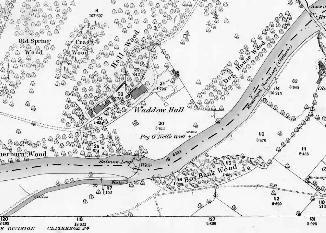
The well is located in the grounds of Waddow Hall close by Brungerley Bridge, near Waddington, in the Ribble Valley. The hall is just off the B 6478 road about three-quarters of a mile south-east of Waddington village. It is on private land, but you can see the well by walking along a footpath at the western side of the hall running along the banks of the River Ribble at the southern side of the hall grounds.
Folklore
The legend originates from the 18th century although the well is a pre-Christian spring. According to this most often told ‘legend’ Peg O’ Nell was a servant girl at Waddow Hall. However, she often fell out with her masters, the Starkie family, often quarreling with and being disobedient to them. One night, in particular, Peg had a blazing row with Mistress Starkie after saying she didn’t want to fetch water from the well; the mistress was so enraged that she shouted at the servant saying “I hope you fall and break your neck”. At a later date this came true when on a particularly icy night Peg went to fetch water from the well, but on her way there she slipped on some ice and fell into the River Ribble, at a treacherous spot, and did indeed break her neck. From that time on there seems to have been a curse on the Starkie family – anything and everything that happened at the hall was blamed on Peg, or her ghost, which was now haunting the house and grounds. Mistress Starkie became so fed up with the curse that she took an axe and chopped off the head of a statue that had earlier been placed beside the well in memory of poor Peg. Thinking that by doing this the curse would come to an end, and it seems to have done just that, because afterwards peace and quiet seems to have come upon the hall.
Peg o’ Nells Well on 1884 map
Another legend or tale says that Peg dwelt by the well, perhaps as a kind of sprite, but that she caused a local Puritan preacher to fall into the River Ribble. As a punishment for this dastardly trick the head of the statue was chopped off. Folklore says that a water spirit or “sprite” lived in the well which was connected underground to the nearby River Ribble.
But the truth about this seems to be that the headless statue is that of St Margaret of Antioch who was beheaded for her faith in the early centuries of Roman rule. St Margaret’s feast day was on 20th July. Apparently, her statue was brought to Waddow Hall from either Sawley Abbey or Whalley Abbey where it had stood in its own niche, or possibly it came from a local Catholic church. The headless statue appears to be holding a bible in one hand; so it was probably placed at the side of the well in order to make the well holy and sacred to pilgrims who used to visit the site for healing purposes on the saint’s day. The head of the statue used to reside in an upstairs room at the hall, but it was lost for a time, only to be re-discovered and embedded into a wall at Brungerley farm not far from the bridge.
But we may never know what really did happen here because legend and folklore have become mixed in with other tales that may, or may not, be true. The holy well stands in a meadow in the hall grounds and is a square-shaped hollow in the ground where water still flows, possibly fed by the river close by. The statue still stands at the side; and fencing now surrounds this sacred site. The hall and grounds are still said to be haunted by a ghost, but whether it is Peg’s ghost we do not know, because this particular ghost is said to be hooded ? The curse itself used to claim a victim once every seven years; the screaming spirit of Peg would rise up from the murky waters of the river on stormy nights – an animal could apparently suffice as a victim, rather than a human. This story was almost certainly made-up probably to frighten the Starkie family who it was originally aimed at.
Waddow Hall is now a Training and Activity Centre, but it used to be a Centre for girl guides and during the second world war it was an isolation hospital.
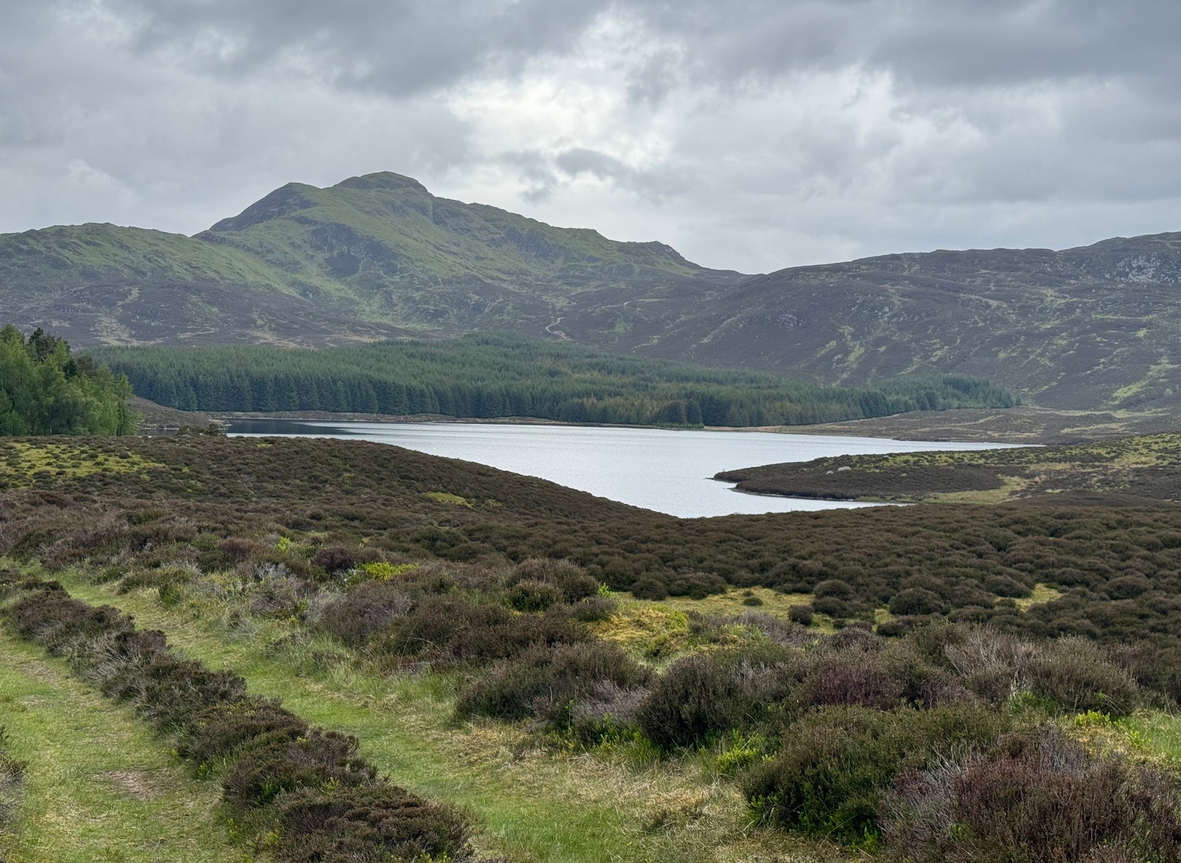
Although this upland loch is today renowned as little more than a decent fishing spot, the waters here were long known to be haunted and the abode of a legendary water spirit. In local tradition, the loch is said to be named after “an ancient Chief of Pictish origin” — whose burial mound is nearby — and in James Kennedy’s (1928) fascinating folklore work he also told that,
“Loch Dereculich was the habitation of a ‘Tarbh Uisge’ (water bull), the dangerous water demon… This dreaded monster, as the Norwegian peasant will gravely assure a traveller, demands every year a human victim, and carries off children who stray too near its abode… Less than one hundred and twenty years ago, the Loch Derculich Water Bull was seen sauntering along its shores. At peat-making times it was observed very frequently.”
References:
Kennedy, James, Folklore and Reminiscences of Strathtay and Grandtully, Munro Press: Perth 1928.
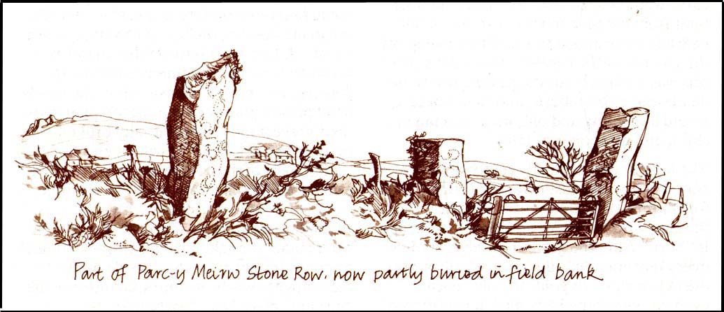
This is an impressive and well-known megalithic stone row, found just 4-5 miles inland from the coastal town of Fishguard. The drawing here is used courtesy of Elizabeth Haines, landscape artist, and gives a fine representation of the site as I’m sure you’d agree! Consisting of at least eight standing stones — four still upright and four laid down — aligning northwest to southeast, the tallest stone stands at the southerly end measuring 11 feet tall. The stone row is found in a region rich in prehistoric remains. Aubrey Burl (1993) said of the place:
“Four of the eight stones in this unusual row still stand, trapped in a field-wall, tow of them now gateposts. Thom suggested that the line, 131ft (40m) long, was laid out downhill towards the WNW and the minor northern moonset just north of Mount Leinster ninety-one miles away across the Irish Sea.”
Quite a distance! And perhaps because of this, Burl thought that the nature of this line of stones was more archaeological than astronomical, with its focal point being more likely up the slope to the ESE instead.
Folklore
There was once an adjacent chambered tomb here which, when it was “destroyed for a house in 1844 brought the owner no luck” (Thom, Thom & Burl 1990) – which is damn good to hear! There was a piece of folklore mentioned by E.L. Barnwell (1868) and other writers that the fields here marked the fall of three Welsh princes in the Battle of Mynydd Carn in 1084. In Roger Worsley’s (1988) fine tour of Pembrokeshire’s historical sites, he tells how these megaliths in the “field of the dead” are also haunted, saying:
“A local tale tells of Ladi Wen, a ghostly White Lady wandering about the fields at night, and who will kill anyone who ventures near; it was enough to keep villagers away from the site well into this century, though the stone row is over five thousand years old.”
References:
Barber, Chris & Williams, John Godfrey, The Ancient Stones of Wales, Blorenge: Abergavenny 1989.
Barnwell, E.L., “Alignments in Wales,” in Archaeologia Cambrensis, volume 14, 1868.
Burl, Aubrey, From Carnac to Callanish, Yale University Press 1993.
Thom, Alexander, Thom, A.S. & Burl, Aubrey, Stone Rows and Standing Stones, BAR 560: Oxford 1990.
Worsley, Roger, The Pembrokeshire Explorer, CCP: Abercastle 1988.
Tumulus (destroyed): OS Grid Reference – TA 0422 7726
Archaeology & History
A once-impressive haunted burial mound on the southern edge of Folkton parish, all that remains of the place now are aerial images showing the ghostly ring of its former site. Commenting on the destruction of this burial mound before he had chance to give it his full attention, in William Greenwell’s (1877) magnum opus he wrote the following:
“Elf Howe had been removed to a great extent, and the grave had been dug out before I had an opportunity of examining it. I however got an account of what was discovered from the foreman on the farm, and I was able personally to inspect a small portion which had not been disturbed. The barrow had been 60ft in diameter and 6ft high, and was made of earth and chalk. Near the centre a deposit of burnt bones was met with, over which some large flints were placed; this was at a depth of 4ft, and as a great quantity of burnt earth was observed immediately round the bones, it is probable that the body had been burnt on the spot where the bones were placed. Two unburnt bodies were found on the south side of the mound, with one of which a vessel of pottery was associated. At a distance of 17ft south-south-east of the centre I found the body of a strongly-made man, laid on the right side, with the head to the south and the hands to the knees; he body was placed about 6in above the natural surface. Immediately below the head was the body of a very young child, the bones of which were too much decayed to admit of anything being made out beyond the fact that it was a child’s body which was laid there. Still lower, and on the natural surface, was a patella, a radius, and some other bones of a body, which had been disturbed, probably in the interring of the person who was found buried above. At the centre was a grave, lying northwest and southeast, 7ft by 6½ft and 2½ft deep. On the bottom at the north side was the body of a strongly-made man in the middle period of life, whose head…was to the south, but my informant could not remember on which side the body was laid; at the head was a ‘food vessel’, which, from the fragments that have been preserved, must have been a rudely-made one with unusually thick walls.”
Folklore
Although antiquarians and archaeologists such as Elgee, Grinsell, Gutch, Johnson and others each tell (in their own respective ways) that Elf Howe “testifies to a widespread belief in goblin-haunted barrows” — albeit in the linguistic ‘elven’ of the Scandinavian invaders — we appear to have lost the original tale behind this fairy-haunted site.
References:
Greenwell, William, British Barrows, Clarendon Press: Oxford 1877.
Pretty easy really. From Shipton-under-Wychwood take the A361 road north (to Chipping Norton) for just over 2 miles. You’ll pass the TV mast on your right and then a small country lane sign-posted to Ascott-under-Wychwood. Go past this and then stop at the next right-turn a half-mile further up the road. The barrow is about 100 yards before this turning, in the hedgerow, on the left-hand side of the road!
Archaeology & History
This once great and proud neolithic monument is today but a shadow of its former self. Described by various antiquarians and archaeologists over the years, O.G.S. Crawford (1925) included it in his fine survey, telling:
“The barrow is between 160 and 170 feet long and stands in two fields on the west side of the Chipping Norton and Burford main road… In the northern field, at the NE end of the barrow, stands a single upright stone, 6 feet high, 5 feet broad and 1 foot 6 inches thick. This stone is stated to be buried three feet deep in the ground and its height is given by Conder as 10 feet 6 inches. When visited October 18, 1922, a large piece of the top had been broken off, but replaced in position.”
This damage was reported around the same time and described in the early “Notes” of The Antiquaries Journal by a Mr A.D. Passmore (1925), who wrote:
“About 30ft from the north-east end of this long barrow stands a large monolith now nearly 6ft above ground…and roughly 6ft wide and just under 2ft thick, of local stone. At the top is an ancient and natural fissure extending right across the stone and penetrating some way downwards obliquely. Early in 1923, either by foul play or natural decay, another crack appeared spreading towards the first about a right-angle, the result being that a large piece at the top of the monolith became detached. Such an opportunity of mischief was speedily taken advantage of and the piece of stone, weighing over 4 cwt, was pushed off and fell to the ground. In August 1924 the owner of the land, his man, and the writer spread a bed of cement and hoisted up the large broken mass and relaid it in its bed.”
But even in their day, the tomb had already been opened up and checked out, by a Lord Moreton and a Mr Edward Conder, in 1894 no less! Conder’s account (1895) of the inside of this ancient tomb told:
“There were found (1) a chamber at right angles to the long axis of the barrow; on the south-eastern side of the barrow were two uprights, 4 feet 2 inches by 2 feet 1o inches, and 1 foot 9 inches by 2 feet 8 inches. At the north-western end of the chamber were two uprights set with their long faces (edges?) abutting. On the surface-line at the level of the base of the barrow were traces of paving and fragments of bone, pottery and charcoal. (2) Chamber, a little south of the south-east corner of No.1, slightly above the ground level. It was formed of three uprights, on the north, east and west sides respectively, and a paving slab with a perforation 4 inches in diameter. At the north-eastern end of the barrow was a ridge of large ‘rug’ stones up to 8 feet long, 5 feet wide, and 2½ feet thick, terminating in a standing stone…10 feet 6 inches high…buried 3 feet below ground level. At the southwest end was a standing stone, 4½ feet by 3 feet by 11 inches thick, in a horizontal position lying east and west, 2 feet below the surface. At various points were found skulls and human and animal bones and hearths, with no indications of date, and (as secondary interments) two Saxon graves.”
Today, poor old Lyneham Barrow is much overgrown and could do with a bittova face-lift to bring it back to life. But I wouldn’t hold y’ breath…..
Folklore
At the crossroads just above this old tomb, the ghost of a white lady is said to roam. And at the old quarry on the other side of the road a decidedly shamanistic tale speaks of an old lady who lived in a cave and guarded great treasure! Her spirit is sometimes seen wandering about in and around the fields hereby.
References:
Bennett, Paul & Wilson, Tom, The Old Stones of Rollright and District, Cockley: London 1999.
Brooks, J.A., Ghosts and Witches of the Cotswolds, Jarrold: Norwich 1992.
Conder, Edward, “An Account of the Exploration of Lyneham Barrow, Oxon,” in Proceedings of the Society of Antiquaries, volume 15, 1895.
Crawford, O.G.S., Long Barrows of the Cotswolds, John Bellows: Oxford 1925.
Dyer, James, Discovering Regional Archaeology: The Cotswolds and the Upper Thames, Shire: Tring 1970.
L.V. Grinsell’s Ancient Burial Mounds of England, Methuen: London 1936.
James, Dave, “A Brief Foray into Oxfordshire,” in Gloucestershire Earth Mysteries 14, 1992.
Passmore, A.D., “Lyneham Barrow, Oxfordshire,” in Antiquaries Journal, 5:2, April 1925.
Turner, Mark, Folklore and mysteries of the Cotswolds, Hale: London 1993.


")
")
")