Various ways up this old hill, visible from all angles it seems. I came up via the housing estate near where us friend lives, near Bare Lane Station, through the houses and up the footpath. But you can just as easy (if not easier) walk up from the country lane and fields beneath its eastern side. Much nicer!
Archaeology & History
Torrisholme Barrow
As many northerners will tell: gerrin information from the Lancashire archaeologists about prehistoric sites is troublesome (must be Southerners running the show!). There’s tons of stuff in this good county, but archaeo-info is pretty poor on the ground. This great old tomb for example, is designated as a “round barrow” on the Lancashire County Council monuments and records listing, but there’s no other info telling when it was dug, who by, the size of the tomb, what was found here, etc. Pretty poor to be honest (c’mon chaps – get yer fingers out!). The best info on-line comes from the more dedicated amateur enthusiasts.
A local historian told us that there was nowt up here, but my nose told me otherwise — so up we tramped! It was pretty obvious once we’d got to the top here, that some ancient mound had been built up.
“This has all the hallmarks of a tomb,” I said.
Torrisholme Barrow, looking SW
The spirit of the ancestor herein (whoever s/he was) had excellent views and flights to numerous important hills 360° all round here. A perfect place for a tomb! And when we returned into the Darklands of our Yorkshire abodes, we found this notion to be true. Marked on early OS-maps as a tumulus, next to the tell-tale giveaway route of Barrow Lane, there are passing mentions of it in a couple of old local history books I’ve come across, but I’ve yet to find much more about it. It’s a fine mound and of decent size, well worth checking out if you’re in the area. Once I get more details of the archaeological finds from here, I’ll add the data to TNA (but based on past performances and responses from Lancashire archaeo’s, I wouldn’t hold your breath…)
And for any Morecambe historians who might be able to find more: what — if anything — is known of the ‘Fartle Barrow’, now swallowed by the encroachment of the sea, just a few hundred yards west of here?
Folklore
In days of olde, this site was an old moot or meeting hill: one of the northern Law or council meeting hills. Quite how far back this gathering tradition up here goes, aint known. We do know however that there was a christian tradition enacted here, at Easter, of local church doods taking a cross up the top of the hill (does anyone know the story behind the old Cross Hill, half-a-mile south of here?). There’s obviously quite a lot more pre-christian activities occurrent round here than has been previously thought.
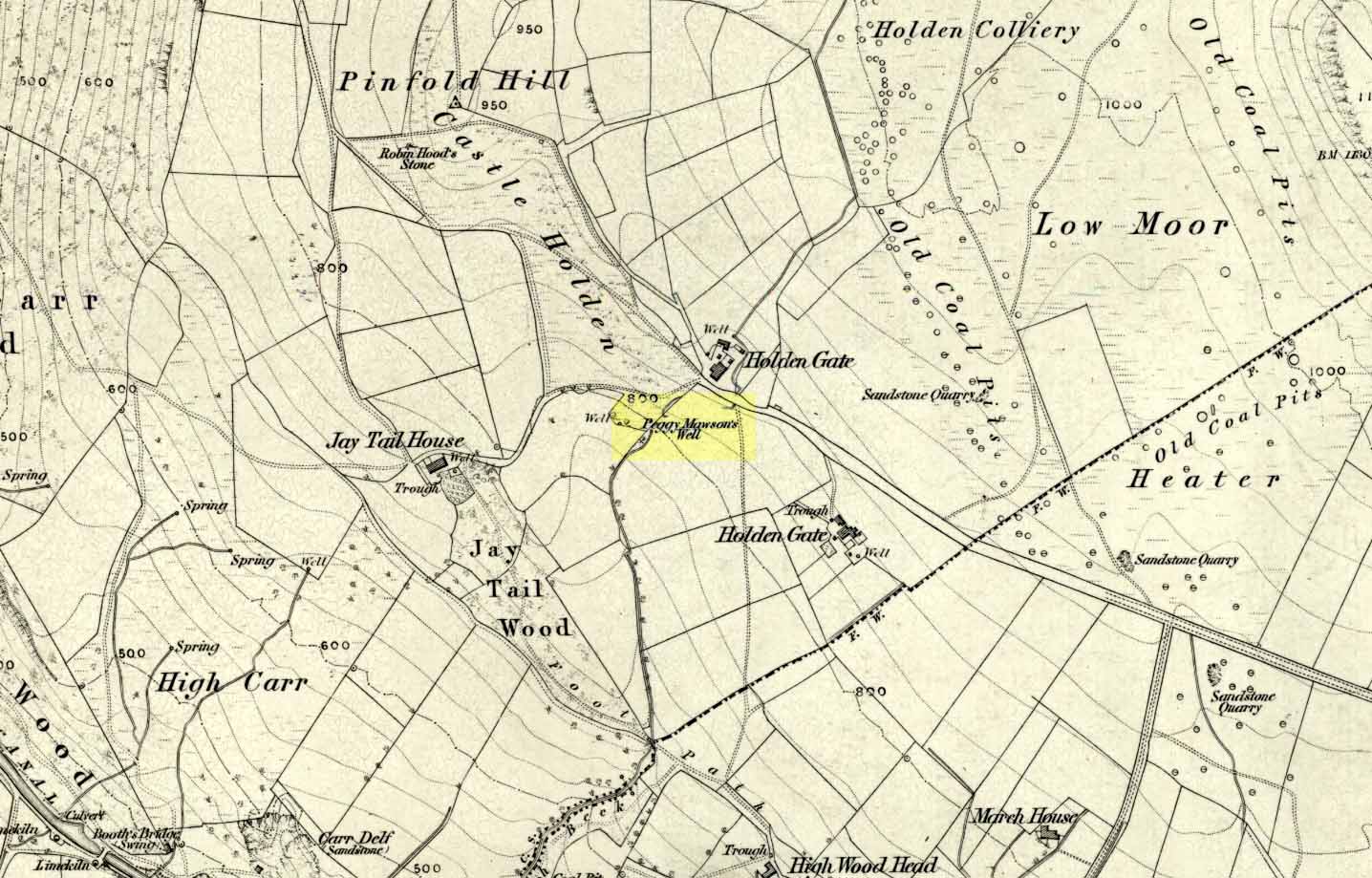
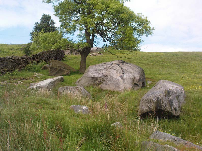
Dead easy! If you come from Silsden, take the Holden Road up onto the moor edge, all the way up the wooded hill. As you reach the top, keep your eyes peeled for the stone in the slope to your left. Otherwise, coming from Riddlesden, take the moor road upwards (to Silsden Road) as if you’re gonna visit Peggy Mawson’s Well, the Baldwin Stone or some of the Rivock carvings. Keep on the road to where you see the microwave tower on Pinfold Hill to your right. It’s just below it!
Archaeology & History
Robin Hood’s Stone from above
Flints have been found on the slopes above here, but records of this stone only go back — as far as I’ve found — to 1850 (this seems to typify records around the Keighley district, which only seems to record anything post-1500 AD). In mid-Victorian times, plans were afoot to use the rock for building material, but local people objected and so the stone kept its position overlooking the valley. There are a number of very defined ‘cups’ on the sloping face of the stone, but several (though not all) of these have all the likeness of the holes dug into the rock by climbers — though why climbers would even think to cut foot-holes into this easy rock beggars belief!
Folklore
One of several sharp well-defined ‘cups’ on the rock
Not too surprisingly, folklore tells that this stone was one of the places where our old hero Robin Hood sheltered, when being chased by god-knows-who in one of his many exploits. We’ve no way of proving this of course, but the sparse woodland remains above here also bear the hero’s name. What seems to be a more modern piece of industrial folklore alleges that this stone was actually put here by workers in the Victorian times! The boulder allegedly lived near Barden, Bolton Abbey, but was blocking construction work, so was uprooted and moved all the way to where it now sits! In bygone times the rock was a local meeting place – perhaps around Beltane, in line with Robin Hood festivities.
References:
Gray, Johnnie, Through Airedale from Goole to Malham, Elliot Stock: London 1891.
From Riddlesden, take the road up to the moorland and Rivock Edge. When you reach the top (Silsden Road), turn left. Go on for about 600 yards till you reach the lovely tree-hidden old cottages of Holden Gate, on your right. Stop — and walk down the footpath opposite from here. As the wall goes down, you’ll notice a stream in the next field to your left, emerging from a clump of large rocks. That’s it! (there’s a footpath in the next field from the roadside)
Archaeology & History
Shown on the first OS-map as ‘Peggy Mawson’s Well,’ little else seems to known of this place; though it obviously got its name after the local lady, Peggy Mawson. I can find no further information about this lady, nor why the site was named after her. Any help here would be hugely appreciated!
Peggy Mawson’s Well – now drained-off through pipes
Sadly the waters from beneath the rocks have been channeled into a couple of pipes and the well no longer runs. All that’s left is a small boggy region just in front of the boulders. You have to walk about 100 yards further down the field where the water emerges from a modern pipe. It doesn’t taste as nice as it originally did when coming straight from the ground, but it’s still quite drinkable (certainly beats any of the chlorinated stuff* that customers are forced to pay for, whether we want it or not – and most people don’t want it).
Folklore
This site has acquired modern folklore, but sadly no early traditions have been found. Whelan & Taylor (1989) thought that Peggy Well’s “dedication suggests a connection with St. Margaret,” which unfortunately isn’t the case. Several years later another writer, Val Shepherd (1994), spun the speculation even further, not checking the historical background to the site, and thought that “the well’s name may be derived from the water spirit, ‘Peg,’ who gave her name to other wells.” Sadly neither idea holds any sway.
References:
Shepherd, Val, Historic Wells in and Around Bradford, HOAP: Loughborough 1994.
Whelan, Edna & Taylor, Ian, Yorkshire Holy Wells and Sacred Springs, Northern Lights: Pocklington 1989.
* Anyone know about this: surely because the water companies chlorinate and add other undesirable toxins into our tap water, what we’re actually drinking is a very weak solution and not actually water. Isn’t that a trading standards violation?
Very close to the edge of the M9, this old water source is thankfully still visible, though not in its original state. At the bottom of the ridge, loosely enclosed in the grounds of St. Thomas Well House, we find that the original well has been submerged into the pond which covers it.
Folklore
I’ve not yet found the mythic origins behind the dedication to this site, though St. Thomas’ Day is the winter solstice on December 21, and his mythic status was that of didymus, or twin. In Yorkshire, folk customs surrounding this figure have been found to be inextricably intertwined with death rites, Robin Hood and shamanism! But this Stirlingshire site is as yet silent. The presence of numerous prehistoric burials very close by may have something to do with its dedication, as such sites would heighten the likelihood of there being ‘heathen’ practices close by, to which the said ‘St Thomas’—or one of his emissaries—could subdue with their christian figure. But that’s pure speculation on my part…
References:
Attwater, Donald, The Penguin Dictionary of Saints, Penguin: Harmondsworth 1965.
Morris, Ruth & Frank, Scottish Healing Wells, Alethea: Sandy 1982.
Fleming, J.S., Old Nooks of Stirling, Delineated and Described, Munro & Jamieson: Stirling 1898.
Royal Commission on the Ancient & Historical Monuments, Scotland, Stirlingshire – volume 2, HMSO: Edinburgh 1963.
From the village of Midgley, high above the A646 Halifax-to-Todmorden road, travel west along the moorland road until you reach the sharp-ish bend in the road, with steep wooded waterfall to your left. From here, across the road (roughly) there’s a track onto the moor. Go up this, keeping to the line of the straight walling uphill by the stream-side (instead of following the path up the quarries) all the way to the top. Here you’ll see the boundary stone of Churn Milk Joan. Take the footpath to its side for up onto the moor 250 yards or so, taking a right turn into the deeply cut footpath and walk along for several hundred yards, keeping your eyes to the north (right). You’ll see the rocky cairn of Miller’s Grave not far away in the heather, near to the large rounded boulder known as Robin Hood’s Pennystone.
Archaeology & History
Ascribed by some as neolithic, and others as Bronze Age (the more probable), here is a curious archaeological relic: curious, inasmuch as it’s received very little attention from archaeologists. It’s quite a large monument — and perhaps the fact that it has always seemed to be in isolation from other prehistoric remains has held it back a little. But recent ventures here have brought about the discovery of more cairns (though singular small ones), neolithic walling, hut circles and other prehistoric remains that have never previously been reported.
Miller’s Grave, Midgley Moor (in VERY heavy rain!)Central stone aligning north to Nab End
It’s a decent site aswell. Mainly consisting of the usual mass of smaller stones piled up and around one main point; in the middle of this ‘tomb’ is a large split glacial erratic boulder, which may have been the original focus of the builders. Some may even ascribe a coupla cup-markings on this ‘ere central rock form — but they’d be pushing it a bit! This large central feature aligns to the high peak of Nab Hill several miles north, above Oxenhope. Whether this feature was of any significance in the cairn’s construction is debatable (though as north represents death in pre-christian peasant lore, this ingredient has to be noted).
Profile shot – looking NELooking SE, with small cairn in foreground
The cairn is a goodly size: some 4 feet tall and about 50 foot across at its greatest diameter. Some of the stones near the centre of the stones have been put there in more recent years. In previous centuries, treasure-seekers came here in the hope that they’d uncover gold or other trinkets and stripped off much of the original cover, moving many rocks to the edges. Others were also stolen from here to make some of the grouse-butts, not far from away. In a foray to the site on 5.9.10. we were lucky to find the heather had been burnt back and found, some ten yards to the north and to the southwest, the remains of small, outlying singular cairns (though these need excavating to ascertain their precise nature).
Calderdale Council’s archaeology notes on Miller’s Grave tell it to be “situated on the summit of Midgley Moor”, which is quite wrong. The summit of the moor is some distance west of here, near where an old standing stone called the Greenwood B stone (75 yards south of the Greenwood Stone) and the much denuded remains of other prehistoric sites could once be found — though I’m not sure that they, nor the regional archaeologist for Upper Calderdale has ever been aware of them.
Folklore
In F.A. Leyland’s (c.1869) extensive commentary to Watson’s History of Halifax (1775), he relates a fascinating tale which seems to account for the name of this old tomb:
“About ninety years ago,” he wrote, “that is, towards the end of the eighteenth century – one Lee, a miller, committed suicide in Mayroyd Mill near Hebden Bridge. The jury at the inquest held on the occasion returned a verdict of felo-de-se, and the body was buried at Four Lane Ends, the Rough, in Midgley. The fact, however, of the body of one who had laid violent hands upon himself, lying in unconsecrated ground at a point where the highways met, and at a spot which the inhabitants passed early and late, oppressed the people of the neighbourhood with an irresistible dread. Persons going to market and passing from village to village, feared and avoided the unhallowed spot, until the feeling increased to one of insupportable terror; and, in the night time, a multitude collected with torches to disinter the body. This was speedily effected and violence was even offered to the dead. A man named Mark Sutcliffe, and others, who attempted to prevent the exhumation, were stoned* by the mob, and the body was hurried to the cairn on Midgley Moor, where it was hastily interred. Here however, it was not allowed to rest; the isolation of the body, though buried in a lonely spot, was yet apart from the common cemetery where the dead lie together in their special domain; and this invested the surrounding district with a superstitious awe difficult to describe. The body was still too near the haunts of the living; and, to the perturbed imagination of the inhabitants, the unquiet ghost of the suicide constantly brooded over the hills. As this was not to be endured, the body was at last removed from the cairn, and finally buried in the churchyard of St. Thomas a’ Beckett’s, Heptonstall. Although the interment of Lee, at the cairn, has conferred upon the spot the name of the Miller’s Grave, it cannot be doubted that the large quantity of heavy stones which we find heaped together at this place…was piled up in distant times…”
Modern pagan folklore ascribes the name of this site to relate to Much, the Miller’s Son: acquaintance of the legendary Robin Hood, whose ‘Penny Stone’ boulder is just 100 yards west of here.
From Durness take the road east for a couple of miles till you see the signpost which takes you on the left-hand side of the road, down to the coast. You can’t miss it!
Archaeology & History
Findings here allege to take the history of the place into the mesolithic period, but we don’t know this for sure. An excavation here by a Mr Donald Macdonald of Sangobeg in 1904 uncovered the presence of several small bone pins, which seem consistent with Mesolithic finds elsewhere. When archaeo-excavations were done here in 1982, human remains going back to at least Iron Age were found in the simple deposit of many shells. A further analysis by the Glasgow Archaeology Unit in 1996 was prevented of some excavation by (get this!) those screwy Health & Safety regulations. Here’s a definite case for an independent group to undertake work here, as we could ignore such preventative measures (and if we drown it’s our fault!). Smoo Cave’s primary function is pretty obvious: it would have been used for both shelter and ritual.
Folklore
The folklore here tells of magick and occultism and possible remnants of rites of passage lore. For herein, many centuries ago, a powerful land-owner called Lord Reay — reputed as a master in the black arts — battled with the devil in the Smoo Cave.
The devil was keeping watch on Lord Reay following a previous dispute between the two of them, and espied him as he entered the cave. As Alexander Polson told it, the cave
“consists of three caverns, one within the other. Lord Reay had got as far as the second, and his dog, which had gone on in advance, returned howling and hairless. By this, Lord Reay knew that Satan was there before him, and bravely waited the attack, which was soon made, and his lordship fought lustily. Happily at the opportune moment a cock crew. This frightened the devil and his attendant witches, but Lord Reay stood between them and the exit. In their fright they blew holes through the roof of the cave, and this is the origin of the two openings through which the Smoo burns fall.”
Pitch black cave; protective spirit animal; encountering one’s psychological nemesis; unconscious battles with Underworld forces; rebirth of the sun at cock-crowing time; the conquering of the dark forces and renewal of Lord Reay. These are typical hallmarks probably signifying folk-remnants of shamanism and rites of passage, for which this cave may once have been used.
References:
Polson, Alexander, Scottish Witchcraft Lore, W. Alexander: Inverness 1932.
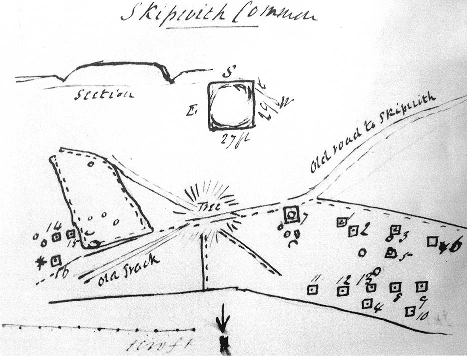
Travelling up (north) the A19, just as you get to Riccal village, there’s a small road to your right: take this! A mile along there’s a parking place just where the track veers into the woods. That’s where you’re heading. The remains of the tombs hereabouts can be hard to discern – but if your lucky you’ll either meet a local, or the virtue of patience will bring these overgrown tombs into focus! There are other tumuli a few hundred yards east and north of here aswell. If you wanna get a clear picture of them all, a full day would be a good bet!
Archaeology & History
Not to be confused with the other Danes Hills tombs a couple of miles northeast of here (as done on some other sites), the early Victorian geologist and explorer John Phillips (1853) was one of several early writers who described what, today, are known to be Iron Age tombs, scattered about a short distance east of Riccall village, saying:
“On Skipwith Common are many tumuli, old banks, and the slightly-marked foundations of ancient (turf or log?) houses or wigwams. These, by some error of tradition, are called ‘Danes’ Hills/ but, on opening the tumuli, no confirmation of so modern a date appeared. The tumuli are set in square fosses; the sides of the fossae range north and south and east and west (true). Similar facts appear in connexion with the tumuli on Thorganby Common adjacent. Burnt ashes and bones occur in the mounds; facts which suffice to overthrow the supposition of these hills being funeral heaps of the Danes of the llth century, for they then buried their dead. No instruments of metal, bone, or stone, or pottery were found.”
There were dozens of tombs that could be seen here in the past, but today many have been destroyed or are hidden by the cover of trees. A sketch-map (above) showing the rough location of many of the graves was made by the Yorkshire Antiquarian Club after a visit here in 1849 (Proctor 1855), who opened several of the barrows. Archaeologist Ian Stead (1961; 1979) defined these remains as being of the famous La Tene burials — though I’m unsure as to whether any of the tombs here had the great horse-chariots found in them, as found in the more famous Danes Graves tombs close to Driffield.
Folklore
The name of these small hills acquired their Danish title via a mix of real history and folklore. History tells of the old Danish King Harald Hardrada, who moored his fleet of ships a few miles away from here before going into battle against the armies of Northumbria and Mercia. “Dane’s Hill,” said Bogg (c.1895), “still marks the spot where the fight took place.” As John Burton (1758) told us:
“Ever since the aforesaid battle, it is by tradition to this day said, that the Danes were permitted to encamp here till they had buried their dead, and their ships at Riccal should be ready for their re-embarking for Norway.”
Local folk used to tell of the tradition of the local swamp — called Riccal Towdyke — being choked with the bodies of many slain in the battle hereabouts. Many pieces of red cloth were found all around in the neighbourhood of these tombs. However, despite this mix of fact and folklore, the tumuli were see marked on the modern OS-maps have been found to be Iron Age in origin.
…to be continued…
References:
Bogg, Edmund, From Eden Vale to the Plains of York, James Miles: Leeds n.d.
Burton, John, Monasticon Eboracense, N. Nickson: York 1758.
Elgee, F. & H.W., The Archaeology of Yorkshire, Methuen: London 1933.
Morrell, W. Wilberforce, The History and Antiquities of Selby, W.B. Bellerby: Selby 1867.
Phillips, John, The Rivers, Mountains and Sea-Coast of Yorkshire, John Murray: London 1853.
Proctor, W., ‘Report of the Proceedings of the Yorkshire Antiquarian Club, in the Excavation of Barrows from the Year 1849,’ in Proceedings of the Yorkshire Philosophical Society, 1855.
Stead, I.M., ‘A Distinctive Form of La Tene Barrow in Eastern Yorkshire,’ in Antiquaries Journal, volume 41, 1961.
Stead, I.M., The Arras Culture, Yorkshire Philosophical Society: York 1979.
Standing Stone (destroyed?): OS Grid Reference – SE 1765 5032
Archaeology & History
Eric Cowling (1946) described this lost or destroyed stone as “a squat standing stone at junction of the Askwith bridge-path with the Otley-Timble highway, saying how it gave its name to Stoop Hill, “which it surmounts.” But in several ambles here in search of this old stone, we’ve yet to locate it; though we did find the Stoup Hill cup-marking and possible neighbour on the southern edge of the hilltop.
Folklore
In days of olde, the ‘Old Man’ was the fabled companion of the legendary ‘Old Woman,’ or great cailleach (the christian cult stupidly, somehow, turned this mythic figure into their ‘devil’ – to which it has no relationship whatsoever). Although no specific folktale remains here, the name of this lost stone tells that it had some mythic tale underscoring it; perhaps simply that it marked the burial of some forgotten chief or elder.
In terms of getting here, follow the directions given by H.C. Collins (1946), who reached here from Healey, north of Rochdale. “Once past Lousy Hillock the track continues in front of Brown House Reservoir… The track climbs Faffelty Brow under the lea of Man Stone Edge on the left”, above the Rossendale Way footpath. You can of course come straight up from Whitworth, heading up the eastern hill over Lobden golf course. The site’s to the northeast edge of the course.
Folklore
I first read of this a couple of decades back, in Jessica Lofthouse’s (1976) folklore book, but her pronunciation of the site — which I sought and sought, without success — made finding the place really troublesome. Thankfully, the local guidebook of Harold Collins (1946) has brought this site into focus once more and, it would seem, the probable site of prehistoric archaeological remains. But until we get over here and have a good look round, that aspect of the Man Stone will have to await assessment.
Collins (1946) described the “huge stone on the moortop on the left of the track” he’d been walking along, telling how “according to legend it bears the imprint of a human hand and was thrown (here) from Blackstone Edge by Robin Hood.”
Lofthouse (1976) told similarly when she was describing the folklore of Robin Hood’s Bed, about six miles east of here, by the Yorkshire-Lancashire border, saying,
“Robin was a mighty hurler as well as a bowman without peer. To while away waiting time in the Bed he took a large boulder from the giant’s overspill at hand, threw it and watched its course. Six miles away on Monstone Edge that boulder dropped, a feat amazing , and has been called Robin Hood’s Quoit ever after!”
But the “quoit”, said Lofthouse, was there centuries before any legendary Robin Hood — as it would have been. As far as I can find though, no such prehistoric relic ‘officially’ exists upon this hill. But as those of us who’ve been into seeking these old sites know, that doesn’t necessarily mean a thing. Henry Fishwick’s (1889) notes about the markings on the rock — “and certain impressions on its surface are said to be the marks of the fingers and thumb of the thrower” —may also prove fruitful.
Adding fuel to an authentic animistic history is the existence, once, of the Old Man’s consort: his Old Woman, or Cailleach, whose well and other landscape features existed to the north. Much of our peasant history is clearly just beneath the surface in this unexplored archaeomythic region…
References:
Collins, H.C., Rambles round Rochdale, Thomas Yates: Rochdale 1946.
Fishwick, Henry, History of the Parish of Rochdale, James Clegg: London 1889.
Lofthouse, Jessica, North Country Folklore, Robert Hale: London 1976.
The local historian, H.B. McCall (1910) described this ‘Saint Lambert’s fountain’, as it was first called, in his fine work on local churches, telling of its early description in the 12th century, saying:
“This is a very early mention of St. Lambert, the patron saint of the church and parish (of Burneston). The fountain or well was probably situated in what is now the new portion of the churchyard, and the rivulet is now enclosed as a drain. The name of the wapentake of Halikeld is said to be derived from St. Lambert’s Well at Burneston.”
I can find little else about these old healing waters. Anyone got anymore info?
References:
McCall, H.B., Richmondshire Churches, Elliott Stock: London 1910.