Pennythorn Hill, Baildon Moor, West Yorkshire

Tumulus (destroyed):  OS Grid Reference – SE 13922 40984

Archaeology & History

Pennythorn Hill urn
Site highlighted on 1909 OS-map
Site shown on 1909 OS-map

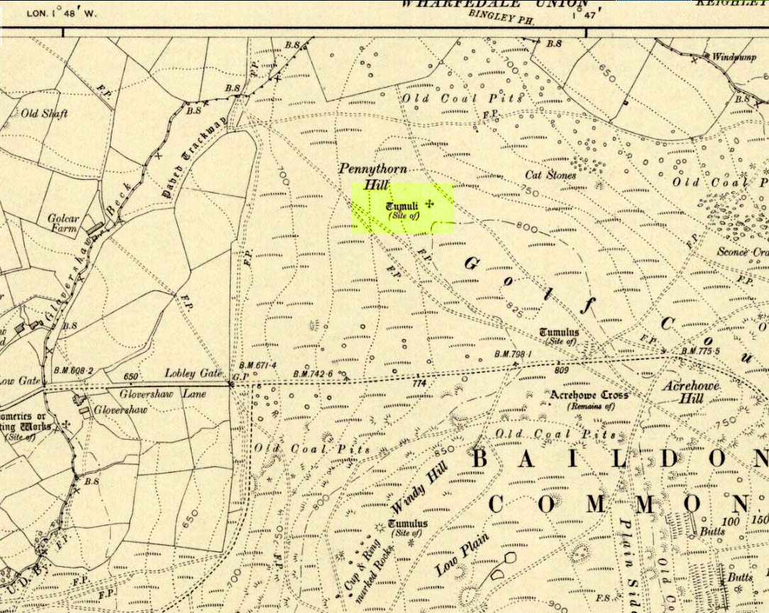
Highlighted on the 1909 OS-map of the area, on the top of the hill a short distance from the roadside, about 250 yards northwest of the Acrehowe Hill site (now at the edge of the golf course) could once  be seen another prehistoric burial mound.  The rediscovery of this tumulus was first announced briefly in the January 1905 edition of the Bradford Scientific Journal (issue no.3).  A few months later the local writer and historian William Preston (1905) wrote a more detailed article on the site, telling the following information:

“A discovery of considerable interest to local archaeologists was made early in December, 1904, on the summit of the spur of moorland on the northwest of Baildon Moor, known as Pennythorn Hill.

“A workman engaged in removing stones from an extension of the golf course, unearthed an ancient cinerary urn containing calcined human bones, a flake of flint which may have served the purpose of an arrow point, a bronze instrument, and a perforated piece of bone, unfortunately broken during calcination.  An examination of the site of the discovery revealed the remains of a tumulus, the upper part at some time removed, with a diameter as near as it was possible to tell, of about fifteen feet.  In point of construction it differed little from others which are to be found in the locality.  The vessel had been placed in an inverted position over the calcined bones, in a hole made in the sandy subsoil.  There was no indication of the urn having rested in a cist.

“The earth beneath the urn bore no evidences of fire, and it is likely that the funeral pyre on which the corpse was reduced to ashes was not erected on the spot.  It may be assumed from the association of the weapons named that the bones are those of a male person.

“The height of the urn is twelve and a half inches, it is eight and a quarter inches in diameter, and taper in the lowest third of its height to a base of about three inches in diameter.  In the course of its excavation it was broken by the workmen, but it has been excellently restored in the laboratory of the Hull Museum…

“The urn belongs to the early British type and its date is, probably, well before the Roman invasion of the island.  The general outline of the urn is very similar to that of some urns found by Canon Greenwell in the course of his exploration of the barrows of the north of England… The surface of the urn is divided into three zones.  The upper part of the vessel consists of a raised border, about four inches wide, decorated with horizontal and vertical lines alternately arranged, and produced by pressing a twisted thong up0n the clay of which it was composed… Beneath the border and upon the central part of the body, a different form of decoration has been carried out.  A zig-zag line scratched in the clay has been carried around the body, forming a number of triangular compartments, which were filled in with diagonal lines, giving he appearance of a herring-bone pattern.  The counterpart this design does not appear on any of the urns figured by Canon Greenwell in his records of digging in British barrows.”

References:

  1. Greenwell, William, British Barrows, Clarendon Press: Oxford 1877.
  2. Preston, William E., “The Discovery of a Cinerary Urn on Baildon Moor,” in Bradford Scientific Journal, no.4, April 1905.
  3. Wardell, James, Historical Notes of Ilkley, Rombald’s Moor, Baildon Common, and other Matters of the British and Roman Periods, Joseph Dodgson: Leeds 1869. (2nd edition 1881)

© Paul Bennett, The Northern Antiquarian 


Wytchley Warren, Edith Weston, Rutland

Tumulus (destroyed):  OS Grid Reference – SK 961 052

Also Known as:

  1. Wicheley Warren

Archaeology & History

This tomb and, it would seem, another 200 yards away, have long since been smashed up.  The only decent reference to the site comes from Reginald Haines’ address to the Society of Antiquaries in January, 1903, where he told:

“In a quarry worked for freestone on Major Brathwaite’s land…was found in 1900 a skeleton, probably neolithic.  The body was in a crouching position, with ‘the knees tucked under the chin,’ at a depth of about 3 feet.  Unfortunately, no one interested in such things was at hand, and the remains were incontinently thrown aside and (are) presently buried under a mass of rubbish from the tunnels which were being worked for stone.  Mr V.B. Crowther-Beynon was only able to recover a few teeth, though he seems to have found a few fragments of animal bones and bits of pottery at or near the spot.

“In December 1901, at a point about 200 yards from the last, where a fresh excavation was being made, a second interment was found.  In this case the soil containing the remains came down in one block, and a few broken fragments of bone came to light, with a lower jaw.  The jaw is now in Mr V.B. Crowther-Beyson’s possession, who communicated with Lord Avebury on the subject, sending the jaw, and received the following reply:

“‘to judge from your description (i.e., of the interment) it is certainly probable that the interment you mention belonged to the stone (neolithic) age.  This, however, in the absence of weapons or implements, cannot be put higher than a probability.  I think that lower jaws like very this might be found among our existing people, though I fear with hardly such good teeth.  Their soundness and the way they were worn point strongly to a great antiquity.’

“Near the second interment occurred little patches of burnt soil of a conspicuously red colour.  These may have been the sites of hearths.”

Mr Haines makes a final note about the scarcity of prehistoric remains found hereby, saying that “the only other relics of the stone age that claim notice here are an arrow-head of flint, picked up in a field near Market Overton in November 1990, by Mr Wing” — which is quite a distance away!

References:

  1. Haines,  “Prehistoric Graves at Wicheley Warren,” in Proceedings of the Society of Antiquaries, volume 19, no.2, 1903.

© Paul Bennett, The Northern Antiquarian


Slade Carving (02), Blubberhouses Moor, North Yorkshire

Cup-Marked Stone:  OS Grid Reference – SE 1411 5431

Also Known as:

  1. Owl Stone
  2. Sunset Stone

Getting Here

Cup-and-rings, looking NE

Same directions as the Slade 01 carving.  But once you reach the upstanding stone cairn on the rocky hill, walk 220 yards (less than 200m) WSW and look around.  You’re damn close!  If you find the large cup-marked Slade 03 carving,  walk back east about 10-20 yards and you can’t really miss it!

Archaeology & History

This is just one of at least seven previously undiscovered carvings on this section of moorland – and it’s worth looking for!  The two other names we gave it — ‘owl’ and ‘sunset’ — come from the very notable design: owl thanks to it having the appearance of large owl-like eyes, and sunset as the two cup-and-rings are etched on the western edge of the rock and, when we found it yesterday, the sun was setting (albeit to the NW) and the image prompted talks of setting suns, the land of the Dead and other such worldwide indigenous religious myths (Harvey 2000) — for without recourse to such ingredients, these carvings are vacuous archaeocentric museum pieces and nothing more.  And this carving at least deserves much more than mere cataloguing!  The internationally renowned archaeologist, O.G.S. Crawford (1957) would have entered this carving into his ‘eye’ and ‘owl’ motif, representative of goddesses or spirit-forms, as would Gimbutas. (1989)

…and from above

But this carving is archetypal, as we can see, though would appear to have no other etched features on the stone’s surface.  It is very close (if not within) the prehistoric graveyard that is plainly evident 30-40 yards south in the burnt heather and would very likely have had some mythic relationship with the dead (a symbiosis we have found in many cup-and-rings).  We plan further ventures here in the coming weeks in the hope that we can unearth other prehistoric remains.

References:

  1. Crawford, O.G.S., The Eye Goddess, Phoenix House: London 1957.
  2. Gimbutas, Marija, The Language of the Goddess, Harper Collins: New York 1989.
  3. Harvey, Graham (ed.), Indigenous Religions, Cassell: London 2000.

© Paul Bennett, The Northern Antiquarian


Slade Carving (01), Blubberhouses Moor, North Yorkshire

Cup-Marked Stone:  OS Grid Reference – SE 1421 5440

Getting Here

Simple cup-marked stone

From Blubberhouses church by the crossroads, walk up the slope (south) as if you’re going to Askwith, for 100 yards or so, taking the track and footpath past the Manor House and onto the moor.  Once you hit the moorland proper, take the footpath that bears left going down into heather and keep going till you hit the dead straight Roman Road path running west onto Blubberhouses Moor.  Go on here for nearly a mile until you hit the stream and nearby Eagle Stone boulder.  Walk upstream from here, on its eastern (right-hand) side for 100 yards, then walk up onto the level moor, scattered with rushes.  Keep up here, heading towards the upright cairn open the skyline to the north.  Once here, walk 80 yards (73m) WNW and you’ll note a number of flat stones embedded in the heather around you.  You’re damn close!

Archaeology & History

Off-path and takes some finding and will all-but disappear when the heather grows back, so this one’s probably only for the purists amongst you.  But I like it anyway!  This is one of at least seven newly-discovered cup-marked stones hereby, including the nearby ‘Owl Stone’ with it’s big eyes!  There are just two cup-marks on the flat surface: one an archetypal large cup 3 inches across and a half-inch deep; the other, a small faint cup less than 2 inches wide and very shallow which is easily missed if you pay little attention.  On the photo here, the fainter cup is slightly above right of the centre.  The carving appears to be on the far eastern edges of the Slade Cairnfield.  Other undiscovered remains are likely to be found here.

© Paul Bennett, The Northern Antiquarian


Lippersley Pike, Denton Moor, North Yorkshire

Cairn:  OS Grid Reference – SE 14335 52478

Getting Here

Follow the directions to reach the Lippersley Pike cup-marked stone, then keep walking westwards, but go up the slope immediately on your right (north) and walk upwards along the path to the notable stone structure at the top-end of the ridge a coupla hundred yards ahead.  Once there, you’re standing on it!

Archaeology & History

Lippersley Pike & shooter’s butt

A little known site with some excellent 360° views all round, reaching as far west as Pendle Hill, north past Simon’s Seat, and east onto the far reaches of the North York Moors.  The landscape here is truly superb!  And humans have been here since, it would seem, mesolithic periods at least, if Cowling’s finds are owt to go by! For although he described the much denuded tomb that we can still see under the herbage and recently-built shelter, there was also, “on the northern slope…a small occupation immediately below the summit on the northern side.”  We found remains of it on our visit here the other day.  But of the tomb itself — which Mr Cowling thought was neolithic in age — he wrote:

“The highest point of Lippersley Pike, on Denton Moor, is crowned by a stone cairn 1083 feet above sea level, and overlooks, on the northern side, a small site which appears to have been occupied by the ‘Broad Blade’ people, for there occur several pieces of patinated flint, along with scrapers and worked blades.”

Aerial view of Lippersley Pike

Cowling then describes a number of flints and other prehistoric working utensils that he found all round here.  The remains of the cairn measure some 25 feet east-west and 23 feet north-south.  There has been no excavation here, although the fella’s who dug out much of the stone to build the shooter’s butt on its top may have found summat, but have kept it quiet!

The cairn is an ancient marker along the boundary line marking the townships of Denton and Great Timble and was visited in perambulation walks in previous centuries.  Grainge (1871) describes the extensive perambulation in his Knaresborough Forest work.  ‘Lippersley’ itself first appears in records from 1576, although A.H. Smith (1963:5) does not suggest an etymology.  The place is worth visiting as a good starting point to explore the other little-known prehistoric remains on these moors, including the Crow Well settlement, the Heligar Pike tomb, etc, etc.

References:

  1. Cowling, E.T., Rombald’s Way: A Prehistory of Mid-Wharfedale, William Walker: Otley 1946.
  2. Grainge, William, The History and Topography of Harrogate and the Forest of Knaresborough, John Russell Smith: London 1871.
  3. Grainge, William, The History and Topography of the Townships of Little Timble, Great Timble and the Hamlet of Snowden, William Walker: Otley 1895.
  4. Smith, A.H., The Place-Names of the West Riding of Yorkshire – volume 5, Cambridge University Press 1963.

© Paul Bennett, The Northern Antiquarian


Fairy Holes, Whitewell, Lancashire

Legendary Cave:  OS Grid Reference – SD 6553 4677

Getting Here

Fairy Holes site

John Dixon took a bunch of us on a pleasant amble here via the Fair Oak Circle site.  From Fair Oak, go round the back of the farm and past the small cluster of hidden cottages, then bear right down the dirt-track and up the slope, then cross the field in front of you, going over the stile, following the footpath round the eastern edge of the slightly limestone New Laund Hill, and down again, thru the gate.  From here, head diagonally across the field 150 yards towards the fencing at the woodland edge.  Over the fence, into the trees, head halfway down the steep-ish slope and keep your eyes peeled for the rocky outcrop nearly halfway down.  Alternatively, an easier way here is apparently from the Inn at Whitewell.  Go across the river via the stepping stones (or wade!) and follow the footpath uphill towards a farm, where you’ll find a large steel gate on the left that leads into the woods.  Here there are 2 paths: follow the higher of the two until it starts bearing to the right.  Once here, look up the hill to the right you’ll see the rock outcrop.  The caves are there!

Archaeology & History

Smaller Fairy Hole

There are at least 3 caves here, close to each other along the edge of the small footpath a few yards apart.  The small rounded entrance of the northernmost one (photo, right) is reported by English Heritage to have had no human remains found therein, but further investigation is required here.  The main cave however is where intriguing prehistoric finds were located.  It appears that the entrance was deliberately built-up and blocked by stone walling a few yards inwards, giving the remains found therein a state of protection and sanctity.  Writer and historian John Dixon (2004) tells what was in the cave:

“In 1946, an excavation was carried out on the site by the archaeologist Reginald C. Musson.  In front of the larger cave is a flat platform on which evidence of Bronze Age daily life was found.  This included animal bones, a pebble pounder (used to extract marrow from bones) and shards of a food vessel.

“All that survived of this tripartite collared urn was a large rim-collar shard, two fragments displaying neck/shoulder/body elements and five smaller pieces, probably from the base of the body.  This is the only collared urn to have been found in a cave in Lancashire.  Its tripartite Pennine form assigns it to an early Bronze Age date.”

The main Fairy Hole
Plan of cave chamber (after J.Dixon 2004)

The artificial walled entrance may not merely have been an ingredient giving sanctity to the place, but this could well have been a site for ritual shamanic practices, including prolonged rites of passage and death rituals (authentic ones, not the modern pagan nonsense).  The ‘ritual death’ elements are highly probable here for, as John Michell (1975) told, caverns and crevasses are “most responsive to the necromancer’s invocation”.  It’s geomancy, spirit association and the archaeological finds therein are strongly suggestive of this usage. (Eliade 1989, 1995; Maringer 1960, etc)  Bearing this in mind, it is of some concern regarding the individual who thought it wise to spray-paint his name against the wall of the cave entrance (see photo); for many are those even in these days of shallow minds who fall prey to the car-crashes and creeping madness brought upon themselves by desecrating ancestral sites of ritual magick.  It would be intriguing to keep a prolonged eye on the ‘Forsh’ who painted his ego in this cave of dead spirits…

Folklore

Not surprisingly, the little people hold legend here.  Jessica Lofthouse (1946) found tales of these ancient peoples in several places close by, but at the Fairy Caves specifically,

“everyone knew that these little caves in the limestone at Whitewell were the homes of the little folk.”

…And in relation to the ingredient mentioned above, about ritual use of the cave in ancient times: are there any serious ritual magickians who’ve spent time working in this cave, overnight or longer, and who can let us know of their encounters here? (long shot, I know – but it’s worth asking, considering the probable use of the place)  Or perhaps spontaneous encounters of other people here…

References:

  1. Dixon, John, The Forest of Bowland, Aussteiger Publications: Clitheroe 2004.
  2. Eliade, Mircea, Shamanism, Arkana: London 1989.
  3. Eliade, Mircea, Rites and Symbols of Initiation, Spring Publications: Woodstock 1995.
  4. Lofthouse, Jessica, Three Rivers, Robert Hale: London 1946.
  5. Maringer, Johannes, The Gods of Prehistoric Man, Weidenfeld & Nicolson: London 1960.
  6. Michell, John, The Earth Spirit: Its Ways, Shrines and Mysteries, Thames & Hudson: London 1975.

© Paul Bennett & John Dixon, The Northern Antiquarian


Big Rings Henge, Dorchester, Oxfordshire

Henge (destroyed):  OS Grid Reference – SU 572 953

Archaeology & History

Very close to the once impressive Dorchester Cursus, this double-ringed prehistoric monument can no longer be seen thanks to the self-righteous arrogance of modern industrialists who care little for the ancestral monuments of the British people, destroying all traces of the site — an activity which, in this case, astonishingly started in more ancient times, as Jean Cook (1985) told: “The banks and the ditches had been levelled through agricultural activity, possibly in the Iron Age”!

Big Rings ground-plan
1938 photo of the Big Rings, by Major George Allen

The destruction of this environment continues to this day, destroying many important archaeological remains with little care.  Thankfully we we’ve got a good account of the site due to the archaeological excavations of R.J.C. Atkinson (1951) and his team in the late-1940s, from whom Cook and just about everyone else gets most of their data regarding the site.

The Big Rings Henge was probably built sometime in the middle of the second millenium BC.  It was an important prehistoric ritual site and, most likely, had some relevance to the adjacent cursus monument.  A number of important mortuary and ritual sites were also built close to the site over a period of nearly two thousand years, showing the importance this landscape had to our ancestors.

Jean Cook (1985) described the Big Rings henge as follows:

“The ditches, of which there were two, had opposed entrances on the NNW and SSE.  They were about 7.6m wide and 1.8m deep with flat bottoms.  Originally there seems to have been a broad low bank on the inner side of each ditch.  The southern entrance incorporated an existing monument, consisting of a ring ditch which enclosed a large four-post setting and contained a cremation and a stone axe.  Just outside the north entrance was a round barrow, containing a central oval burial pit which produced a crouched inhumation, together with a well-preserved beaker, two small copper or bronze knives and a rectangular wrist-guard of greenstone.  The Big Rings ditches themselves contained pottery belonging to the middle or late Beaker period.  Although the area within the ditches was trenched, there was no evidence of internal timber structures.”

References:

  1. Atkinson, R.J.C., “The Henge Monuments of Great Britain,” in Atkinson, Piggott & Sandars’ Excavations at Dorchester, Oxon (Department of Antiquities: Oxford 1951).
  2. Atkinson, R.J.C., Piggott, C.M. & Sandars, N.K., Excavations at Dorchester, Oxon, Department of Antiquities: Oxford 1951.
  3. Cook, Jean, “The Earliest Evidence,” in Dorchester through the Ages, Oxford University 1985.
  4. Harding, A.F., Henge Monuments and Related Sites of Great Britain, BAR 175: Oxford 1987.
  5. Harding, Jan, The Henge Monuments of the British Isles, Tempus: Stroud 2003.
  6. Wainwright, Geoffrey J., The Henge Monuments: Ceremony and Society in Prehistoric Britain, Thames & Hudson: London 1989.

© Paul Bennett, The Northern Antiquarian


Boatbridge Quarry, Thankerton, Lanarkshire

Cists (destroyed):  OS Grid Reference – NS 981 376

Also Known as:

  1. Tinto Quarry

Archaeology & History

The sites that were once here have long since been destroyed as a result of quarrying operations.  But thankfully this place was given a quick appraisal by those renowned Scottish archaeologists, Anna Ritchie and D.V. Clarke, before final destruction.  They recorded the site in an early edition of Discovery & Excavation in Scotland:

“Two short cists were discovered in November, 1970, during the removal of a long low gravel ridge protruding into the flood plain of the River Clyde.  The two cists were both aligned NE-SW and were 14m apart.  Both employed identical construction techniques.  The side slabs overlapped both end slabs and the N end slab was shorter than the other three slabs, necessitating a building-up of the floor by some 30cm.  Both appear to have had a double layer of capstones although this is uncertain in one case.  The cists contained and adult and child without grave goods on a gravel floor in one, and an adult with a beaker on a ‘crazy-paving’ floor in the other.”

Crazy-paving in prehistoric times sounds good!  The Scots got there first!

References:

  1. Clarke, D.V. & Ritchie, Anna, “Boatbridge Quarry: Short Cists,” in Discovery & Excavation in Scotland, 1971.

© Ian Carr, The Northern Antiquarian 


Bleara Lowe, Earby, Lancashire

Tumulus:  OS Grid Reference – SD 92663 45387

Getting Here

Bleara Lowe mound, looking NW

There’s no footpath to this site, but we came to it via the car park on Coolham Lane on the southeast side of Earby.  Walking uphill, we got over the wooden stile on the moorside and walked up the side of the walling, all the way upwards till we reached the top of the moor.  You’ll pass the large Bleara Moor tumulus just by the walling, then head towards the rounded hillock on the top of the moor a coupla hundred yards away.  Y’ can’t really miss it!

Archaeology & History

As with many sites in this area, very little has been said of this usually overgrown Bronze Age burial mound.  Although no known recorded excavation of the tomb has ever been done, someone dug into the top of the mound in the 1960s, but we have no record of any finds.  The tomb stands on the local boundary line between Earby and Lothersdale to the east and was known as ‘Bleara Haugh’ in the 1819 Enclosure Act.  But little else has ever been said of it.

Bleara Lowe
OS-map of site

When we visited the place a few months ago, we were fortunate in that the heather had been burnt back, so allowing a much better view of the site than normally afforded when it’s covered in heather.  The rounded mound was between 4 and 5 feet high and measured approximately 20 yards across.  The pit which had been dug into the top of the mound was still visible, though much overgrown.  The view from the tomb itself was very impressive — which would have been of some importance in the construction of the place.  The Pastscape website describes Bleara Lowe as:

“A slightly oval mound of peat and heather-covered stones up to 1.4m high with max dimensions of 21m E-W x 19m N-S. There is a rectangular hollow 3m x 1.5m x 0.4m deep on the cairn’s summit.”

Another larger tumulus or overgrown cairn can be found over 200 yards west of here; plus a number of small singular prehistoric cairns have been located further down the western slope of the moor, known as the Bleara Moor Cairnfield.  None of these sites have ever been excavated.

© Paul Bennett, The Northern Antiquarian


Hades Hill, Whitworth, Lancashire

Cairn:  OS Grid Reference – SD 909 202

Getting Here

The Hades hill cairn/barrow is located high on the moors some 3 miles north-east of Whitworth and the smaller village of Facit, near Rochdale. Its exact location is close to a footpath halfway between Hades hill and Rough hill, though it is not mentioned on modern OS maps. It is quite difficult to get to so be ready for a long hard walk.

Archaeology & History

This small, low barrow or cairn — a couple of miles north of the little-known Man Stone — measures 15 metres north to south, 13 metres east to west and is 0.9 metres high (about 3 feet in height). But not a great deal can be seen today.

It was excavated in 1898 when a number of artefacts were discovered near the centre of the barrow. The most famous of these ancient artefacts was a Celtic two-tiered urn (of the Pennine type) which had rope imprints and chevrons; inside this urn were the burnt bones of a female, flints, a scraper and a fine pointed borer. Other stuff that came out of the barrow included animal bones, charcoal, flint implements and an arrow head. The urn was placed in the hands of The March Collection at The Rochdale Free Library (now known as Touchstones). A more recent excavation was carried out in 1982 but nothing was recorded at this time. In Dr Whitaker’s History of Whalley, he described there being “the remains of a large beacon, with the foundations of a large circular enclosure” on Hades Hill.

References:

  1. Abraham, John Harris, Hidden Prehistory around the North West, Kindle 2012.
  2. Barrowclough, David, Prehistoric Lancashire, Oxbow: Oxford 2008.
  3. Whitaker, Thomas Dunham, An History of the Original Parish of Whalley – volume 2, George Routledge: London 1876.

© Ray Spencer, 2011