Standing Stone (destroyed): OS Grid Reference – TA 040 587
Archaeology & History
Information on this stone is sparse and the grid-reference cited is a close approximation of its precise location. And were it not for the records of Victorian folklorists, its existence may have been completely lost. The first reference I’ve found of it is in Nicholson’s East Yorkshire (1890) survey, but I am hoping that someone, somewhere, made archaeological notes of the site (am I hoping for too much here…?) The stone appears to have stood upon, or was very close to, the local boundary line between Nafferton and Driffield—which means there could be a record of it in any perambulation accounts of the region.
Folklore
John Nicholson (1890) told us the following intriguing bitta folklore about this stone, saying:
“About half way down the hill forming the eastern slope of Nafferton Slack, by the roadside, to prevent waggons leaving the roadway, stood a large stone, which was believed to have wonderful powers. At night, at certain seasons, it glowed like fire, sometimes it seemed but the portal of a well-lighted hall; and one old stone-breaker declared he had heard wonderful music issuing therefrom, the like of which he had never heard before; while on one occasion he had seen troops of gaily-dressed elfins repairing thither, some on foot and some on carriages, and they all went into this mysterious hall. The old man is dead, the stone is gone, and the fairies have departed.”
Some twenty years later, Mrs Gutch repeated the story, but added no further details. One wonders whether the information about a fairy hall implied the former existence of a mound or tumulus next to the old stone (a few hundred yards south, just off the same boundary line, we find the remains of the curiously named tumulus of Cheesecake Hill). Any further info would be most welcome…
References:
Gutch, Mrs E., Examples of Printed Folk-lore Concerning the East Riding of Yorkshire, David Nutt: London 1912.
Nicholson, Folk-lore of East Yorkshire, Simpkin Marshall: London 1890.
The cross stands high-up on Danby High Moor between Hutton-le-Hole and Castleton, just by the junction of two moorland roads to Rosedale and Westerdale, in north Yorkshire. The monument stands on private land. (Ed. – though in Yorkshire, many of us ignore such signs)
Archaeology & History
Mr Woodwark’s 1930s photo of Young Ralph
First described in old deeds from the early 13th century, Ralph’s Cross stands nine feet high on a solid stone base. There is uncertainty about its age; the present-day cross could date from the 18th century though some historians date it to around 1200, certainly the base could date from that time. It seems likely that a much older cross once stood on this site — perhaps an Anglo-Saxon one that was actually made of wood. At that time it may have been referred to as ‘The Roda Cross’ (Rude Cross). More than likely the cross acted as a medieval highway marker because it stands at the junction of two moorland roads. Originally there were some letters carved on the cross, one in particular, being the letter “R” for Ralph was carved on the south face.
Over the centuries the cross has suffered damage and vandalism by being knocked down, particularly in the 1960s and again in 1984 after which it lay in two pieces. However, in 1985 the cross was lovingly restored and re-erected by some local men, Mr Robert Dixon, Mr Tom Rudd and Mr Michael Smith, at the English Heritage Commission’s stone masonry workshop at Mount Grace Priory. The middle section of the cross was made from new stone from nearby quarries; the top section was not badly damaged, but a section of delta metal was inserted inside the shaft to make a secure link between the sections and the cross-head. The cross is a listed monument.
A few hundred yards to the south stands another cross called ‘Old Ralph’ which is just 5 feet high and is located on Blackey Ridge. This cross dates from the beginning of the 13th century and is perhaps a memorial to Ralph, bishop of Guisborough.
Folklore
According to legend, the cross was set up to mark the resting place of a monk from Farndale and a nun from Rosedale. They would often meet here and a romantic liason of sorts occurred, but they were found out by their superiors and came to a nasty end, possibly with their deaths. But the most common folk-tale tells us that a farmer called Ralph from Danby found the dead body of a traveller at this spot. He was so moved by this that he decided to erect a cross in memory of this poor unfortunate traveller, who had starved to death and was found to be penniless. Ralph had a hollow carved into the top of the cross so that more wealthy travellers, those on horseback, might place a few coins for the benefit of any less fortunate travellers, or as a thanksgiving for having reached this point on their journey. The poor traveller was able to take a coin, if he/she could reach the hollow, and buy a hot meal at the nearest inn. Ralph then vowed that such a terrible thing would never ever happen again, and it seems to have worked, thanks to him.
References:
Ford, Joseph, Some Reminiscences and Folk-Lore of Danby Parish & District, Horne and Son: Whitby 1953.
Ogilvie, Elizabeth & Sleightholme, Audrey, An Illustrated Guide to the Crosses on the North Yorkshire Moors, Village Green Press: Thorganby 1994.
Woodwark, T.H., The Crosses on the North York Moors, Whitby Literary & Philosophical Society 1934.
Get up to the Aiggin Stone and turn your back to Robin Hood’s Bed and Blackstone Edge, facing (roughly) north. There’s a small path just to the left of the Aiggin Stone, running northwest (don’t take the more pronounced footpath on its right, or you’ll get a bit lost). Walk down this path for about 60-70 yards and you can’t miss it!
Archaeology & History
Initially I thought this was the stone described in James Maxim’s (1965) exploratory study of the ancient route of the Long Causeway, not far from the Aiggin Stone, running up between Littleborough and Sowerby Bridge, across the Yorkshire border — but I quickly realised my error! Maxim’s upright was one of the boundary markers and is a good 100 yards away from this little fella, seemingly divorced from history. But he’s a curiosity that could do with an explanation…
Standing Stone; and Robin Hood’s Bed on horizon
The stone is less than a metre tall but appears to have had been a little taller in earlier days, having the top of it knocked off — either accidentally or otherwise (someone suggested that the small stone on the ground by its side was once the top of the stone). It stands just a yard to the side of an old causeway running from the disused quarries a few hundred yards away, up to the Aiggin Stone. It may have been an old wayside marker stone. It’s certainly old and nobody seems to have said owt about it, so I thought that I’d highlight it here. Any further info on the little fella’s history would be most welcome!
In the heathlands above here we found remains of old walling in the edge of the ancient peat, some of it cutting through into view and some of it still beneath the surface. There wasn’t much of it (though we weren’t here for long), but it looked familiar and old… How old is hard to say at the moment. Who built them? How much more can be found nearby? Were they part of the quarrying operations, or destroyed by them? Anyone know owt more?
References:
Maxim, James L., A Lancashire Lion, J.L. Maxim Trustees: Leeds 1965.
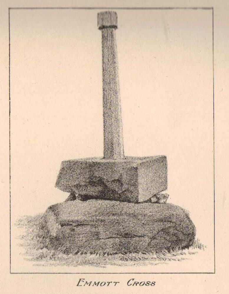
In the 19th century a fragment of an Anglo-Saxon cross was dug up in the grounds of Alkincoats Hall between Colne and Foulridge — this area was probably once an early Medieval settlement that was taken over by Knights Hospitallers in the 12th and 13th centuries. However, the carved cross-head was lost for a long period of time but was thought to have come to light again in more recent times when the sewerage works were being built at Swinden on the boundary between Colne and Nelson. If the cross had stood at Swinden then it almost certainly marked the boundaries between Colne and Marsden (Merclesden).
This fragment was thought to be almost certainly the same as that found at Alkincoats Hall. The piece of cross-head would have adorned the top of a late Saxon or early Medieval cross-shaft dating from the 10th-11th century. The carvings of knotwork interlacing on the arms and central boss were thought reminiscent of Anglo-Norse work — similar to the crosses at Whalley and Burnley.
I believe that the cross fragment was housed in St Bartholomew’s parish church at Colne, but I don’t know whether it still resides there. What a shame that the shaft has long gone – because almost certainly it would have looked resplendent.
References:
Byrne, Clifford H., “A Survey of the Ancient Wayside Crosses in North East Lancashire,” unpublished manuscript, 1974.
Taylor, Henry, The Ancient Crosses and Holy Wells of Lancashire, Sherratt & Hughes: Manchester 1906.
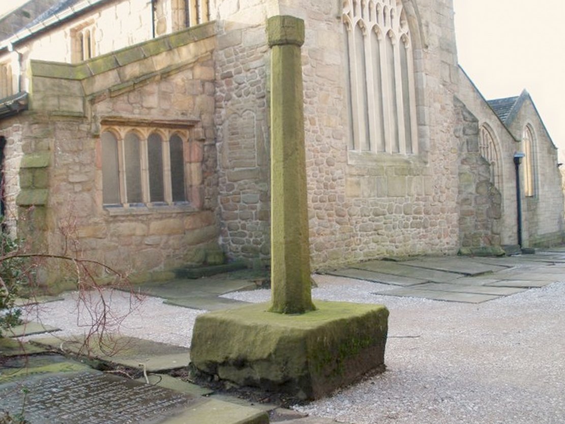
At the north side of St Bartholomew’s church-yard, Colne, stands the medieval Emmott Cross or Touch Cross. It was re-erected here in 1967 by local historian Mr Wilfred Spencer and a team of volunteers having being removed from the grounds of Emmott Hall, Laneshawbridge, when the old hall was being pulled down. The cross had stood for centuries close to the famous Hallown Well, both of which were highly venerated by pilgrims travelling between Whalley Abbey and Yorkshire. It appears that originally the cross had stood at the side of the Stanbury to Haworth road over Herders, close by Emmott.
The cross shaft stands 7 feet tall and is referred to as of the English Gothic style, probably 13th century. It stands in an octagonal socketed stone base which is 2 foot high and 4 foot square. Its slender octagonal shaft tapers away towards the top where there is a carved capital or corona – this may once have held a cross head or some other religious object. There used to be some faint lettering on the shaft but this has now worn away. A local historian Dr Whitaker described the lettering as “I.H.S.” along with the Greek omega symbol.
Taylor’s 1906 sketch
It was to all intent and purposes a preaching cross to which pilgrims would congregate and listen to the word of God and many would be baptised in the Hallown Well at the same time. In the penal times of the 16th century the cross was in great use, but by the 17th century it was being referred to as a “papist cross”. During this period in history it suffered damage and the shaft broken in two places; the cross-head taken away and smashed. For safety reasons the cross-shaft was removed to Colne church-yard but returned to the grounds of Emmott Hall in 1728 when relative calm had returned.
The slender cross shaft and its hefty base are said to weigh about 2 tons and I have no doubt it does. It is now grade 11 listed.
Folklore
The name Touch Cross probably comes about in the sense that pilgrims touched the cross in the hope of a safe pilgrimage, or the name may be something to do with a troop of soldiers who were stationed at the hall in the past. They touched the stone too, but for different reasons – that they would live to fight another day in battle.
References:
Byrne, Clifford H., “A Survey of the Ancient Wayside Crosses in North East Lancashire,” unpublished manuscript, 1974.
Taylor, Henry, The Ancient Crosses and Holy Wells of Lancashire, Sherratt & Hughes: Manchester 1906.
Whitaker, Thomas Dunham, An History of the Original Parish of Whalley and Honor of Clitheroe, Nichols, Son & Bentley: London 1818.
Take the road up to Brimham Rocks from Summerbridge; crossing the little crossroads, then keep your eyes peeled for the singular farmhouse on your right. Just beyond this, on your right, you’ll notice some small moorland opens up and reaches gently down the slope for some distance. Go along the footpath for 100 yards or so, then into the heather to your right, for 60 yards or so (as if you walking towards the farmhouse and small crags). This is where the following sites could be found. (when we visited Brimham recently, unfortunately sunfall stopped us having a proper wander here, so the status of the site/s remains unknown to us)
Archaeology & History
This little-known and possibly destroyed prehistoric site — less than a mile north of Standing Stone Hill and just a coupla hundred yards south of the legendary Brimham Rocks — has been described by several antiquarians from the early 19th century onwards. It’s an intriguing place, deserving of much greater antiquarian attention. Ely Hargrove (1809) appears to be the first who mentions prehistoric tombs here, though his sense of direction implies another site (unless he just got that part of it wrong?). Along with “several small tumuli or carns” near another section of Brimham Rocks themselves, he told there to be,
“Several large tumuli; one of which about 80 yards west of the great Cannon, measures 150 feet in circumference. It is worth remarking that the place where most of these tumuli are found is, at this day, called Graffa Plain, i.e., the Plain of Graves.”
These ‘tumuli’ were again mentioned briefly in passing by one ‘D.N.H.’ in the Gentleman’s Magazine of November 1823. The great Knaresborough historian William Grainge also described cairns here. They were then highlighted on the very first Ordnance Survey of the region in the 1850s and shown as “Supposed tumuli.” Eventually, at the turn of the 20th Century, they were explored at the behest of the local land-owner by Mr L.A. Armstrong. His description of what they found here is intriguing and well worth reproducing in full:
“By permission of the Right Hon. Lord Grantley, I was enabled to make a careful examination of two of the ancient burial mounds of ‘ Graff a Plain,’ Brimham Moor, on Tuesday, August 4th, 1908.
“Mound No. 1, of circular form, and about 12′ o” in diameter, is situated about 150 yards north-west of the first large group of rocks, upon the south-eastern boundary of the moor, and about 50 yards south-east of the trackway leading to ‘ Riva Hill Farm,’ and it occupies the summit of a slight hillock, upon a comparatively level portion of the heath, which rises rapidly to the south of it in a bold sweep, terminating in the outstanding rocks of Graffa Crags and Brimham Beacon.
“The entire absence of any heather upon the mound, and the profusion of bright green bilberry plants which covered it and at the same time rendered its outline more noticeable, told plainly of a different character of subsoil from that of the surrounding moor ; but prominent as the mound appeared, its actual elevation was deceptive, being barely two feet above the natural level, and the uneven character of the upper surface suggested previous disturbance to be more than probable. A few attempts to pierce the crown, however, proved it to be a cairn, constructed of large stones, and accounted for the prolific growth of the rock-loving bilberry which overspread it, as well as for the uneven character of the surface.
“The thick green covering was carefully stripped off in lengths and placed on one side, and the few inches of vegetable earth removed, revealing the cairn in an almost perfect state, formed of a series of large stones placed methodically in concentric rings, each stone slightly inclined towards the centre, and the whole mass interlocked together by their own weight. Large stones were placed around the outside forming the enclosing circle, which is almost invariably found in the case of earth-built tumuli, and a few of these had been visible before the covering was stripped.
“The construction of the cairn rendered it necessary to remove the stones from the outer ring first, and to work gradually towards the centre where the burial, if such existed, might be expected to lie. This proved no easy task, as the stones were so tightly wedged, and had each apparently been specially selected for the purpose. Almost without exception, they were about a foot in diameter, oblong or oval in form, and three to five inches in thickness, with flat surfaces and rounded edges. No marks of tools were visible on any, but all alike were either water-worn, or had been especially rubbed to their present form. The stone itself was the Millstone Grit of the surrounding moor, but fragments of stone of the form composing the cairn are not now to be found thereon readily, although a careful search might reveal such. Personally I am inclined to think that they have been transported from a considerable distance; that great care has been exercised in their selection is indisputable.
“When nearing the inner radius of the cairn, small fragments of charcoal were noticeable, but they were by no means in large quantities. There was also a layer of fine grey sand an inch or two in depth, which had apparently been spread over the natural surface of the ground, and the stones bedded therein. Sand of this kind is abundant in the vicinity of the rocks upon the moor.
“In the centre, large pieces of stone were piled around a rough circle of about 3′ 6” extreme diameter, and within these, large and small stones, all of the form previously noticed, were laid more or less upon their flat surfaces, and amongst them the grey sand and charcoal were very evident; pieces of the latter up to an inch square, being found.
“Upon the gradual removal of this central mass of stones, the presence of the unmistakable black ‘barrow earth’ became evident in a slight layer, perhaps an inch or an inch and a half in thickness, and spread over the whole area within the inner ring, the bottom of which had been paved with large flat stones. Amongst this earth very slight traces of a greyish white paste-like substance were”] visible, probably the decomposed remains of the bones after calcination. The deposit was carefully gathered together. Its removal bared the large stones forming the bottom of the grave, and these proved to be two in number, the largest being about 2′ o” across, and of a somewhat angular form ; strikingly different to those composing the cairn itself, for the edges were rough fractures, not rounded in any way. Apparently the surface soil had been removed from the ground upon which the cairn was built, for the upper face of the two stones forming the bottom was level with the natural ground surface adjoining, so far as could be ascertained, and these had apparently been laid down for the reception of the deposited remains.
“As there was every reason to believe that some portion of the ashes might have been placed in an urn, efforts were made to raise the stones above mentioned in hopes of a discovery. This was by no means easy, but by care and perseverance, it was at last accomplished, but only to meet with disappointment. Immediately beneath was a slight layer of ashes upon the natural ground surface, which latter showed very evident signs of fire, the bright yellow sand composing the substratum being calcined to a dark red colour for quite 2” in depth. This sand was very stiff and compact. The most diligent search failed to reveal any trace of a hole or other disturbance at any point, or of any implements which might have accompanied the body, either upon the surface or amidst the cairn.
“One stone found amidst those immediately covering the deposit, was remarkable because entirely different from all the remainder composing the cairn, and appeared to have been shaped with some definite object in view. It was a fragment of hard sandstone, in the form of a truncated pyramid, the sides and top being roughly fractured to shape, but the base was quite smooth, and bore marks of friction. The base measured 6″ x 5″, and the height about 4½”. This might have been used as a crushing and grinding stone for grain, or for rubbing purposes, but careful search failed to reveal its companion slab. With this exception, nothing was found that could be considered as having been fashioned for use, and there was nothing to throw any light upon the probable period of the cairn’s erection.
“The second tumulus examined is situated about 100 yards south-west of the first. It was of rather irregular shape, and appeared to have been somewhat disturbed, but the original diameter had probably been about 9′ o”. Upon examination, it also proved to be of the cairn type, and apparently similar to that previously opened, but it had been disturbed throughout at some distant period, and no trace of the deposit could be found, although the yellow sand forming the subtratum was noticeable, calcined over the whole area as before. There were also traces of charcoal. It is remarkable that amidst the smaller stones of this cairn another ‘ rubbing stone ‘ was found, almost identical with that in the former one, and similarly, this proved to be the only ‘ find ‘ of any description bearing certain traces of man’s handiwork.
“Although somewhat disappointing not to be able to assign the erection of these cairns to any definite period, yet their examination proves valuable for two reasons. First it places beyond any question the nature of the mounds scattered over this portion of Brimham Moor, which is known by the name of ‘ Graffa Plain,’ a name which the late Mr. William Grange translates as ‘ the place of graves ‘ — significant in itself, though he at the same time casts a doubt upon the formation of the mounds in question being anything other than natural. The identity of the grave mounds being established, they prove that a settlement of primitive man of no small magnitude must have been located somewhere in the vicinity.”
The word ‘graffa’ seems to be the plural for ‘graff’, which the english dialect magus, Joseph Wright (1900), convincingly assures us to derive from the old english, “græf, a grave, trench.” This seems confirmed by the common finding of ‘graff’ in regional dialects from Yorkshire, Lancashire and other northern counties, where it relates specifically to ‘graves.’ A variation on the word, as cited above, finds ‘graff’ occasionally relating to “a ditch or trench; a channel, cutting; a hole, pit or hollow.” The usually helpful A.H. Smith (1961-63) was curiously silent on this place-name; but local historians Grainge, Walbran and others tell us that Graffa Plain is simply “the plain of the graves.”
I know of no other accounts that have explored this site. Does anyone have any further information about this place?
References:
Armstrong, A. Leslie, “Two Ancient Burial Cairns on Brimham Moor, Yorkshire,” in The Naturalist, March 1909.
Hargrove, Ely, The History of the Castle, Town and Forest of Knaresborough, Hargrove & Sons: Knaresborough 1809.
Smith, William, “Yorkshire Place-Names,” in W. Smith’s Old Yorkshire – volume 1 (Longmans, Green & Co.: London 1881).
Wright, Joseph (ed.), English Dialect Dictionary – volume 2, Henry Frowde: London 1900.
The site has been known about for nearly 150 years, albeit mistakenly as a series of prehistoric barrows that William Greenwell (1877) told were “near the division between the parishes of Rudston and Burton Agnes” near the crest of the hill. He further told the place to be,
“Two long mounds, almost parallel, their northern end gradually losing themselves in the surface-level, but connected together at the southern end by another long mound.”
South end of Cursus A (after D.P. Dymond)Early photo of Cursus A (after J.K.St Joseph)
Then in 1958 when C. & E. Grantham of Driffield did the first modern excavation here across a section of the western ditch, they found that the long embankment went on much further than ever previously anticipated, for more than half-a-mile downhill in the direction of Rudston village. It wasn’t a long barrow or tombs of any sort, they found! Then in 1961 when Dr. J.K. St. Joseph did aerial survey work over the area, he and his colleagues established that this monument consisted of extensive parallel ditches stretching for at least 1½ miles towards and past the eastern side of Rudston village. It’s nature as a cursus monument was rediscovered after several thousand years in the wilderness… (on St. Joseph’s survey, two other cursus monuments were also found in the vicinity, being Rudston Cursus B and Cursus C) Readers will hopefully forgive me for quoting at some length Mr Dymond’s (1966) article on the site (with minimal editing!):
“The southern end of the cursus lies in the western angle of two roads, Woldgate and Burton Agnes Balk. In plan it is square with rounded corners and consists of a bank with outer ditch. Although the bank has been ploughed for many years, it still remains substantial; it stands up to 4 feet high from the outside and 1-2 feet wide from the inside. The east and west banks decline in height northwards and are now at their greatest height where they join the southern end. The profile of each bank is smooth and rounded and merges on the outside with the broad shallow depression of the silted-up ditch. The south bank is now 170 feet long overall, and spread to a width of 60-80 feet. It stands higher at both ends than in the middle. This fact was noted by Greenwell, who also recorded that at the southwest angle “there was the appearance of a round barrow raised upon the surface of the long mound.” There is no surface evidence today to suggest a secondary round barrow, and to some extent at least the greater height at the angles is probably due to the concentration of upcast inside a fairly sharp corner.
“The south arm of the ditch has been largely destroyed by a chalk-pit, but the southeast turn is quite clear on air-photographs. There is no suggestion on the ground or from the air that the cursus had ever extended further to the south.
“The cursus begins its descent in a due northerly direction, and loses its eastern side for approximately 600 feet under the enclosure road, Burton Agnes Balk. The ditch can be traced intermittently on the western and eastern verges. It then swings gently NNW around the head of a small slack draining northwest. Thus far the cursus is traceable on the ground. The ditches are the most consistent feature, showing as broad shallow depressions 20-40 feet wide and 70-80 yards apart, which when in fallow attract a dark coarse vegetation (particularly thistles and nettles. The banks inside the ditches are sometimes visible in relief though considerably spread. Where the banks have been almost entirely ploughed out, a chalk spread usually marks their position.
“There is a suggestion on the ground that the banks and ditches may have been separated by berms, particularly on the east side near the square end. This appears to be confirmed by the silting of the ditch in the excavated section…
“Proceeding further downhill in the direction of Rudston village, the cursus quite suddenly swings north-NNE, finally crosses Burton Agnes Balk, and passes to the west of Pits Plantation. On the west of the road both banks and ditches are still visible in relief, and the ditches produce a firm crop-mark. East of the road no surface traces are discernible, and only the eastern ditch shows intermittently as a crop-mark.
“For ½-mile across the floor of the Great Wold Valley, there is no trace of the cursus. The area has been ploughed since medieval times, and there is in addition a considerable Romano-British settlement. It is worth noting that in this length, the cursus must have crossed the stream of the Gypsey Race, surely a fact of some importance in any discussion of the function of cursuses.
“Two parallel ditches c.60 yards apart, visible on air photographs in a field immediately north of the modern Rudston-Bridlington road, seem to represent the continuation of the cursus. The ditches travel for approximately 300 yards and end at the Bridlington Gate Plantation. There are no surface traces in the field, but a depression in the plantation may represent the eastern ditch. This depression is crossed obliquely by the remains of a low bank and ditch running along the length of the plantation WSW and ENE. This latter (part) is probably part of the supposedly Iron Age entrenchment system, and has certainly been used as a road from Rudston to Bridlington, as the name of the plantation implies.
“The northern end of the cursus cannot be traced. Possibilities are that the end was in the plantation and has been destroyed by the later earthwork, or that the cursus proceeded NNE for an unknown distance. If the latter hypothesis is accepted, the western ditch must be under the Argam Dykes, a double entrenchment which appears to terminate at the northern side of the plantation, and the eastern ditch is indistinguishable from ploughing lines to which it is parallel…
“Cursus A has its southern end at a height of 254 feet OD, on the forward face of a long chalk ridge running WSW and ENE. From this point the course of the cursus is visible, except for that part west of Pits Plantation. The last known part in Bridlington Gate Plantation, 1½ miles off, is clearly visible. Seen against the contours of the area, the cursus has one end resting on a high ridge, crosses a broad valley, and climbs at least in part, the far side. It appears to pass approximately 300 yards east of the monolith in Rudston churchyard.”
Line of Rudston A
The presence of this and three other cursus monuments close by (Rudston B, C and D) indicates that the region was an exceptionally important one in the cosmology of our prehistoric ancestors. Four of these giant linear cursus monuments occur in relative proximity, and there was an excess of ancient tombs and, of course, we have the largest standing stone in the British Isles stood in the middle of it all. A full multidisciplinary analysis of the antiquities in this region is long overdue. To our ancestors, the mythic terrain and emergent monuments hereby related to each other symbiotically, as both primary aspects (natural) and epiphenomena (man-made) of terra mater: a relationship well known to students of comparative religion and anthropology who understand the socio-organic animistic relationship of landscape, tribal groups and monuments.
References:
Dymond, D.P., “Ritual Monuments at Rudston, E. Yorkshire, England,” in Proceedings of the Prehistoric Society, volume 32, 1966.
Eliade, Mircea, The Sacred and the Profane, Harvest: New York 1959.
Greenwell, William, British Barrows, Clarendon Press: Oxford 1877.
Hedges, John & Buckley, David G., The Springfield Cursus and the Cursus Problem, Essex County Council 1981.
Nicholson, John, Beacons of East Yorkshire, A. Brown & Sons: Hull 1887.
Pennick, Nigel & Devereux, Paul, Lines on the Landscape, Hale: London 1989.
Go thru Killin and, just past the Bridge of Lochay hotel, take the tiny road on your left. Go down here for 3 miles till you pass the gorgeous Stag Cottage (with its superb cup-and-rings in the field across the road) for another 300 yards, past Duncroisk Farmhouse set back on your right, then over the small river bridge. Just over the bridge there’s a gate on your left. Go thru this and up the track until you get to another large gate. Go thru this, then walk immediately left where you’ll notice a large-ish boulder sat on the nearby slope ahead of you in a part of some very old walling. That’s your target!
Archaeology & History
The title of this carving is slightly misleading, as the stone concerned is about 50 yards west of the fast-running burn. But it’s pretty easy to locate. When we visited the stone recently, as the photos show, the rock was all-but covered in a beautiful patchwork of lichen and moss, inhibiting the visibility of a quite impressive carving. But we have to let this be.
The carving’s on the big rock by tree, in the wallingLine of walling clearly evident
The carved rock plays an important part in a line of ancient prehistoric walling, which looks Iron Age in nature, but without an excavation we’ll not know for certain. The walling is quite extensive and is an integral part of the extended derelict village of Tirai, with its standing stones and other monuments. This begs the questions: was the carving executed before or after the walling was created? Was the stone carved in traditional neolithic/Bronze Age periods and later accommodated into the walling?
Even in the grey overcast light of a winter’s day when we first visited here, many cups were clearly visible on the rock’s surface, but they were difficult to contextualize in terms of artificial and natural aspects of the stone. Later visits here at the end of Spring enabled a much better assessment — though capturing the surrounding “rings” proved difficult. The carving is shown highlighted on Ron Morris’ (1981) map of the cluster of Duncroisk carvings, and described as a:
“domed schist boulder, 2½m by 2m, 1¼m high (8ft x 6ft x 4ft). On its top, mostly where sloping…are: 2, and possibly 3, cups-and-one-ring, much weathered and only visible when wet in very low sun, probably un-gapped, and at least 32 cups. Diameters up to 17cm (6½in) and depths up to 1cm.”
But this is only half the story. Despite what Mr Morris and the more recent Canmore records tell us about this carving, there are in fact at least 52 cups on the surface of the rock, at least two of which have definite ring-like forms around them. The largest of the cups has linear features around a large section of it, but to ascribe these elements as ‘rings’ is also stretching it a bit — as one of the photos here clearly shows. The ‘ring’ consists more of two separate straight lines with curvaceous ends: more like a right-angled carving with a swerve than any traditional ring. It’s a quite unique feature by the look of things.
Faint cup-and-ring and cups…and…Cups & right-angled lines
The majority of the carved cups and lines occur on the eastern side of the boulder, with only a few singular cups almost fading their way onto its western sloping sides. And of primary visual interest are the swirl of cups that surround two small cups at the ESE corner of the rock. These give the impression of running into another swirl of cups that hedge their ways around the edges of the largest cup-and-right-angled-lines, until bending back up and along the southern-side of the stone. This possibly deliberate sequence of cups then continues in roughly the same form back upwards to near the top-middle of the rock and onto a complete cup-and-ring. Just above the top of this runs a short pecked line just detached from the cup-and-ring, but of obvious mythic relevance in the story which this carving once told.
RWB Morris’ sketch of the design
It’s an absolutely fascinating carving which gives the distinct impression of narrating a myth of journeying, by either a person, tribes or ancestral beings. Of course we’ll probably never know for sure what story it once told; but its tale may have been known by the people of the once proud village of Tirai which was only destroyed a couple of centuries ago, along whose fallen walls this great stone still rests within…
And finally, for those students exploring the potential relationship that cup-and-rings may have with water: please note that in wet conditions, a spring of water emerges right underneath the very base of this large rock.
…to be continued…
References:
Morris, Ronald W.B., The Prehistoric Rock Art of Southern Scotland, BAR 86: Oxford 1981.
Royal Commission on the Ancient & Historical Monuments of Scotland, Archaeological Sites and Monuments of Stirling District, Central Region, Society of Antiquaries of Scotland 1979.
If you follow the directions to reach the Churn Milk Joan stone, then continue onto the moor following the same directions to find the Miller’s Grave, once you’ve reach this you’ll see a large rounded boulder a couple of hundred yards away on your left, to the northwest. That’s Robin Hood’s Penny Stone!
Archaeology & History
Robin Hood’s Pennystone, Midgley Moor
In terms of this site’s archaeology, it has none to write home about in official records (other than a few flints found nearby), but there’s more to this place than meets the eye. A large rounded boulder sat upon the moorland plain with a large Nature-worn bowl on its top, the site is some 112 yards (102m) northwest of the little-known, but impressive Miller’s Grave prehistoric cairn (close to being a midsummer/midwinter line). North and south of the rock are small lines of prehistoric walling — though their context is difficult to assess. The Greenwood Stone and Greenwood B stone can be found about 200 yards west.
Folklore
A singular footpath once led up to this old boulder, atop of which – in its large ‘bowl’ – vinegar used to be poured. In this, coins were left by local people who suffered the plague and in return food was left for them. And of course it is said that Robin Hood frequented the place in bygone times.
References:
Bennett, Paul, The Old Stones of Elmet, Capall Bann: Milverton 2001.
Robert, Andy, “Our Last Meeting,” in NEM 37, 1989.
Robert, Andy, Ghosts and Legends of Yorkshire, Jarrold: Sheffield 1992.
To be found on the wooded hill about 160 yards north of Wallstale Farm, on the Polmaise Road on the western side of the M9, a mile or so south of Cambusbarron, below the hugely impressive Murrayshall Quarries. Walk up the steep slope into the woodland and when you reach the level you’ll find the stonework remains. It’s on the edge of the slope in the trees.
Archaeology & History
This old fortified walled structure is best seen in the winter months when all the vegetation has fallen back to Earth. If you come here in the summer, the woods are nice but the monument can’t be seen as clearly. Found at the top of the slope above the roadside, it was described in the Stirlingshire Royal Commission (1963) account as follows:
Ground-plan of Wallstale Dun (after RCAHMS 1963)Wallstale Dun, up there somewhere!
“It is almost circular in plan…measuring about 45ft in diameter within a ruined stone wall some 11ft in thickness. Except on the ESE side, where the entrance was probably situated, the wall can be traced continuously by patches of rubble core, and round the east half outer facing-stones are visible up to a maximum height of four courses. In contrast, the inner face is only exposed for a short distance on the ENE. The interior of the dun is featureless. On the NW side the dun is protected by a rock-cut ditch of substantial proportions which traverses the spur; it measures 26ft in width at the top and the scarp is 5ft 6in in depth.”
References:
Royal Commission on the Ancient & Historical Monuments Scotland, Stirling – volume 1, HMSO: Edinburgh 1963.