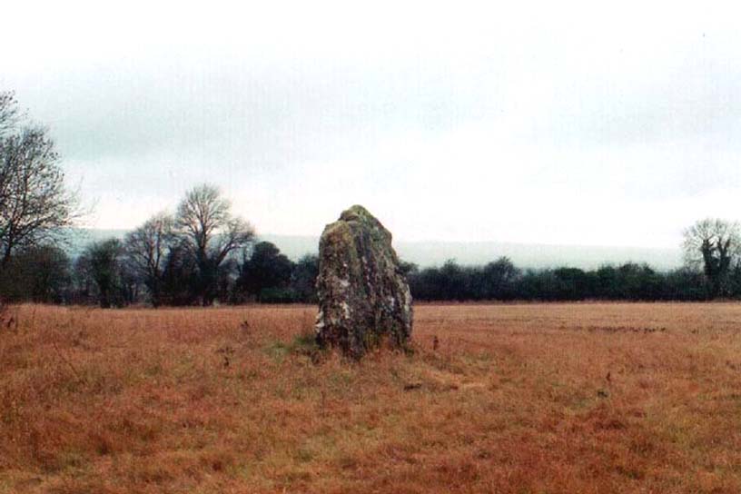
Borough Hills necropolis, West Mersea, Essex

Tumuli (destroyed): OS Grid Reference – TM 022 143

Also Known as:

  1. Barrow Hills
  2. Five Barrows

Archaeology & History

Known as Five Barrows presumably from the five main burial mounds that were once here, very little in modern texts seem to describe them.  In the grid-reference given above, I’m not 100% certain that this is the correct spot – and as many of them have been destroyed, we’ll stick to this until someone tells us otherwise! (it is only Essex anyway)

The ‘barrow’ site that remains has been ascribed as Romano-British in date, whilst the others don’t seem to get a modern mention.  These missing barrows were described in a short article in The Gentleman’s Magazine by a Mr J.A. Repton (1840), who told the following:

“In reading an account of Essex, I find the following Borough, or rather Barrow Hills, on the north side of the Black Water Bay, were considerable in number. These tumuli are supposed to have been raised indiscriminately over the bodies of the Danes and Saxons that fell in the battles occasioned by the frequent landing of the former in this part of the coast. The lands on which the barrow hills stood were completely inclosed from the sea in 1807, and the whole are now levelled, one excepted.

“This barrow I heard was going to be cleared away for manure. I made a point of visiting it under an idea that it might be proved a Roman one; when I arrived at the spot, I found it to be a bowl barrow, about 14 yards diameter, and about 6 or 7 feet high, and rather more than half of it cut away, and what surprises me, not a single urn, bone, or ashes, nor any mark to be found; perhaps the barrows being mostly under water during the tide may account for the disappearance of bones, etc., if there ever were any placed; or rather that the Danes and Saxons were not so careful as the Romans in preserving the remains of their friends. I met one of the old inhabitants who lived in the parish more than forty years; he remembered the number of barrows being destroyed, and said not a single bone or urn was ever found in them.

“Perhaps you can give me some information, whether by digging below the natural surface of the ground, any remains may be traced. It is not a gravelled, but a clean, light clay soil. The land is low and marshy, and celebrated for Maiden salt, and near it there is a decoy. ”

If anyone has further information about the other barrows which are described in several old early accounts, it’d be good to know!

Folklore

Archaeologist and folklorist Leslie Grinsell (1976) noted briefly that the barrows here supposedly covered the remains of Danes who died in battle here.

References:

  1. Grinsell, Leslie V., Folklore of Prehistoric Sites, David & Charles: London 1976.
  2. Repton, J.A., “Borough Hills, Essex,” in The Gentleman’s Magazine, 1840 (part 2, p.114).

© Paul Bennett, The Northern Antiquarian 

Eyam Cross, Eyam, Derbyshire

Cross:  OS Grid Reference — SK 2178 7639

Getting Here

The village of Eyam is located some 9 miles south-east of Chapel-en-le-Frith and about the same from Sheffield, which lies to the north-east. Go to the centre of the village and find the church of St Lawrence standing beside the road to Foolow close to Eyam Hall and just west of the B6521 road to Sheffield.  The Saxon cross stands in the churchyard.

History and Folklore

Eyam Cross, east face (from Wikipedia)

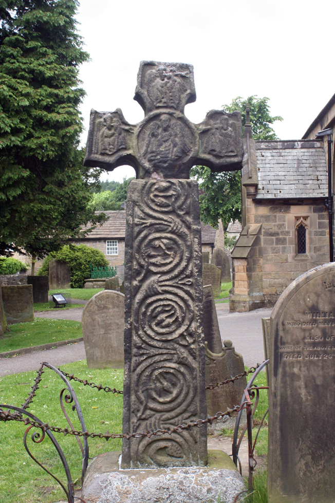
This very fine Anglo-Saxon (Mercian) cross stands 8 foot tall and dates from the 8th-9th centuries. It was apparently set up by missionaries from the north at Cross Low on the moors to the west of Eyam. Originally it was a wayside preaching cross that was 10 feet high and certainly must have looked very spectacular, but now it is only 8 feet high due to it being knocked about a bit in more recent times and losing one of its shaft sections. In the 18th century the cross was discovered beside a trackway on the moors, from whence it was brought to the churchyard of St Lawrence’s church;  but then for a long time it stood abandoned and uncared for in the corner of the churchyard. Eventually  it was restored and placed in the churchyard where it now stands proudly.

The cross is said to be the only one of its type in the Midlands that retains its cross-head. It has some very rich decoration on the west face with fabulous interlacing scroll-work running up the shaft that is typically Mercian in origins. On the west-face, especially the upper section, there are human figures probably St Mary the Virgin with the baby Jesus, angels and Christ in glory, each in their own sections or panels. The cross is grade 1 listed.  St Lawrence’s church houses a Saxon font.

References:

  1. Rev. Arthur, C., Illustrated Notes on English Church History, Society for Promoting Christian Knowledge: London 1901.
  2. Rodgers, Frank, Curiosities of Derbyshire and the Peak District, Derbyshire Countryside Ltd 2000.

Copyright ©  Ray Spencer 2011 


Swinden Cross, Colne, Lancashire

Cross:  OS Grid Reference – SD 878 409

Archaeology & History

Carved cross design

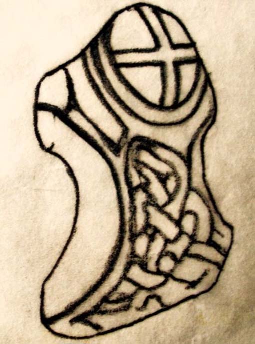
In the 19th century a fragment of an Anglo-Saxon cross was dug up in the grounds of Alkincoats Hall between Colne and Foulridge — this area was probably once an early Medieval settlement that was taken over by Knights Hospitallers in the 12th and 13th centuries.  However, the carved cross-head was lost for a long period of time but was thought to have come to light again in more recent times when the sewerage works were being built at Swinden on the boundary between Colne and Nelson. If the cross had stood at Swinden then it almost certainly marked the boundaries between Colne and Marsden (Merclesden).

This fragment was thought to be almost certainly the same as that found at Alkincoats Hall.  The piece of cross-head would have adorned the top of a late Saxon or early Medieval cross-shaft dating from the 10th-11th century. The carvings of knotwork interlacing on the arms and central boss were thought reminiscent of Anglo-Norse work — similar to the crosses at Whalley and Burnley.

I believe that the cross fragment was housed in St Bartholomew’s parish church at Colne, but I don’t know whether it still resides there. What a shame that the shaft has long gone – because almost certainly it would have looked resplendent.

References:

  1. Byrne, Clifford H., “A Survey of the Ancient Wayside Crosses in North East Lancashire,” unpublished manuscript, 1974.
  2. Taylor, Henry, The Ancient Crosses and Holy Wells of Lancashire, Sherratt & Hughes: Manchester 1906.

© Ray Spencer, 2011


Lyneham Barrow, Ascot-under-Wychwood, Oxfordshire

Long Barrow:  OS Grid Reference – SP 2975 2107

Getting Here

Lyneham Barrow stone

Pretty easy really.  From Shipton-under-Wychwood take the A361 road north (to Chipping Norton) for just over 2 miles.  You’ll pass the TV mast on your right and then a small country lane sign-posted to Ascott-under-Wychwood.  Go past this and then stop at the next right-turn a half-mile further up the road.  The barrow is about 100 yards before this turning, in the hedgerow, on the left-hand side of the road!

Archaeology & History

This once great and proud neolithic monument is today but a shadow of its former self.  Described by various antiquarians and archaeologists over the years, O.G.S. Crawford (1925) included it in his fine survey, telling:

“The barrow is between 160 and 170 feet long and stands in two fields on the west side of the Chipping Norton and Burford main road… In the northern field, at the NE end of the barrow, stands a single upright stone, 6 feet high, 5 feet broad and 1 foot 6 inches thick.  This stone is stated to be buried three feet deep in the ground and its height is given by Conder as 10 feet 6 inches.  When visited October 18, 1922, a large piece of the top had been broken off, but replaced in position.”

This damage was reported around the same time and described in the early “Notes” of The Antiquaries Journal by a Mr A.D. Passmore (1925), who wrote:

“About 30ft from the north-east end of this long barrow stands a large monolith now nearly 6ft above ground…and roughly 6ft wide and just under 2ft thick, of local stone.  At the top is an ancient and natural fissure extending right across the stone and penetrating some way downwards obliquely.  Early in 1923, either by foul play or natural decay, another crack appeared spreading towards the first about a right-angle, the result being that a large piece at the top of the monolith became detached.  Such an opportunity of mischief was speedily taken advantage of and the piece of stone, weighing over 4 cwt, was pushed off and fell to the ground.  In August 1924 the owner of the land, his man, and the writer spread a bed of cement and hoisted up the large broken mass and relaid it in its bed.”

But even in their day, the tomb had already been opened up and checked out, by a Lord Moreton and a Mr Edward Conder, in 1894 no less!  Conder’s account (1895) of the inside of this ancient tomb told:

“There were found (1) a chamber at right angles to the long axis of the barrow; on the south-eastern side of the barrow were two uprights, 4 feet 2 inches by 2 feet 1o inches, and 1 foot 9 inches by 2 feet 8 inches.  At the north-western end of the chamber were two uprights set with their long faces (edges?) abutting.  On the surface-line at the level of the base of the barrow were traces of paving and fragments of bone, pottery and charcoal.  (2) Chamber, a little south of the south-east corner of No.1,  slightly above the ground level.  It was formed of three uprights, on the north, east and west sides respectively, and a paving slab with a perforation 4 inches in diameter.  At the north-eastern end of the barrow was a ridge of large ‘rug’ stones up to 8 feet long, 5 feet wide, and 2½ feet thick, terminating in a standing stone…10 feet 6 inches high…buried 3 feet below ground level.  At the southwest end was a standing stone, 4½ feet by 3 feet by 11 inches thick, in a horizontal position lying east and west, 2 feet below the surface. At various points were found skulls and human and animal bones and hearths, with no indications of date, and (as secondary interments) two Saxon graves.”

Today, poor old Lyneham Barrow is much overgrown and could do with a bittova face-lift to bring it back to life.  But I wouldn’t hold y’ breath…..

Folklore

At the crossroads just above this old tomb, the ghost of a white lady is said to roam.  And at the old quarry on the other side of the road a decidedly shamanistic tale speaks of an old lady who lived in a cave and guarded great treasure!  Her spirit is sometimes seen wandering about in and around the fields hereby.

References:

  1. Bennett, Paul & Wilson, Tom, The Old Stones of Rollright and District, Cockley: London 1999.
  2. Brooks, J.A., Ghosts and Witches of the Cotswolds, Jarrold: Norwich 1992.
  3. Conder, Edward, “An Account of the Exploration of Lyneham Barrow, Oxon,” in Proceedings of the Society of Antiquaries, volume 15, 1895.
  4. Crawford, O.G.S., Long Barrows of the Cotswolds, John Bellows: Oxford 1925.
  5. Dyer, James, Discovering Regional Archaeology: The Cotswolds and the Upper Thames, Shire: Tring 1970.
  6. L.V. Grinsell’s Ancient Burial Mounds of England, Methuen: London 1936.
  7. James, Dave, “A Brief Foray into Oxfordshire,” in Gloucestershire Earth Mysteries 14, 1992.
  8. Passmore, A.D., “Lyneham Barrow, Oxfordshire,” in Antiquaries Journal, 5:2, April 1925.
  9. Turner, Mark, Folklore and mysteries of the Cotswolds, Hale: London 1993.

© Paul Bennett, The Northern Antiquarian

Caratacus Stone, Winsford, Somerset

‘Standing Stone’:  OS Grid Reference – SS 8896 3355

Getting Here

You can’t really miss this.  Take the road south from Winsford, up the steep hill onto the moors and before you reach the crossroads, look up across the slope on your left where you’ll see a small building on its own.  Go there!

Archaeology & History

A curious upright monolith more than five feet long (though some of this is embedded in the ground) with the words ‘CARAACI NEPVS’ carved on one side, is strangely closetted in a silly ‘house’ of its own on the moortops!  But the origins and history of the stone are contentious.  Some proclaim it as prehistoric, others Romano-British, and others as being from the Dark Ages.  In the 1960s and ’70s, archaeological tradition had its origins in the Romano-British period, and certainly the carved lettering on the sides of the stone seem to indicate a Roman provenance; but as the great Exmoor historian S.H. Burton (1974) told,

“It is possible that the stone was erected hundreds of years before it was inscribed, and the existence of an ancient trackway alongside, leading to the Barle, strengthens this possibility.  But, like most things about the Caratacus Stone, this is guesswork.”

We know it stood here in the 13th century as it was described in perambulation records of 1219 and 1279 AD; but it’s more than likely to be a monolith erected in the Dark Ages.  Grinsell (1970) however is a little more cautious, telling:

“The likelihood of the person in whose memeory this stone was raised claiming kinship with the Caratacus who was the arch-enemy of Rome, c. AD 45-50, has on more than one occasion been questioned.  It is, however, too tempting to be abandoned by the present writer.”

The carving on the stone was deciphered by the legendary Prof. John Rhys at the end of the 1800s, telling it to have been Carataci Nepos, the Kinsman of Caratacus (and variants thereof), who held out against the Romans in south Wales until AD 50.  The old Celtic writer, R.A.S. Macalister, thought the stone to have been dedicated to a local christian hero, St. Carantoc, but this notion has been generally dismissed.

Folklore

The old stone is said to be a site where buried treasure exists — though none has ever been found.  There is also an old tradition that “ghostly horses and waggons rumble towards the stone at midnight” — but this as likely relates to its proximity with the old crossroads a short distance away.

References:

  1. Burton, S.H., Exmoor, Hale: London 1974.
  2. Grinsell, L.V., The Archaeology of Exmoor, David & Charles: Newton Abbot 1970.
  3. Page, John Lloyd Warden, An Exploration of Exmoor and the Hill Country of West Somerset, Seeley 1890.
  4. Vowles, Alfred, History of the Caratacus Stone, privately printed 1939.

© Paul BennettThe Northern Antiquarian