Stone Circle (destroyed?): OS Grid Reference – SD 892 367
Archaeology & History
Set in good landscape with fine views in most directions, it seems that the only thing that remains of this site is a place-name on a map—but I have to say that our search here was only a short one, and so more may be found hiding away in field walls or beneath the ground. However, if we listen to an early account of the place, it was said to have “completely gone by 1856.” A pity, as it was described as being “a large circle of stones.” The monument was used for repairing the nearby road and, in another account, we are told that the stones were added to the walls. Whether this was a cairn circle or a free standing stone circle isn’t known. The prevalence of tumuli close by at Catlow, Burwains, etc, would suggest a cairn circle, yet we have no accounts of human remains here… A puzzle.
References:
Barnes, Bernard, Man and the Changing Landscape, Liverpool University 1982.
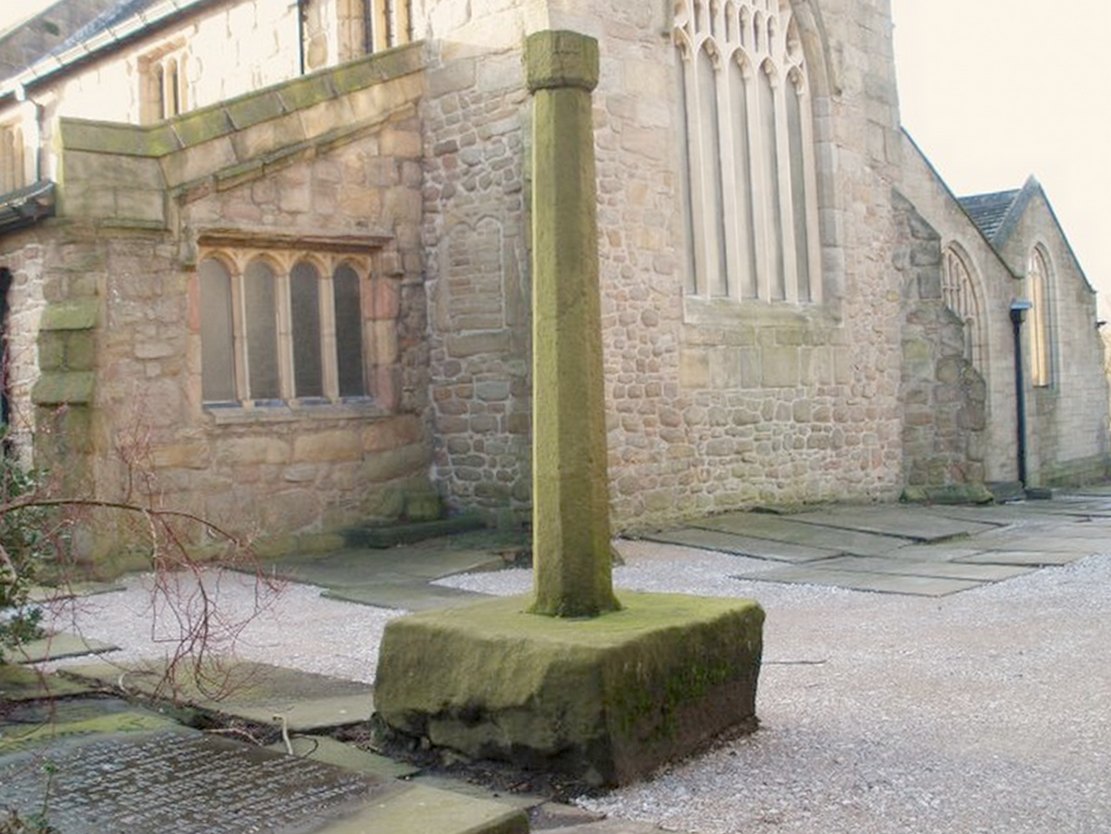
At the north side of St Bartholomew’s church-yard, Colne, stands the medieval Emmott Cross or Touch Cross. It was re-erected here in 1967 by local historian Mr Wilfred Spencer and a team of volunteers having being removed from the grounds of Emmott Hall, Laneshawbridge, when the old hall was being pulled down. The cross had stood for centuries close to the famous Hallown Well, both of which were highly venerated by pilgrims travelling between Whalley Abbey and Yorkshire. It appears that originally the cross had stood at the side of the Stanbury to Haworth road over Herders, close by Emmott.
The cross shaft stands 7 feet tall and is referred to as of the English Gothic style, probably 13th century. It stands in an octagonal socketed stone base which is 2 foot high and 4 foot square. Its slender octagonal shaft tapers away towards the top where there is a carved capital or corona – this may once have held a cross head or some other religious object. There used to be some faint lettering on the shaft but this has now worn away. A local historian Dr Whitaker described the lettering as “I.H.S.” along with the Greek omega symbol.
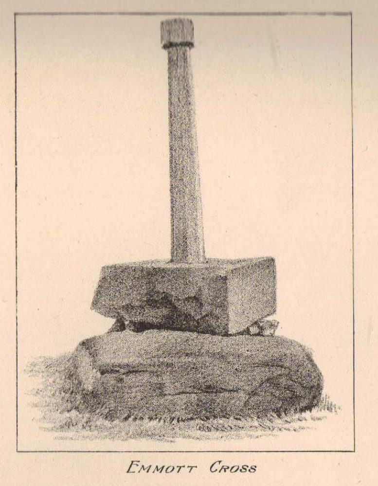
Taylor’s 1906 sketch
It was to all intent and purposes a preaching cross to which pilgrims would congregate and listen to the word of God and many would be baptised in the Hallown Well at the same time. In the penal times of the 16th century the cross was in great use, but by the 17th century it was being referred to as a “papist cross”. During this period in history it suffered damage and the shaft broken in two places; the cross-head taken away and smashed. For safety reasons the cross-shaft was removed to Colne church-yard but returned to the grounds of Emmott Hall in 1728 when relative calm had returned.
The slender cross shaft and its hefty base are said to weigh about 2 tons and I have no doubt it does. It is now grade 11 listed.
Folklore
The name Touch Cross probably comes about in the sense that pilgrims touched the cross in the hope of a safe pilgrimage, or the name may be something to do with a troop of soldiers who were stationed at the hall in the past. They touched the stone too, but for different reasons – that they would live to fight another day in battle.
References:
Byrne, Clifford H., “A Survey of the Ancient Wayside Crosses in North East Lancashire,” unpublished manuscript, 1974.
Taylor, Henry, The Ancient Crosses and Holy Wells of Lancashire, Sherratt & Hughes: Manchester 1906.
Whitaker, Thomas Dunham, An History of the Original Parish of Whalley and Honor of Clitheroe, Nichols, Son & Bentley: London 1818.
Follow the directions to reach the Herder’s Cross, not far away. Standing on the Herder’s Cross stone, look across the fields to the north (away from the farmhouse on the hill below) and you’ll see a nice-looking stream a coupla hundred yards ahead of you. Crossing this stream you see the large boulder, which you can see clearly if you’re stood on the Herder’s Cross. That’s where you’re heading!
Archaeology & History
A curious entry inasmuch as I’ve found no other references to the place. It’s an obvious cross-base, albeit very worn, cut onto the top of this large boulder, as you can see in the photo. What may be a singular cup-marking (if you’re a New-ager, or work for English Heritage that is!) is on the western side of the rock — but without additional markings on the rock, this has gotta be questionable.
Dodgy cup-marking on top!Shallow cross-base
The cut ‘square’ measures eight-inches both sides, but it seems that the cutting on the north-eastern sides of the base was never finished. The depth of the cross-base is also very shallow, only an inch deep. There seems to be a distinct possibility that this particular stone was initially chosen as a wayside cross marker, then for some reason perhaps moved to the position of the Herder’s Cross in the fields 420 yards (383m) to the south of here.
Clifford Byrne (1974) suggested that the pathway hereby was an ancient routeway that led towards the Emmot Holy Well, three-quarters of a half-mile down the hillside from here. Any further info or thoughts on this side would be most welcome.
References:
Byrne, Clifford, A Survey of the Wayside Crosses in North East Lancashire, unpublished manuscript, 1974.
Tumulus (destroyed): OS Grid Reference – SD 884 367
Archaeology & History
Long since destroyed, we are thankful to the writings of Thomas Booth (1899) that this site was recorded. In his rare work on the prehistoric burial sites of the region he told us how this tomb was unearthed,
The Catlow urn
“in March 1854, at Catlow quarry, in Marsden (Heights), a few miles across the hills from Todmorden in the direction of Colne, where a number of workmen who were engaged baring the rock came across two or three cinerary urns. These were very carelessly handled by the men, and as these vases are almost always made of clay only partially baked…they are very easily broken; the result, therefore, of the rude treatment of the quarrymen was that the vessels were broken to pieces.”
The mound from which the urns had been dug was also destroyed, but apparently the last remnants of the urns were presented to the Burnley Literary Institution sometime in the late 1890s — though where they’ve travelled since then, 120 years on, I have no idea!
References:
Bennett, Walter, The History of Burnley – volume 1, Burnley County Council 1946.
Booth, Thomas, Ancient Grave Mounds on the Slopes of the Pennine Range, R. Chambers: Todmorden 1899.
From Colne train station, cross the road and go along Bridge Street and where it meets Knotts Street follow it all the way up into the countryside and, bending to the right, uphill again until it levels out. The farmhouse a few hundred yards ahead of you (just off Southfield Lane) at the bend in the road is where you’re heading. There’s a track on your right, just before the farm. Go on this and look into the field immediately right. The undulations and earthworks are the remains of this old hillfort!
Archaeology & History
This old site was constructed some 850 feet above sea level, overlooking the valley of Colne immediately west and giving commanding views of the outstretched landscape towards the sacred Pendle Hill and beyond for many miles. The place was described as early as Castell Clif in 1515, and then again as Castyclyff in 1533, meaning simply the “castle on a cliff” or high verge as it is here. Yet despite its early appearances in literary studies, the first real work to explore this monument doesn’t appear to have been done until one J.A. Plummer carried out work on the site between 1958-60. However, Plummer died before being able to publish his findings in full. Ascribed variously as a settlement, an enclosure, and generally in the archaeological fraternity as a hillfort, the first detailed published description of the site was done by Forde-Johnston (1965), where he told:
Forde-Johnston’s early plan
“The hillfort is a very regular oval in shape and encloses an area about 350ft long and 250ft wide. The overall dimensions are 550ft by 450ft. The site has been affected by quarrying on the south and east and there are a number of gaps in the defences on the northern and western sides. The character of the remains differs in various parts of the site, but the general pattern appears to be as follows. The innermost line of defence is represented by a very slight bank or, in many places, only a very shallow scarp which can be traced round the whole circuit of the site… The second or middle bank is the most prominent or substantial of the three. It has considerable gaps in its length, but the various portions are all of much the same character — it rises between 3 and 5ft above the interior and falls about 9ft to the ditch bottom. On the south side the middle rampart takes the form of a scarp about 10ft high, immediately below the scarp of the inner rampart. The third, outermost bank is, in fact, a counterscarp bank to the second ditch. It does not exist as a continuous bank around the whole of the site, but there are sections of it on the northern and eastern sides. On the eastern and northeastern sides, from which approach was easiest, there appear to have been additional outer defences, situated about 70ft forward of the counterscarp bank. These outer defences now take the form of a scarp about 4ft high curving round the eastern and northeastern sides for about 250ft. At the southern end there is an inner scarp, forming a bank, and a little to the south, is a detached portion of bank. There are other short detached sections of bank on the northern side which are presumably to be connected with these outer defences.”
When Mr Plummer did his excavation here a few years before, one section of the site was examined and, thanks to the survival of an interim report he did — described by D.G. Coombs (1971) — we know the following of what he did:
“His work was concentrated in the northwest corner of the site where he cut a trench through the defences. Outside the counterscarp bank, which was not continuous, there was a bedding trench, packed with stones and containing charcoal. The ditch, which was rock-cut and flat-bottomed, had a homogenous fill. The rampart itself showed timber supports at the front and back with traces of stone revetting at the front and some distance from the timber uprights. The rear of the rampart was marked by a line of stones. Behind this rampart the site had been extensively disturbed and here he claimed to have found traces of primitive iron-smelting furnaces constructed from stones packed and sealed with loose black earth. A single post-hole beneath the rampart was suggested to belong to an earlier phase.”
Though we have to note here that Mr Plummer believed that the iron furnace remains were actually medieval in date, but that the embanked settlement itself was Iron Age and “that the collapse of the fort could be dated between 60-90 AD.” When Mr Coombs and his team came back here in 1970 to re-examine the works of both Plummer and Forde-Johnston, they confirmed some of their earlier finds, but uncovered additional finds at what they called this “once great fortress.”
Folklore
In Robert Lord’s (1976) superb imaginary piece on what he calls the Pendle Zodiac (a zodiac allegedly forged into the landscape in ancient times, in the manner of the famous and equally imaginary Glastonbury zodiac), a section of the deity Diana is made up of this prehistoric earthwork:
“The lower edge of the cap (on her head) coincides with a minor road between Colne, skirting the Iron Age Castercliffe hill-fort, above Nelson, as far as Catlow.”
Cross (destroyed): OS Grid Reference – c. SD 881 353
Archaeology & History
Not included in the magnum opus of Henry Taylor (1906), the exact position of this long lost site remains unknown, as even the investigative abilities of Clifford Byrne couldn’t track it down! It was erected in a region full of pre-christian remains and (at the time) living remnants of heathen folklore and practices between Worsthorne and Nelson. Mr Byrne (1974) described his search for the place, saying:
“This cross is of ancient origin and no part of it now remains as far as can be ascertained by investigation, although the memory of it certainly remains, for an elderly gentleman living in the cottages of Holt Hill, Briercliffe, said instantly on being asked about he cross that he had often heard it referred to by older people when he was a boy, although he could not say exactly where in the hamlet the monolith had stood. We are told that the cross is mentioned in a document in the year 1313 when Robert Briercliffe granted away the Sene intacks in the Holt Hill as it lay by Annot Cross on the south side. This implies that it stood on the south side of the road (between) Thursden and Haggate, which is an old road from Burnley to Halifax…”
This would give a rough grid reference for its position around SD 881 353, but nothing appears to be there. However, Byrne told of another intriguing bitta folklore a short distance away which may have had some relevance to the positioning of the cross.
“Down the road to Lane Bottoms, behind some bungalows, is a stone shaft in a depression in a meadow which we are told is an ancient standing stone. Whether this is so is not easy to ascertain for the stone has apparently been used as a gatepost at some time, and further gives indication of having been utilised as a cattle rubbing post.”
Below here we find the old place-name ‘Burwains,’ which clearly indicate a site of a prehistoric burial, though nothing remains of such a place — officially at least. Perhaps a couple of ventures in and around this area need to be done! One final note that Byrne made related to the title of this lost cross, saying:
“The name “Annot” may be of Saxon origin, for the Saxon word annet means solitude, and this would have certainly fitted the area in ages past.”
References:
Byrne, Clifford, A Survey of the Ancient Wayside Crosses in North-East Lancashire, unpublished report 1974.
Taylor, Henry, The Ancient Crosses and Holy Wells of Lancashire, Sherratt & Hughes: Manchester 1906.
From Laneshaw Bridge, near Colne, take the long country road that goes up above Wycoller to Stanbury and Haworth over the Yorkshire-Lancashire border. A couple of miles uphill, there’s a parking spot with views across the moors. Stop here. Cross the road and walk up for about 100 yards, going thru the rickety gate on the left, and up the field (past the small disused quarry) until you see the large rock looming ahead of you, perched on its own. That’s it!
Archaeology & History
Herders Cross stone
This is a really curious spot to me. A large singular boulder sat on the edge of an uninhabited moorland with no real history of heathenism, nor religious practices; yet someone at sometime in the not-too-distant past saw something here that made them cut a large square hollow into the top of this stone, in which they stuck an old cross. We came across this site a few weeks ago quite by accident, but realised that the deep hollow in the rock was an old cross base; so when I got home I checked Taylor’s (1906) magnum opus, expecting to find some info therein. But even Taylor seemed to know nothing of this place.
A week or two later, Paul Hornby pointed me in the direction of an unpublished essay by a local chap called Clifford Byrne (1974) who’d studied some of the early christian remains in the region and who wrote the following of what he named “Herders Cross”:
“This cross, or more properly its socket, is probably one of the least known in the area. It was shown to the writer by Mr Stanley Cookson of Trawden, who discovered the socket in passing, so to speak. On the road to Haworth from Laneshawbridge, opposite the site of Foster’s Leap rocks, on the east side of the road, is a really huge boulder on the moor top. In the south side is the cross socket, whilst on the north side of the rock can be made out a right-angled mark which implies that either the socket was being placed on that side in the first instance, or that two sockets were once envisaged…
“Old maps show the rock in situ with a “shaft” protruding from the top. Some yards west a shallow pony track bypasses the site, whilst some four or five hundred yards east a very well worn and ancient road, long unused, passes in the direction of Emmot Holy Well. The cross may thus have been a Wayside Cross showing the way to this Holy spring which is remembered as being propitious in the cure of rheumatism.”
Cross-base socket
This may be so; but I suspect earlier, heathen remains upon the moors here to explain the curious position of both this and another cross-base some 400 yards away. Some dubious cup-marks can be seen by the side of the stone hollow; and other dubious ones have been found on the moors above here. There is folklore of a lost stone circle on the hills above here, and a scattering of little-known faerie lore, indicating hidden sites and lost myths. These ingredients are more likely the reasons that Herders Cross was erected here, overlooking the countryside south and west, with the holy hill of Pendle rising in the centre of the distant landscape…
References:
Byrne, Clifford, A Survey of the Wayside Crosses in North East Lancashire, unpublished 1974.
Taylor, Henry, The Ancient Crosses and Holy Wells of Lancashire, Sherratt & Hughes: Manchester 1906.
This site can be reached with relative ease from Colne’s train station by crossing the road and going up Bridge Street, turning immediately left along Shaw Street for several hundred yards until you reach Waterside Road on your left-hand side. From here, as Mr Tom Sharples told, “St. Helen’s Well is presently within the area of overgrown and unmanaged scrub woodland adjacent to Waterside Road.” Look around!
Archaeology & History
First described on the Megalithic Portal by the pseudonymous Brionnfhionn, this recently rediscovered holy well can be found on the southern side of Colne, at Waterside. A few months after the MegPortal announcement, a more detailed overview of the site was published on GoogleDocs, from where Mr Tom Sharples has kindly allowed us to repeat the information that both he and Susan Bryant-Lauder compiled there.
The site was relocated after reference had been found in Geoff Crambie’s (1978) A Colne Festival, where he wrote:
“1935 saw the end of St. Helen’s Mill in Waterside. Built by Nicholas England in 1835, it was named after the St. Helen’s Well nearby, which was reputed to have been named by the Romans.”
The local writer Dorothy Harrison (1988) also mentioned the site, though only in passing, when she told,
“Along with St. Helen’s Well, Buck Spout provided the main source of drinking water in Waterside.”
There has to be some more information about this little-known site hidden in some old Lancastrian history or folklore work, somewhere – surely!?
References:
Crambie, Geoff, A Colne Festival, Turner & Earnshaw: 1978.
Harrison, Dorothy (ed.), The History of Colne, Pendle Heritage Centre 1988.
Easy enough to find once you’ve actually got to Wycoller. By car, the only real way to get here is from Colne, through the village of Winewall, and along the Wycoller road, which runs to a dead end. Once here, the old packhorse bridge with these cup-marks on it can’t be missed!
A weird one this! On the famous packhorse bridge close to the old hall, four of the stones have cup-markings etched onto them. It seems that at least three of the carvings are archaic; with cups on one of the stones being somewhat deep and may actually be medieval. But we simply don’t know…. A short article describing them was in the Bradford Cartwright Hall Archaeology Bulletin (1962) where they were equally as puzzled about them. In 1979, J.A. Heginbottom described them in his survey on the prehistoric rock-art of upper Calderdale. It’s possible that the stones on which the cups were carved might have been taken from a prehistoric tomb on the edge of the moor further up the valley from here.
Folklore
Just next to this bridge is another, much older one, known locally as the Clapper or Druid’s Bridge which perhaps has some bearing on the curious cup-markings. Legend tells that this older construction was so called “because legend has it that it led to an amphitheatre where the druids held human sacrifices” – and the field just up from here (to the southwest) was known as the Dripping Stone Field. Hmmmmm…..
References:
Bentley, John, Portrait of Wycoller, Nelson Local History Society 1975.
Heginbottom, J.A., The Prehistoric Rock Art of Upper Calderdale, unpublished report: 1979.
Jackson, Sidney, ‘Cup-Marked Stones at Wycoller,’ in Cartwright Hall Archaeology Group Bulletin, October 1962.
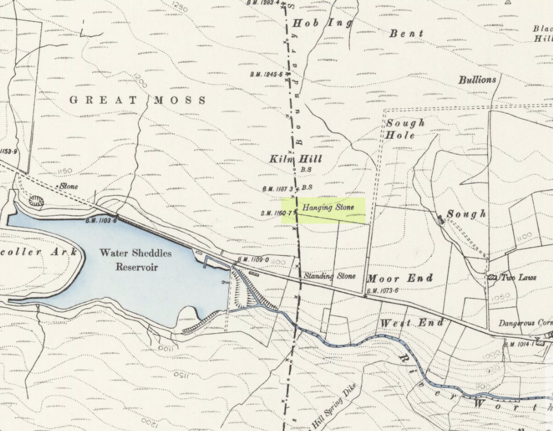
Pretty easy to find. Go along the Oakworth-Wycoller road, between Keighley and Colne, high up on the moors. When you get to the Water Sheddles Reservoir right by the roadside (y’ can’t miss it), stop! On the other side of the road walk onto the moor, heading for the walling a coupla hundred yards to your east (right). Where the corner edge of the walling ends, your standing stone is right in front of you! If for some reason you can’t see it, wander about – though beware the very boggy ground all round here.
Archaeology & History
This seven-foot tall monolith, leaning to one side thanks to the regularly water-logged peat beneath its feet, stands on the Yorkshire-Lancashire. It is locally known as the Hanging Stone and the Standing Stone, but the name ‘Water Sheddles’ is a bittova puzzle. The place-names authority, A.H. Smith (1961) thinks it may derive from the middle-english word, shadel, being a ‘parting of the waters’ – which is pretty good in terms of its position in the landscape and the boggy situation around it. But ‘sheddle’ was also a well-used local dialect word, though it had several meanings and it’s difficult to say whether any of them would apply to this old stone. Invariably relating to pedlars, swindling or dodgy dealings, it was also used to mean a singer, or someone who rang bells, or a schedule, aswell as to shuffle when walking. Perhaps one or more of these meanings tells of events that might have secretly have been done here by local people, but no records say as such — so for the time being I’ll stick with Mr Smith’s interpretation of the word! Up until the year 1618 it was known simply as just a ‘standing stone’, when it seems that the words “Hanging Stone or Water Sheddles Cross” were thereafter carved on its west-face, as the photo below shows.
Cross carved on top of the stoneThe old stone, with its names carved for all to see
Whether or not this stone is prehistoric has been open to conjecture from various quarter over the years. Is it not just an old boundary stone, erected in early medieval times? Or perhaps a primitive christian relic? Certainly the stone was referred to as “le Waterschedles crosse”, as well as “crucem”, in an early record describing the boundaries of the parish of Whalley, dating from around the 15th century. This has led some historians to think that the monolith we see today is simply a primitive cross. However, sticking crosses on moortops or along old boundaries tended to be a policy which the Church adopted as a means to ‘convert’ or christianize the more ancient heathen sites. It seems probable in this case that an old wooden cross represented the ‘crucem‘ which the monks described in the early Whalley parish records.
Site marked on 1892 map
This monolith likely predates any christian relic that might once have stood nearby; although the carving of a ‘cross’ on the head of the stone may have supplemented the loss of the earlier wooden one. But it seems likely that this carved ‘cross’ was done at a later date than the description of the ‘crucem‘ in the parish records — probably a couple of centuries later, when a boundary dispute was opened, in 1614, about a query on the precise whereabouts of the Yorkshire-Lancashire boundary. After several years, as John Thornhill (1989) wrote,
“the matter was resolved on the grounds that the vast Lancastrian parish of Whalley had claimed territorial jurisdiction as far east as the Hanging Stone, thus the county boundary was fixed on the Watersheddles Cross.”
Water Sheddles stone looking SW
Certainly the stone hasn’t changed in the last hundred years, as we can tell from a description of it by Henry Taylor (1906), who said:
“The remains consist of a rough block of stone, leaning at an angle of about forty-five degrees against a projecting rock. The top end has been shaped into the form of an octagon, on the face of which a raised cross is to be seen. The stone is about six feet long and two feet wide, tapering to eleven inches square at the upper end, and appears once to have stood upright. Some local authorities have cut on it the words, ‘Hanging Stone or Waterscheddles Cross.'”
So is it an authentic prehistoric standing stone? Tis hard to say for certain I’m afraid. It seems probable – but perhaps no more probable than the smaller Great Moss Standing Stone found just a couple of hundred yards away in the heather to the west, on the Lancashire side of the boundary. Tis a lovely bitta moorland though, with a host of lost folktales and forgotten archaeologies…