Fingal’s Stone, Killin, Perthshire

Standing Stone:  OS Grid Reference – NN 5712 3301

Also Known as:

  1. Canmore ID 24192

Getting Here

Fingal’s Stone, Killin

Less than 100 yards up the road from the Co-op in Killin, take the footpath on the same side of the road into the park at the back of the buildings. Keep following the footpath round the back of the buildings and you’ll see the stone in front of you soon enough.

Archaeology & History

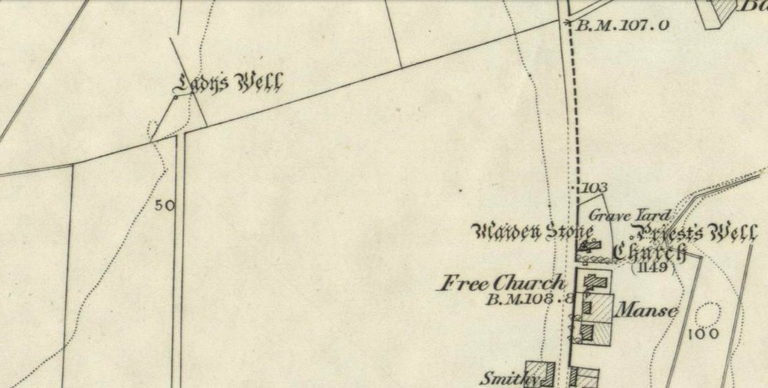
Another curious site in this quite beautiful mountainous arena.  Thought to have originally stood by the rounded fairy knoll a bit further up the hill, no one knows for sure when the stone was moved to its present position—but locals will tell you how the curious knob-end atop of the stone was also a later addition to the fallen original, when it was resurrected in the latter half of the 19th century.  C.G. Cash (1912) also found the fairy mound and its companions on the slope above to be of interesting, wondering, as I have, that “they might have been burial mounds.” The local historian William Gillies (1938) said of the stone:

“Both the Old and New Statistical Accounts of the parish of Killin make reference to a site near the village that had been pointed out from time immemorial as the burial place of Fingal, the hero of Celtic folk stories. At this point, which is in the middle of a field immediately behind the schoolhouse, there is a standing stone 2 feet 8 inches high and 5 feet in girth.  The stone had fallen, but in 1889 it was re-erected by Mr Malcolm Fergusson, a patriotic native of Breadalbane.  Without any reference to the original arrangement, a smaller stone was fixed on the top, and others were placed near it. The lands in the vicinity of Fingal’s Stone used to be called Stix.  The name suggests that here, as at Stix between Kenmore and Aberfeldy, there were a number of standing stones, of which this one alone remains.”

And it certainly smells that way… Yet no further monoliths have been found hereby or on the slopes above.

Folklore

Reputed to be a stone that marks the grave of the hero-figure, Fionn.  Local historian  Duncan Fraser (1973) told that:

“Killin is steeped in history and one of its memorials of the past is a standing stone in a field behind the school, that is said to mark the spot where the mighty Fionn lies buried.  He is believed to have died about the end of the Iron Age, in 283 AD.”

Gazing N, to the Cailleach

William Gillies (1938) also reported how tradition said that an early church and graveyard was once to be found at the original site of Fingal’s Stone. Legends of Finn, his magick and his encounters with both faerie and men are found all over the landscape in this neck o’ the woods….

References:

  1. Cash, C.G., “Archaeological Gleanings from Killin,” in Proceedings of the Society of Antiquaries of Scotland, volume 46, 1911-12.
  2. Fraser, Duncan, Highland Perthshire, Standard Press: Montrose 1973.
  3. Gillies, William A., In Famed Breadalbane, Munro Press: Perth 1938.
  4. Wheater, Hilary, Killin to Glencoe, Appin Publications: Aberfeldy 1982.

© Paul Bennett, The Northern Antiquarian


Lady’s Well, Tullibody, Clackmannanshire

Holy Well:  OS Grid Reference – NS 8563 9548

Archaeology & History

Lady Well on 1866 map

My initial thoughts about this holy well, was that it had been destroyed—but thankfully I was wrong.  It had been intruded upon by roadworks along the B9140, with the original water source affected, but it was re-routed and can still be found below the south-side of the main road.  It was highlighted on the 1866 Ordnance Survey map of the area When the Royal Commission (1933) lads visited the site in 1927 they told that,

“It has no features of special interest. It is 4′ in diameter, but is so much filled up with stones and debris that it is now not more than 2′ deep.”

The site was mentioned in Ruth & Frank Morris’ (1982) survey, but with no additional information. I’ve not been able to find out whether the ‘lady’ of this well was a saintly woman of religious importance, or just one of us commoners!  Does anyone know?

References:

  1. Morris, Ruth & Frank, Scottish Healing Wells, Alethea Press: Sandy 1982.
  2. Royal Commission on the Ancient & Historical Monuments, Scotland, Inventory of Monuments and Constructions in the Counties of Fife, Kinross and Clackmannan, HMSO: Edinburgh 1933.

© Paul Bennett, The Northern Antiquarian


East Riddlesden Cross, Keighley, West Yorkshire

Cross:  OS Grid Reference – SE 079 421

Archaeology & History

A little-known early christian relic found in the driveway to East Riddlesden Hall was saved and propped up in the stable floor at the back.  In 1984 however, the National Trust got round to moving it and bringing the relic to greater public attention by putting it on display in the great hall of the building. (I think you’ve gotta pay to go in and see the stone these days – which is a bittova pain if you just want to examine the carving)

Old photo of the carved stone (after Margaret Faull)

Measuring just 1 foot across and 2 feet high and carved on all sides, the design is all too familiar to those of you exploring early christian or late-Celtic art forms.  Executed sometime between the 5th-10th century, on the main face of the cross we have the traditional ‘Celtic’ interlacing, with a bird-figure emerging on or around an early ‘cross’ symbol.  There are a variety of interpretations of this, but none relate to any modern christian mythic structures.  Indeed, we should cautiously reflect on the more pre-christian nature of this design: carved as it was at a time when the spirit of the natural world (animism) was endemic amongst all people.  This carving would in some way reflect such implicit subjectivity, though perhaps have had emergent ideals relevant to the christian cult within it.  However, we should be cautious about this christian idea, despite it being much in vogue by prevailing groups of consensus trance historians.

References:

  1. Faull, Margaret L., “The Display of the Anglo-Saxon Crosses of the Keighley Area,” in Transactions of the Ancient Monuments Society, New Series no.30, 1986.

© Paul Bennett, The Northern Antiquarian


Whooping Cough Stone, Struan, Perthshire

Legendary Rock: OS Grid Reference – NN 816 653

Getting Here

Old photo of the stone (after Duncan Fraser)

Up the A9 past Blair Atholl, a few miles later there’s the turning for Struan.  Scarcely a mile east of old Struan Church, head past the old farmhouse of Old Kindrochat and keep going eastwards along the edge of the trees for about 200 yards until you reach the sheepfold. There you’ll see a singular rock sitting alone by the fence. That’s it!

Archaeology & History

This little known healing stone was, at one time last century, of great repute in the Highlands. Today, very few people even know it exists. One of many rocks that were said to possess healing abilities, this one (obviously) was of great repute in the curing of whooping cough. But it wasn’t the rock alone that did the work here, for upon its edge was a small basin into which rainwater collected and this, when used correctly and in due accord with ancient ritual tradition, could enact the cure.  Mr Duncan Fraser said of this fascinating healing stone:

“The grey water-worn stone is about 4ft 6in long, 2ft 6in broad and 2ft high, with a deep gash on top, where the water lingers even in long dry spells. When full it holds about half-a-gallon. People were still coming here with their sick children as late as 1860 — and bringing a spoon made from the horn of a living cow. There was no cure without that.”

The ritual “spoon made from the horn of a living cow” was an important ingredient at another site with the reputation for curing whooping cough about 50 miles south of here, near Balquhidder. (see Whooping Cough Well, Killin)  What truly fascinates me is the origin of this stone and its medicinal virtues.  When  did the healing rites first start here – how long ago…?

References:

  1. Fraser, Duncan, Highland Perthshire, Standard Press: Montrose 1969.

© Paul Bennett, The Northern Antiquarian


Rivock East Carving, Keighley, West Yorkshire

Cup-Marked Stone: OS Grid Reference – SE 07640 44215

Getting Here

Cupmarks at Rivock East

Take the same directions as if you’re going to Dave’s Stone, to the eastern end of Rivock Edge itself. Then take less than 10 steps further onto the moor itself and you’ll see the stone pretty low down in the heather. (please note that grid-reference above needs revising)

Archaeology & History

…and looking straight down!

Found about 10 yards onto the flat ridge south of Dave’s Stone cup-marked stone, the vegetation covering this carving had only recently been brushed off when we revisited the place in 2012, by members of the Ilkley CSI team in their own survey of the area.  As you can see, it’s a simple design of just two well-preserved cups on a small rounded stone. What may be the remains of a very faint ring arc is possible over one of the two cups. Nowt much more to say really!

© Paul Bennett, The Northern Antiquarian 


Boat Stone, Blackford, Perthshire

Standing Stone (fallen): OS Grid Reference – NN 87202 07286

Getting Here

Fallen monolith in the grass

From Blackford on the north side of the A9, cross over and take the small B-road which quietly runs up and over Sheriffmuir towards Dunblane.  After a mile, keep your eyes keen for the approaching woodland on your right-hand side; for in the field just before the woods, you’ll see a patch of grass near the corner of the field with a long stone poking out of it. That’s it!

Archaeology & History

It seems that very little has been written about this monolith in any of the archaeology texts, but it’s ascribed locally to be a fallen standing stone.  The site’s described in Finlayson’s (2010) fine local megalith guide where he points out how it’s in line with other nearby standing stones at Gleneagles and the White Stone – and the line is damn close!

…and from another angle…

With a quartz vein running through it, the stone lays some thirteen feet long and was, at some time in the not-too-distant past, readied to be quarried, as evidenced by the chisel-marks cut into it, prior to the usual destruction. But this time, for some reason, someone must have come to the rescue and prevented its demise…thankfully…

The farmer annually cuts around the fallen stone, shaped like a long boat (hence the name), near the top corner of the field. It would have looked damn good when stood upright, standing about ten feet in height and visible for a good distance. But today it’s quite forlorn laid here, seemingly alone, in this quiet part of the country, and is probably only one of interest to hardcore megalithomaniacs amongst you!

References:

  1. Finlayson, Andrew, The Stones of Strathearn, One Tree Island: Comrie 2010.

© Paul Bennett, The Northern Antiquarian


Castle Hill, Culross, Fife

Hillfort: OS Grid Reference – NS 97105 89923

Getting Here

A gorgeous setting, in the trees

Take the A907 road between Clackmannan and Comrie and, close to Bogside Farm at the roadside, but on the other side of the road where the bridge crosses a burn, take the dirt-track uphill and into the woodland. About 300 yards up (before you hit the signs pointing you to the farm) , walk uphill into the trees on your left until the ground levels out. Look around! (and best visited between December and May, before the bracken covers the place)

Archaeology & History

Visiting this site is pleasure in itself. Situated in an open forest, with traditional pine trees in abundance, there are scattered amidst the edges of this large oval-shaped Iron Age structure, the aged boughs of ash and beech, centuries old, along its edges and throughout the woods. It is a truly superb setting! When visited by the Royal Commission lads in April, 1925, they found the remains here in good condition. A few years later in their impressive Inventory, they told:

“In Castlehill Wood, about 250 yards to the southwest of Bogside Railway Station, and at an elevation of 200 feet above sea-level, is a small plateau of very regular oval form with its major axis northwest and southeast. It is surrounded by a single ditch, the well-marked enclosure thus produced having a maximum measurement of 185 by 135 feet. At the southeast the ditch has been left uncut in order to provide a passage for entrance. This passage has been about 20 feet wide, and at its inner end there are on either side faint traces of a low mound, which in all probability once ran right round the edge of the enclosure and which may have been palisaded.”

RCHAMS 1933 plan of site

Sadly when I came here a few days ago, much of the was very overgrown with bracken and other vegetation, making it impossible to see the site properly and preventing any decent photos. We’ll go back here in a few months time to get better images!

Folklore

This site was mentioned, albeit briefly, in David Beveridge’s (1885) magnum opus on the history of Culross.  With equal brevity he noted several standing stones in the region, saying how tradition afforded them a Danish origin.  This site was the same for

“a tradition prevails that after the battle of Inverkeithing the Danish army or a portion of it retreated to a station in the north of Culross parish, where they erected the earthwork or camp of Castlehill, still existing near the Burrowine Farm.”

References:

  1. Beveridge, David, Culross and Tulliallan: Its History and Antiquities – volume 1, William Blackwood: Edinburgh 1885.
  2. Royal Commission on the Ancient & Historical Monuments, Scotland, Inventory of Monuments and Constructions in the Counties of Fife, Kinross and Clackmannan, HMSO: Edinburgh 1933.

© Paul Bennett, The Northern Antiquarian


Idol Rock, Ilkley Moor, West Yorkshire

‘Cup-Marked’ Stone:  OS Grid Reference – SE 13296 45898

Also Known as:

  1. Carving no.221 (Hedges)
  2. Carving no.327 (Boughey & Vickerman)

Getting Here

Idol Rock, Ilkley Moor

From Cow & Calf Hotel head onto the moor above you, following the same directions to reach the ornately carved Idol Stone (and its immediate companions). Ahead of you on the same footpath, about 100 yards along, as it begins to slope up the hill further onto the moor, you’ll see a large upright pyramid-shaped stone, about 8 feet all, right at the side of the path. Y’ can’t miss it!

Archaeology & History

Deep cups & lines on top

Although ascribed as a cup-marked stone in usual surveys, the cup-markings on top of this rock are seemingly Nature’s handiwork. There is a possibility that cup-markings were carved into the top of the stone, many thousands of years ago, but due to the centuries of wind and weathering, we cannot in anyway assess the curvaceous bowls and lines running across and from the top of this rock to be artificial.

Folklore

The name ‘Idol Stone’ seems to have come about as a result of the judaeo-christian Victorian obsession of satanic idolatry in all things natural – which many of them still fear. Sadly there are no early accounts of practices of idolatry at this rock, until it was used by chaos magickians in the formative years of that Current in the 1980s.

References:

  1. Bennett, Paul, The Old Stones of Elmet, Capall Bann: Milverton 2001.
  2. Boughey, K.J.S. & Vickerman, E.A., Prehistoric Rock Art of the West Riding, WYAS: Leeds 2003.
  3. Cudworth, William, “Rombald’s Moor Antiquities,” in Bradford Scientific Journal, volume 3, 1912.
  4. Forrest, C. & Grainge, William, A Ramble on Rumbald’s Moor, among the Dwellings, Cairns and Circles of the Ancient Britons, W.T. Lamb: Wakefield 1868-9.
  5. Hedges, John (ed), The Carved Rocks on Rombald’s Moor, WYMCC: Wakefield 1986.
  6. Holmes, J., “A Sketch of the Prehistoric Remains of Rombald’s Moor,” in Proceedings of the Yorkshire Geological Society, volume 9, 1887.
  7. Speight, Harry, Upper Wharfedale, Elliott Stock: London 1900.

© Paul Bennett, The Northern Antiquarian 


Borough Hills necropolis, West Mersea, Essex

Tumuli (destroyed): OS Grid Reference – TM 022 143

Also Known as:

  1. Barrow Hills
  2. Five Barrows

Archaeology & History

Known as Five Barrows presumably from the five main burial mounds that were once here, very little in modern texts seem to describe them.  In the grid-reference given above, I’m not 100% certain that this is the correct spot – and as many of them have been destroyed, we’ll stick to this until someone tells us otherwise! (it is only Essex anyway)

The ‘barrow’ site that remains has been ascribed as Romano-British in date, whilst the others don’t seem to get a modern mention.  These missing barrows were described in a short article in The Gentleman’s Magazine by a Mr J.A. Repton (1840), who told the following:

“In reading an account of Essex, I find the following Borough, or rather Barrow Hills, on the north side of the Black Water Bay, were considerable in number. These tumuli are supposed to have been raised indiscriminately over the bodies of the Danes and Saxons that fell in the battles occasioned by the frequent landing of the former in this part of the coast. The lands on which the barrow hills stood were completely inclosed from the sea in 1807, and the whole are now levelled, one excepted.

“This barrow I heard was going to be cleared away for manure. I made a point of visiting it under an idea that it might be proved a Roman one; when I arrived at the spot, I found it to be a bowl barrow, about 14 yards diameter, and about 6 or 7 feet high, and rather more than half of it cut away, and what surprises me, not a single urn, bone, or ashes, nor any mark to be found; perhaps the barrows being mostly under water during the tide may account for the disappearance of bones, etc., if there ever were any placed; or rather that the Danes and Saxons were not so careful as the Romans in preserving the remains of their friends. I met one of the old inhabitants who lived in the parish more than forty years; he remembered the number of barrows being destroyed, and said not a single bone or urn was ever found in them.

“Perhaps you can give me some information, whether by digging below the natural surface of the ground, any remains may be traced. It is not a gravelled, but a clean, light clay soil. The land is low and marshy, and celebrated for Maiden salt, and near it there is a decoy. ”

If anyone has further information about the other barrows which are described in several old early accounts, it’d be good to know!

Folklore

Archaeologist and folklorist Leslie Grinsell (1976) noted briefly that the barrows here supposedly covered the remains of Danes who died in battle here.

References:

  1. Grinsell, Leslie V., Folklore of Prehistoric Sites, David & Charles: London 1976.
  2. Repton, J.A., “Borough Hills, Essex,” in The Gentleman’s Magazine, 1840 (part 2, p.114).

© Paul Bennett, The Northern Antiquarian 


Sauchie, St. Ninians, Stirling, Stirlingshire

Cairn (destroyed): OS Grid Reference – NS 77 88

Archaeology & History

An impressive prehistoric cairn of some considerable size was in evidence on the lands of Old Sauchie, near Sauchie farmhouse, until the Industrial Age brought an end to its presence. First mentioned in the New Statistical Account (‘Stirlingshire’, volume 7), the Royal Commission lads reported,

“Nothing now remains of the cairn that once existed ‘on the lands of Sauchie’, about 3 miles SSW of Stirling. It was examined in the early 19th century and is said to have measured more than 20ft in height and 90ft in diameter, to have been made of stones, and to have contained two cists, one somewhat larger than the other. It is possible that Wilson (1863) is referring to this cairn when he mentions a quantity of ‘silver coins recently found in a cist exposed on the demolition of a cairn on the lands of Sauchie.’ The coins were very thin, and were described as having been ‘struck through from the back,’ with ‘figures’ on one side only. Some of them had loops for suspension, and there can be little doubt that they were silver bracteates. All have been dispersed and lost.”

If anyone has further information about this obviously important and seemingly lost site, please let us know!

References:

  1. Royal Commission on the Ancient & Historical Monuments, Scotland, Stirlingshire – volume 1, HMSO: Edinburgh 1963.
  2. Wilson, Daniel, The Archaeology and Prehistoric Annals of Scotland – volume 2, Sutherland & Knox: Edinburgh 1863.

© Paul Bennett, The Northern Antiquarian