Ancestors’ Stone, Low Snowden, Askwith, North Yorkshire

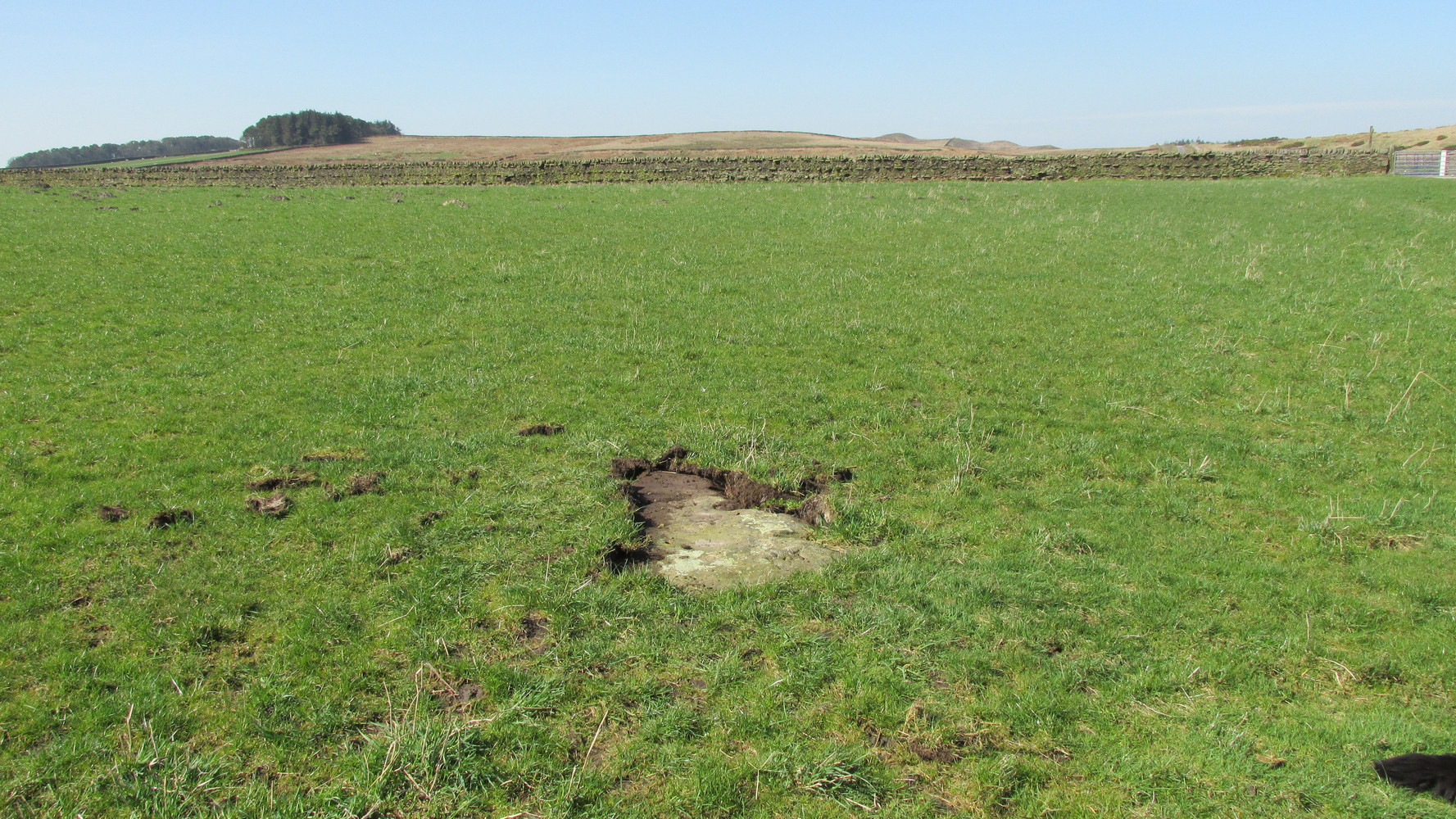
Cup-and-Ring Stone:  OS Grid-Reference – SE 18083 51229

Also Known as:

  1. Carving no.606 (Boughey & Vickerman)
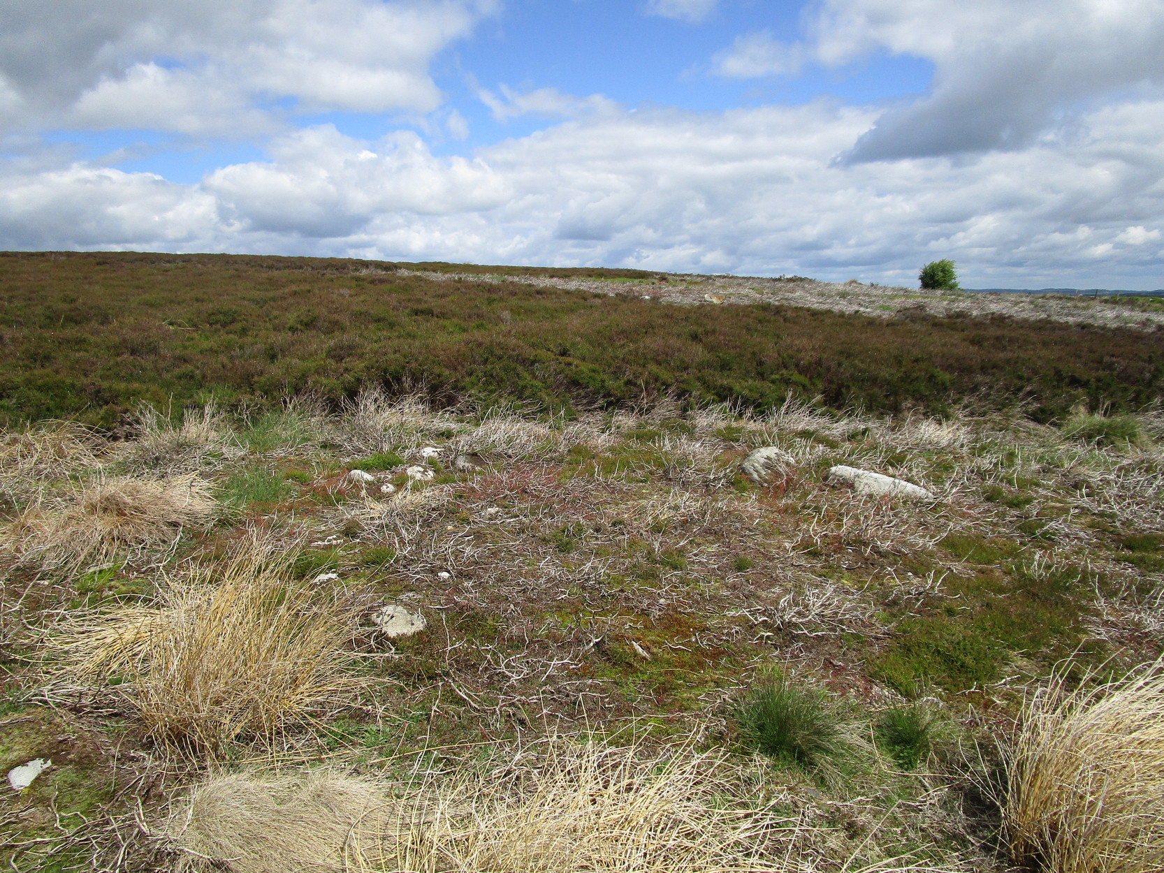
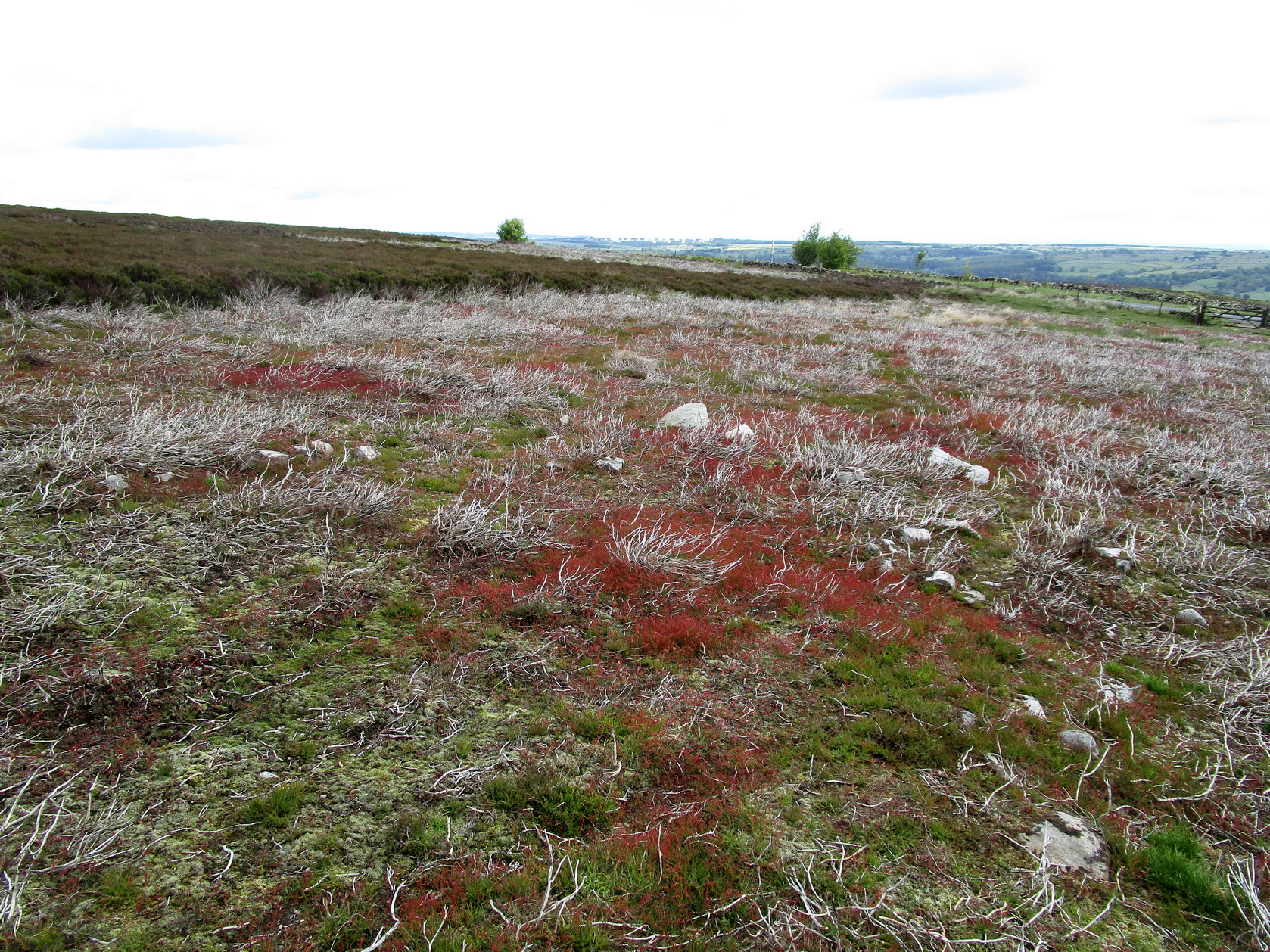
Getting Here

The Ancestors Stone

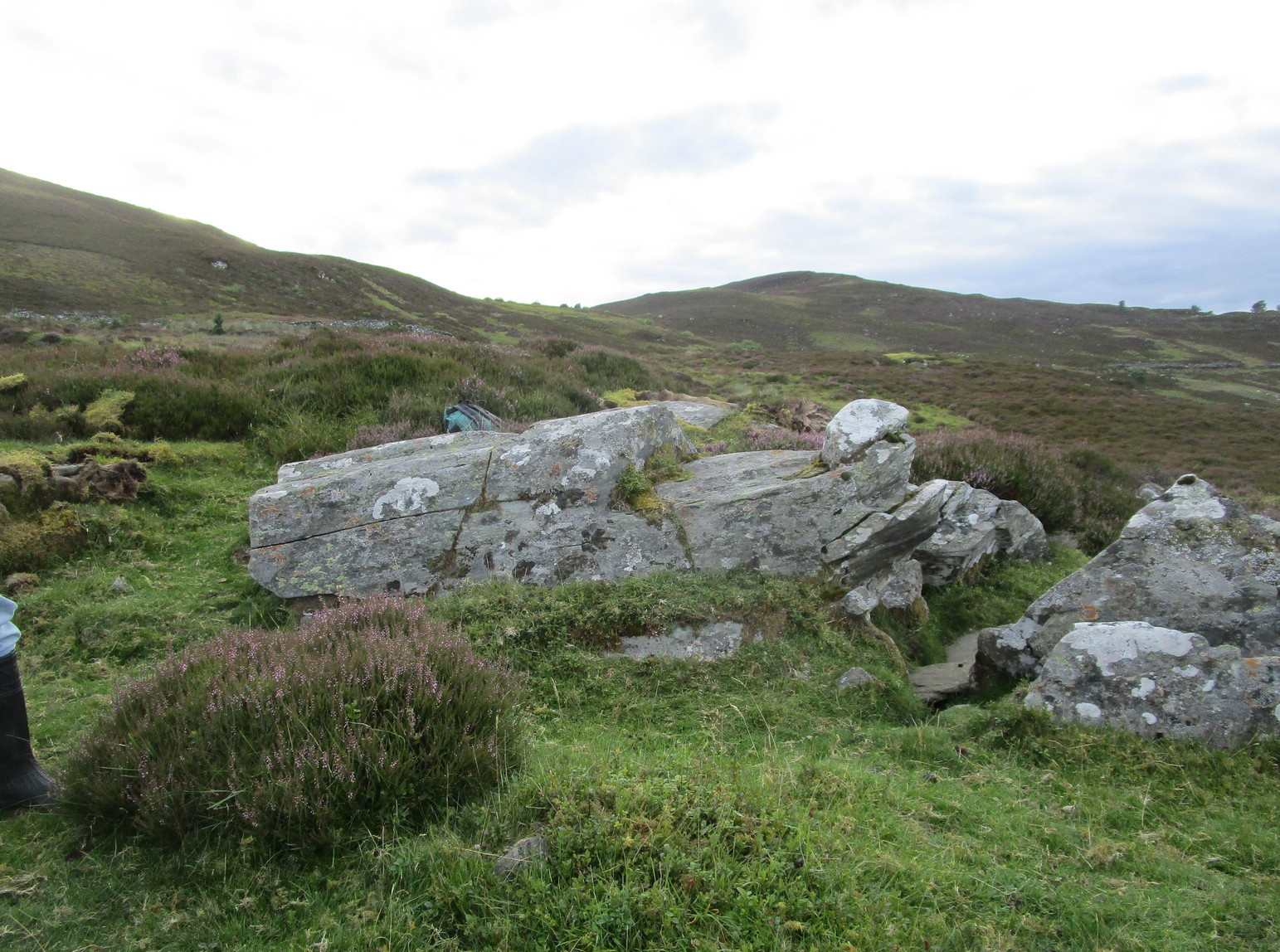
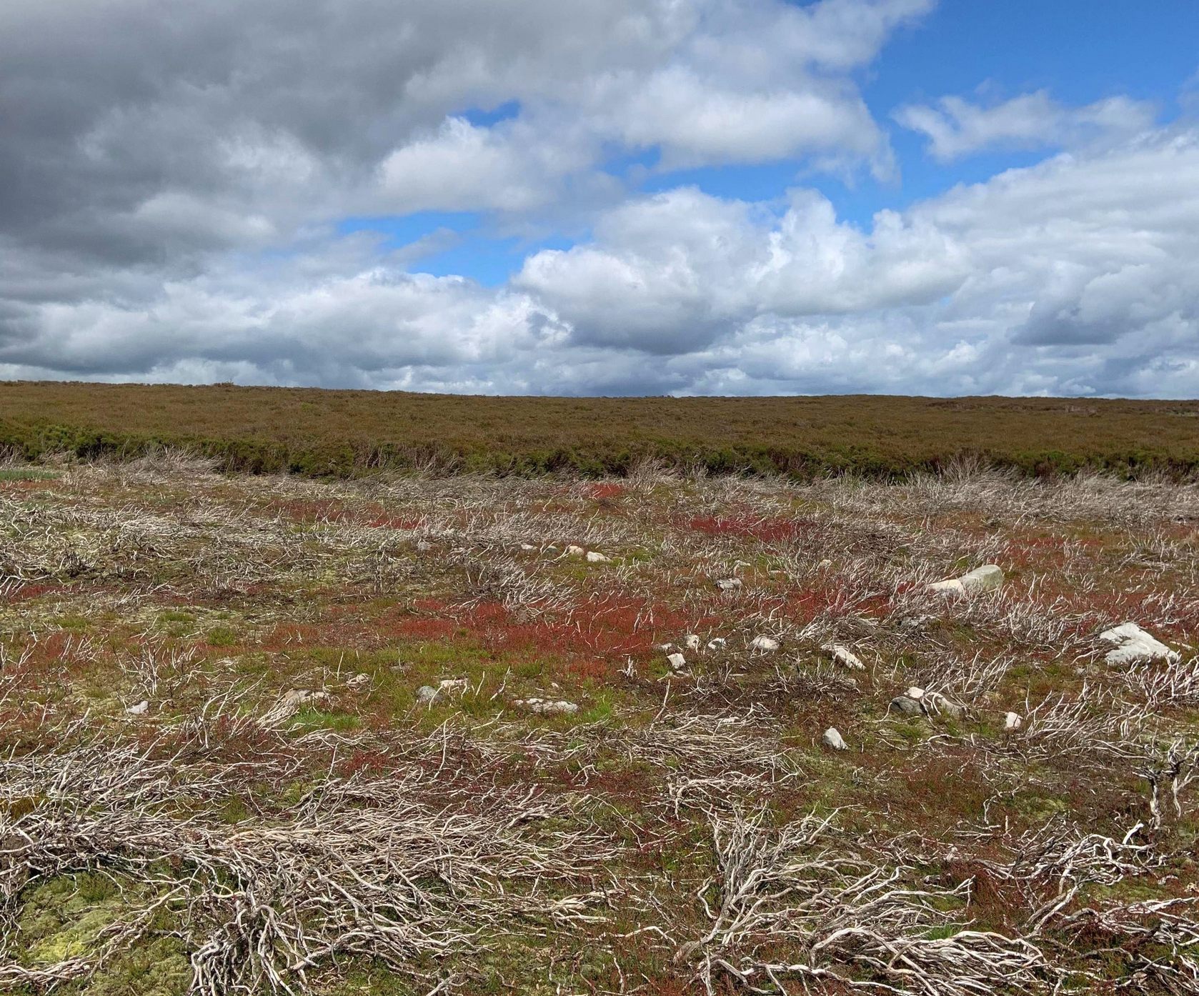
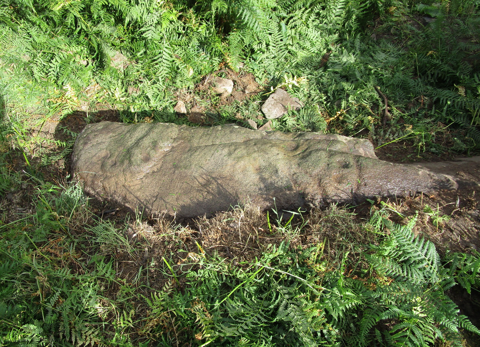
If you’re coming up from Otley or Askwith, take the same directions as if you’re going to visit the impressive Naked Jogger Carving (stone 612), not far from the well-known Tree of Life Stone.  From the Naked Jogger carving, walk up to the small outcrop of rocks that bends above you.  There’s a small collapsed line of walling just behind the outcrop.  Walk along this up the slope as if you’re heading for the Sunrise Stone carving, but only 30 yards along, low down and right into the edge of the wall itself, you’ll see this elongated piece of stone.  That’s the spot!

Archaeology & History

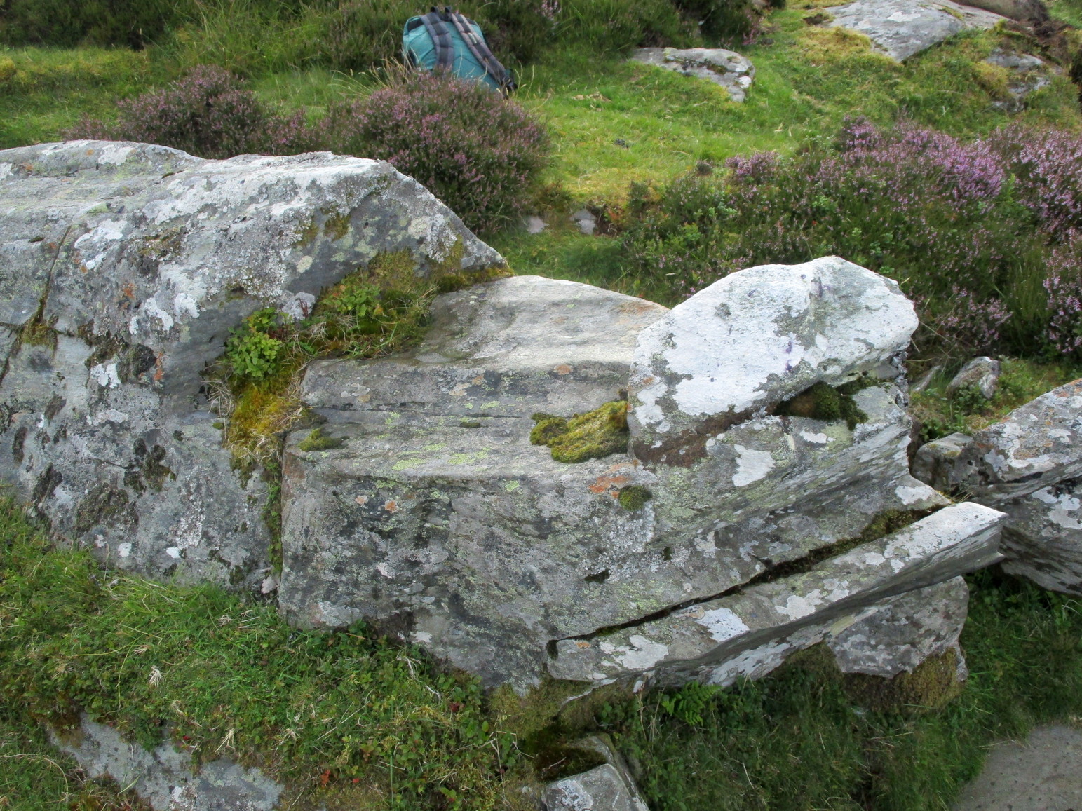
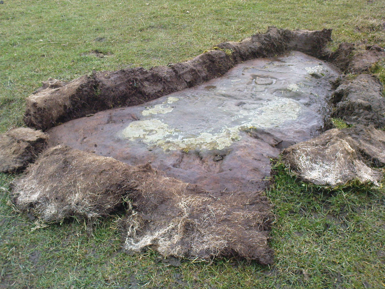
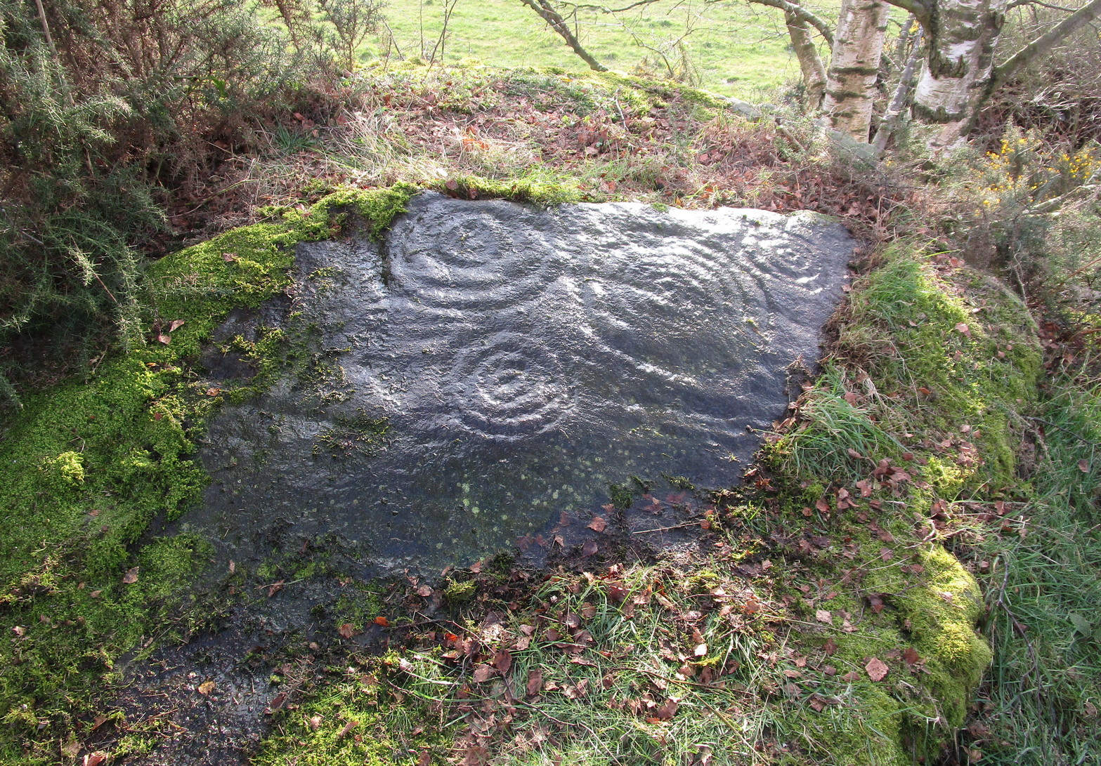
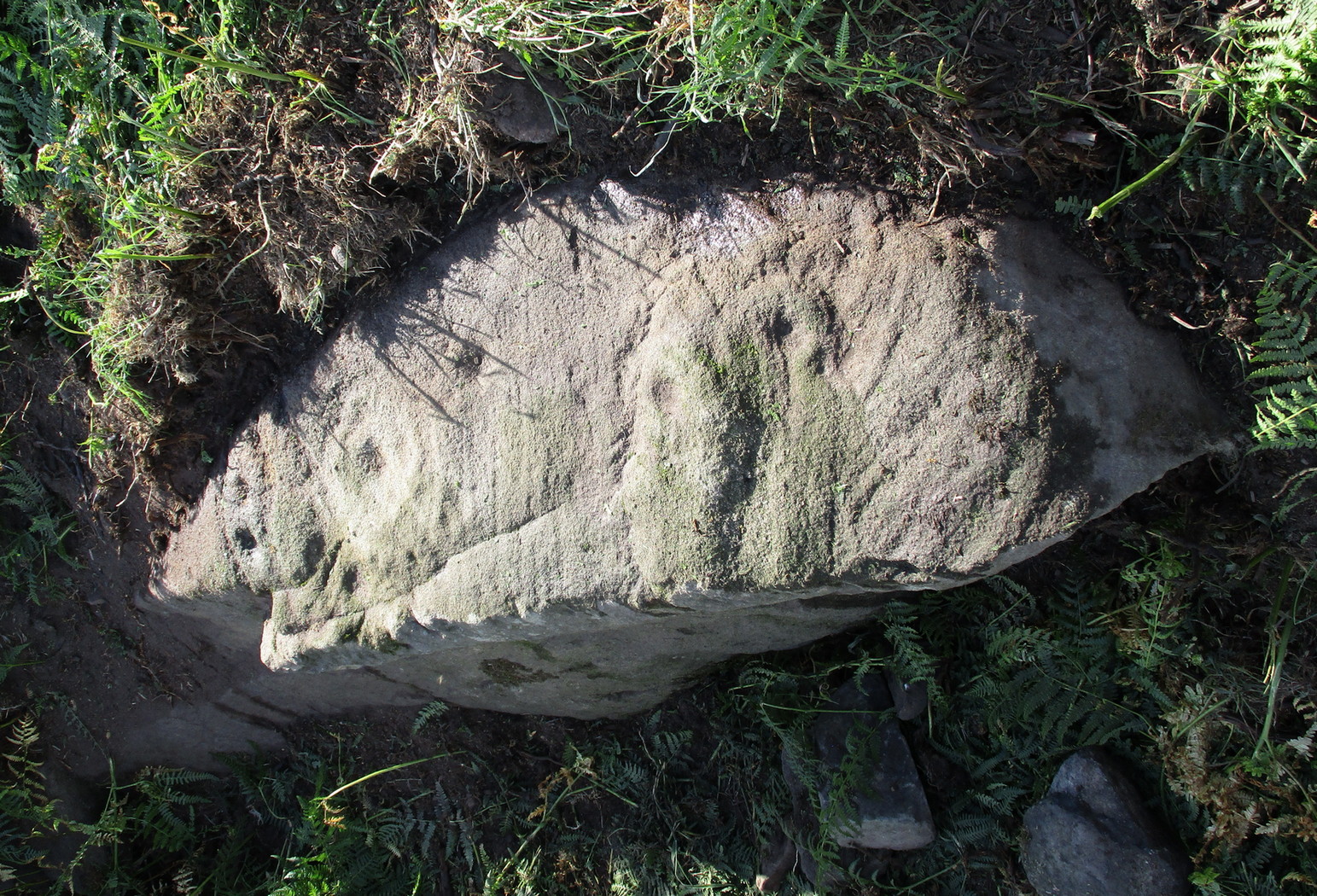
If you’ve caught the petroglyph-bug, you’ll like this one!  It received its name from the curious fusion of natural cracks with the man-made pecked lines that shows, quite distinctly when the light is right and the stone is wet, the outline of two humanesque forms joined to each other.  Figurative rock engravings of ancestors in the UK are extremely rare and when we came across this example, we noticed how the design could be interpreted as two Askwith Moor ancestor figures. Figurative rock art images elsewhere in the world such as the magnificent Wandjina paintings and the extensive galleries of figures engraved at Murujuga (Burrup Peninsula) in Western Australia, might provide an initial comparison, though more specific work needs to be done to better understand this unique petroglyph.

Sketch of the carving

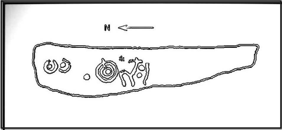
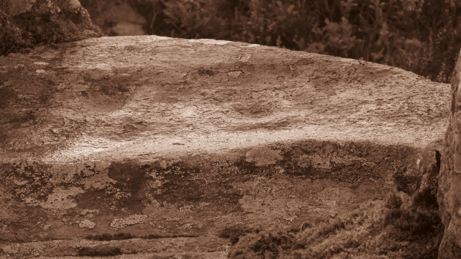
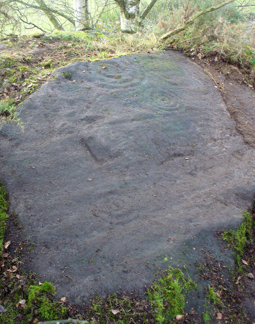
You can almost make out the figures in the above photo: the upper torsos of two beings on the right-hand side of the rock, almost fused together.  And the carved shapes of these “ancestral beings” are morphically similar to some elements in the Sunrise Stone just 50 yards away – which themselves remind me of a Northumbrian carving near Doddington known as West Horton 1a. (Beckensall 1991)  But we should’t get too carried away by the idea because—as we can see here in the sketch of the carving—when looked at from a different angle above, we could infer the right-hand carved elements to be representative of an animal: a deer, perhaps.  Rorscharch’s once more tickle the exploring mind….

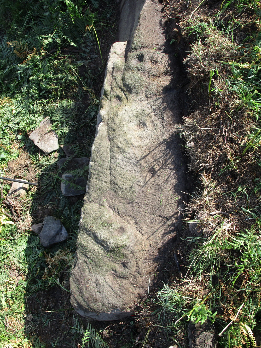
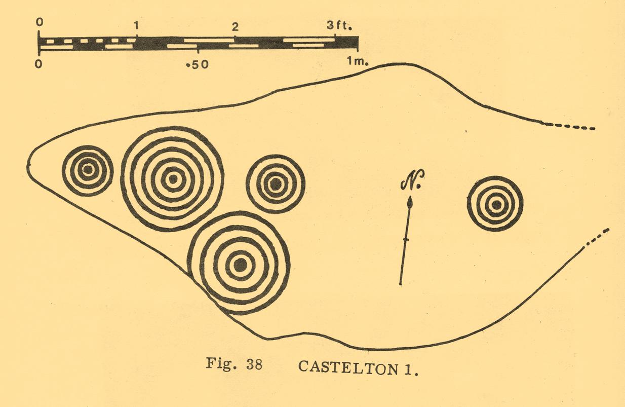
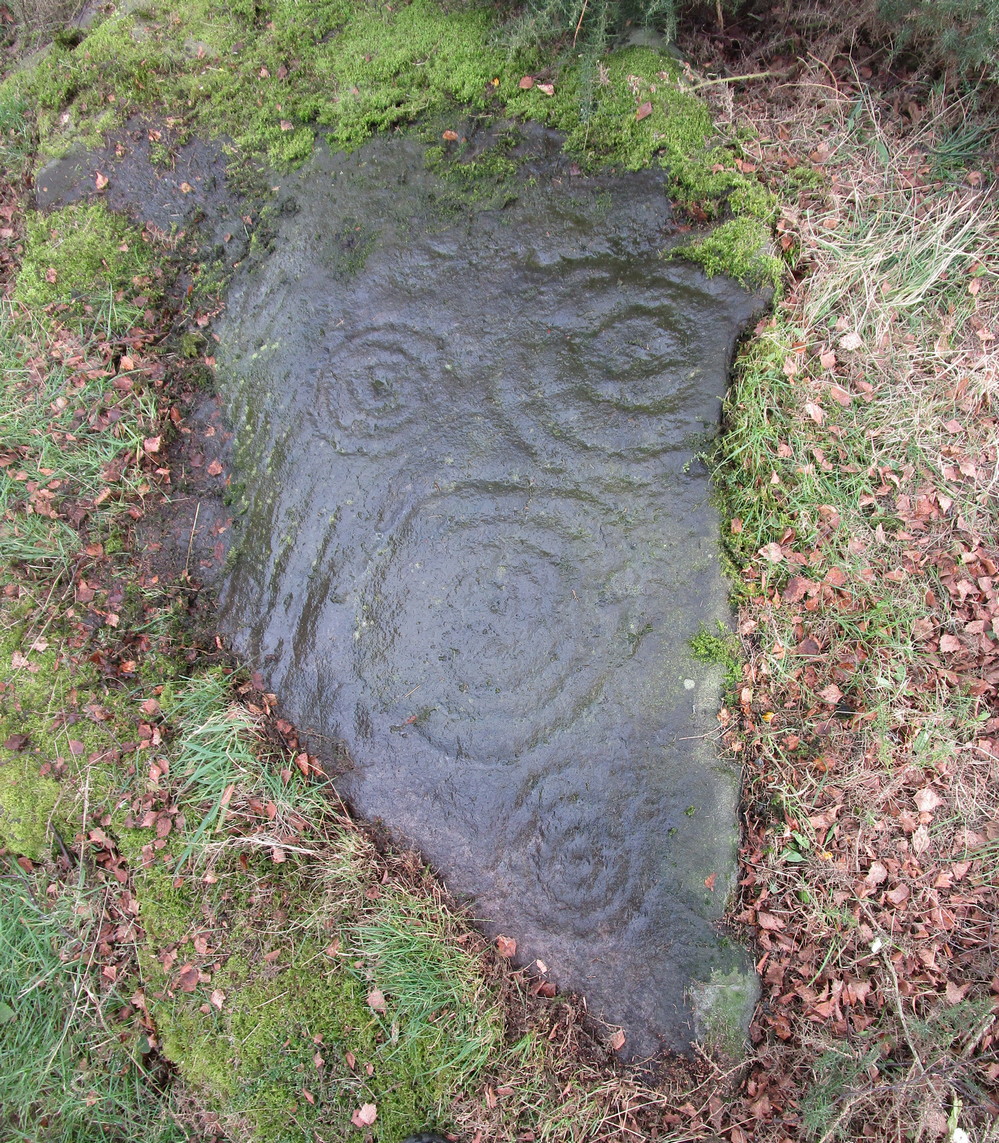
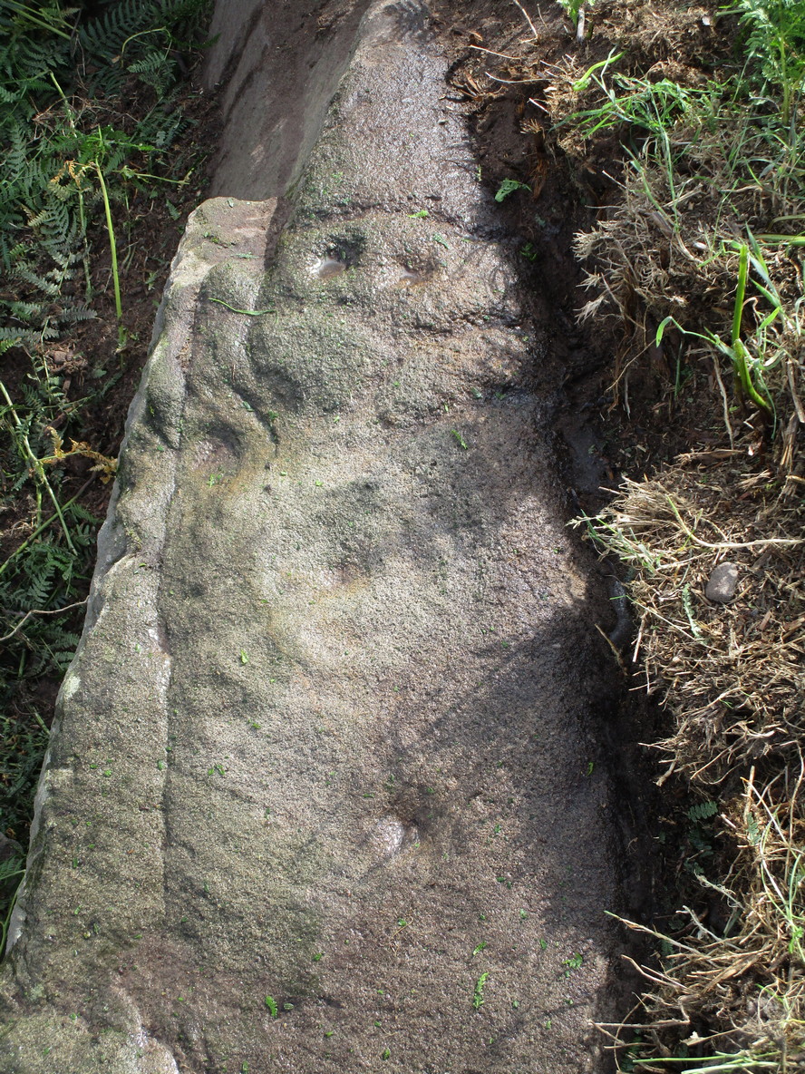
The rock has been quarried into at same time in the past (just like the nearby Sunrise Stone), leaving us to wonder what the complete carving might have looked like.  No doubt some pieces of it will be in the collapsed walling either side of the stone.  All we have left to see are the two unfinished cup-and-rings above the natural cracks that give rise to the “ancestral being” appearance.  The faint double cup-and-ring has curious linear arcs to its side, with two well-defined cups enclosed by two of them.  It’s a nice-looking carving when the light is good.  The petroglyph was carved over a long period of time, as evidenced by the differing levels of erosion in different sections of the design.  It’s a common attribute.  The oldest section is the faint double cup-and-ring, whose mythic nature was added to / developed at a much later date, perhaps even centuries later.

In the always-expressive archaeocentric description of Boughey & Vickerman’s (2003) otherwise valuable tome, they told this carving to be,

“Long, narrow, thick rock of medium grit. Six cups, one with a double ring with a tab out and two with at least partial single rings, grooves.”

Evocative stuff!

It’s very likely that this carving had some mythic relationship with its close neighbours either side of it, probably over a very long time period and I’m inclined to think it somehow related to the rising of the sun, just like its solar companion further up the slope.  Please note how I emphasize this ingredient in the site profile of its neighbour, the Mixing Stone 10-15 yards away—roughly halfway between this and the Sunrise Stone.   A distinct place of ritual was happening in this close-knit cluster of carvings…

References:

  1. Beckensall, Stan, Prehistoric Rock Motifs of Northumberland – volume 1, 1991.
  2. Boughey, Keith & Vickerman, E.A., Prehistoric Rock Art of the West Riding, WYAS: Leeds 2003.
  3. Reeder, Phil, “Snowden Carr Rock Carvings,” in Northern Earth Mysteries, no.40, 1990.

© Paul BennettThe Northern Antiquarian

Pit Marshes, Kilnsea, East Yorkshire

Tumulus (destroyed):  OS Grid-Reference – TA 420 150

Archaeology & History

This long lost site is one of probably many such sites on the east coast of Yorkshire and Lincolnshire that used to exist, before the great North Sea took them away.  The only account I’ve found of this one is from a short article in an early copy of the Lincolnshire Notes & Queries magazine by John Cordeaux (1891), who wrote:

“The Spurn, or Spurn Point, as it is now usually called, at the mouth of the Humber, is so closely connected with Lincolnshire history that it is unnecessary to apologize for recording in Lincs. N. & Q. an interesting sepulchral relic found there.  This is a rude chest or coffin, roughly hewn and squarely hollowed, probably with stone implements, from the trunk of an oak, recently exposed by the action of the sea on the beach at Kilnsea.  The total length overall of the chest is 51 feet, the interior (it was much decayed and fallen when I saw it) little, if anything, over four feet.  In this space the skeleton, presumably of an adult male was found doubled up.  Most unfortunately the original finders (labourers) scattered the bones, which subsequently were washed away. A thigh bone alone being recovered, and this is suggestive of a man probably a little below the average height.

“From oral evidence collected in the neighbourhood, I came to the conclusion that the body must originally have been buried with the head bent forward on the chest, and the legs tucked up like a trussed fowl, the knees near the chin. No corresponding lid or covering was found on the coffin, it had been placed in an excavation in the red or chalky boulder clay, and tenacious blue clay placed on it. The locality on the coast where it was found represents the Pit Marshes — that is before “the sea gat ’em ” — their position was about one-hundred and fifty yards south of the first sea-groin on Kilnsea beach. It is not improbable that a barrow or tumulus, either of earth or piled stones, at one time covered the interment, until levelled and dispersed by the sea’s encroachments on the land. Not far from this place on the beach, a small, simple, flat-sided celt, about four inches long, was picked up. It may or may not have borne some relation to the occupant of the oak coffin. When the foundations of the enlarged Chancel of St. James’ Church, Grimsby, were dug, a similar coffin or chest was exposed, partly within and partly without the line of the north chancel wall. I remember it was conjectured at the time, from the comparatively small interior, that it had been used for the interment of a child.  It is more probable, however, that it had once contained an adult packed away in the manner indicated at Kilnsea.”

A very short distance north we find the place-name of “How Hill”, which may be a record its existence, as the word how in many places round here can mean a tumulus.  Seems to make sense.

References:

  1. Cordeaux, John, “Ancient British Interment,” in Lincolnshire Notes & Queries, volume 2, 1891.

© Paul BennettThe Northern Antiquarian

Witches’ Stone, Horndean, Berwickshire

Standing Stone:  OS Grid Reference – NT 9050 4960

Archaeology & History

The first that I read of this place was in an article of the Scottish Ecclesiastical Society journal, on the parish history of Horndean.  Standing originally at the edge of the ruined remains of the old churchyard, the author W.S. Moodie (1915), told that a long lost,

“grim relic of olden days is said to have existed here till fifty years ago.  This was the Witches Stone—an upright pillar with a hole in it, to which the bodies of the poor unfortunates were fastened after they had been glede, while the faggots were piled around.”

A perusal in the Royal Commission inventory (1915) of the same year told that it had been moved several miles northeast to Paxton Cottage (NT 9279 5229) in the adjacent village.  It was described as being,

“about 4 feet 6 inches in height above the ground, some 2 feet in breadth, tapering towards the upper end, and about 7 inches thick.  Near the top are two perforations, not quite on the same level, about 2 inches in diameter at the surface on either side, constricted towards the Centre, and about 9 inches distant from centre to centre.”

Is this old stone still in existence…?

References:

  1. Moodie, W. Steven, “Ladykirk, or the Kirk of Steill, Berwickshire,” in Transactions of the Scottish Ecclesiological Society, 4:3, Aberdeen 1915.
  2. Royal Commission Ancient & Historical Monuments, Scotland, Inventory of Monuments and Constructions in the County of Berwick, HMSO: Edinburgh 1915.

© Paul BennettThe Northern Antiquarian

Craig Hill cluster (4), Kenmore, Perthshire

Cup-and-Ring Stone:  OS Grid Reference – NN 81303 44419

Getting Here

Craig Hill cluster (4) stone

From Kenmore go east up the steep mountain road towards Glen Quaich, or if you’re coming from Amulree, go west along the same glen.  After 2½ miles (4km) up the Kenmore route (nearly 9 miles on the Amulree route) you’ll reach a small lochan on your left (you’ve got a very small parking spot a coupla hundred yards before the loch).  A gate and stile past the loch takes you east along a track into the moors.  More than a mile on, the track splits, but you need to keep to the left and follow the track along the wall-side for another 400 yards or so, where you’ll see a small crag of rocks 100 yards down the slope on your right. Once here, the elongated rock with a “seat” that you can sit in is the stone in question.

Archaeology & History

At first sight this stone doesn’t seem to have anything petroglyphic about it, and—as when we visited the other carvings in this Craig Hill cluster—the weather was grey and overcast, so it was difficult to discern anything at first.  But as we walked round and round inspecting the Craig Hill cluster-5 carving, a glance at this adjacent stone seemed to indicate one or two cup-marks within the curious chair-like aspect of the rock, but we couldn’t initially work out whether they were simple geophysical elements or not.

Very faint cup-&-half ring near the centre
Close-up of the C&R

So we poured water onto the stone in the hope that something might show up.  And the more we walked round and round, bending down, looking from as many angles as possible, not only did we see what looked like several cups, but one of them had a half-ring that curved round what may or may not be a natural cupmark.   You can see it pretty clearly in the attached photos.  In other photos that we took, the faint cup-and-half-ring seems to plays its part in a line of three or four other cups; although in order to ascertain whether these elements are man-made or not, we could do with the help of a good geomorphologist.

Acknowledgements:  Huge thanks to Prof Paul Hornby for use of his photos in this site profile; and to Myrna Hurley for getting us up there.  Cheers doods. 😉

© Paul BennettThe Northern Antiquarian

Town Cross, Kendal, Westmorland

Cross (destroyed):  OS Grid reference – SD 5152 9280

Also Known as:

  1. Cold Stone
  2. Market Cross

Archaeology & History

Not to be confused with the carved cross fragments held in the local church, this old town cross has long since gone.  It’s existence was recorded by the great Kendal historian Cornelius Nicholson (1861), but even in his day, this “obstruction” as he called it, was no longer standing.  Known as the local Market Cross where all the wheeling and dealing took place—official ones, as well as the not-so-official works of local folks—it stood just off Stricklandgate,

“opposite the Covered Market, and was an obstruction in the street.  There still remains a remnant of it in a stone at the corner, vulgarly called “cold stone,” where the charters and so forth were usually proclaimed.  Cold stone is a corruption of “call stone;” an appendage common to most ancient towns, where all public matters were “called” prior to the “institution” of belman.”

This folk etymology of “cold” needs to kept in mind when we come across other stones of this name.  …The earliest record of a market held at Kendal is from 1402, but written records of the Market Cross are scant until 1714. Such edifices tend to be architecturally ornate, but we have neither sketches nor descriptions of this lost site and must await the work of fellow researchers who may hopefully find out more.

References:

  1. Nicholson, Cornelius, The Annals of Kendal, Whitaker & Co.: London 1861.
  2. Smith, A.H., The Place-Names of Westmorland – volume 1, Cambridge University Press 1967.

© Paul BennettThe Northern Antiquarian

Glenballoch, Blairgowrie, Perthshire

Cup-Marked Stone (lost):  OS Grid Reference – NO 186 480

Archaeology & History

When J. Romilly Allen (1881) wrote about the megaliths and petroglyphs of Glenballoch, the owner of the property—a Mr George Harris—informed him of other archaeological finds in the locale: one of which was a cup-marked stone with distinct linear elements, whose description reminded me, slightly, of Ilkley’s Idol Stone.  It was found a short distance east of the Glenballoch (or Craighall Mill) stone circle.  Allen told how,

“Mr Harris…informed me that about twenty years ago he had dug up a stone with cup-markings upon it, on the opposite side of the valley to the south-east of the Glenballoch stone.  The stone lay horizontally with the cups uppermost.  It was split up and is now built into the out buildings of Glenballoch Farm.  The two largest fragments form the cover and sill of the hole through which the shaft of the threshing machine passes through the wall of the horse-mill, into the house.  A third fragment is built in above the window at the opposite side of the house, and is of greenish hue. Mr Harris expressed his great regret at not having known the value of this stone when he broke it up, and he is evidently proud of the stone which remains, and is determined that no ill shall befall it as long as he remains its guardian.  The cup marks on the stone which was broken appear to have been arranged symmetrically in two rows, and Mr Harris affirms distinctly that they were alternately circular and rectangular.”

These three stone fragments have not been seen since.  They may still be covered over in the spot Mr Harris described, but no one seems to have found them.  In the event that someone manages to find them, see if you can get a few good photos and stick ’em on our Facebook group.

References:

  1. Allen, J. Romilly, “Notice of Three Cup-Marked Stones, and the Discovery of an Urn, in Perthshire,” in Proceedings of the Society of Antiquaries Scotland, volume 15, 1881.
  2. Royal Commission on the Ancient & Historical Monuments of Scotland, North-East Perth: An Archaeological Landscape, HMSO: Edinburgh 1990.

© Paul BennettThe Northern Antiquarian

Thief Thorne, Draughton Moor, North Yorkshire

Standing Stone:  OS Grid Reference – SE 0405 5106

Getting Here

Thief Thorne Stone

Probably the easiest way here is to take the well-trodden Dales High Way track westwards, under the bypass from Addingham, and along the old Roman Road. After 1.7 miles (2.7km) you’ll reach the Heights Lane country road.  Stop here!  Walk back on yourself along the track for maybe 50 yards and look in the field to your right (south) between 10-20 yards in the short grass and there, somewhere under your feet next to a modern stone, you’ll see peeking up at you (probably somewhat covered on the whole by the soil) a long flat stone.  That’s what you’re looking for.

Archaeology & History

This old stone had been sought after by various groups and people for many years and I was fortunate to relocate it about thirty years ago, laid down and all-but-hidden beneath the grasses.  The stone appears to have been buried nearly 100 years earlier, because when Harry Speight (1900) wrote about it in 1900 he described it as still upright.  In more recent years, it seems that the farmer has put  a replacement stone next to its position with the letters “JC” cut  into it.  You can see it in the above photo.

Thief Thorne uncovered
Thief Thorne, looking W

First mentioned in the 16th century and included in boundary perambulation records of 1709, and again in 1781, someone during that period turned it into a milestone, etching the words “To Skipton 3 m. To Addingham 2 m.”  It stood by the old Roman road, but its considerable erosion and shape is decidedly prehistoric.  Nearly 6 feet long, it is now laid in the earth and almost completely covered over.  A sure case for resurrection.

References:

  1. Bennett, Paul, The Old Stones of Elmet, Capall Bann: Milverton 2001.
  2. Speight, Harry, Upper Wharfedale, Elliott Stock: London 1900.

© Paul BennettThe Northern Antiquarian

Shooting House East, Askwith Moor, North Yorkshire

Hut Circles:  OS Grid Reference – SE 17401 50967

Getting Here

Askwith Moor hut circle (1)

Along the only road that crosses Askwith Moor, park up at the single carpark on the east-side of the road.  Walk up the road for 350 yards and through the gate on the left-hand (west) side of the road onto the moorland.  Once through the gate, walk directly west into the heather immediately below the path for some 25-30 yards.  Look around!

Archaeology & History

Rediscovered by Helen Summerton in May 2022 are at least two simple hut circles on this level piece of land close to the roadside, amidst this much wider and impressive prehistoric landscape.

The small ring of stones (SE 17430 50978) closest to the road is slightly more troublesome to make out due to it being more deeply embedded in the peat than its companion about 30 yards away.  Comprising of typically small rubble walling, this first circle is only 4 yards across and would certainly have been fine for one person or, at a push, perhaps a small family.

Askwith Moor hut circle (2)

Its companion immediately west (SE 17401 50953) is somewhat larger and slightly more elongated in shape, being 10 yards along and 5-6 yards across, as well as being in a better state of preservation.  This larger hut circle has been raised on a notable artificial earth-and-rubble plinth, being one or two feet higher than the surrounding peatland.  A notable internal stretch of walling only a yard or two in length exists within the southeastern side of the construction, whose nature can only be discerned upon excavation: an issue we can say applies to the many prehistoric settlements and tombs across this small moorland.  It’s very likely that other settlement remains will be found close to these two hut circles.

The remains of another hut circle can be found closer to Shooting House Hill, several hundred yards away; whilst five hundred yards southwest we find a small but impressive cairnfield.  There are also a good number of petroglyphs close by and on much of the surrounding landscape.

Acknowledgments:  Huge thanks to Helen Summerton (not Winterton) for finding these ‘ere remains – and for the photos accompanying this site profile.

© Paul BennettThe Northern Antiquarian

Giant’s Grave, Cloghfin, County Donegal

Chambered Cairn (destroyed):  OS Grid Reference – H 277 998

Archaeology & History

Included in Eamon Cody’s (2002) magnum opus, this site has long since gone.  It was highlighted on the 1845-47 OS-map of the area and the only subsequent information about it was written in the 1903 Ordnance Survey Name Book, where it was described as a “supposed Giant’s Grave” that was marked by a large spread of boulders.

Perhaps the only thing we can ascertain here is from the name Giant’s Grave.  Invariably, giants are part and parcel of creation myths in early traditional societies.  Such giants, as well as being huge mythical creatures, can also be the progenitor of tribes and communities, i.e., the person who laid the initial foundation of where the tribe came to live, usually an early queen, king or shaman figure.  So, in the case of this Giant’s Grave, it was likely to have been known as the burial place of such a figure: mythical in importance as well as size.

References:

  1. Cody, Eamon, Survey of the Megalithic Tombs of Ireland: Volume VI – County Donegal, Duchas: Dublin 2002.

© Paul BennettThe Northern Antiquarian

Castleton (10), Cowie, Stirlingshire

Cup-and-Ring Stone:  OS Grid-Reference – NS 85887 88394

Also Known as:

  1. Castleton 1 (Morris 1891)
  2. Castleton 1a (van Hoek)
  3. Gosham Park

Getting Here

Castleton-10, looking S

To reach here from Stirling or Bannockburn, take the B9124 east to Cowie (and past it) for 3¾ miles (6km), turning left at the small crossroads; or if you’re coming from Airth, the same B9124 road west for just about 3 miles, turning right at the same minor crossroads up the long straight road.  Drive to the dead-end of the road and park up.  You’ll notice that this is a crossroads of dirt-tracks.  Walk along the one that heads to the houses you can see on a rise above the fields, eastwards.  About 300 yards on, instead of going up towards the houses, walk thru the gate and along the wall-edge for 85 yards and go thru the gate to your right.  You’ll see a small rise covered in gorse trees 100 yards in front you and roughly in the middle of it all, you’ll find this carving.

Archaeology & History

The naked stone

When John Bruce (1896) wrote his article on the mighty Cochno Stone a few miles north of mighty Glasgow, he left some end-notes about a petroglyph near Carnock (near Castleton) that was “found to bear a few much weathered cups with concentric circles.”  He wasn’t at all clear where the carving was located, merely telling that it was “in the Gosham Park” area on the Carnock estate.  This vague description was probably the reason why, when the lads from the Royal Commission came looking for it in August 1955, they left without success.  Nevertheless, when Ron Morris (1981) explored this area he located the place-name of Gosham Field and, therein, this multi-ringed carving.  It seems more than likely that this was the carving described by Mr Bruce – and it’s an impressive one!

Despite being eroded by the passage of time, the carved design is still pretty easy to see, comprising a cluster of archetypal cup-and-multiple rings in close proximity to each other, etched onto a sloping stone.  Ron Morris’s (1981) description told that, 125 yards east of Gosham Field’s western wall,

“is a prominent greywacke outcrop, part of a rocky ridge running NW-SE, exposed in 1969-75 for 3m by 2m (10ft x 6ft), 4m (12) high on its S, but at ground level elsewhere, sloping 15° NE.  On its fairly smooth surface are:

“5 cups-and-complete rings, with no grooves, 3 with three rings, 1 with four, and 1 with five rings, up to 36m (14in) diameters and 1cm (½in) depth.”

Ron Morris’ 1981 sketch

Yet contrary to Morris’ description, there are some “grooves”, or carved lines emerging from some of the rings; faint but definitely there.  You can make them out in the accompanying photos above. (are there any sketch artists out there could accompany us to these carvings, so we get some good portraits of the stones?)  When Maarten van Hoek (1996) visited this carving he also missed these ‘ere carved grooves.

An additional feature that needs to be mentioned is the cluster of small geological deep natural cups, inches away from the carved rings on the southern edge of this stone (completely covered in vegetation in the attached photos).  The same feature also exists on the southern edges of the Castleton 5, Castleton 6 and  Castleton 12 carvings and it probably had some mythic relationship with the petroglyph.

There’s another cup-marked stone about 30 yards east of here, along this same geological ridge.  It was previously covered in gorse, which was thankfully removed following a fire caused by the hot weather at one of the other carvings, preventing a cracking of the rock which would damage the carvings.  All of the rock surfaces in the Castleton complex need to be laid bare to enable a greater visual experience of the wider Castleton complex and to prevent them being damaged by the gorse roots cracking the rocks, as well as stopping fires which will also damage these vitally important petroglyphs.  People in the Cowie area want to see and experience their own local history…

References:

  1. Bruce, John, “Notice of Remarkable Groups of Archaic Sculpturings in Dumbartonshire and Stirlingshire,” in Proceedings Society Antiquaries, Scotland, volume 30, 1896.
  2. Morris, Ronald W.B., “The cup-and-ring marks and similar sculptures of Scotland: a survey of the southern Counties – part 2,” in Proceedings of the Society of Antiquaries, Scotland, volume 100, 1968.
  3. Morris, Ronald W.B., The Prehistoric Rock Art of Southern Scotland, BAR: Oxford 1981.
  4. Ritchie, Graham & Anna, Edinburgh and South-East Scotland, Heinemann: London 1972.
  5. Royal Commission on the Ancient and Historical Monuments of Scotland, Stirlingshire: An Inventory of the Ancient Monuments – volume 1, HMSO: Edinburgh 1963.
  6. Royal Commission on the Ancient & Historical Monuments of Scotland, Archaeological Sites and Monuments of Stirling District, Central Region, Society of Antiquaries of Scotland 1979.
  7. van Hoek, M.A.M.,”Prehistoric Rock Art around Castleton Farm, Airth,” in Forth Naturalist & Historian, volume 19, 1996.

© Paul BennettThe Northern Antiquarian