Chambered Cairn (destroyed): OS Grid Reference – H 277 998
Archaeology & History
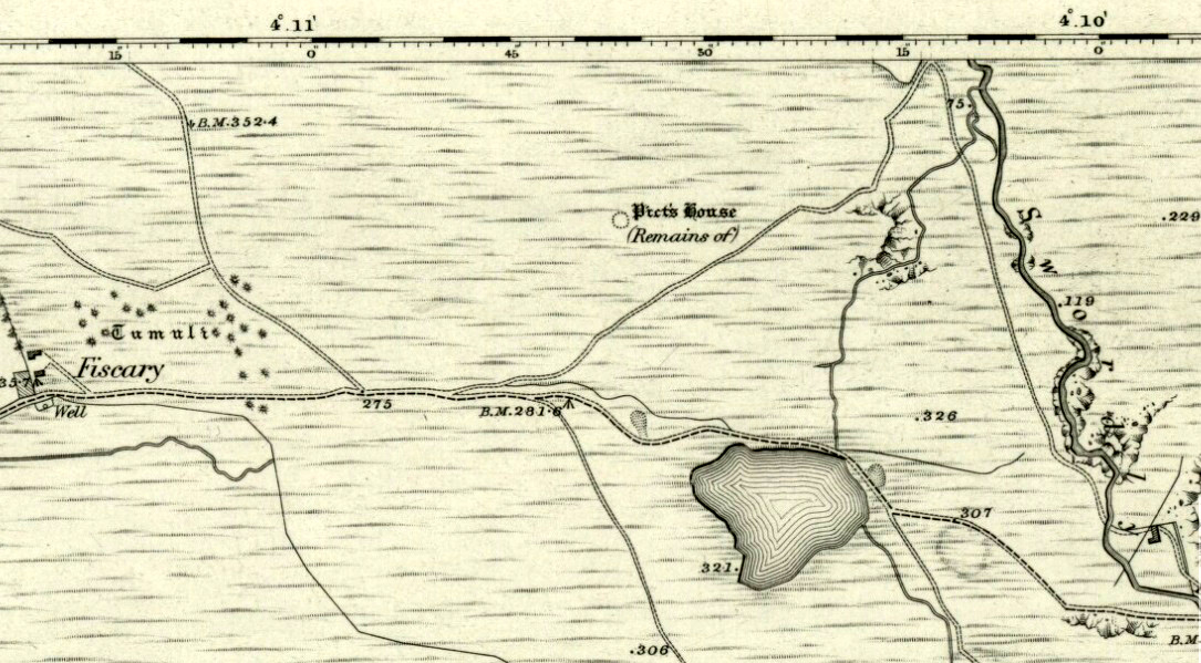
Included in Eamon Cody’s (2002) magnum opus, this site has long since gone. It was highlighted on the 1845-47 OS-map of the area and the only subsequent information about it was written in the 1903 Ordnance Survey Name Book, where it was described as a “supposed Giant’s Grave” that was marked by a large spread of boulders.
Perhaps the only thing we can ascertain here is from the name Giant’s Grave. Invariably, giants are part and parcel of creation myths in early traditional societies. Such giants, as well as being huge mythical creatures, can also be the progenitor of tribes and communities, i.e., the person who laid the initial foundation of where the tribe came to live, usually an early queen, king or shaman figure. So, in the case of this Giant’s Grave, it was likely to have been known as the burial place of such a figure: mythical in importance as well as size.
References:
Cody, Eamon, Survey of the Megalithic Tombs of Ireland: Volume VI – County Donegal, Duchas: Dublin 2002.
Chambered Cairn (destroyed): OS Grid Reference – C 003 396
Archaeology & History
In unpublished Notebooks written by one Thomas Fagan during the years 1845-48 (held by the National Archives in Dublin), he wrote how a local man had told him of the existence of “a supposed Druid’s Altar” in Claggan township, but its precise location has never subsequently been established. In Eamon Cody’s (2002) magnum opus he told what little we know about the place, saying,
“It stood on a slight rise adjoining Claggan Upper, the name assigned to a group of houses in the townland. It was reportedly encircled by “a wall or parapet” and consisted of several large upright stones2-4 feet high and arranged in two rows of few feet apart with a pillar at either end.”
The structure had been completely destroyed just a few years before Fagan’s visit to the place and no further information of it has yet been uncovered.
References:
Cody, Eamon, Survey of the Megalithic Tombs of Ireland: Volume VI – County Donegal, Duchas: Dublin 2002.
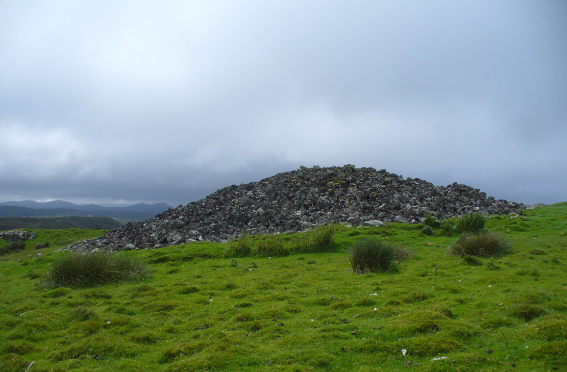
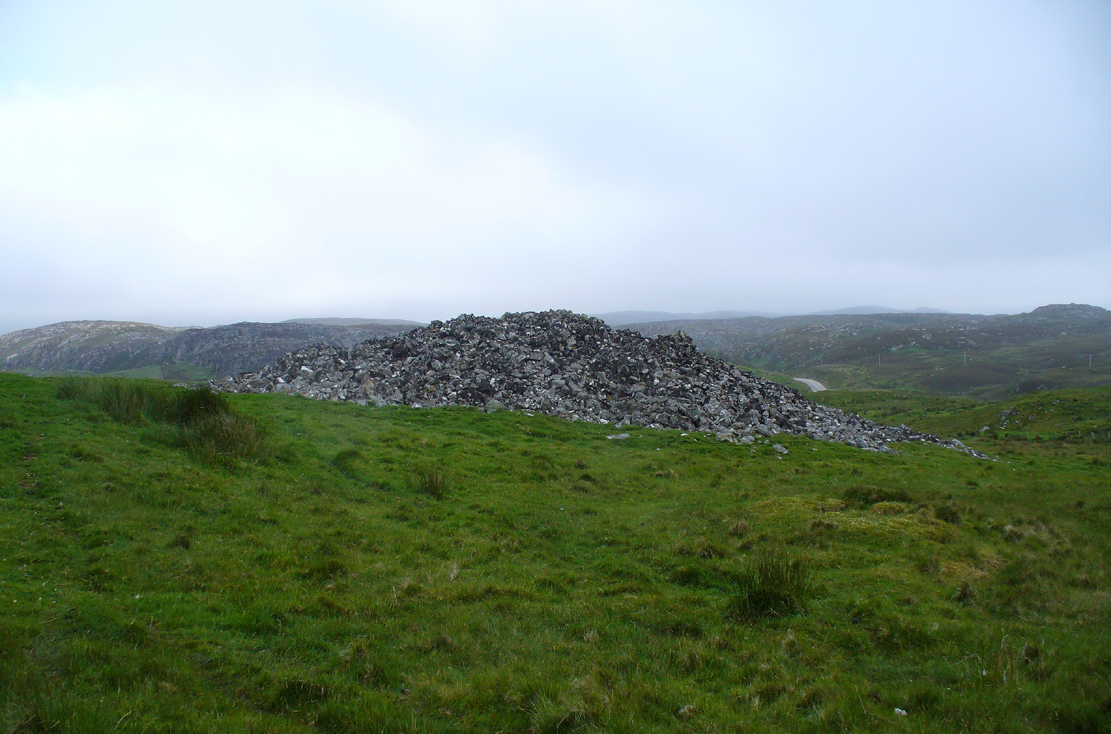
Along the A836 road from Bettyhill to Thurso, a mile east of the village keep your eyes peeled to your left (or to the right if you’re coming the other way!), looking north, and you’ll see some very large piles of stones a few hundred yards away. Go through the gate onto the rough grasslands and the first one you reach is the cairn in question. Y’ can’t miss it!
Archaeology & History
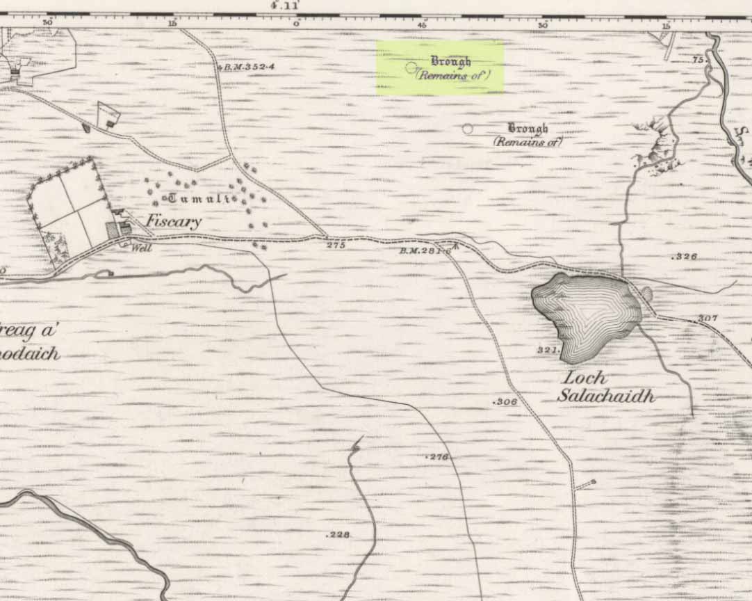
On 1878 OS-map as Picts House
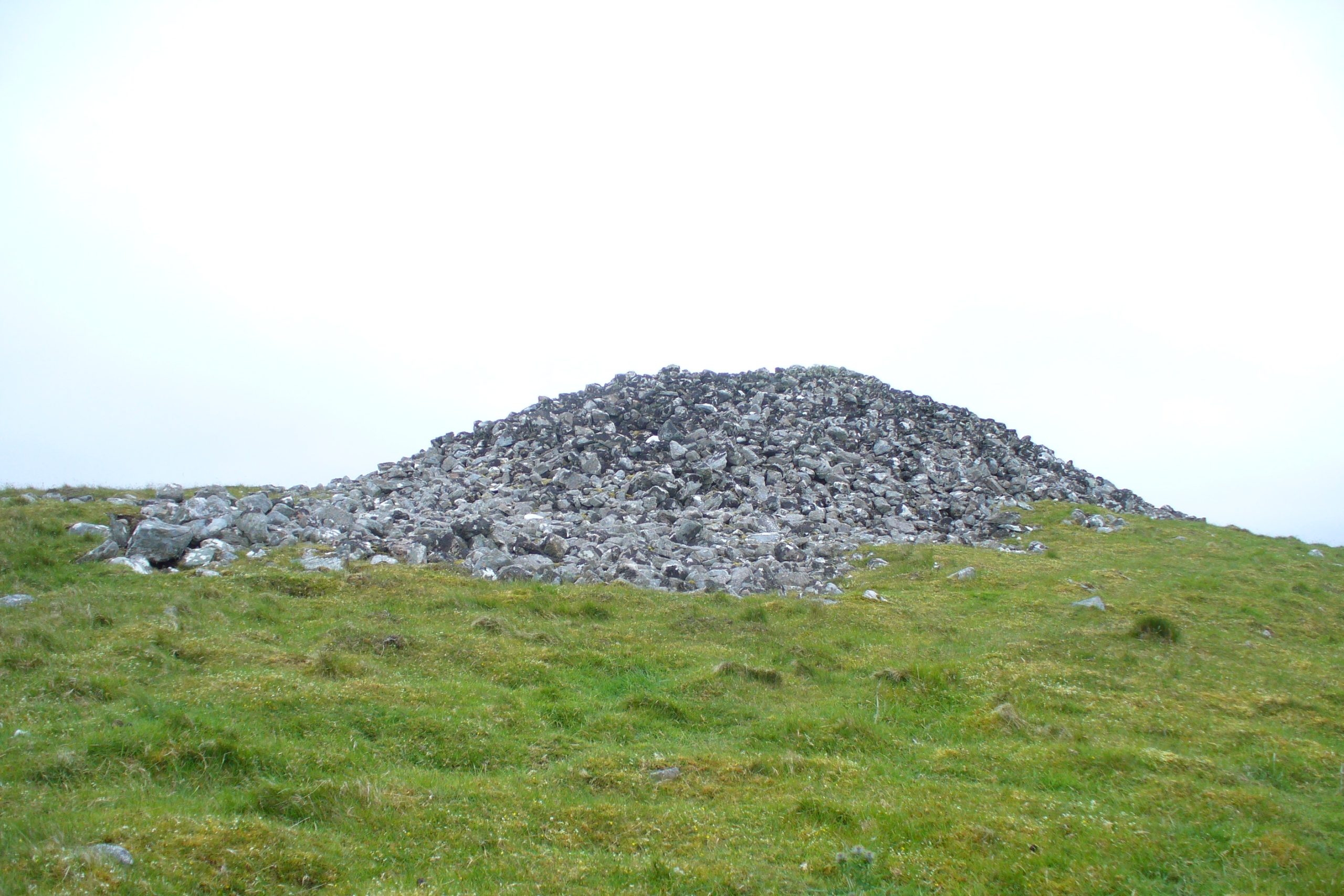
Close to the Fiscary 1 and Fiscary 2 tombs, this is the third and southernmost of the three giant cairns on this moorland hillside and is the second largest of the trio. Curiously it was the only one highlighted by the Ordnance Survey lads in their cartographic analysis here in 1873—they somehow missed the others—when they told it to be a ‘Pictish House’, or broch. A few years later when the Royal Commission (1911) fellas got their noses up here, they said that this,
“which is the most easterly, is circular in form, is about 68ft in diameter, and 15ft 6in to the apex, on which a small pile of stones has recently been erected. The cairn does not appear to have been excavated, but the stones in several places have been pulled out, probably in attempts to discover the chambers or in pursuit of rabbits.”
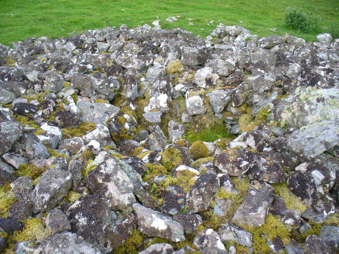
Looking into its centre
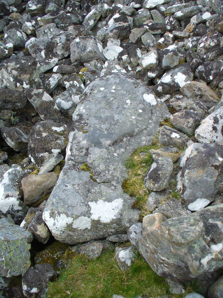
Long stone at southern edge
Considering the size of this giant cairn and its close association with is neighbours 150 yards northwest, I’m surprised at the lack of attention it’s been given. Within the collapse of stones on its southern-side we find an elongated stone which seems to have stood upright at some point in the past, either at the very edge of the cairn, or just inside it. It may even have been a covering stone to a collapsed entrance, but without an excavation we’re not gonna know for certain.
The fact that this cairn is on the slopes south of the crowning cairns of Fiscary 1 and Fiscary 2 implies that this was built some centuries later than them. Also notable here is that the view to the north is blocked and we are instead only looking across a panorama east, south and west.
Folklore
Looking across into the east
Local tradition told that this was a Pict’s house, or broch (it may well have been) and is shown as such on the first Ordnance Survey account of the region in 1878. Otta Swire (1963) told that this landscape was once peopled by giants who made the land and played a part in the creation of some of the giant tombs around here. One time local school-teacher at Bettyhill, Alan Temperley (1977) also told us how the fairy folk lived close to the giant tombs of Fiscary.
References:
Gourley, Robert, Sutherland: An Archaeological Guide, Birlinn: Edinburgh 1996.
Henshall, Audrey S., The Chambered Tombs of Scotland – volume 1, Edinburgh University Press 1963.
Henshall, Audrey S., “The Distant Past,” in The Sutherland Book (edited by Donald Omand), Northern Times: Golspie 1991.
Henshall, Audrey S., The Chambered Cairns of Sutherland, Edinburgh University Press 1995.
o’ Reilly, Kevin & Crockford, Ashley, What to See Around Bettyhill, privately printed 2009.
Royal Commission on Ancient & Historical Monuments, Scotland, Second report and inventory of monuments and constructions in the county of Sutherland. HMSO: Edinburgh 1911.
Sutherland, George, Folk-lore Gleanings and Character Sketches from the Far North, John o’ Groats Journal: Wick 1937.
Temperley, Alan, Tales of the North Coast, Research Publishing Company: London 1977.
Acknowledgments: HUGE thanks to Aisha Domleo and for getting me up here.
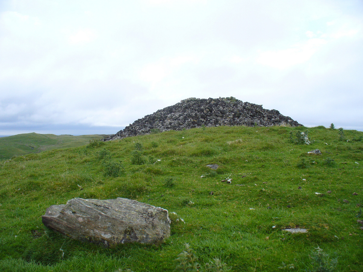
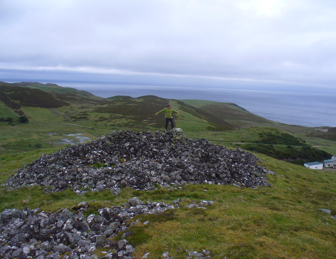
A mile east of Bettyhill along the A836 road, watch out for the large piles of rocks up on the hill on your left (north). Go through the gate, past the Fiscary 3 cairn and 150 yards northwest you’ll reach the crowning cairn on the hilltop itself – the Fiscary 2 cairn.
Archaeology & History
Fiscary 2 cairn, looking NW
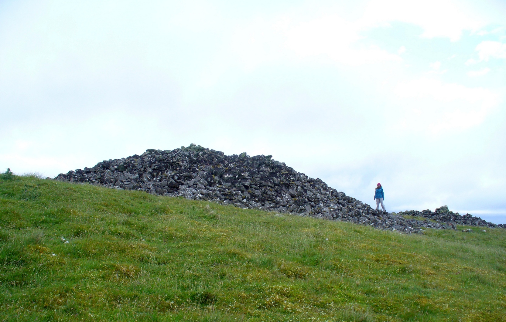
The second of the three giant chambered cairns on this moorland hillside is the largest (only just!) of them all. Positioned right on top of the small hill, this great mass of rocks stands out from the roadside a quarter-mile to the south quite blatantly, yet it somehow evaded the eyes of the early Ordnance Survey lads in their visit here in 1873 (though the nearby Fiscary 3 cairn was plotted). Odd…
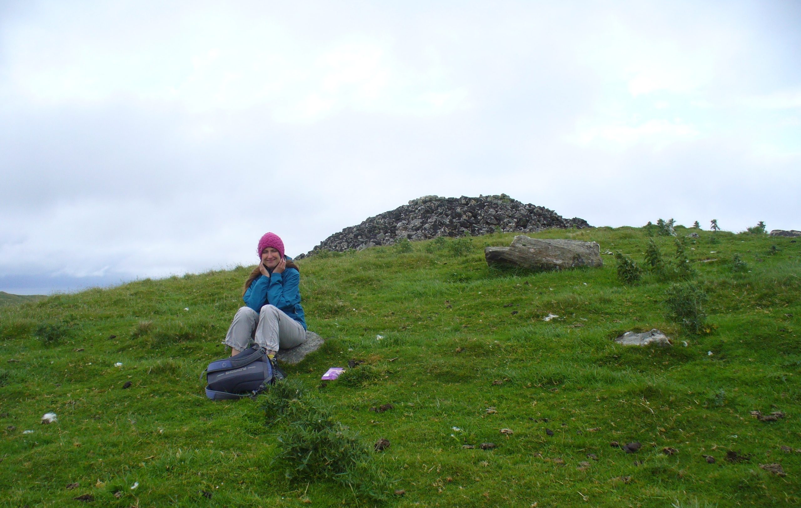
Aish by the side o’ the cairn
When I came here with Aisha and her clan a few weeks ago Nature was blasting us with full gales and so half her bunch returned after a short while, leaving us to get thrown about in the winds! Even just trying to stand upright on this and its associated tomb proved difficult. But despite this and the low grey clouds—typical of northern Scottish weather—it was obvious that the views from here would be superb, seeing far into the distance with a 360º view. I have little doubt that other important prehistoric sites would be speaking with this giant neolithic cairn, but there is nothing in the archaeology accounts to help us on such matters.
The giant tomb is almost linked to its companion—Fiscary 1—by a low scatter of rocks running between them, with only a yard or two separating their disturbed masses. Several archaeology students have posited that the two seemingly separate sites were, many thousands of years ago, perhaps one elongated chambered tomb, just like the ones found nearby at the Coille na borgie and Long Skelpick cairns; but it seems unlikely in this case…
Fiscary (2) on 1908 mapFiscary (2), looking SE
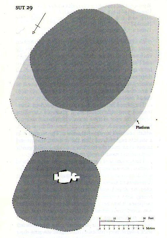
Although Adam Gunn (1893) mentioned the “four large cairns” at Fiscally (the fourth and smallest is 262 yards to the west), the first real description I can find of the place comes from an article by a local man called Cathel Kerr (1892) who told us it was “about 220 feet in circumference, and 15 or 16 in height”; but most of his article dealt with his excavation into the adjacent Fiscary 1 tomb, which he noticed was connected by a stone platform that ran between the two sites. This was the first mention of such a connecting platform—and a curious feature it is indeed. When the Royal Commission lads came here in May 1909 they also noted this connecting platform. They found that the cairn itself,
“does not appear to have been excavated. It is circular with a diameter of about 52ft and is some 10ft high to the top of the modern pile of stones on its apex. It presents a peculiar feature. At the north end is clearly visible a broad platform of stones extending to a distance of 25ft from the base of the cairn and, though largely overgrown with turf, traceable by the outline of stones almost entirely around it. This platform has been described as a neck connecting the two cairns (Fiscary 1 and 2, PB), but in reality it stops 7ft distant from the adjacent cairn.”
In strong gales at Fiscary 2Henshall’s plan of Fiscary 1 & 2
Indeed, this “platform” seems to have been either deliberately constructed with the hilltop cairn positioned on top of it, or has been set around the tomb. It’s difficult to say with any certainty without further excavation.
The great Audrey Henshall (1963; 1995) wrote extensively about this ancient monument in her works, finalizing her site entry in The Chambered Cairns of Sutherland (1995). After describing in some detail the obvious archaeological association this site has with Fiscary 1, she gave us a detailed description on this one and wrote:
“The larger south cairn (Fiscary 2, PB) is bare, steep-sided, and has been little disturbed. The diameters are between 19.5 to 21.5m, and the height is 5.5m measured from the NW. The edge is clear for about half of the circuit. The surrounding platform is quite low and is partly covered with peat and deep heather which in places obscure the edge. The platform varies in width from 4.8 to 7.3m. On the SE side the cairn edge is clear and there is no sign of the platform. It appears on the NE side where it is largely free of heather, and the cairn material merges into its stones. This part of the platform is edged by a rough kerb which fades away westwards into the spread of stones which links the two cairns. In the area between the cairns the stones are mainly covered by peat on which grow turf and heather. The spread of stones appears to be thin, but on the NW side of the cairn, where there is evidently a drop in ground level, breaks in the peat cover show that here the stone spread has considerable depth. Round the W side the platform is heather-covered, and along the SW part, where the hill drops away steeply, there is a rough kerb at a lower level than elsewhere, within which the surface of the platform rises to the base of the cairn. The S end of the platform, which here is bare stones, seems to turn sharply towards the S edge of the cairn, though the actual edge of the platform is indefinite.”
The likelihood is that this cairn is the oldest of the cluster of three found here, most likely constructed in the neolithic period. Its position in the landscape would indicate that the site would have been built to commemorate the spirit of a local tribal elder, a King or Queen. It’s a superb site and I’ll be visiting it again very soon indeed!
Folklore
Bouncy elven sprite flies by
The folklorist Otta Swire (1963) told that this region was once peopled by giants who created the landscape itself around here (a common attribute of giants the world over), and they also played a part in the creation of this and other giant tombs in the area. The one time local school-teacher at Bettyhill, Alan Temperley (1977), also told us that the fairy folk lived close to the giant tombs of Fiscary.
References:
Gourley, Robert, Sutherland: An Archaeological Guide, Birlinn: Edinburgh 1996.
Gunn, Adam & Mackay, John, Sutherland and the Reay Country, John Mackay: Glasgow 1893.
Henshall, Audrey S., The Chambered Tombs of Scotland – volume 1, Edinburgh University Press 1963.
Henshall, Audrey S., “The Distant Past,” in The Sutherland Book (edited by Donald Omand), Northern Times: Golspie 1991.
Henshall, Audrey S., The Chambered Cairns of Sutherland, Edinburgh University Press 1995.
o’ Reilly, Kevin & Crockford, Ashley, What to See Around Bettyhill, privately printed 2009.
Sutherland, George, Folk-lore Gleanings and Character Sketches from the Far North, John o’ Groats Journal: Wick 1937.
Temperley, Alan, Tales of the North Coast, Research Publishing Company: London 1977.
Acknowledgments: To the beautiful Aisha Domleo, for her images, bounce, spirit and madness – as well as getting me up to see this cluster of sites. And a Huge thanks for use of the Ordnance Survey map in this site profile, reproduced with the kind permission of theNational Library of Scotland.
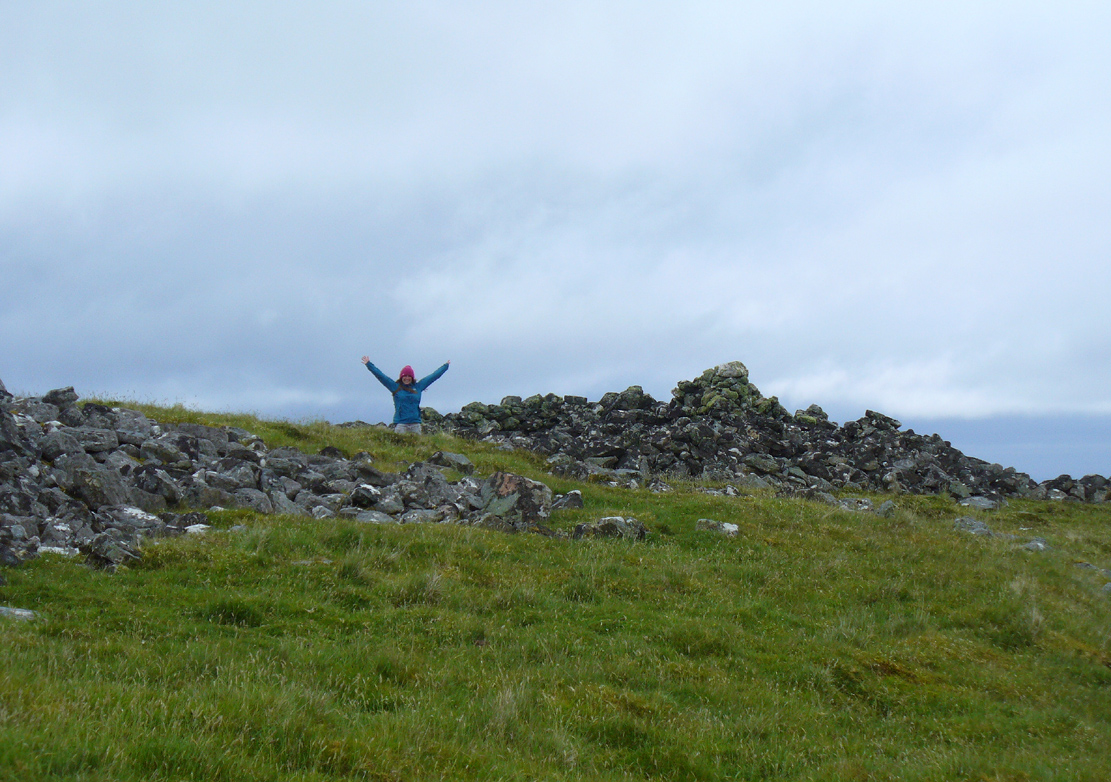
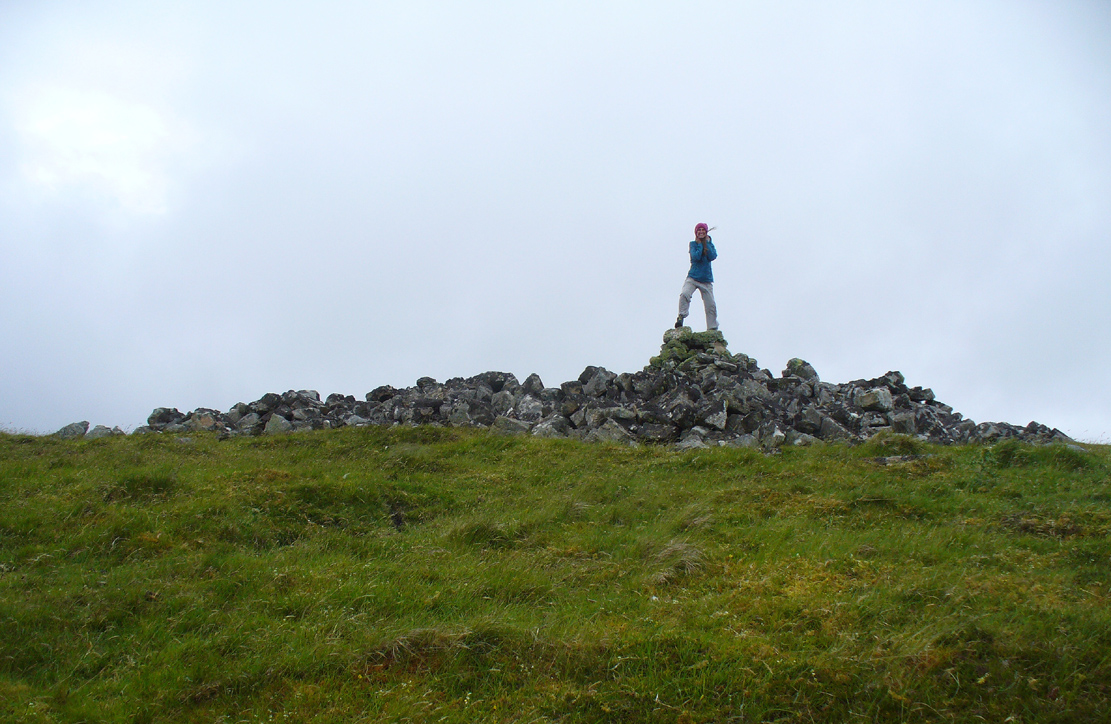
A mile east of Bettyhill on the A836 road, watch for the large piles of rocks up on the hill on your left (north). Go through the gate, past the Fiscary 3 cairn and 150 yards northwest you’ll reach the crowning cairn of Fiscary 2 on the hilltop itself. Fiscary 1 is just a few yards in front of you.
Archaeology & History
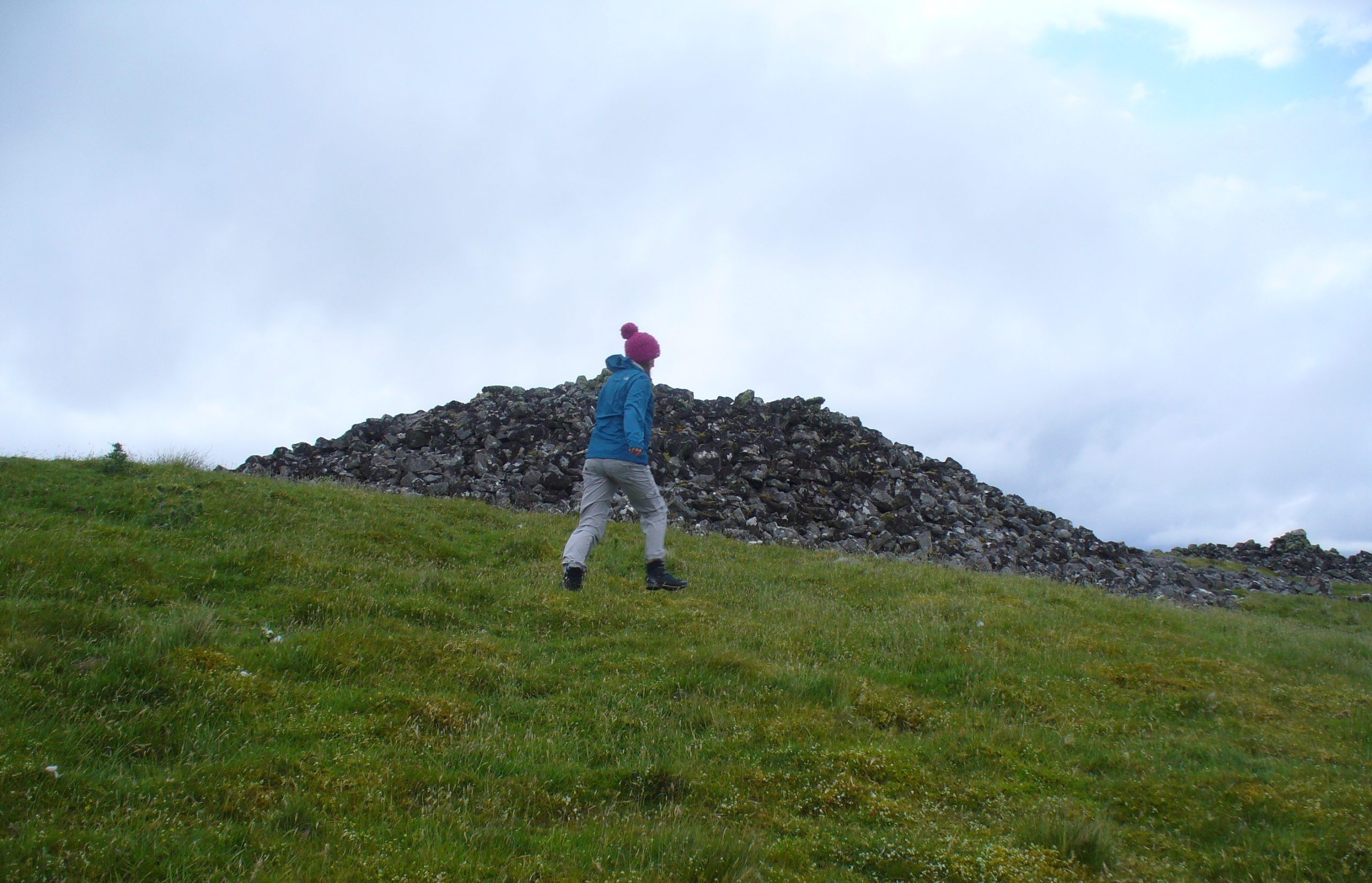
Although this is the smallest of the Fiscary cairns, it is the one that has had been investigated more than the others in this cluster—and you can tell as it’s been dug into. However, saying that, when Aisha and me were here a few weeks ago, the wind was blowing with such strength that we could give it little more than a cursory overview, as we were both getting blown about like a pair o’ puffters in the gale that was raging in from the sea! Twas quite overwhelming…
Fiscary 1 to the rear
One of the first things you notice is how this cairn is inextricably linked, both physically and otherwise, to its close partner on the hilltop only yards away: the Fiscary 2 cairn. Fiscary 2 reaches outwards towards where we now stand—slightly below the larger tomb immediately north (the airt of Death itself): almost as if an ancient Queen and Her King were resting still hand-in-hand in their respective burial sites.
Aisha on top!
…And although such romance may seem nothing more than that, recall that we are probably looking at two giant archaic monuments whose birth emerged in the neolithic: when time was measured by night, not day; when the Moon was Prima Mater’s aide and portender; and patriarchy had yet to be borne…. Giant hilltop cairns were the places of our ancient shaman-kings, queens and tribal elders, whose integral relationship with the cycles of the world to which we are (still) bound, were culturally very different in some fundamental ways, before rites of passage were disposed of…. But I’m moving away from the modern history of the Fiscary tomb…. Soz!
Around the time when some of the indigenous northerners up here were seeing the fading lights of their animistic cosmology disappear into the emergence of ‘history’, when the traditional tales were ebbing, Fiscary 1 was at least being written about—albeit in a detached way, as a museum piece, a piece of architecture. It’s the way things have become. The tomb was excavated by a local man called Cathel Kerr in the latter half of the 19th century, although he reported that it had already been dug into a few years earlier. Kerr told that some of the stones had been taken by an unnamed local for building purposes (not good!). “It had been opened from the top” he said—continuing:
“and there was abundant evidence around the cairn, that large slabs of stone had been removed from the interior. A little observation showed that there was the appearance of an internal chamber… The…cairn is about 150 feet in circumference and about 9 or 10 feet in height, and between it and (Fiscary 2) there is what seems to me to be a neck of stones joining the two cairns… Most of the neck joining the two cairns is covered over with turf, but a very slight observation reveals the fact that underneath it the mass of stones is continuous. The apparent depth of stones is from 3 to 4 feet. It is most unlikely that this neck could have been formed by stones falling from the top of the cairns.
“The chamber, when opened, proved to be tripartite. The entrance is from the west or northwest side, between two upright stones, with a large heavy slab thrown across them. The passage is only 3 or 4 feet long, and about 3 feet high, and nearly the same in width. This leads into a small chamber measuring about 6 feet by 3 feet. In front of it, on the north side, a large upright slab projects, and helps to form part of the end of the inner chamber and a division between the two on the south side. In all likelihood the stone corresponding to that one has been removed, so that there is nothing to mark the division between the chambers on that side. The larger chamber measures 6 feet 4 inches by 7 feet 9 inches. The sides are made up of large upright slabs and masonry, built up between the slabs. The corners are all rounded and there is the appearance of vaulting by the stones overlapping one another. The height of this chamber at present is about 5 feet. The end of the chamber is made up by two upright stones, with nearly 2 feet of an entrance between them, leading into the innermost chamber. This chamber is a very irregular oblong; indeed the ends are rounded. On an average it is 5 feet 9 inches long, by 33 inches wide, and 3 or 4 feet in height. It had the appearance of being covered over with slabs, some of which stood on edge inside; but of this I am not very sure, as the roofing of all the chambers has been interfered with.
“Inside there lay on the floor a large quantity of broken stones and black earth. Underneath there was what seemed a mixture of ashes and earth, with numerous pieces of charred wood, but no charred bones as far as I could see. Underneath that layer there was ordinary gravel. I found some fragments of bones on the innermost part, and some in the larger chamber. They do not appear to me to be of very great antiquity. A small vitrified mass was found on the floor.”
When the Royal Commission (1911) lads turned up to see the site in 1909 they reported—in a rather exaggerated manner—that the cairn “is now completely destroyed” and then in the next sentence said,
“The chamber is half filled-up with debris and only two or three large slabs remain, the others having disappeared. Its diameter has been about 46ft, and its height 4ft to 5ft.”
If the Royal Commission believe that’s an example of something being “completely destroyed”, they should turn their eyes and attention to sites like the Nixon’s Station cairn on top of Ilkley Moor which, when I was young, was larger than any of the Fiscary cairns; but somehow under the watchful eyes of the regional archaeologists in the 1980s and ’90s, was levelled to the ground – i.e., properly destroyed!
Audrey Henshall’s ground plan
In more recent years the cairn has received the honourable attention of the great Audrey Henshall (1963; 1995) who, in her updated site profile of Fiscary 1, told us not much more about the site than her predecessor Kerr. Contextualizing the place with its partner Fiscary 2 and the platform upon which it rests, she wrote:
“The paired cairns appear to be independent structures 8.5m apart, though a platform extending beyond the base of the south cairn, which has no internal features exposed, spreads to the base of the north cairn, which contains a ruined chamber… The north cairn is of bare angular stones with turf and heather only encroaching over the edges. Its limits are well-defined and give a roughly square plan with short diameters of 16.5m… Kerr exposed the roofless tripartite chamber, and most of the structure which he recorded was visible in 1955 (Henshall 1963). Less could be seen in 1992 as the chamber had been largely filled by loose stones…”
Much like the situation as it is today. More recently a small pile of stones has been added to the top of the cairn, from whence the view is excellent to the north, east and west. The larger Fiscary 2 cairn blocks the view directly south.
Folklore
Otta Swire (1963) not only told that this landscape was once peopled by giants who made the land and played a part in the creation of some of the giant tombs around here. The one time local school-teacher at Bettyhill, Alan Temperley (1977), also told us that the fairy folk lived close to the giant tombs of Fiscary.
References:
Eliade, Mircea, The Myth of the Eternal Return, RKP: London 1955.
Gourley, Robert, Sutherland: An Archaeological Guide, Birlinn: Edinburgh 1996.
Gunn, Adam & Mackay, John, Sutherland and the Reay Country, John Mackay: Glasgow 1893.
Henshall, Audrey S., The Chambered Tombs of Scotland – volume 1, Edinburgh University Press 1963.
Henshall, Audrey S., “The Distant Past,” in The Sutherland Book (edited by Donald Omand), Northern Times: Golspie 1991.
Henshall, Audrey S., The Chambered Cairns of Sutherland, Edinburgh University Press 1995.
o’ Reilly, Kevin & Crockford, Ashley, What to See Around Bettyhill, privately printed 2009.
Royal Commission on Ancient & Historical Monuments, Scotland, Second report and inventory of monuments and constructions in the county of Sutherland. HMSO: Edinburgh 1911.
Sutherland, George, Folk-lore Gleanings and Character Sketches from the Far North, John o’ Groats Journal: Wick 1937.
Temperley, Alan, Tales of the North Coast, Research Publishing Company: London 1977.
Acknowledgments: Huge thanks to beautiful Aisha Domleo again, for help with some of the photos – and adding your elegant spirit and energy to the place – as well as getting me up here in the first place!
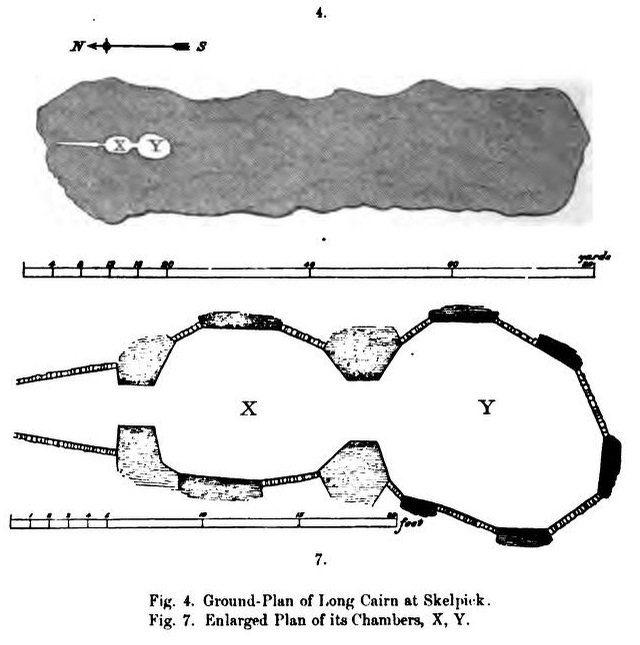
From the delightful village of Bettyhill, take the A836 road west. A mile out, just as the tiny road bridge crosses the sea-river, take the tiny road on your left. Go past the roadside lochan until you reach the first Skelpick house several miles down. Walk across the fields on your left (east) until you reach the wobbly wooden tidgy-widgy-bridgey that crosses the Skelpick Burn. Across on the other side – you can’t miss it!
Archaeology & History
The overgrown northern face
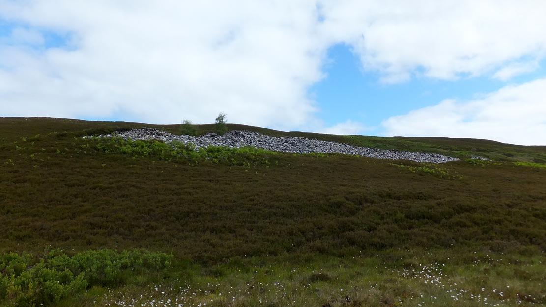
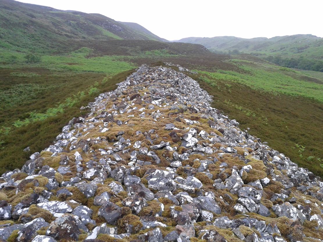
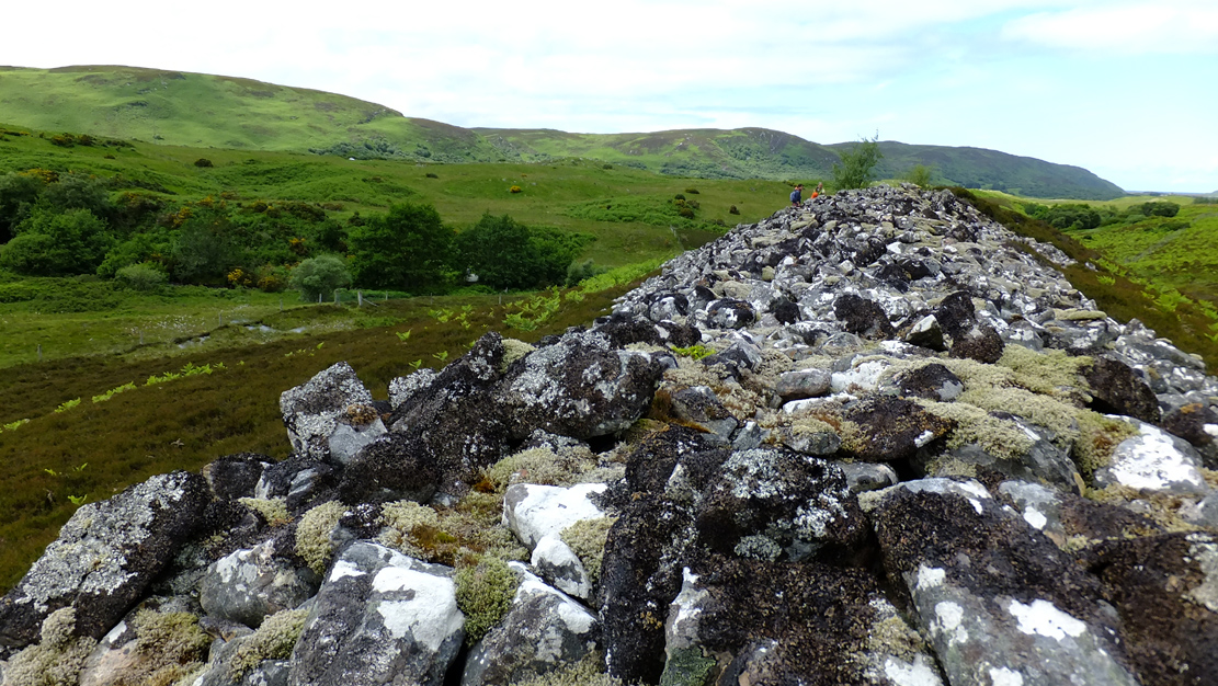
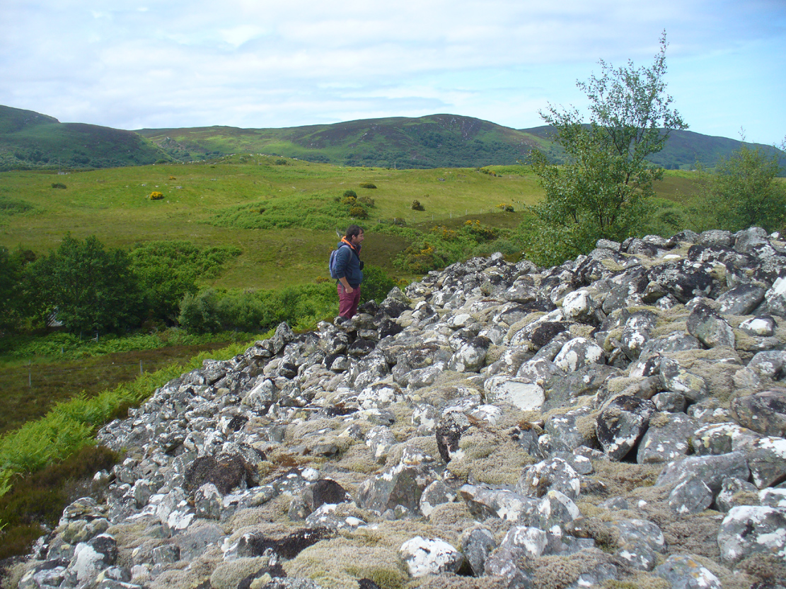
As you wander down the poetic geoscapes of Strathnaver, meandering back and forth along the tributaries and Her tiny primal forest remains, on the edges of Her marshes, rivulets and rocky moorlands, tomb after tomb raise themselves to the eyes and feet of the wanderer. They’re everywhere it seems! But this one, above all others, hits the eyesight with an unexpected magnitude. This is a giant–one helluva giant!–and typical of the structure and status of many of the immense prehistoric chambered tombs in this remote northern region of our entrancing heathen isles.
Rising out of the moorland heather to a height of sixteen feet in parts, tens of thousands of rocks make up this elongated artificial ridge, running like a spine NNW-SSE down the direction of the glen, pointing to the lowest dip in the distant southern horizon several miles away. And although overgrown when we visited the site, at each extremity the elongated cairn has curious stretches of stones projecting out of its sides, like a pair of horns at each end. Weird!
The long cairn, heading south
The giant cairn, heading north
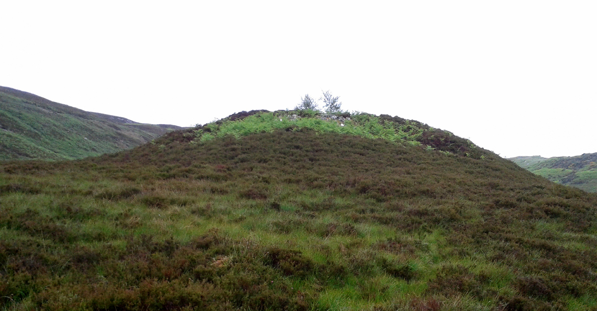
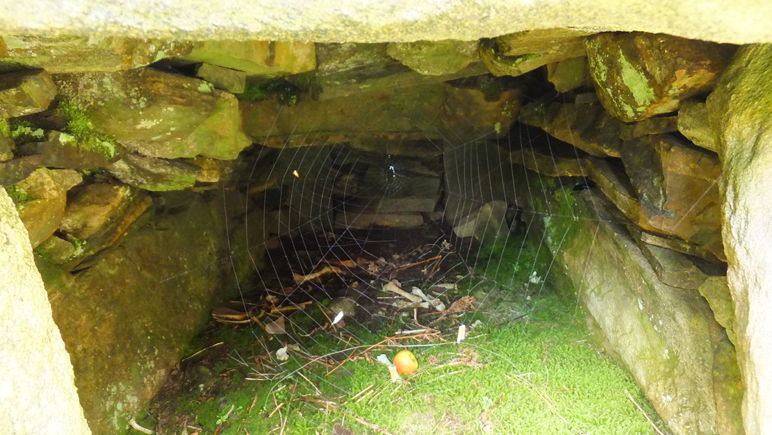
Once you get on top of the cairn, its northern end is the most impressive section. Wider than the rest of the monument, this is where, some ten feet below the top of the rock-pile, a large internal opening was covered over, hiding an impressive chamber (two birch trees mark the spot). This is in incredibly good condition when you remember that you are looking at something that was built in the neolithic period some 6000 years ago!
Spider guards chamber of bones
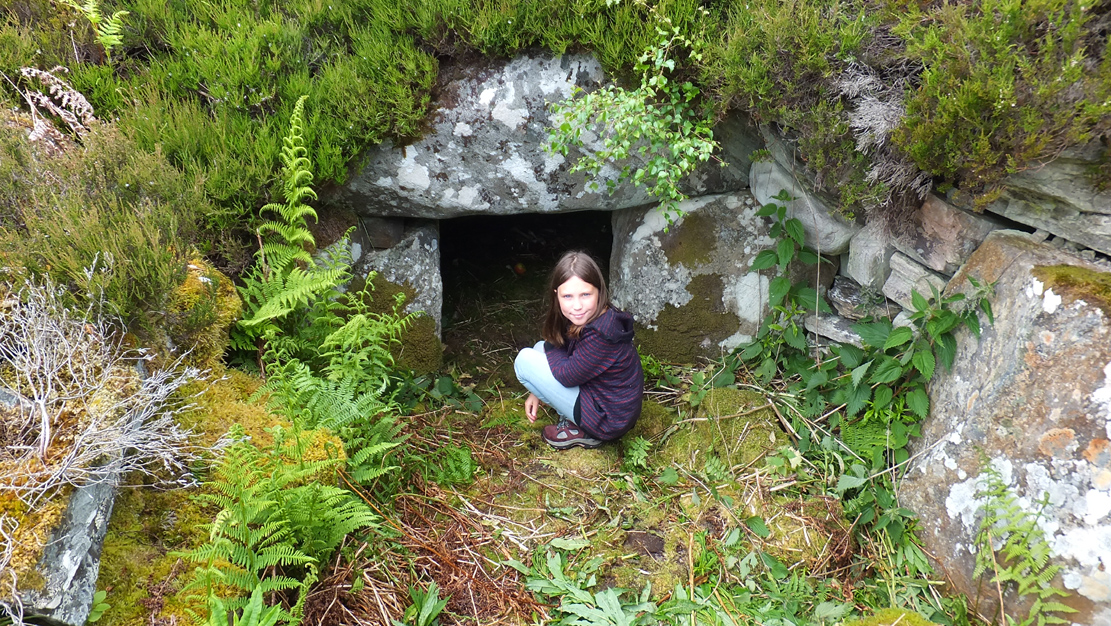
Little Lara at the entrance
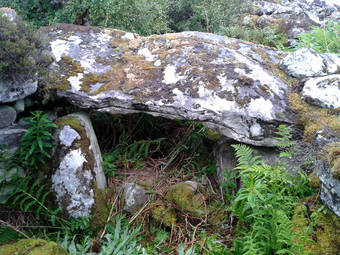
On my first visit, I sat inside the shelter of the chamber for around an hour, either inside the main ‘tomb’ section, or beneath a huge intact covering stone 12 feet outside the entrance (hiding from both rain and midges) that stretches from one side of the cairn to the other; noting, on its underside, two cup-marks: one is definitely crustacean in nature, whilst the other may be man-made (though we cannot discount it too having a crustacean origin). But we can safely say that this long stone was dragged some considerable distance from the coast to its present position and positioned into this giant cairn. This covering stone rests precariously on a collection of many small well-placed rocks, themselves held up on two rigid solid standing stones, deeply embedded god-knows-how-deep in the solid Earth. They stand about 3 feet high in their present position above the ground.
Central stone in chamber
Gordon gives idea of its size
The well-preserved ‘tomb’ section at the northern end of the cairn was opened sometime in the middle of the 19th century by James Horsburgh (1870)—although its description as a ‘tomb’ could be questionable here, as no funerary remains have ever been found inside it. Horsburgh described the site as a,
“long cairn, 80 or 90 yards in length, which I opened and came upon a polygonal-shaped chamber, 11 feet in diameter, the sides consisting of large stones 6 feet high, one of them 7 feet by 4 and 1½ feet thick, placed at a distance from each other of 3 or 4 feet, the intervals being built up with long square stones. The roof had been formed with very large flags overlaying each other. The chamber had been opened from the top and the whole inside was filled with stones and rubbish, so that I only cleared it out. Before I commenced operations, however, there was no appearance of it having been meddled with, and I dug it by chance where the cairn appeared to be highest. Nothing whatever was found in it.”
This lack of funerary remains may simply be due to the collapse of stones destroying any evidences at the time Horsburgh dug into the cairn—or it may have had other functions instead. Shortly after Horburgh’s analysis, John Stuart (1870) came to visit the site in his grand tour of the megaliths of the region, telling that,
“on the waterside is a long cairn with a chamber at its north end, of about 12 feet across, formed of six slabs, with the space between them carefully filled up with masonry. Some of the slabs are of great size. A passage leading to another chamber is blocked up. The walls of the chamber begin to converge at a height of 6 feet, and were probably covered by flags.”
Stuart’s 1874 ground plan
Long Skelpick on 1878 map
Highlighted on the first Ordnance Survey map in 1878, it was Mr Stuart (1874) who gave us our earliest ground-plan of Long Skelpick, as illustrated here. But since then the site has been described by a number of antiquarians and archaeologists. However, the most detailed account is given in the legendary Audrey Henshall’s (1995) updated site profile. I make no apologies for reproducing her lengthy account of this cairn almost in its entirety, as it is an astonishing megalithic monument. She wrote:
“…The cairn is 72m long overall, including the horns which define a forecourt at each end… The cairn is about 20m wide across the chamber, narrowing to 14m wide at a little south of centre, and expanding slightly to about 16m wide at the south end. At the north end the forecourt is difficult to define, though the ends of the horn are clear. Between them there is loose rubble which rises steeply to merge with the cairn material covering the passage, and which northwards merges into the downward slope of the ground. The passage entrance is hidden beneath this stony material; presumably there is deliberate blocking immediately in front of the entrance…but this has been covered by cairn material removed from the chamber area when it was investigated. The forecourt is about 13.5m wide by about 7m deep. The chamber is exposed in a deep hollow in the cairn, but south of it the cairn remains to a height of 3.4m (measured from the chamber floor), and from here to near the south end it continues as a ridge of bare irregular stones. Except for a few superficial hollows, it appears to be undisturbed, neither robbed nor substantially distorted, and it retains the steep pitch of its long sides. The cairn gradually diminishes in height southwards to about 2.8m high at about 12m north of the south forecourt. At this point there is a transverse hollow across the cairn 2.7m wide and about 0.7m deep, which may be an original feature (though in this area a relatively recent deep hollow has been made into the cairn from the east side reaching almost to the median line). The cairn has clearly been robbed from the south end to within 1.7m of the transverse hollow, presumably to build the square enclosure just to the south. The southeast horn is clear and the southwest horn can just be traced though it has probably been truncated. Between them, the edge of the forecourt is rather vague except for two laid slabs near the centre which appears to be part of an edging wall-face. The south forecourt has been about 10m wide and probably about 3.5m deep. The west edge of the cairn is clear though overgrown with heather, except for 20m at the north end where it is overlaid with bare stones evidently thrown down when the chamber was opened, and north of this the cairn merges into the natural slope. All along the east side the cairn merges with the slope of the ridge and has deep heather growing almost to the crest, so that the cairn edge is difficult to trace.
“The axis of the passage and chamber is nearly NNW to SSE, skew by about 13° by the axis of the cairn. The entrance can only be seen from the roofed passage. A pair of transverse stones set 0.56m apart forms the portal at the outer end of the passage. They are over 0.7m and 0.4m long, 0.25m and 0.18m thick, and 0.7m and 0.65m high. The original blocking, a neat stack of six horizontal slabs reaching to within 0.2m of the roof, is in place between them, with the south edges of the stones flush with the south faces of the portal stones. To the north of the slabs there can just be seen loose stones, smaller than those of the cairn material.
“The passage os 1.8m long and 1.15m wide at the outer end increasing to 1.3m wide at the inner end. A slab forms most of each wall. The slabs are 1.36m and 1.31m long by 0.5m and 0.45m high with two or three courses of walling above them, though this is displaced inwards and in a precarious state. Walling fills the short gaps at the ends of the stones, though missing from the NE corner. At the inner end of the passage a pair of portal stones forms the entry into the ante-chamber. They are 0.94m and 0.78m long by 0.26m and 0.44m thick, and 0.86m and 0.77m high, set 0.8m apart. At the outer end of the passage a lintel rests on the east portal stone and passes a little above the west portal stone, and the north edge of the lintel projects a little north of their outer faces. The lintel is 0.8m wide by 0.3m thick, 0.7m above the floor, tilted slightly down to the south. The next tow lintels rise in inverted steps, each overlapping the upper surface of that to the north with the third lintel 1m above floor level. The fourth lintel is missing and a gap of 0.5m is spanned by rubble; it is likely that a substantial stone at the top of each side wall is an end portion of this lintel, the centre part of which has broken away. The innermost lintel is lower, 0.86m above the floor, resting directly on the east portal stone and on a corbel stone over the shorter west portal stone at the chamber entrance. The lintel is over 2m long, 0.65m wide and 0.75m thick in the centre, and the face to the chamber is triangular.
“The chamber walls are constructed of spaced orthostats linked by panels of walling. All the orthostats are intact. The walling is of quite large quarried rectangular slabs, in general 0.07m to 0.02m thick, and where well-preserved can be seen to have been carefully built. At a height of about 0.7m the walling changes to courses of large corbel stones, often 0.23m to 0.4m thick, up to 0.9m wide, and 1m or so long. They are laid with their long axes running back into the cairn and their inner ends generally slightly oversailing; their appearance is rougher and heavier than the walling below. There is a considerable amount of displaced stone on the chamber floor, but all vertical measurements are taken from approximately floor level.
“The ante-chamber is about 2.5m long by 2.5m wide at the south end. The east wall consists of an orthostat 1.3m long by 0.36m thick, and 1.1m high, with a horizontal upper surface. The spaces between it and the outer and inner east portal stones of the chamber are filled with walling about 1.15m high, and above this and the orthostat are two courses of corbel stones giving a total height of 1.7m with a considerable overhang, at the southeast corner as much as 0.5m though possibly there has been some displacement. Only a short length at the south end of the west wall is visible. An orthostat set close to the west outer portal stone was visible in the 19th century…but this is hidden by rubble.
“The entrance between the ante-chamber and main chamber has been spacious, 1.06m wide and probably about 1.4m high. The portal stones are 0.85m and over 1.06m long, 0.42m and 0.25m to 0.4m wide, and 1.1m and 0.9m high, and their upper edges slope down into the cairn. The lintel above them is somewhat displaced with its wider face tilted down from south to north. Its east end rests on a corbel stone supported by displaced walling to the southeast of the portal stone, and its west end rests on displaced walling on the shoulder of the west portal stone and on the panel of walling to the southwest. The lintel is about 3m long by 1m wide and 0.35m thick.
“The main chamber is 3.5m long by about 3.25m wide. There are five orthostats in the wall. That on the axis has a horizontal upper surface and the others are rounded and rather irregular in shape. From the northeast, clockwise, they are 0.7m, 0.77m and 0.84m (at maximum 1.14m), over 1.3m and 0.86m long and, as far as can be seen, they vary from 0.1m to 0.4m thick. They are all of similar height, between 1 and 1.22m; the tallest is the northwest orthostat. Most of the linking walling remains. Between the east portal stone and the east orthostat only the upper courses are visible; between the east and southeast orthostats there are six neat courses of walling and above them three courses of corbel stones oversailing by 0.3m at a height of 1.7m (though the lowest courses of walling at the north end have been pulled away and the upper part of the wall is in danger of collapse). The walling between the southeast and the south orthostats has fallen away, but was intact in 1955… Between the south and southwest orthostats walling remains almost level with their tops and butts against the face of the latter, the south end of which is hidden. The last two panels of walling on the west side of the chamber survive to half the height of the adjacent orthostats.
“Part of the chamber was evidently visible in 1800 (Cardonnel …) and subsequently it must have been filled in. Horsburgh investigated the main chamber in 1866… His descriptions and measurements are fairly accurate except that he gave the height of the orthostats as 6ft and one as 7ft (1.8m and 2.1m); this seems to be an exaggeration as the present floor level, also extending down the passage, appears to be at approximately at the original level. He estimated that the roof height of the main chamber had been 10ft (3m)…
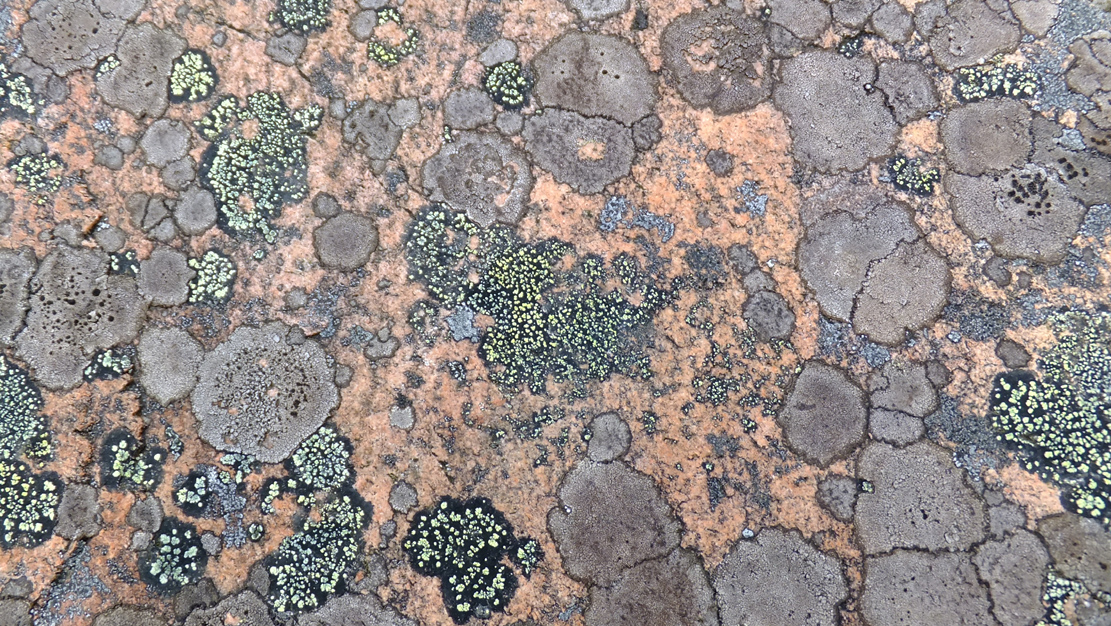
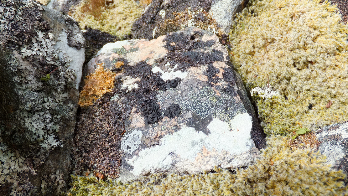
Old lichen upon the cairn-stones
Of mosses and lichens hereon…
Much of the length of the cairn is very overgrown in a living repertoire of medicinal mosses and lichens which, of themselves, are centuries old in places. Their profusion is a great indicator, not only of the cleanliness of the air betrayed in the cities of homo-profanus, but also a telling sign that visitors to this distant realm are few and far between. Tis a beautiful site in a spectacular ancient arena…
…to be continued…
Folklore
There is great superstition amongst some locals even today that this immense cairn should not be tampered with and it is said to be haunted.
References:
Gourley, Robert, Sutherland: An Archaeological Guide, Birlinn: Edinburgh 1996.
Henshall, Audrey S., The Chambered Tombs of Scotland – volume 1, Edinburgh University Press 1963.
Henshall, Audrey S., “The Distant Past,” in The Sutherland Book (edited by Donald Omand), Northern Times: Golspie 1991.
Henshall, Audrey S., The Chambered Cairns of Sutherland, Edinburgh University Press 1995.
Mackie, Euan W., Scotland: An Archaeological Guide, Faber: London 1975.
o’ Reilly, Kevin & Crockford, Ashley, What to See Around Bettyhill, privately printed 2009.
Royal Commission on Ancient & Historical Monuments, Scotland, Second report and inventory of monuments and constructions in the county of Sutherland. HMSO: Edinburgh 1911.
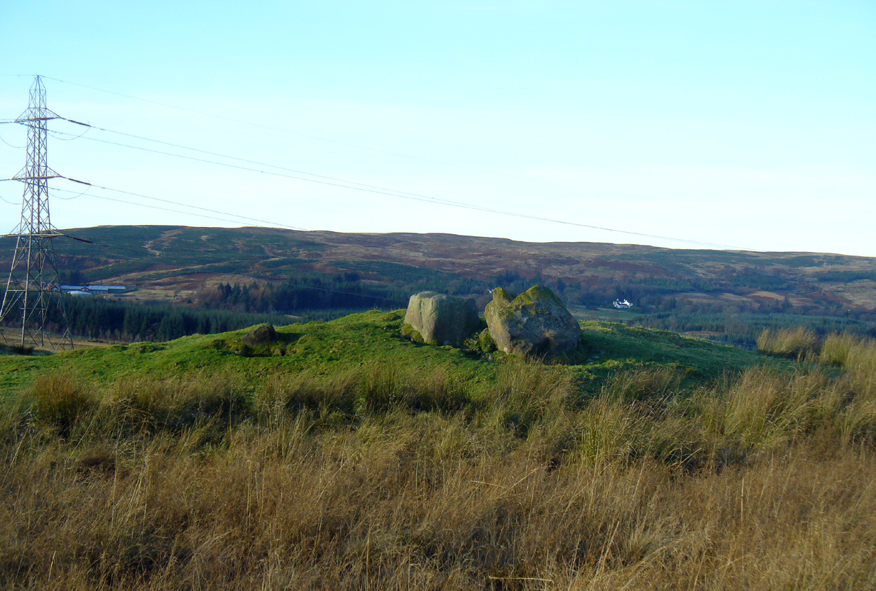
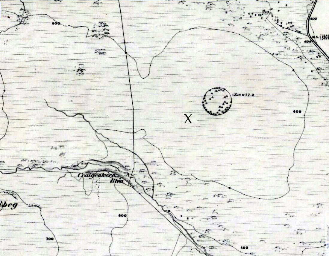
Take the A809 road several miles north out of Glasgow, between Bearsden and Drymen. Once out of the suburban sprawl, passing Milngavie, you’re heading to the famous Carbeth hutters. Before this, note the gold course on your right (east). Park here and cross the road where a gate and overgrown footpath takes you onto the grassy hills. Keep to the fence-side for about 700 yards until it veers downhill. Don’t walk downhill! Keep in the same direction into the short grasses and, veering gradually left, downhill for a couple hundred yards ahead and, across a small boggy area, you’ll note some large upright stones in front of a mound. That’s it!
Archaeology & History
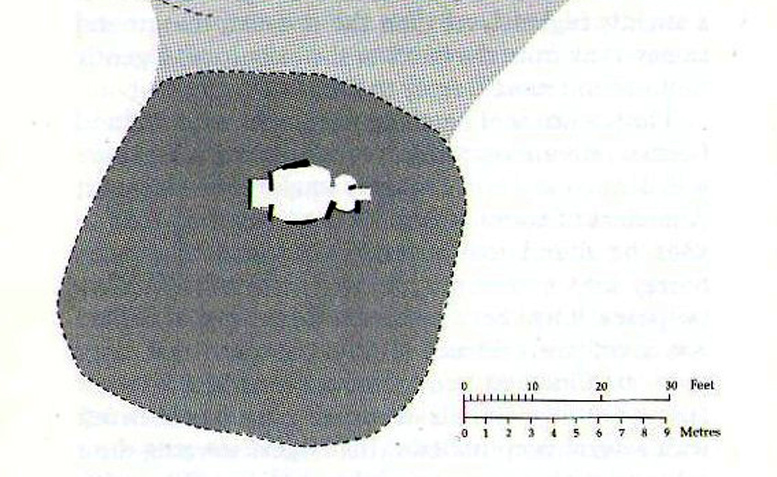
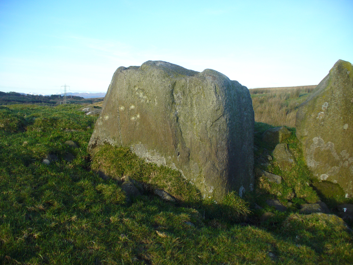
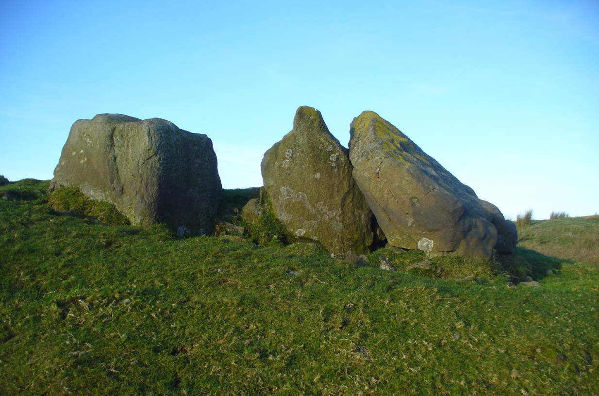
The SE stone ‘entrance’
There is no previous reference to this site which was found, quite fortuitously, by Nina Harris of Organic Scotland a few years ago. She visited the site a number of times, puzzling over the curious line of possible standing stones at the edge the grass-covered mound—wondering if it was anything at all. A few months ago she took us to see the place…
Modern gunshot cup-marks on entrance stone
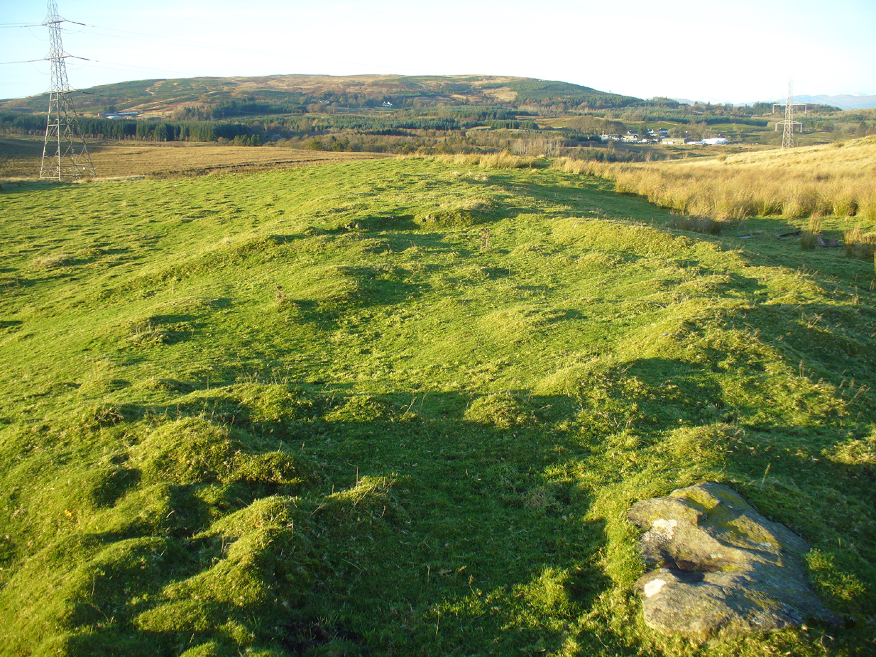
The site has been damaged and elements of it have been stripped for walling that are visible all around here. The cairn is more than 55 yards in length, running from its southeastern stone ‘entrance’ to the gradually diminishing northwestern edges. At its widest it is 14.6 yards (13.5m) across, near its southeastern end. The main three standing stones at its entrance are four-feet tall at the highest, with one of them leaning upon another; an adjacent fourth stone, smaller than the main three, is more embedded into the cairn mass a couple of yards away. Cup-marks on one of the three larger uprights here are recent gunshot marks; whilst the possible cup-marks on the largest upright are natural.
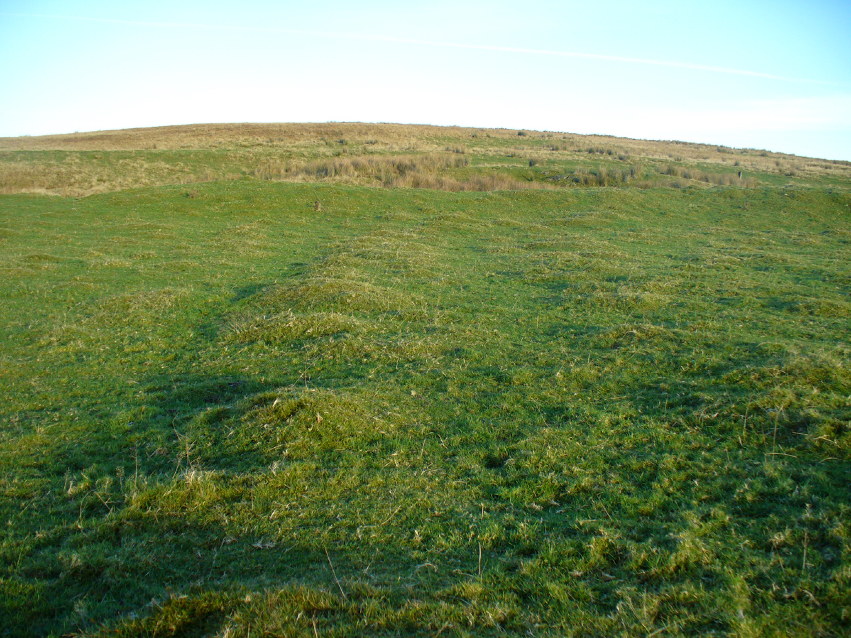
Line of ancient wall runs up and over the cairn
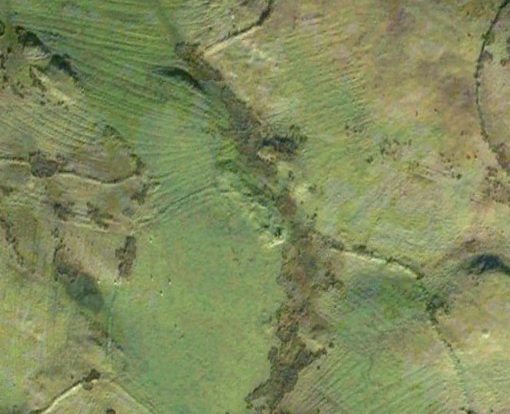
Looking NW along the cairn mass
In standing on top of the long cairn, just above the large stones, you can see how sections of it have been stripped away. Just beneath the surface is a line of internal walling, with what seems to be another one running parallel. These run for a few yards until we reach a large circular depression within the overall cairn mass, a yard deep and 6-7 yards across; on the northern edge of which we can clearly see a section of walling beneath the surface. When we look at the aerial view of this on Google Earth, we can clearly see how this walling actually begins way outside of the cairn mass itself, as a much denuded line of it (probably medieval in origin, though possibly Iron Age) curves across the grasslands from the west, crosses the long cairn and re-emerges on the other side of the adjacent boggy ground at its southeastern edges and continues on its way: indicating that the cairn mass beneath the wall is much older than the walls running across it.
“X” marks the spot!
The main three ‘entrance’ stones
Audrey Henshall (1972) described the existence of another prehistoric chambered tomb like this one at Cairnhowit 1.95 miles (3.14km) southwest, and we find the Stockie Muir long cairn 3.12 miles (5.02km) to the northwest, clearly showing that the incidence of this monument is not an isolated one. Others can be found not much further away. The existence of the raised geological plate known as Carneddans Wood just over a mile south may have once been home to another chambered cairn.
Please note that the grid reference for this site fixes on the southeastern section of the cairn, where the upright stones are.
References:
Henshall, Audrey S., The Chambered Tombs of Scotland – volume 2, Edinburgh University Press 1972.
Acknowledgements: First and foremost to Nina Harris, for unknowingly finding the place; also to Paul Hornby and Marion Woolley for visits to the site.
Long Barrow (destroyed): OS Grid Reference – TL 086 268
Archaeology & History
Aligned east-west, a large neolithic long barrow could once be seen to the west of Galley Hill, on where now we find a golf course. It was sadly destroyed sometime around 1900 AD and its demolition was witnessed by a Mr A. Cumberland of the Dartford Antiquarian Society, who reported there being no archaeological finds of note in the tomb. Curious…
Equally curious was the view of archaeologist James Dyer (1964) in his assessment of the site, who wrote how
“Air photographs suggest that the barrow was 300 ft long, but this is much larger than normal in the Chilterns, and 150 ft is more reasonable.”
The neolithic and Bronze Age burial specialist Paul Ashbee (1984) maintained the “300 feet” measurement.
Other tumuli can still be seen on the slopes either side of Galley Hill a few hundred yards to the east; and a henge monument has also be found in the area.
References:
Ashbee, Paul, The Earthen Long Barrow in Britain, Geo: Norwich 1984.
Dyer, J.F., “A Secondary Neolithic Camp at Waulud’s Bank, Leagrave,” in Bedfordshire Archaeological Journal 2, 1964.
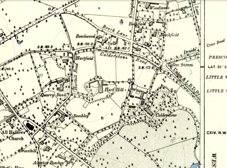
Access to these stones has, over recent years been pretty dreadful by all accounts. It’s easy enough to locate. Go into Calderstones Park and head for the large old vestibule or large greenhouse. If you’re fortunate enough to get one of the keepers, you may or may not get in. If anyone has clearer info on how to breach this situation and allow access as and when, please let us know.
Archaeology & History
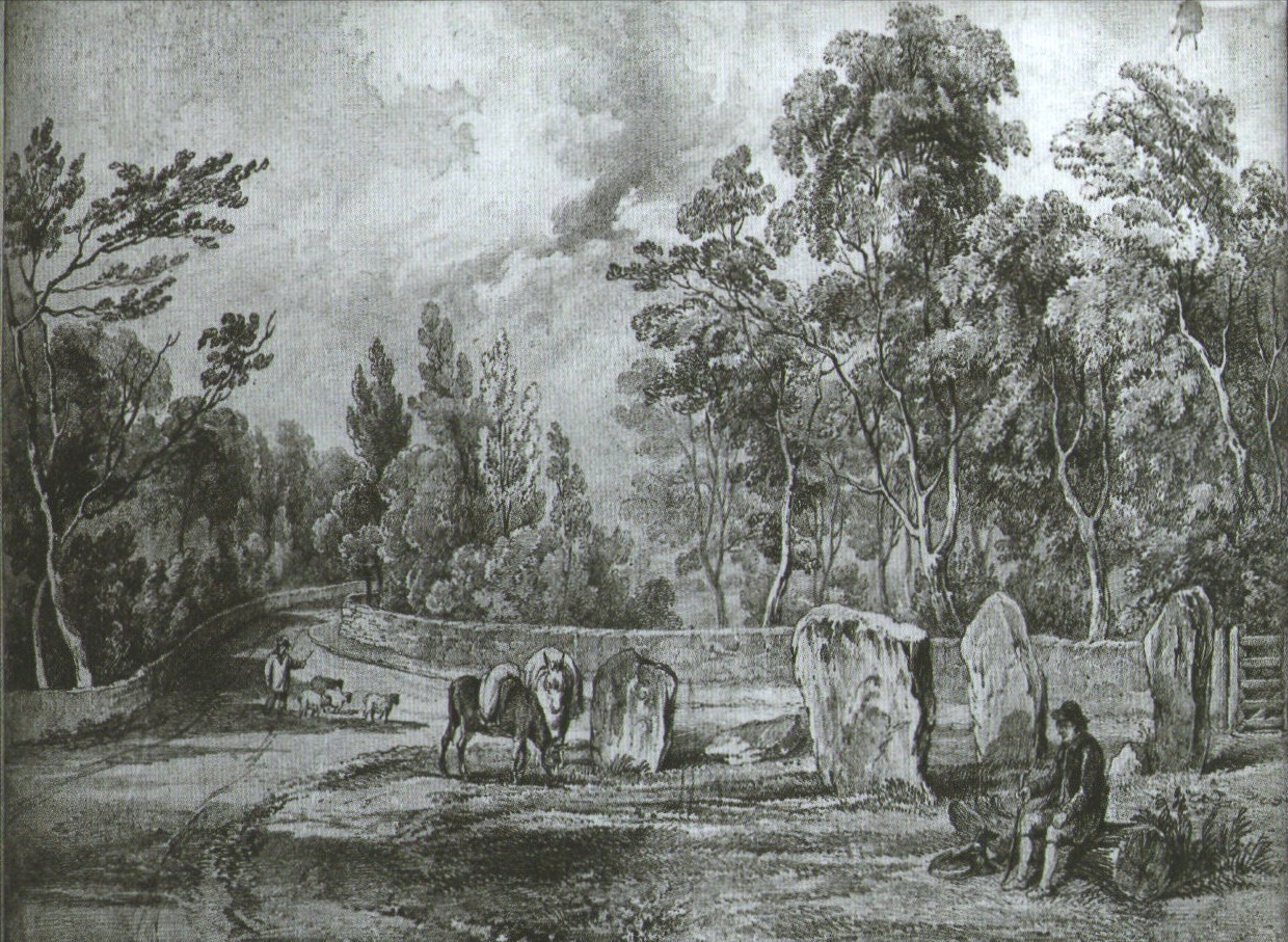
Earliest known drawing from 1825, showing the carvings
Marked on the 1846 Ordnance Survey map in a position by the road junctions at the meeting of township boundaries, where the aptly-named Calderstones Road and Druids Cross Road meet, several hundred yards north of its present site in Harthill Greenhouses in Calderstones Park, this is a completely fascinating site whose modern history is probably as much of a jigsaw puzzle as its previous 5000 years have been!
Thought to have originally have been a chambered tomb of some sort, akin to the usual fairy hill mound of earth, either surrounded by a ring of stones, or the stones were covered by earth. The earliest known literary reference to the Calderstones dates from 1568, where it is referenced in a boundary dispute, typical of the period when the land-grabbers were in full swing. The dispute was over a section of land between Allerton and Wavertree and in it the stones were called “the dojer, rojer or Caldwaye stones.” At that time it is known that the place was a roughly oval mound. But even then, we find that at least one of the stones had been taken away, in 1550.
Little was written about the place from then until the early 19th century, when descriptions and drawings began emerging. The earliest image was by one Captain William Latham in 1825. On this (top-right) we have the first hint of carvings on some of the stones, particularly the upright one to the right showing some of the known cup-markings that still survive. By the year 1833 however, the ‘mound’ that either surrounded or covered the stones was destroyed. Victorian & Paul Morgan (2004) told us,
“The destruction first began in the late 18th or early 19th century when the mound was largely removed to provide sand for making mortar for a Mr Bragg’s House on Woolton Road. It was at this time that a ‘fine sepulchral urn rudely ornamented outside’ was found inside.”
The Calderstones in 1840
The same authors narrated the account of the mound’s final destruction, as remembered by a local man called John Peers—a gardener to some dood called Edward Cox—who was there when it met its final demise. Mr Cox later wrote a letter explaining what his gardener had told him and sent it to The Daily Post in 1896, which lamented,
“When the stones were dug down to, they seemed rather tumbled about in the mound. They looked as if they had been a little hut or cellar. Below the stones was found a large quantity of burnt bones, white and in small pieces. He thought there must have been a cartload or two. He helped to wheel them out and spread them on the field. He saw no metal of any sort nor any flint implements, nor any pottery, either whole or broken; nor did he hear of any. He was quite sure the bones were in large quantity, but he saw no urn with them. Possibly the quantity was enhanced by mixture with the soil. No one made such of old things of that sort in his time, nor cared to keep them up…”
But thankfully the upright stones remained—and on them were found a most curious plethora of neolithic carvings. After the covering cairn had been moved, the six remaining stones were set into a ring and, thankfully, looked after. These stones were later removed from their original spot and, after a bit of messing about, came to reside eventually in the curious greenhouse in Calderstones Park.
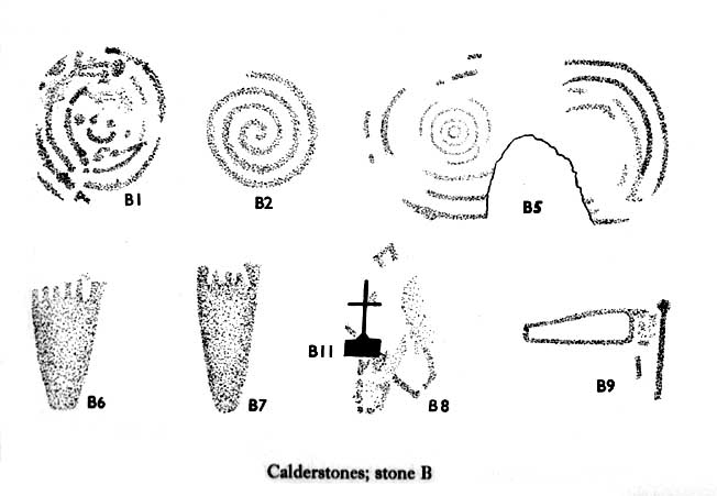
Simpson’s “Stone 1” outer faceSimpson’s “Stone 1” inner face
The carvings on the stones were first described in detail by the pioneering James Simpson. (1865) I hope you’ll forgive me citing his full description of them—on one of which he could find no carvings at the time, but he did state that his assessment may be incomplete as the light conditions weren’t too good. Some things never change! Sir James wrote:
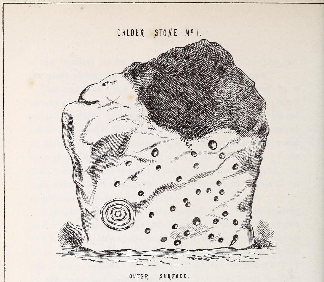
“The Calder circle is about six yards in diameter. It consists of five stones which are still upright, and one that is fallen. The stones consist of slabs and blocks of red sandstone, all different in size and shape.
“The fallen stone is small, and shews nothing on its exposed side; but possibly, if turned over, some markings might be discovered on its other surface.
“Of the five standing stones, the largest of the set (No. I) is a sandstone slab, between five and six feet in height and in breadth. On its outer surface—or the surface turned to the exterior of the circle— there is a flaw above from disintegration and splintering of the stone; but the remaining portion of the surface presents between thirty and forty cup depressions, varying from two to three and a half inches in diameter; and at its lowest and left-hand corner is a concentric circle about a foot in diameter, consisting of four enlarging rings, but apparently without any central depression.
“The opposite surface of this stone, No. 1, or that directed to the interior of the circle, has near its centre a cup cut upon it, with the remains of one surrounding ring. On the right side of this single-ringed cup are the faded remains of a concentric circle of three rings. To the left of it there is another three-ringed circle, with a central depression, but the upper portions of the rings are broken off. Above it is a double-ringed cup, with this peculiarity, that the external ring is a volute leading from the central cup, and between the outer and inner ring is a fragmentary line of apparently another volute, making a double-ringed spiral which is common on some Irish stones, as on those of the great archaic mausoleum at New Grange, but extremely rare in Great Britain. At the very base of this stone, and towards the left, are two small volutes, one with a central depression or cup, the other seemingly without it. One of these small volutes consists of three turns, the other of two.
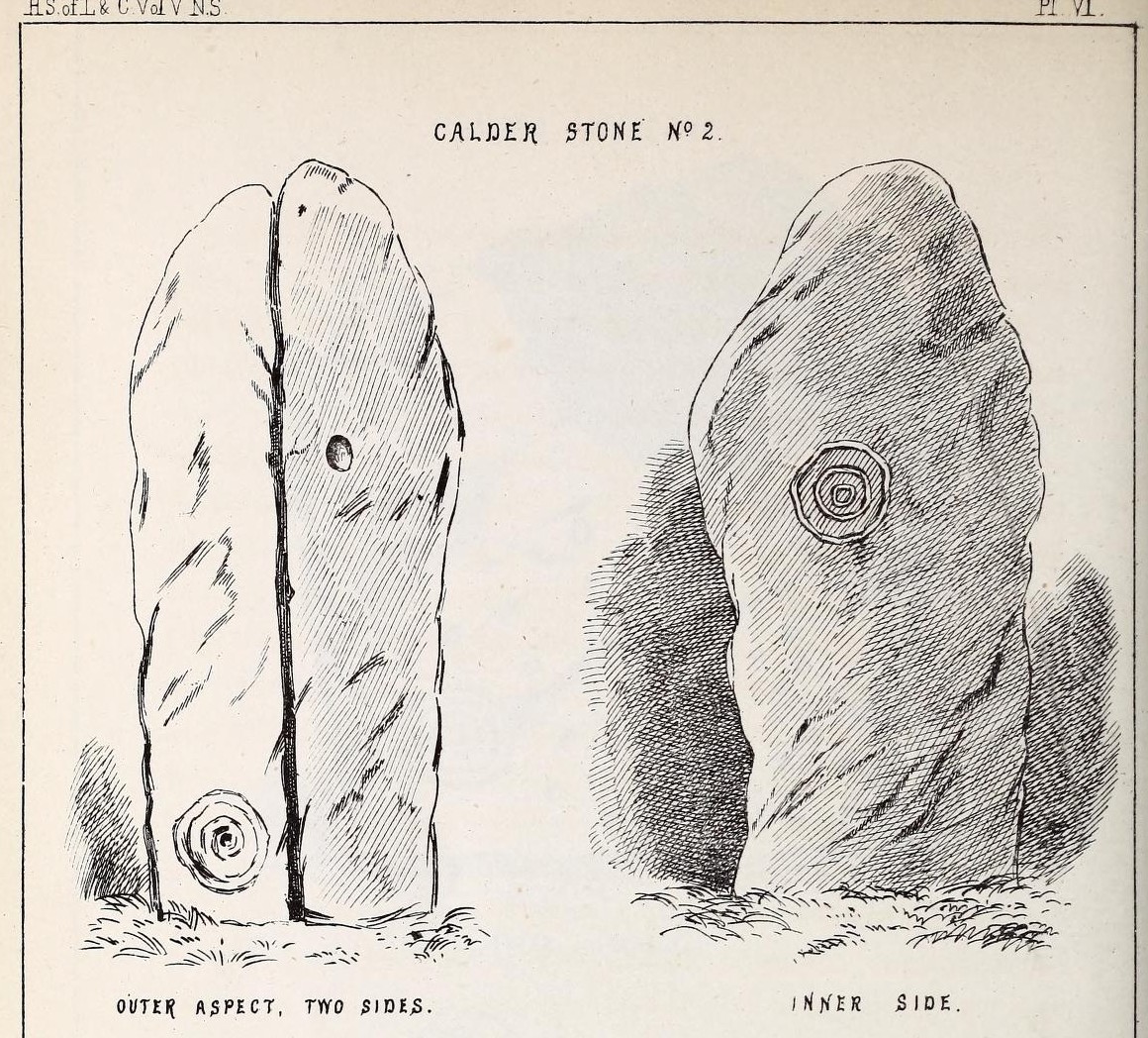
“The next stone, No. 2 in the series, is about six feet high and somewhat quadrangular. On one of its sides, half-way up, is a single cup cutting; on a second side, and near its base, a volute consisting of five rings or turns, and seven inches and a half in breadth ; and on a third side (that pointing to the interior of the circle), a concentric circle of three rings placed half-way or more up the stone.
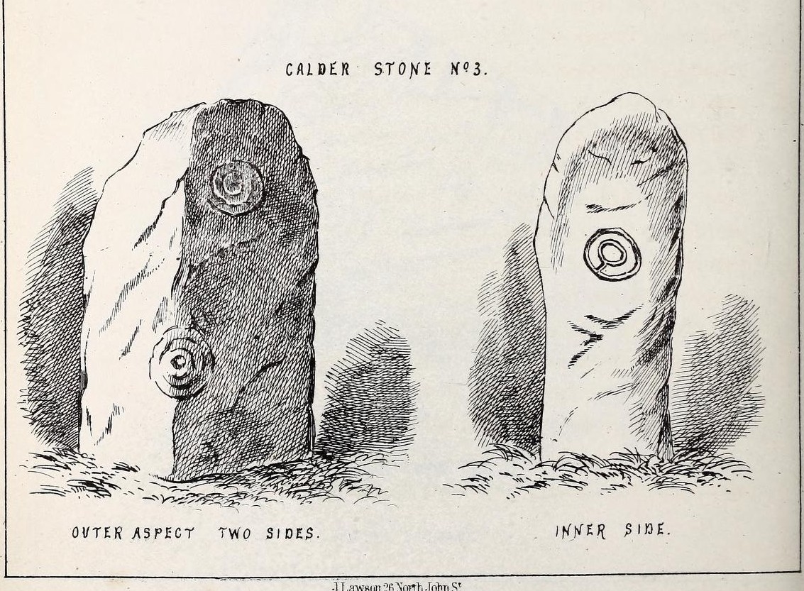
“The stone No. 3, placed next to it in the circle, is between three and four feet in height; thick and somewhat quadrangular, but with the angles much rounded off. On its outermost side is apparently a triple circle cut around a central cup; but more minute examination and fingering of the lines shews that this figure is produced by a spiral line or volute starting from the central cup, and does not consist of separate rings. The diameter of the outermost circle of the volute is nearly ten inches. Below this figure, and on the rounded edge between it and the next surface of the stone to the left, are the imperfect and faded remains of a larger quadruple circle. On one of the two remaining sides of this stone is a double concentric circle with a radial groove or gutter uniting them. This is the only instance of the radial groove which I observed on the Calder Stones, though such radial direct lines or ducts are extremely common elsewhere in the lapidary concentric circles.
“The stone No. 4 is too much weathered and disintegrated on the sides to present any distinct sculpturings. On its flat top are nine or ten cups ; one large and deep (being nearly five inches in diameter). Seven or eight of these cups are irregularly tied or connected together by linear channels or cuttings…
“The fifth stone is too much disfigured by modern apocryphal cuttings and chisellings to deserve archaeological notice.
“The day on which I visited these stones was dark and wet. On a brighter and more favourable occasion perhaps some additional markings may be discovered.”
It wasn’t long, of course, before J. Romilly Allen (1888) visited the Calderstones and examined the carvings; but unusually he gave them only scant attention and added little new information. Apart from reporting that another of the monoliths had carvings on it, amidst a seven-page article the only real thing of relevance was that,
“Five of the Calderstones show traces, more or less distinct, of this kind of carving, the outer surface of the largest stone having about thirty-six cups upon it, and a set of four concentric rings near the bottom at one corner. One of the stones has several cups and grooves on its upper surface.”
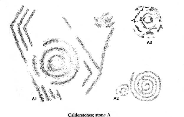
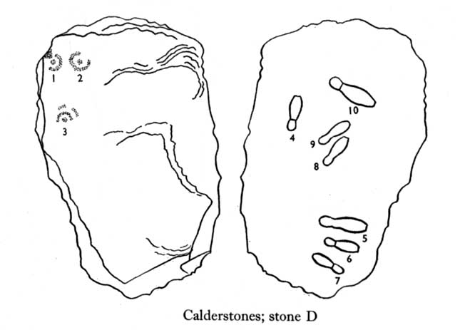
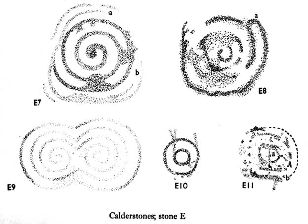
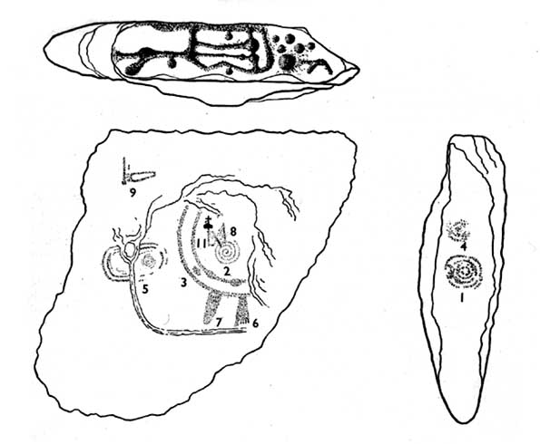
Carvings on Stone A (after Forde-Johnson)Carvings on Stone B (after Forde-Johnson)
Unusual for him! The major survey of the Calderstone carvings took place in the 1950s when J.L. Forde-Johnson (1956; 1957) examined them in great detail. His findings were little short of incredible and, it has to be said, way ahead of his time (most archaeo’s of his period were simply lazy when it came to researching British petroglyphs). Not only were the early findings of Sir James Simpson confirmed, but some fascinating rare mythic symbols were uncovered that had only previously been located at Dunadd in Argyll, Cochno near Glasgow, and Priddy in Somerset: human feet – some with additional toes! Images of feet were found to be carved on Stones A, B and E. A carved element on Stone C may even represent a human figurine—rare things indeed in the British Isles!
Carvings on Stone DCarvings on Stone E
The detailed sketches here are all from Forde-Johnson’s 1957 article, where five of the six stones were found to bear petroglyphs (the sixth stone has, more recently, also been found to also possess faint carvings of a simple cup-mark and five radiating lines).
Elements on Stone C (after Forde-Johnson)More elements on Stone C (after Forde-Johnson)
The date of the site is obviously difficult to assess with accuracy; but I think it is safe to say that the earlier archaeological assumptions of the Calderstones being Bronze Age are probably wrong, and the site is more likely to have been constructed in the neolithic period. It’s similarity in structure and form to other chambered tombs—mentioned by a number of established students from Glyn Daniel (1950) to Frances Lynch—would indicate an earlier period. The fact that no metals of any form have ever been recovered or reported in any of the early accounts add to this neolithic origin probability.
There is still a lot more to be said about this place, but time and sleep are catching me at the mo, so pray forgive my brevity on this profile, until a later date…
Folklore
Curiously, for such an impressive site with a considerable corpus of literary references behind it, folklore accounts are scant. The best that Leslie Grinsell (1976) could find in his survey was from the earlier student C.R. Hand (1912), who simply said that,
“They were looked upon with awe by the people about as having some religious significance quite beyond their comprehension.”
There is however, additional Fortean lore that has been written about these stones and its locale by John Reppion (2011).
Ashbee, Paul, The Bronze Age Round Barrow in Britain, Phoenix House: London 1960.
Baines, Thomas, Lancashire and Cheshire, Past and Present – volume 2, William MacKenzie: London 1870.
Beckensall, Stan, British Prehistoric Rock Art, Tempus: Stroud 1999.
Beckensall, Stan, Circles in Stone: A British Prehistoric Mystery, Tempus: Stroud 2006.
Cowell, Ron, The Calderstones – A Prehistoric Tomb in Liverpool, Merseyside Archaeological Trust 1984.
Crawford, O.G.S., The Eye Goddess, Phoenix House: London 1957.
Daniel, Glyn E., The Prehistoric Chamber Tombs of England and Wales, Cambridge University Press 1950.
Faulkner, B.M., “An Analysis of Three 19th-century Pictures of the Calderstones,” in Merseyside Archaeological Journal, volume 13, 2010.
Forde-Johnson, J.L., “The Calderstones, Liverpool,” in Powell & Daniel, Barclodiad y Gawres: The excavation of a Megalithic Chambered Tomb in Anglesey, Liverpool University Press 1956.
Forde-Johnson, J.L., “Megalithic Art in the North West of Britain: The Calderstones, Liverpool,” in Proceedings of the Prehistoric Society, volume 23, 1957.
Grinsell, Leslie, Folklore of Prehistoric Sites in Britain, David & Charles: Newton Abbot 1976.
Hand, Charles R., The Story of the Calderstones, Hand & Co.: Liverpool 1912.
Herdman, W.A., “A Contribution to the History of the Calderstones, near Liverpool,” in Proceedings & Transactions of the Liverpool Biological Society, volume 11, 1896.
Morgan, Victoria & Paul, Prehistoric Cheshire, Landmark: Ashbourne 2004.
Nash, George & Stanford, Adam, “Recording Images Old and New on the Calderstones in Liverpool,” in Merseyside Archaeological Journal, volume 13, 2010.
Picton, James A., Memorials of Liverpool – 2 volumes, Longmans Gree: London 1875.
Simpson, James, Archaic Sculpturings of Cups, Circles, etc., Upon Stones and Rocks in Scotland, England and other Countries, Edmonston & Douglas: Edinburgh 1867.
Taylor, Isaac, Words and Places, MacMillam: London 1885.
Stewart-Brown, Ronald, A History of the Manor and Township of Allerton, Liverpool 1911.
Acknowledgements: With huge thanks to the staff at Calderstones Park; thanks also to the very helpful staff at Liverpool Central Library.
From Tregele village, take the minor southeast road towards Llanfechell, until you pass the second dirt-track on your right (both tracks take you to a local farm). The second track takes you to the aptly-named farmhouse of ‘Cromlech’ – which is where you need to ask the farmer (a friendly chap) if you can have a gander at his rocks! To which he should say, “Aye…it’s over there in the field.” You can’t really miss ’em!
Archaeology & History
This was once an impressive prehistoric tomb by the size of things, but has been knocked about a bit over the centuries. Even when Glyn Daniel (1950) described it, he said that “at present this site consists of nothing more than a number of large stones lying in a field — some flat and others slightly tilted.” And it hasn’t changed much since then! One of the earliest descriptions of Foel Fawr was by John Skinner (1908) in his fine tour around Anglesey in the early 19th century, where he told:
Skinner’s 1804 drawingFoel Fawr tomb
“From hence passing by an old mansion named Cromlech now tenanted by a farmer we came to the spot where many large stones were lying scattered promiscuously on the ground and one nearly square measuring nine feet across leaning against some uprights about six feet high. From the appearance of this place I should rather imagine that it had been the interior or cistfaen of a carnedd and this opinion seems somewhat confirmed by the accounts of the common people who remember great quantities of stone having been removed to form a wall.”
References:
Daniel, Glyn E., The Prehistoric Chamber Tombs of England and Wales, Cambridge University Press 1950.
Skinner, John, Ten Days’ Tour through the Isle of Anglesey, December 1802, Charles J. Clark: London 1908.