Robin Hood’s Oak, Great Horkesley, Essex

Legendary Tree (lost):  OS Grid Reference –TL 96 28

Archaeology & History

In more than twenty volumes about Robin Hood in the Northern Antiquarian library, no mention can be found of this all-but-forgotten site, first recorded (I think) in September 1637, in the boundary perambulation account of northern Colchester.  In days of olde, folk walked the boundaries annually and so the description given here follows their very footsteps – although the landscape has obviously been altered in places since then.  Because of the length of the entire perambulation their account is rather long, so I’ve cut to the piece relating to our legendary oak tree, which gives a good idea of its location.  We meet up with them at a place called Motts-Bridge, just above a place that is today called Seven Arches Farm (TL 9630 2595):

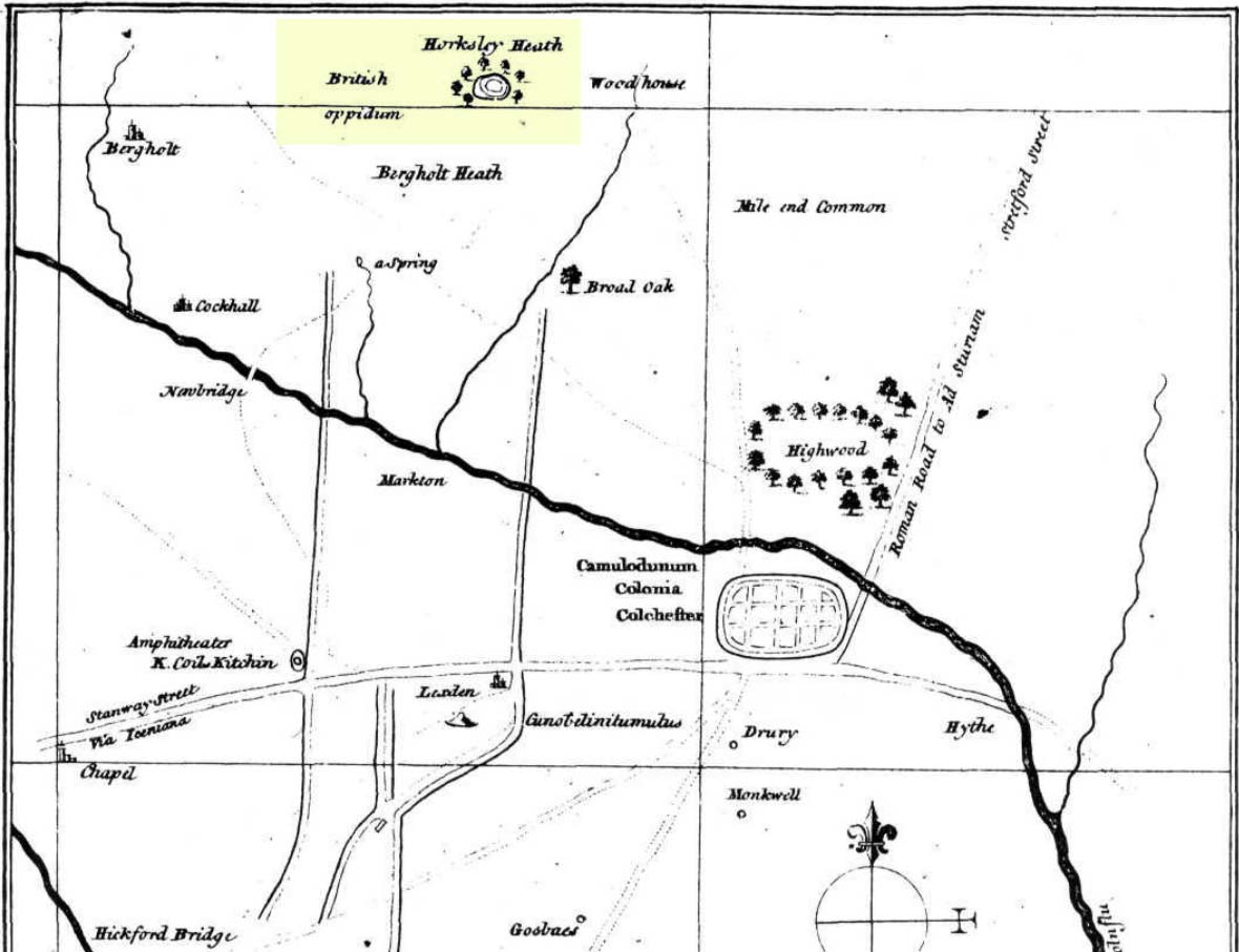
“…and so over Mott’s-bridge, and so cross the river by Nicholas Ayleward’s howse into the meadowe crossinge over to the lower ende of West-fielde, and from thence to Buttolph’s brooke leavinge the Brooke alwais upon the left-hand, and so along to Thomas Abrige (which is righte against Robin Hood’s oake). And from thence to Black-brooke under Chesterwelle and so along the Rampiers by Horkesley Heathe to the brooke that is under Langham-park-corner…”

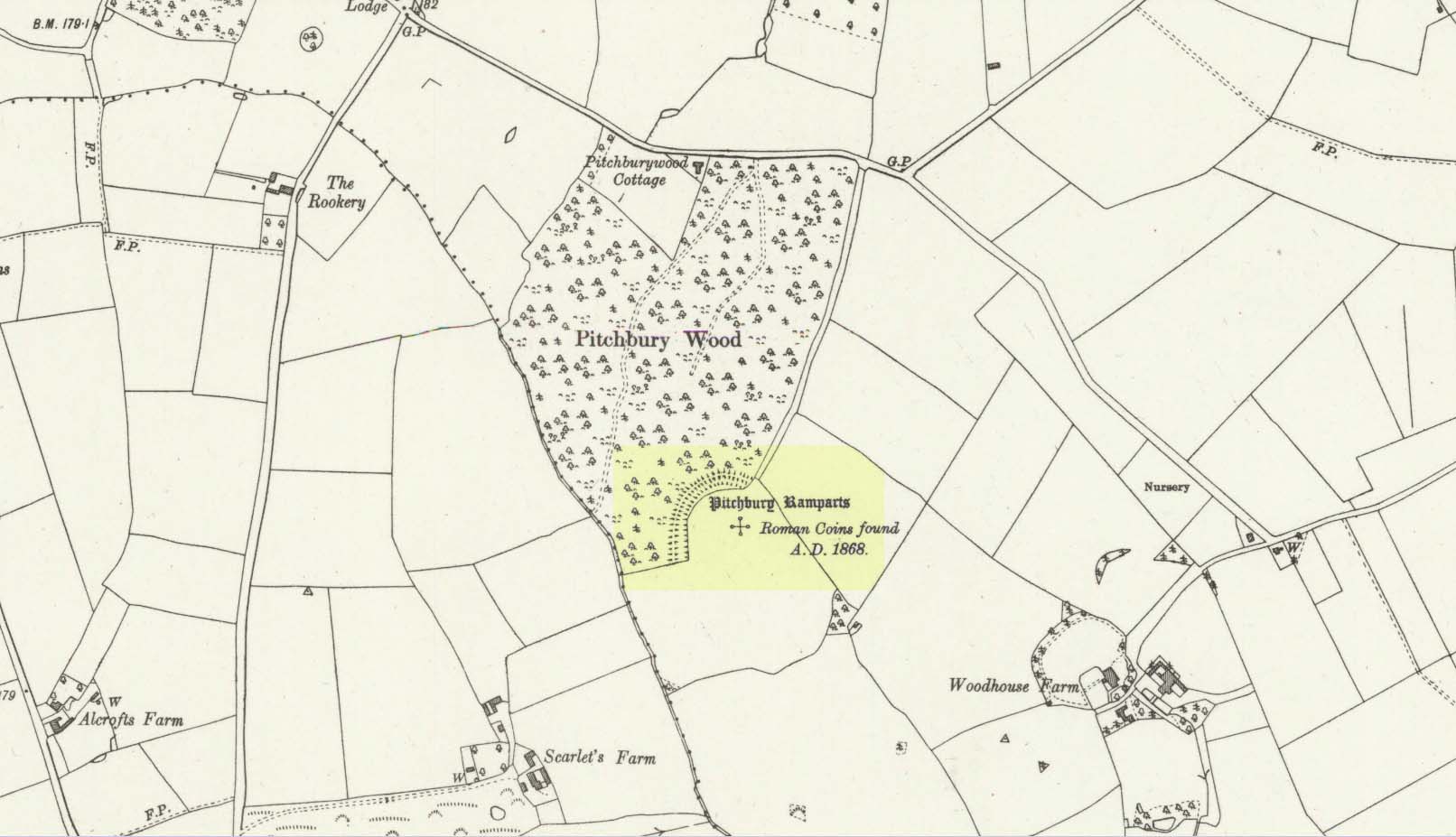
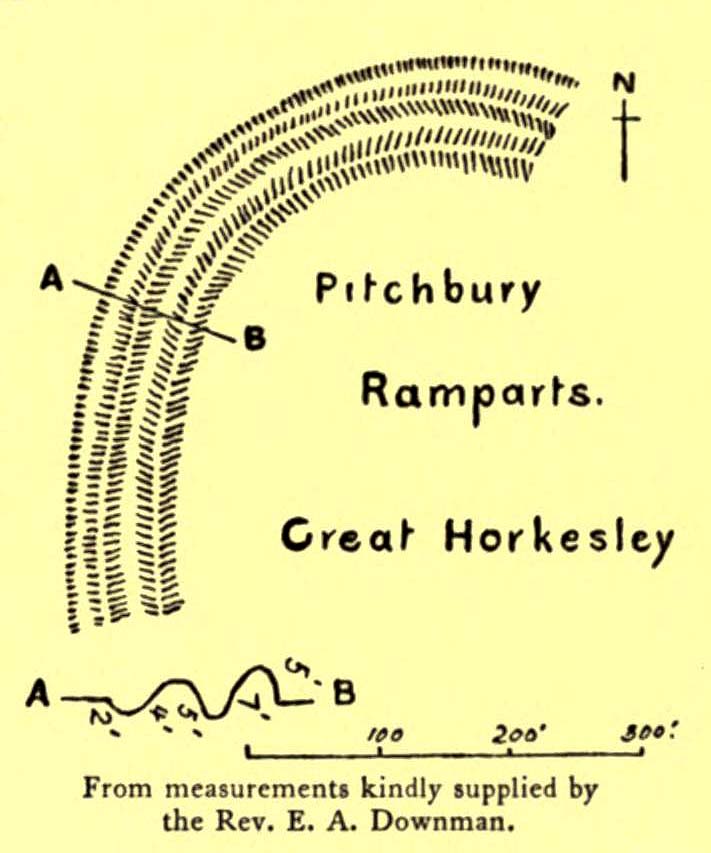
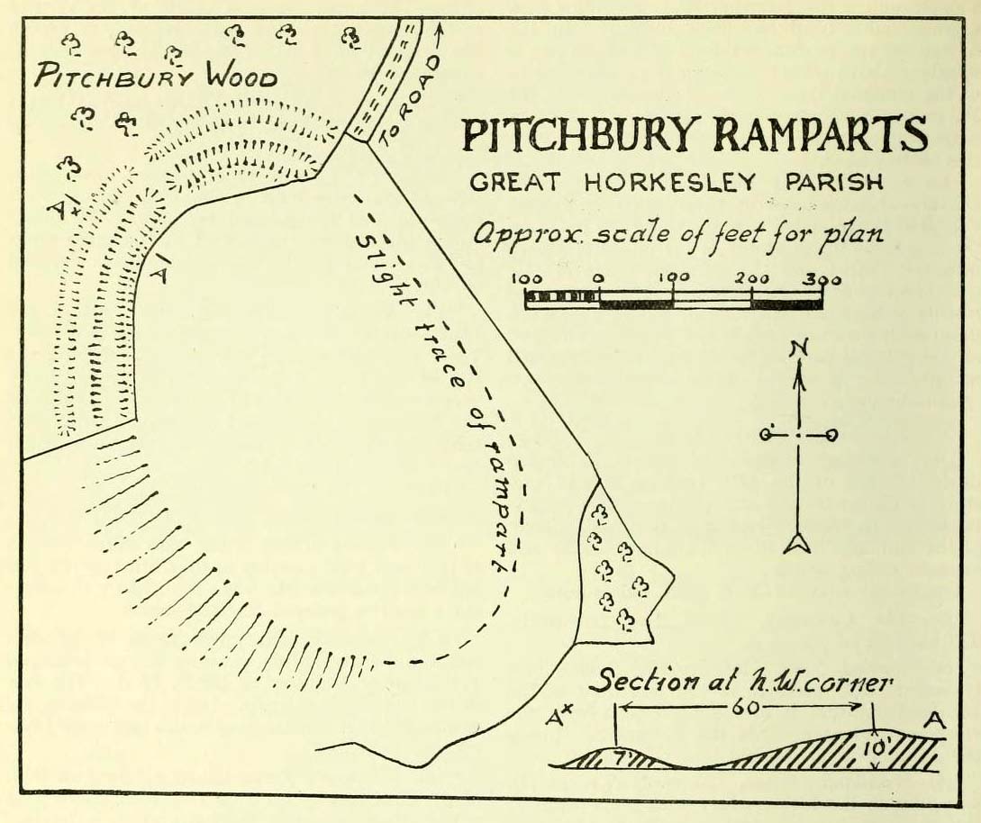
P.H. Reaney (1935) proposes that the ‘Rampiers’ in this account is the Iron Age hillfort of Pitchbury Ramparts.

The description of its whereabouts isn’t too clear, but in a subsequent and much longer perambulation account from August 1671, some extra topographical features are mentioned.  Starting not far from Mott’s Bridge, down Shett’s Hill to Newbridge,

“and then into the Fields in the occupation of Matth. Ayleward…through a gate a little above the Bridg: and soe along to Matth. Ayleward’s Yard, crosse the River into Matth. Ayleward’s Meadowe, and crosse that Meadowe into the lower part of Westfields, neare to which is a Foote-bridge cross the river, which is called Mott’s-bridge.  And soe along through West-fields to a Gate in a lane at or neere the north ende of a Meadow of one Mrs —, now in Samuel Duglet’s occupation, which lane parts West-fields from Bergholt, as the Parsons of each Parish, whoe were both present, affirmed; and, upon a Tree standing neere to which Gate is set a crosse.  And from thence to Butolph’s brooke, leaveing the brooke allwaies  upon the left-hand; and soe along through Mr Leming’s Meadows and Woods at the ende of them to a Bridge called Thomas Abridge, leading on to Horkesley Heath, which bridge is right against Robin Hood’s Oake, that stood on the pitch of the hill. And from thence along the Naylande Roade over Horkesley-heathe to Blackbrooke under Chesterwell, which Brooke runnes crosse the way at the foote of Horkesly cawsy…”

This second account seems to speak of the tree in the past tense, telling us that “Robin Hood’s Oake, that stood on the pitch of the hill”, but we can’t be completely sure.  I presume that there’s no longer any trace of this legendary oak tree; however, considering the fact that oaks can live to an incredible age, it may be worthwhile for a local antiquarian to follow this ancient boundary and see if, perchance, any remaining tree stump might still be there.  Y’ just never know…..

There are several other place-names in Essex relating to our mythical outlaw, including Robinhood End at Finchingfield described in 1699, and a farm of the same name nearby; plus a Robin Hood’s Inn near Loughton. (Reaney 1935)  There are probably a few more hiding away in field-name records…

NB:  The grid-reference map linked to this site is an approximation.  If someone can find the exact spot where the tree stood, we’ll update its position.   

References:

  1. Morant, Philip, The History and Antiquities of the Most Ancient Town and Borough of Colchester, W. Bowyer: London 1748.
  2. Reaney, P.H., The Place-Names of Essex, Cambridge University Press 1935.

© Paul BennettThe Northern Antiquarian

Pitchbury Ramparts, Great Horkesley, Essex

Hillfort:  OS Grid Reference – TL 9657 2906

Also Known as:

  1. Pitchbury Rings

Getting Here

Pitchbury site on 1924 map

Along the A134 in Horkesley Heath, turn west along Coach Road and after a half-mile where it veers right, keep going for another half-mile where you’ll reach the woodland on your left.  A path goes into the trees just before Pitchbury Lodge.  Go along here and near the very far (southern) end of the trees, just before the open fields, you’ll see the large undulating ramparts of earth.  Keep your eyes peeled.  You’ll see them!

Archaeology & History

Stukeley’s 1759 map

This once large hillfort was described in the Colchester township perambulations of 1671 and cited in Philip Morant’s classic work. (1748) He told how the boundary line ran “under Chesterwell along the Rampiers by Horkesley Heath,” and which P.H. Reaney (1935) tells was our wooded hillfort.  In Morant’s day, the place was all but complete and so would have been well recognised by local people.   Certainly it came the attention of the great antiquarian William Stukeley who, in 1759, came to Colchester and met with Morant.  Stukeley mainly surveyed the area south of here, at Lexden Heath, but one of his sketch maps clearly highlighted a place he called “a circular work on Horkesley Heath”, i.e., Pitchbury Rings.  The site seems to have remained relatively intact until the middle of the 19th century when a local land-owner took it upon himself to plough over and vandalise much of the site, leaving only a small proportion of the earthworks that we can still see to this day.

The ruins were described in I.C. Gould’s (1903) piece for the Victoria County History, where he told, at Great Horkesley,

Gould’s 1903 sketch of the remains
Royal Commission’s 1923 ground-plan

“are some remains of an earthwork known as ‘Pitchbury’ or ‘Pitsbury Ramparts.’  When the late Rev. Henry Jenkins described the camp in 1841, he stated that it was of oval shape, and contained about 6 acres.  Most of it was levelled for agricultural operations about fifty years ago, but there are still some remains, consisting of two banks with their accompanying ditches.  The lines moreover of that part which was destroyed, can be partially traced in the adjoining fields.”

When the Royal Commission (1922) doods wrote about the site nearly twenty years later, things hadn’t changed too much and they simply reported how the “ramparts have nearly disappeared, except for the north section.”  In this “imperfect” condition, as they called it, they gave the following brief description:

“Pitchbury Ramparts, in Pitchbury Wood, about 2 mile south of the church, are the north end of a large camp, roughly oval in shape, and defended by a double rampart and ditch.  The defences are well preserved in the wood, the inner rampart being 10 ft. above the ditch, which is 60ft wide from crest to crest, but the greater part of the work has been almost obliterated by the plough, and is now only faintly discernible in a large field S. of the wood.  The camp appears to have been 800 ft. long and 600 ft. wide.”

Thankfully there seems to have been no real increase in damage to the site since then.  It was excavated in some detail in 1933 and again in 1973 and the finds were published by the highly reputable Colchester Archaeological Trust, whose subsequent report by Hawkes & Crummy (1995) is required reading for anyone wanting to know the detailed archaeology of this and other sites in the area.

Folklore

An intriguing piece of folklore was described in John Round’s (1882) history of the early battles around Colchester Castle.  During the time when the Roman Empire was starting to crumble, the great Pictish tribes of Scotland ventured here and, we are told, took control of the Pitchbury Rings where they stayed before attacking Colchester Castle.

“Traces have been discovered of some violent catastrophe, possibly the first capture of the Colony by the marauding Picts from the North.  Allured, in one of their Southern raids, by the wealth of the goodly Colony, they swooped down like eagles on their quarry from the wooded heights of ‘Pictsbury’.”

References:

  1. Gould, I. Chalkley, “Ancient Earthworks“, in Victoria History of the County of Essex – volume 1, Archibald Constable: Westminster 1903.
  2. Hawkes, C.F.C. & Crummy, Philip, Colchester Archaeological Report 11 – Camulodunum 2, Colchester Archaeological Trust 1995.
  3. Hogg, A.H.A., British Hill-forts – An Index, BAR: Oxford 1979.
  4. Kemble, James, Prehistoric and Roman Essex, History Press: Stroud 2009.
  5. Morant, Philip, The History and Antiquities of the Most Ancient Town and Borough of Colchester, W. Bowyer: London 1748.
  6. Round, John H., The History and Antiquities of Colchester Castle, Benham 1882.
  7. Royal Commission Ancient Historical Monuments, England, An Inventory of Historical Monuments in Essex – volume 3, HMSO: London 1922.
  8. Reaney, P.H., The Place-Names of Essex, Cambridge University Press 1935.
  9. Watson, J.Y., Sketches of Ancient Colchester, Benham & Harrison: Colchester 1879.

Acknowledgements:  Big thanks for use of the 1st edition OS-map in this site profile, Reproduced with the kind permission of the National Library of Scotland

© Paul BennettThe Northern Antiquarian