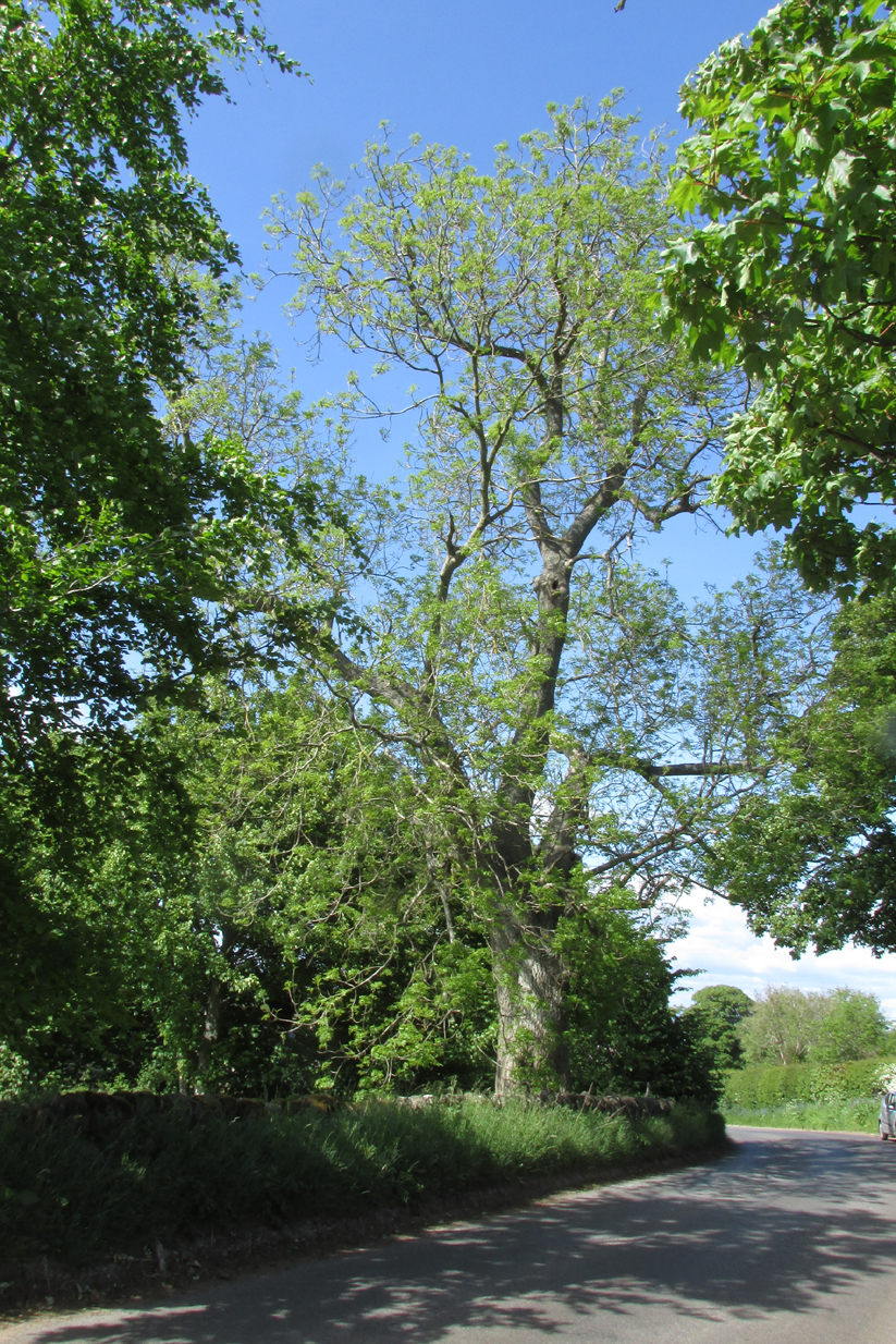
The tree is at Templeton on the west hand side of the Newtyle to Balkeerie Road travelling north, just before the bend in the road at Templeton Farm.
Archaeology & History
The only written record of the tree is in Strathmore Past and Present by the Reverend J.G. M’Pherson (1885):
Standing Proud
“After driving two miles eastward from the village of Newtyle along a most excellent level road, we enter the united parishes of Eassie and Nevay. The time-honoured boundary-mark is a conspicuous old ash, which popularly goes by the name of the Temple-tree. Tradition cannot guess its age. It is of considerable diameter, but quite hollow from the ground upwards for twenty feet. The bark is stripped off in several parts, and the thin shell of wood exposed is quite worm eaten; here and there being quite worn through, forming a rude door and rugged windows for the weird like interior.
“Large branches spread out, half dead-and-alive, with some foliage, scantily furnished with the life-giving root-sap. Could it speak it would tell of many a strange incident in its vicinity or underneath its arms. Its appearance might almost take one back to the time when the Templars left the neighbourhood; thus fixing its curious appellation”.
Sadly the tree described in the above quotation from 1885 has perished, but, just as it was not growing at the time of the Knights Templars’ local involvement, it is not unreasonable to speculate that it was a daughter of an ash tree that had formed a parish boundary marker of the original estate at the time of the Templars or even before. And now a daughter tree of that venerable 1885 tree grows in its place, the Temple-tree of the present day.
Various writers have attested to the Templar presence in Meigle, indeed M’Pherson writes:
“When the Knight Templars were in pomp…they had considerable interest in Meigle, several lands in the parish still being known as the Temple Lands. We prefer this derivation to the common one of templum, any religious house”.
In describing the now famous Meigle Pictish stones in the New Statistical Account, the Reverend William Ramsay (1845) writes;
“…A more satisfactory account of them has been suggested by Captain T.P. Mitchell, …He considers them as neither more nor less than the monuments of the Knights Templars, who unquestionably had a burying-ground at Meigle”.
While Mitchell was wrong in his attribution of the carved stones, he was clearly aware of the continuing memory of the Templars.
Modern research has shown that many of the Templar estates and lands in Scotland remained as separate fiscal entities within the Hospitaller lands up until at least the Reformation, which may explain the enduring Templar nomination of our tree.
Note: The tree formed the 19th century boundary of the parishes of Eassie and Nevay to the north, and Newtyle, both in Angus. We must assume the Templar lands boundary has been incorporated into the later parish system.
Note: This is not a clooty tree – please treat her with respect.
References:
Rev William Ramsay, Parish of Alyth, The New Statistical Account of Scotland, 1845.
Rev J.G. M’Pherson, Strathmore Past and Present, S. Cowan & Co: Perth, 1885.
Robert Ferguson, The Knights Templar And Scotland, The History Press: Stroud 2010
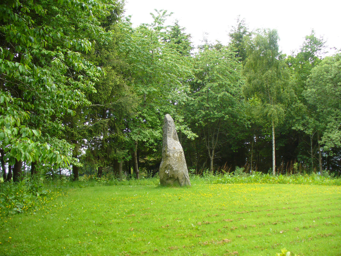
From the centre of Meigle village, you need to head along the country lane south-west towards the village of Ardler (do not go on the B954 road). About three-quarter of a mile (1.25km) along—past the entrance to Belmont Castle—you’ll reach a small triangle of grass on your left, where a driveway takes you into the trees. Walk down the drive and past the very first house—behind which is the stone in question. A small path takes you through the trees allowing you to get round to it. You can’t really miss it!
Archaeology & History
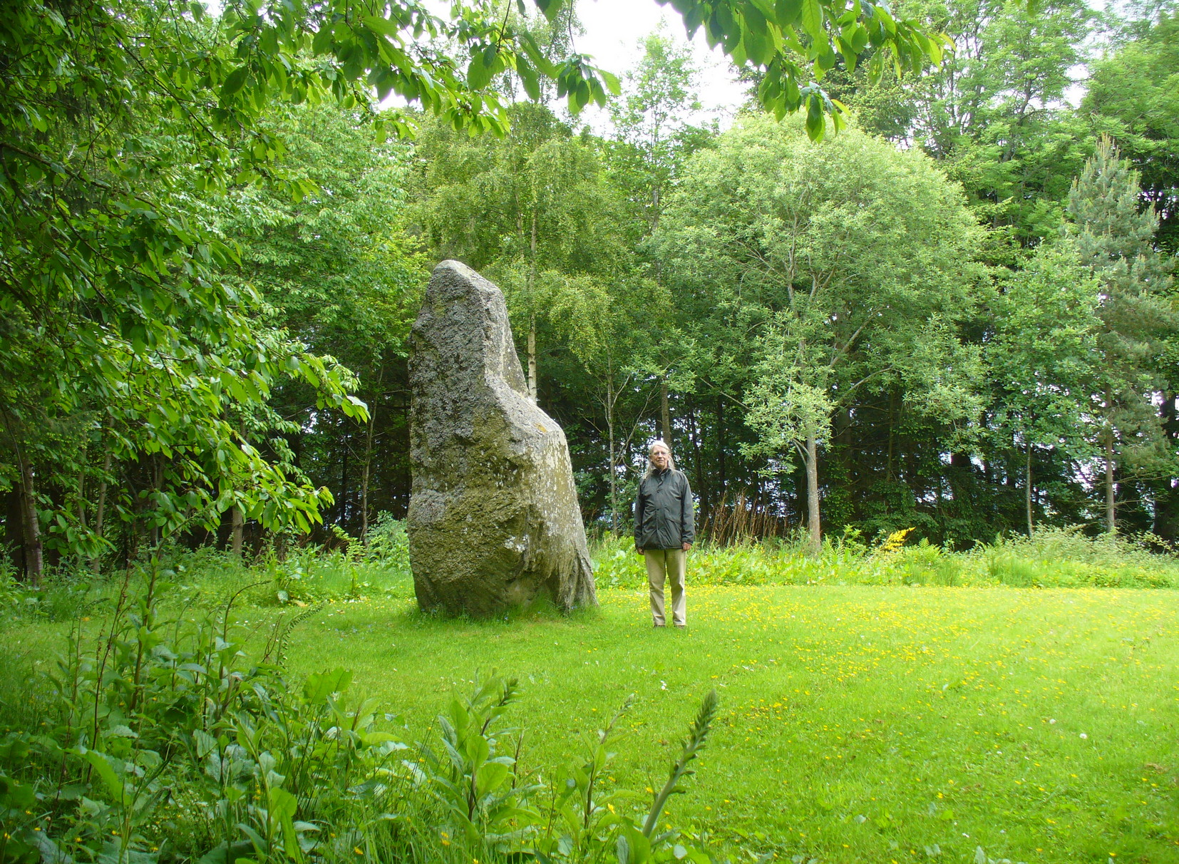
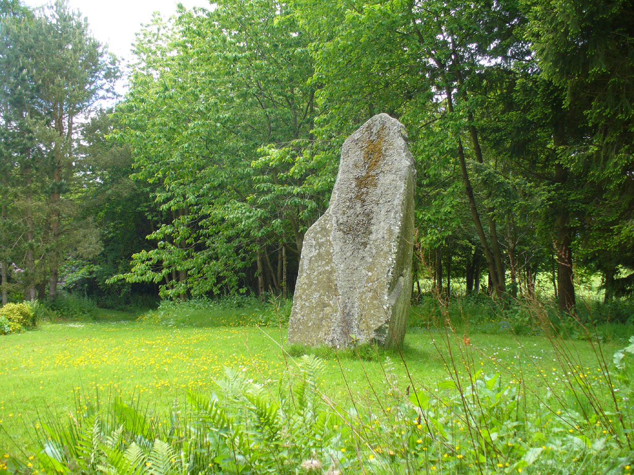
This is a magnificent site. A giant of a stone. Almost the effigy of a King, petrified, awaiting one day to awaken and get the people behind him! It has that feel of awe and curiosity that some of us know very well at these less-visited, quieter megalithic places. Its title has been an interchange between the Scottish King MacBeth and the witches who played so much in his folklore, mixed into more realistic local traditions of other heathen medicine-women of olde…
The first account of this giant standing stone came from the travelling pen of Thomas Pennant (1776) who, in his meanderings to the various historical and legendary sites of Meigle district, wrote that
“In a field on the other side of the house is another monument to a hero of that day, to the memory of the brave young Seward, who fell, slain on the spot by MacBeth. A stupendous stone marks the place; twelve feet high above ground, and eighteen feet and a half in girth in the thickest place. The quantity below the surface of the Earth is only two feet eight inches; the weight. on accurate computation amounts to twenty tons; yet I have been assured that no stone of this species is to be found within twenty miles.”
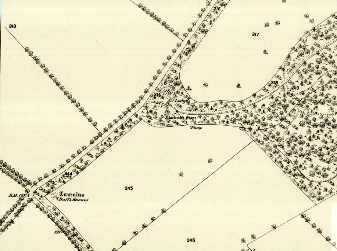
Site shown on 1867 map
A human & MacBeth!
It was visited by the Ordnance Survey lads in 1863, several years after one Thomas Wise (1855) had described the monolith in an article on the nearby hillfort of Dunsinane. But little of any substance was said of the stone, and this is something that hasn’t changed for 150 years, despite the huge size of this erection! Local historians make mention of it in their various travelogues, but the archaeologists haven’t really given the site the attention it deserves. Even the Royal Commission (1994) report was scant; and apart from suggesting it to have a neolithic provenance, they merely wrote:
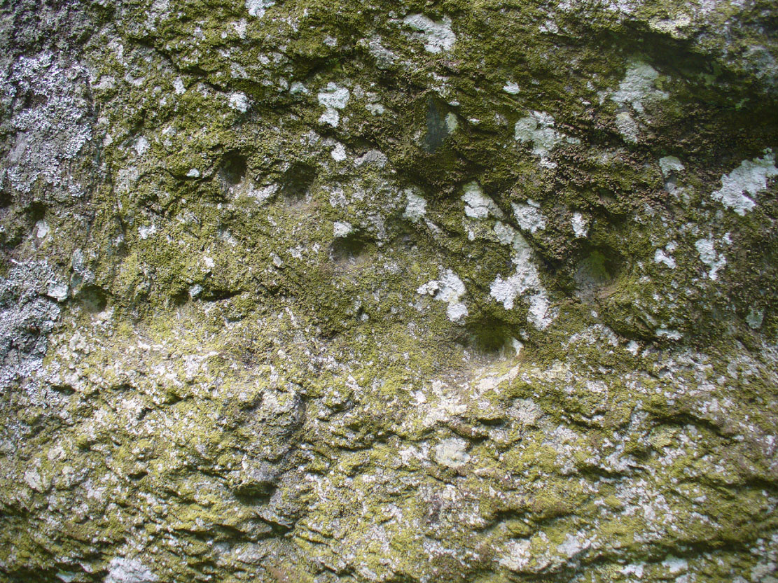
“Rectangular in cross-section, the stone tapers to a point some 3.6m above the ground; each of its sides is decorated with cupmarks, as many as forty occurring on the east face and twenty-four on the west.”
East face of MacBeth
MacBeth Stone (Wise 1884)
Thankfully, the fact that there are cup-markings on the stone has at least given it the attention it deserves amongst the petroglyph students. The first account of the cup-markings seem to have come from the pen of Sir James Simpson (1867) who mentions them, albeit in passing, in his seminal work on the subject. A few years later however, the same Thomas Wise visited MacBeth’s Stone again, and not only described the carvings, but gave us our first known illustration in his fascinating History of Paganism (1884). He told it to be,
“A large boulder, some 12 tons in weight, situated within the policies of Belmont Castle, in Strathmore, Perthshire…is supposed to have been erected on the spot where MacBeth was slain. Two feet above the ground this boulder has a belt of cups of different sizes, and in irregular groups. None of these cups are surrounded by incised circles or gutters. This boulder was probably intended for some sacred purpose, as it faces the SE.”
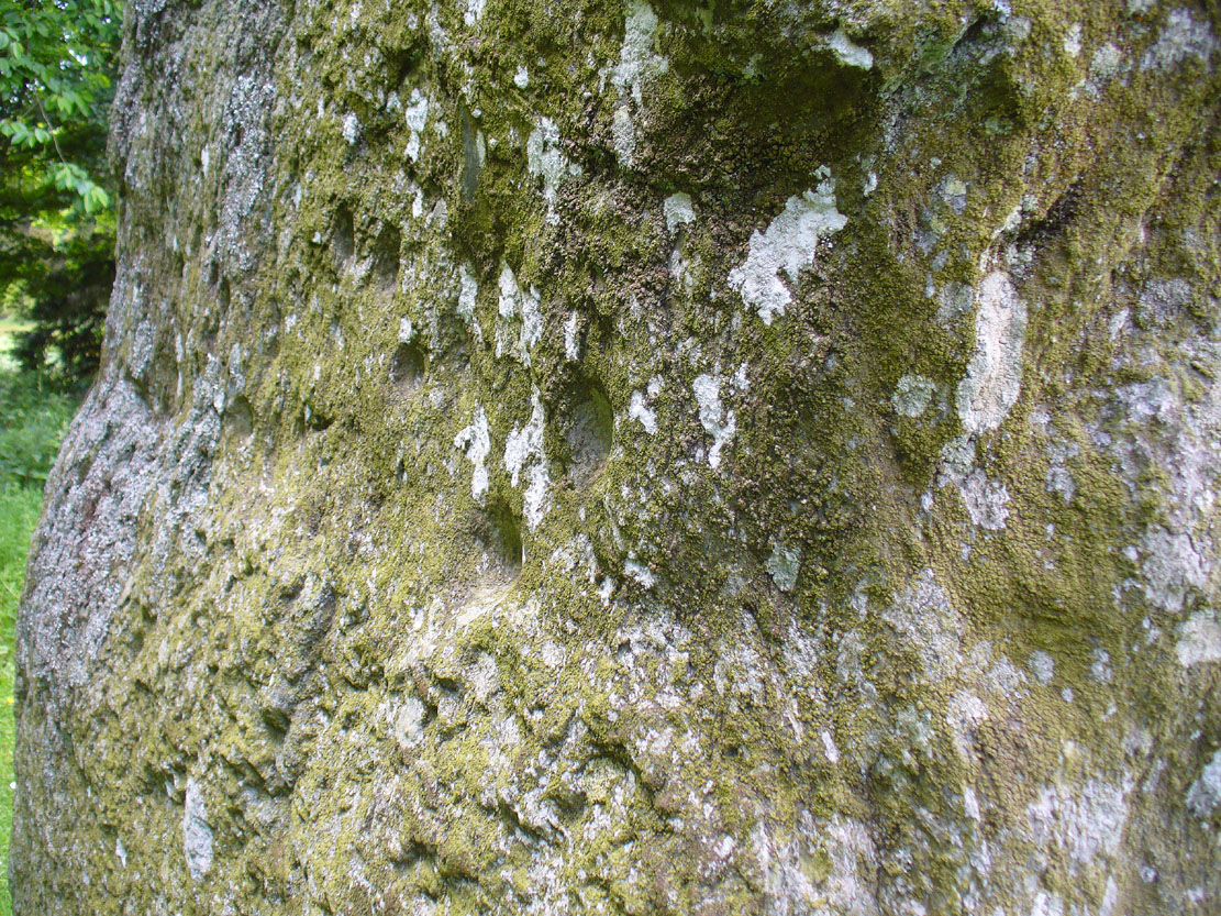
Running almost around the middle of the standing stone, on all four sides, are the great majority of the cup-markings (no rings or additional lines are visible). They were very obviously etched into the stone after it had been erected, not before. This is in stark contrast to the cup-and-rings found on the standing stones at Machrie, Kilmartin and elsewhere, where we know the carvings were done before the stones were stood upright.
Cup-marks on west side
Cup-marks on west face
On the northern face of the stone is one possible cup-marking, and three of them are etched onto its south face; but the majority of them, forty, are on its western face, and twenty-five on its eastern side. The great majority of them on the east and west sides occur roughly in the middle of the stone, almost like a ‘belt’ running across its body. Those on the eastern face are difficult to discern as a thick layer of lichens covers this side, so there may be even more beneath the vegetation.
One of the notable features of the monoliths across this region, and echoed again here, is that one side of the standing stone is smooth and flat—and here in the case of MacBeth’s Stone, the flat face is the eastern one. Whether this feature was deliberately intended (it seems to have been) and what it might imply, we can only guess. It might simply relate to the geophysics of the stone, making it easy to crack horizontally….
The ‘face’ in the top of the stone
Close-up of Macbeth’s face
Another fascinating feature at this site was noticed by Nina Harris of Organic Scotland. Meandering around the stone in and out of the trees, she called our attention to a fascinating simulacra when looking at the upper section of the stone on its southern side. At first it didn’t seem clear – but then, as usual, the more you looked, the more obvious it became. A very distinct face, seemingly male, occurs naturally at the top of the stone and it continues as you walk around to its heavily cup-marked western side. It’s quite unmistakable! As such, it has to be posited: was this simulacra noticed by the people who erected this stone and seen as the spirit of the rock? Did it even constitute the reason behind its association with some ancestral figure, whose spirit endured here and was petrified? Such a query is neither unusual nor outlandish, as every culture on Earth relates to such spirit in stones where faces like this stand out.
But whatever your opinion on such matters, when you visit this site spend some time here, quietly. Get into the feel of the place. And above all, see what impression you get from the stony face above the body of the stone. Tis fascinating…..
Folklore
Known locally as being a gathering place of witches, the site is still frequented by old people at certain times of the year, at night. The stone’s association with MacBeth comes, not from the King himself (whose death occurred many miles to the north), but one of his generals. In James Guthrie’s (1875) huge work on the folklore of this region, he told that this giant
“erect block of whinstone, of nearly twenty tons in weight…(is) said to be monumental of one of his chief officers”,
which he thought perhaps gave the tale an “air of probability about it.” But Guthrie didn’t know that this great upright was perhaps four thousand years older than the MacBeth tradition espoused! However, as Nick Aitchison (1999) pointed out in his singular study of the historical MacBeth,
“another MacBeth was sheriff of Scone in the late twelfth century and it is possible that he, and not MacBeth, King of Scots, is commemorated in the name.”
He may be right. Or it the name may simply have been grafted onto the stone replacing a more archaic relationship with some long forgotten heathen elder. We might never know for sure.
When Geoff Holder (2006) wrote about the various MacBeth sites in this area, he remarked that the folklore of the local people was all down to the pen of one Sir John Sinclair, editor of the first Statistical Account of the area—but this is a gross and probably inaccurate generalization. Nowhere in Holder’s work (or in any of his other tomes) does he outline the foundations of local people’s innate subjective animistic relationship to their landscape and its legends; preferring instead, as many uninformed social historians do, to depersonalise the human/landscape relationships, which were part and parcel of everyday life until the coming of the Industrial Revolution. Fundamentally differing cultural, cosmological and psychological attributes spawned many of the old myths of our land, its megaliths and other prehistoric sites. It aint rocket science! Sadly, increasing numbers of folklore students are taking this “easy option” of denouncement, due to educational inabilities. It’s about time researchers started taking such misdirected students to task!
References:
Aitchison, Nick, MacBeth – Man and Myth, Sutton: Stroud 1999.
Coutts, Herbert, Ancient Monuments of Tayside, Dundee Museum 1970.
Royal Commission on the Ancient & Historical Monuments of Scotland, South-East Perth: An Archaeological Landscape, HMSO: Edinburgh 1994.
Simpson, James, Archaic Sculpturings of Cups, Circles, etc., Upon Stones and Rocks in Scotland, England and other Countries, Edmonston & Douglas: Edinburgh 1867.
Acknowledgements: With huge thanks to Paul Hornby for his help getting me to this impressive monolith; and to Nina Harris, for prompting some intriguing ideas.
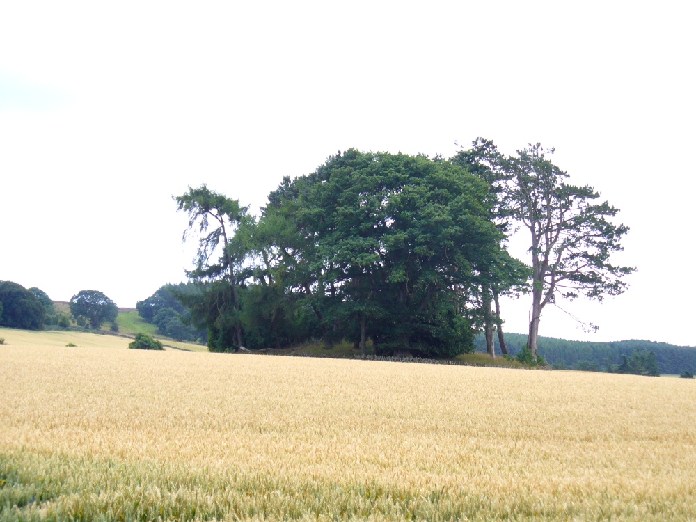
From the large village of Newtyle, take the straight road west as if heading to Kettins. About half-a-mile along, 100 yards or so past the turn-off to Kinpurnie Castle on your left – stop! In the second field after the turn-off, halfway up the slope you’ll see a large circular rise in the land with a crown of large trees sitting thereon. That’s the cairn!
Archaeology & History
Not far from the impressive Keillor standing stone is this huge prehistoric tomb. Measuring about 90 feet across and more than 7 feet high in places, the mass of rocks making up the site is now crowned by a healthy ring of trees. Near the middle of it you can see a collapsed tomb or cist, but there may be more than one inside this giant fella. Its size implies that it was a tomb or burial centre for tribal elders, leaders or shamans. When we visited the site last week, the field was still in full crop, so we couldn’t take a close look at it and must return again at a later date. Apart from a brief note of the site in the Royal Commission (1983) archaeology listing for the county, no details have been made of this huge cairn—which is incredible in itself!
References:
Royal Commission on the Ancient and Historical Monuments of Scotland, The Archaeological Sites & Monuments of Central Angus, Angus District, Tayside Region, HMSO: Edinburgh 1983.
Take the minor road that runs from the small town of Newtyle (in Angus) westwards to Kettins (in Perthshire). Less than a mile on, go up the first turn-off on your left to Kinpurnie Castle and continue (past the castle) for less than a mile. Keep your eyes peeled on the right-hand side of the road, opposite the drive to High Keillor – and you can’t really miss it!
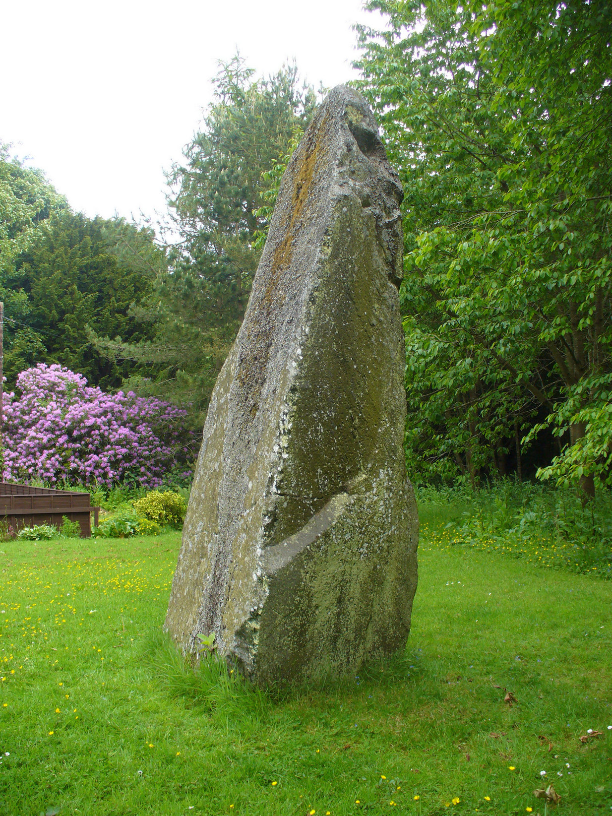
Archaeology & History
Another feel of Keillor’s Stone
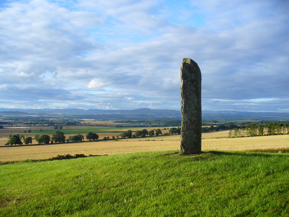
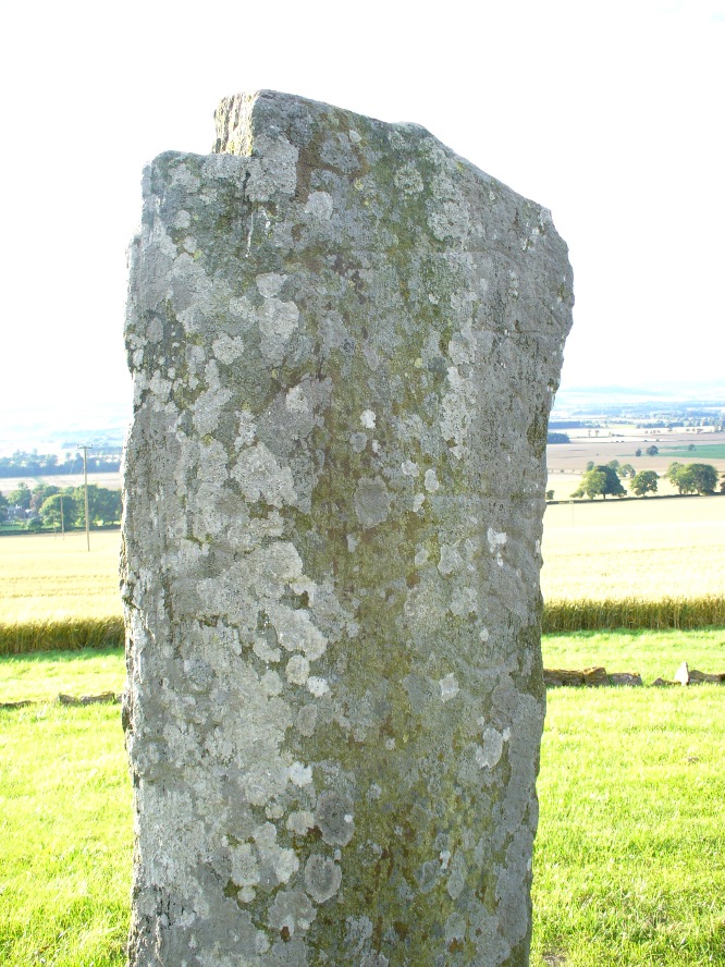
A fascinating site in an excellent setting. Here we have a 6-7 foot tall standing stone living upon a what is most probably a Bronze Age tumulus (possibly neolithic, but we aint sure), on whose south-face were carved a series of Pictish symbols many many centuries ago. In the surrounding district there is a vast wealth of similar sites (and many destroyed, like the lost Hill of Ballunie stone circle only a few hundred yards along the road), highlighting that this region was very important indeed to the prehistoric peoples of Strathmore and the Sidlaw Hills.
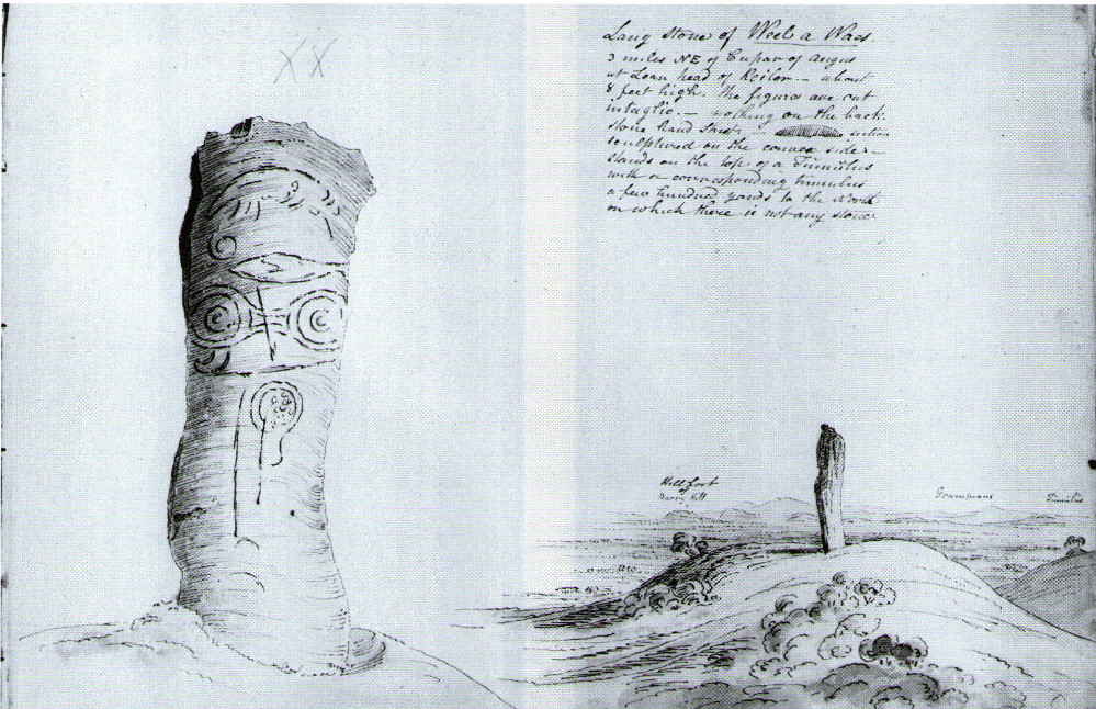
W.J. Skene’s 1832 drawing
The Keillor stone was described and illustrated by several of the giant Scottish antiquarians. When James Skene visited the site in the 1830s, the tumulus upon which the stone stands was still pretty complete, as his old drawing from 1832 clearly shows. Since then the track beside the monument has widened and the road took away half of the burial mound. But the place has lost little of its majesty.
Another 19th century historian, William Oliphant (1875), when describing the beauty and history of the Sidlaw Hills, below whose edges the old hamlet of Keillor stands, told of this,
“old and striking monument, making the spot on which it stands historical, though no syllable of the history has come down to us. It is, one writer says, “one of those remarkable sculptured monuments of the ancient inhabitants of Scotland, embellished, in this instance, with the rude outline of the boar.” Another writer says, “at Baldowrie there is an erect Danish monument six feet high. It contains some figures, but they are almost entirely defaced.”
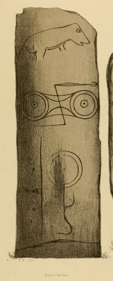
In John Stuart’s (1856) superb magnum opus he told that this carved pillar with “a boar” on it, standing on an ancient “tumulus of earth and stones” was found to have evidence of several burials inside when a dig at the site occurred which, he told, “I was present (at) in the autumn of 1854.” He described the site as follows:
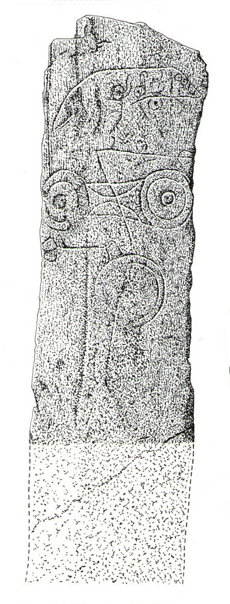
Stone with carved symbols (after RCAHMS 1994)
Stuart’s 1854 drawing of the carved stone
“The Stone at Keillor is placed on a tumulus on the north slope of the Hill of Keillor, in the Parish of Newtyle, and Shire of Forfar. It is a rough stone, formed of gneiss, convex in front, and rugged behind. The tumulus on which it is placed is formed of earth and stones, and several cists containing bones have been found in it. Ancient sepulchral remains have also been dug up in various parts of the adjoining field.
“The stone was broken across some years ago about a foot above the ground, but the parts have recently been clasped together, and the stone replaced in its original site by orders of Lord Wharncliffe. The present drawing was made with much care by Dr. Wise, and is more perfect than the copy in Mr. Chalmers’ volume. The surface of the stone is so rough, that it is sometimes with difficulty that the incised lines can be satisfactorily distinguished from natural fissures, but having examined the stone in a variety of lights, and compared Dr. Wise’s sketch with the original, I am inclined to think that the drawing is as satisfactory as can now be obtained. There is a rough sketch of the stone among Dr. Hibbcrt’s papers, with a supposed Gaelic inscription at the top, meaning “the burying place of the slain,” furnished to Dr. Hibbert by the late Mr. Donald Gregory. Of such inscription 1 could see no trace.”
The old stone himself
Faint carvings just visible
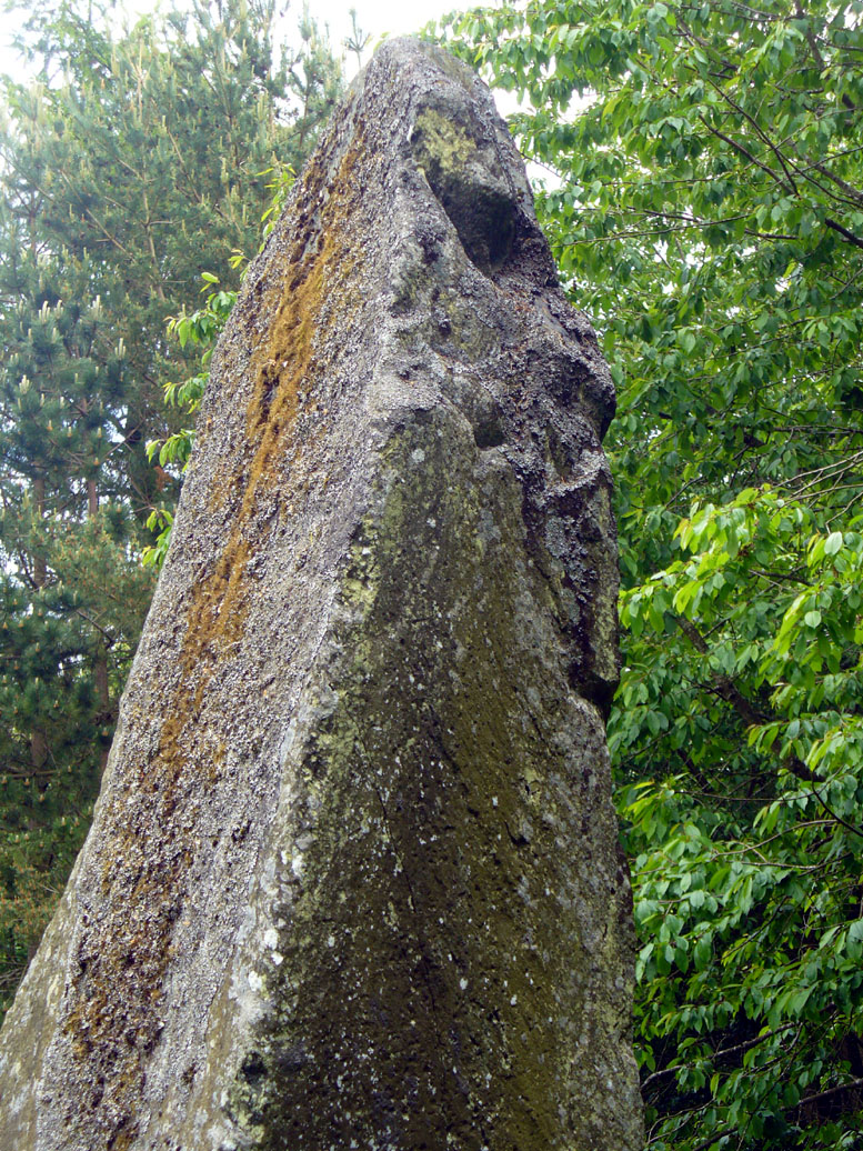
And as far as I am aware, this Gaelic inscription has not subsequently been recorded. But considering the position of the stone in the landscape, it’s understandable if some of the carvings have eroded away by simple weathering. Indeed, when Paul Hornby and I visited here only a couple of weeks ago, despite the weather conditions being excellent, the carvings were difficult to make out. Modern interpretations differ between the topmost animal carving being either a wolf or a boar. Below this we see the more common Pictish symbol described as a double disc and Z-rod symbol, for which academia still struggles to afford cogent explanations.
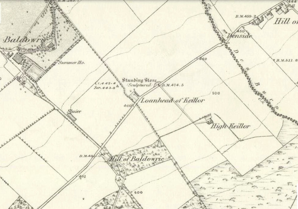
Keillor stone on 1865 map
Whilst the prehistoric age of the tumulus on which this stone stands is not in doubt, we don’t know exactly when this stone was first erected here. Whilst some of the early accounts—including the Ordnance Survey team who first visited here in 1860—describe it in an upright position, when A.J. Warden (1880) wrote about it in his massive survey of the region, he noted that wasn’t always the case:
“On the north slope of the Hill of Keillor, in the parish of Newtyle, there is a rough stone composed of gneiss, somewhat convex in front but rugged behind. It is placed on a tumulus formed of earth and stones, and several cists containing bones were found in it; while, in the adjoining field, ancient sepulchral remains have also been found. The stone was broken across about a foot from the ground, but the parts have been again united and the stone replaced on its original site. On the stone there is the figure of an animal, below which are the spectacle and other symbols, all incised.”
The stone presently stands on a modern plinth to protect it from the elements and such things. It was erroneously described in the Royal Commission’s 1999 survey of Pictish monuments as being just “1.4m in height”, whereas it is in fact some 6½ feet tall, or around 1.98m.
The Great Pyramid to the northwest
The view from here, east, north and west is superb. The high rolling hills of Angus stretch into the north and eastern skies; whilst more westerly are the grand olde mountain ridges into deepest Perthshire. And looking northwestwards from our old standing stone, one shapely mountain in particular is notable, standing out upon the ridge of distant hills: a great pyramid which I initially thought may have been Ben Vorlich. But thanks to the help of several local people, have found that it is in fact Schiehallion – the great Mountains of the Fairy Folk, about 50 miles away! Some folk think that it may have had relevance in the animistic formula with this monument—and I’ll hazard that it did too…
…to be continued…
References:
Allen, J. Romilly, Early Christian Monuments of Scotland, 1903.
Coutts, Herbert, Ancient Monuments of Tayside, Dundee Museum 1970.
Guthrie, James C., The Vale of Strathmore – Its Scenes and Legends, William Peterson: Edinburgh 1875.
Jervise, Andrew, Epitaphs and Inscriptions from Burial Grounds and Old Buildings in the North-East of Scotland – volume 1, Edmonston & Douglas: Edinburgh 1875.
Mack, Alastair L., Field guide to the Pictish symbol stones, Pinkfoot Press 1997.
MacPherson, J.G., Strathmore: Past and Present, S. Cowan: Perth 1885.
Marshall, William, Historic Scenes of Forfarshire, William Oliphant: Edinburgh 1875.
Royal Commission on the Ancient & Historical Monuments of Scotland, South-East Perth: An Archaeological Landscape, HMSO: Edinburgh 1994.
Royal Commission on the Ancient & Historical Monuments of Scotland, Pictish Symbol Stones: A Gazetteer, Edinburgh 1999.