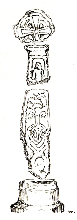
As with many old churches, St. James’ at the northern side of the village has remains of old cross fragments that can be seen inside. They were described at some length in W.S. Calverley’s (1899) excellent work on such monuments. Mr Langham (1972) also gave a good account of the respective cross fragments in his short work on this history of the church, listing the sections as a, b, c, d and e. He wrote:
“a) the greater part of a wheel-head, the reverse side of which has a sunk centre instead of a raised boss, making it a five hole cross. Calverley remarks, “a rarity in the district.”
“b) probably the top of a shaft having on its face a panel with a defaced figure, and conventional ornaments on the side.
“c) probably the lower part of a shaft with figures in two panels, and with incised interlacing designs on the reverse side “of late Scandinavian type, resembling fibulae of the Viking Age.” On the face, the lower panel is Christ risen or rising from the tomb. He is trampling on a serpent and carries a palm of victory in his left hand. The panel above has two figures, suggested by Calverley to be “either John or Mary, or two angels.”
“d) the neck of a cross. Calverley notes that the execution of the wheel-head and the shaft-fragments was by a hacking not a chiselling method, and he makes the comment: “The shafts and head at Burton are similar in workmanship to those at Halton. The Halton crosses and not Norse in style, but are like late pre-Norman work in Yorkshire, where the Danes lived.”
“e) a part of a second shaft with a zigzag pattern. Calverley says that “it is neatly chiselled, and the designs suggests a Norman date, although it seems to belong to a cross of Saxon type.” The Royal Commission volume dates it as the 10th or 11th century.”
St James church cross (by M.D.S. Brown-Smith)
The Royal Commission volume dates the cross shafts as “probably late 10th century.” Sir Nikolaus Pevsner in a recent book, Guide to Cumberland and Westmorland states specifically that, “Christ, the Virgin and St. John are on the Burton-in-Kendale cross.” This is too explicit a statement in view of the deterioration in the detail.
Nearby to the northeast used found to be the remains of a holy well dedicated to St. Helen. Does anyone have further information about it?
References:
Calverley, W.S., Notes on the Early Sculptured Crosses, Shrines and Monuments in the Early in the Present Diocese of Carlisle, T. Wilson: Kendal 1899.
Langham, John G., Parish Church of St. James, Burton-in-Kendal, Mayoh Press: Carnforth 1972.
Take the B6246 road northwest out of Whalley, or else east from Hurst Green, until you hit the little village of Great Mitton, with its churchyard in the middle. Go into the churchyard and you’ll find this weird-looking cross!
Archaeology & History
The curious-looking upright in the churchyard here has a mixed history by all accounts. The oldest portion of the cross is universally ascribed to be the top section, rediscovered when it was dug up “shortly before 1801.” (Ackerley 1947) It possesses a carving of the crucifixion on one side, and some curious figures carved on the other, which some ascribe to being Jesus, but could well be the triple female element which would still have been prevalent in peasant culture at the time it’s thought to have been carved. The original shaft carrying the ‘cross’ had long since been destroyed and so, according to Jessica Lofthouse (1946),
“In 1897 it was ‘re-erected to commemorate the 1300th anniversary of the reintroduction of christianity into Britain,’ with the new shaft we see today. This is the oldest relic in Mitton.”
In J. Buckler’s early 1841 drawing of both sides of the carved cross-head we can see in greater detail the nature of the medieval rock art and this was described in Aymer Vallance’s (1920) decorative analysis of carved crosses in England. He told that
“the cross-head at Mitton, Yorkshire…is peculiar inasmuch as the crucifixion is sculptured on both faces, but in totally different fashions. That on the west face has the arms stretched horizontally, within a sexfoil frame, and might well be of the thirteenth century. Whereas the sculpture on the east face, though much more weatherworn, is of a style that could not have been designed before the fourteenth, or perhaps even the fifteenth century. The arms of the Christ in this instance are drawn upwards in an unusually oblique direction. It is impossible that these two representations could have been executed at one and the same date. The circular outline of the head, too, is peculiar, and suggestive rather of a gable-cross than of a standing cross. Possibly the west face only was sculptured in the first instance, for a gable-cross, the sculpture on the east face being added later in order to adapt the stone for the head of a churchyard cross.”
Although I’ve gotta say that the three carved figures with the upright arms strikes me more as three females than any crucified character and may be an early depiction of the three Mary’s.
One of the early ministers at Mitton church was none other than John Webster, who wrote the highly influential work, Displaying of Supposed Witchcraft, which denounced much of the Church’s obsession and murder of countless people under the auspice of some spurious devil and demonological bollocks which, even today, some still suffer to endure. Webster was only at Mitton for a few years, before moving into deeper Yorkshire and setting up at Kildwick.
References:
Ackerley, Frederick George, A History of the Parish of Mitton, Aberdeen University Press 1947.
Lofthouse, Jessica, Three Rivers, Robert Hale: London 1946.
Vallance, Aymer, Old Crosses and Lychgates, Batsford: London 1920.
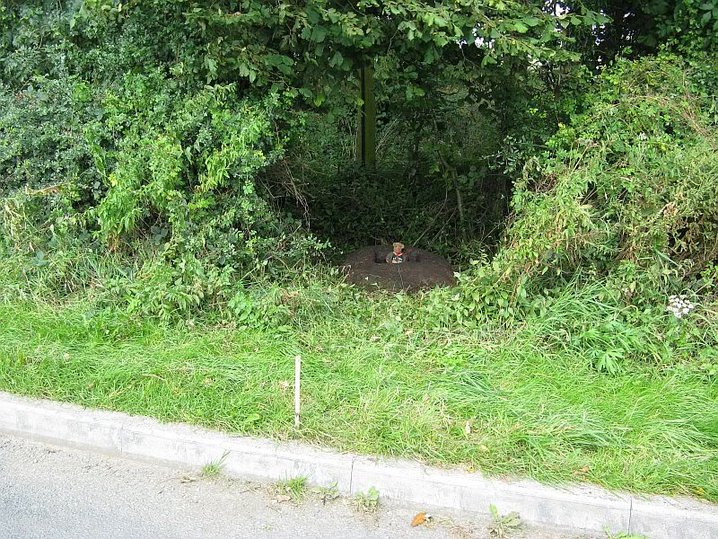
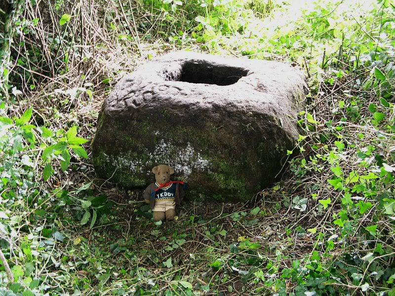
From Great Mitton village, go up (north) the slightly winding B6243 road for a mile, then take the left turn up the minor country lane, for about 300 yards, till you reach a tiny crossroad of tracks, one leading down to Scott House and the other up to Withgill Farm. Stop here! You’re damn close. From what our man ‘QDanT’ says, this is now to be found behind the hedge by the roadside, on the side of the road where the track runs up to Withgill Farm, tucked low and overgrown close to the ground. Good luck!
Archaeology & History
Described by Mr Ackerley (1947) as being found
“in the coppice beside the gate to Withgill is the base of another road-side cross,”
Cross-base (after QDanT)
all but overgrown by ivy and lost to the causal eye. Thankfully our man Danny got on his bike and found the remains of the little fella, all-but invisible beneath the vegetative growth! Beneath the vegetation, John Dixon told there to be “some interesting 17th century graffiti,” but there’s not much that remains of the old cross.
Folklore
There is a curious story about a legendary church that was once supposed to have been up the track on the hill just above here at the farm. The story goes,
“that when Mitton church was built, it ought to have been built on Withgill Knowle: that there was a church somewhere about there, and that the stones from it were carted down to Mitton in one night and used in building the present church.”
This bitta folklore is a motif found commonly at prehistoric sites, where stones from our ancient places were uprooted and moved (destroyed) to give way to the new christian mythos. To my knowledge, no such prehistoric sites are known hereby. Mr Dixon – over to you dear sir!
References:
Ackerley, Frederick George, A History of the Parish of Mitton in the West Riding of Yorkshire, Aberdeen University Press 1947.
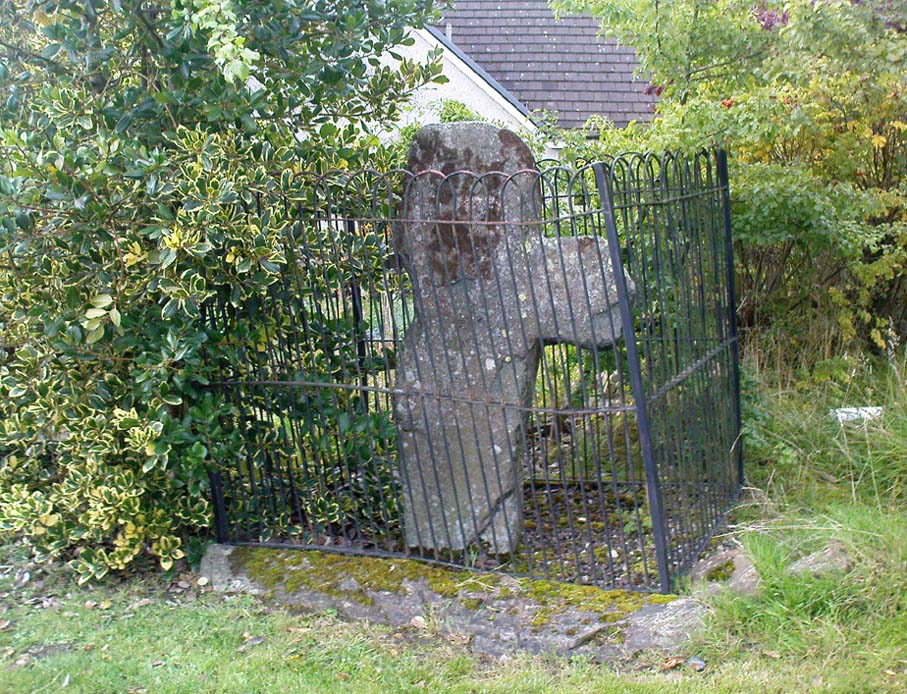
From Aberfeldy, take the B846 road over the river bridge, past Weem, a couple of miles down the valley until you see the small road on the right which leads up to the ancient hamlet of Dull. Go up and round the corner until you reach the centre of the village; and here the road turns back downhill. At this point, right by the roadside, entrapped within old railings, you’ll see the Cross of Dull.
Archaeology & History
Dull Cross behind bars
Standing more than three feet tall, the remains of this old cross with one of its extended arms broke off in previous centuries, was one of three such monuments that used to stand in the valley. This and its associates were, according to christian legend, placed as markers at an ancient centre of christian learning at Dull around the time of Adamnam (who died in Glen Lyon in 704 AD). The area was said to be an early druid college, which was later incorporated into early christian teachings. Hilary Wheater (1981) also told that in previous centuries, if anyone fell foul of the law,
“Within the boundaries of these crosses debtors, offenders or miscreants were protected from retribution. One of the crosses stands in the centre of Dull village to this day, having been used as a market cross in more recent times, and the other two, having been stolen for use as gateposts during the (19th) century, were placed in the old kirk at Weem for safety.”
References:
Stuart, John, The Sculptured Stones of Scotland, Aberdeen 1856.
Wheater, Hilary, Aberfeldy to Glenlyon, Appin Publications: Aberfeldy 1981.
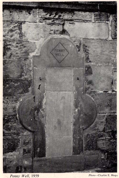
The stone marking the position of the well is situated on the north side of the road at the east end of Grange Loan, a few yards west of the junction with Findhorn Place, at Newington on the south side of Edinburgh. Unfortunately, all that now remains of the well is a red sandstone front with two pieces of metal on each side.
Archaeology & History
Set back a little into the wall alongside the road, we today see only the architectural memory of this once famous and much-reputed holy well, whose waters sadly no longer flow. Curiously omitted from the primary Scottish surveys on holy wells, it was long known as an important water source by the people of Edinburgh in ages past. The best article on the site was written by W.F. Gray (1962) some fifty years ago, in which he told:
“Built against a garden wall, the Penny Well looks rather forlorn. Now that a plentiful supply of water is in every dwelling, its public usefulness is definitely at an end, though it may slake the thirst of a passer-by. But however that may be, the Penny Well has a long if not distinguished history, though fact and fiction, it is to be feared, are inextricably linked.
“And first, as to its age. There is documentary evidence of the existence of the Penny Well as far back as 1716. In that year Sir William Johnston of Westerhall, Dumfriesshire, disposed to William Dick of Grange three acres of his lands of Sciennes, which are described as bounded on the west by the lands belonging to “said William Dick and the Penny Well.” The well really marked the south-east boundary of the lands of Grange.
“The actual age of the Penny Well is unknown. All that can be positively stated is that it has existed for at least two hundred years… How the Penny Well came by its name is another unsolved mystery. There is a story to the effect that in the earlier half of the nineteenth century an old woman who lived in the cottage opposite the well had charge of the spring and sold the water to wayfarers at a penny a glass. A very plausible story by which to account for the name! Unfortunately its credibility is shaken by the fact that…the spring was known as the Penny Well fully a century before…
“Sir Thomas Dick Lauder, when he took up residence at Grange House in 1832, was deeply interested in the well at the east end of his property. He had it restored and above it placed a tablet with the words, ‘Penny Well’ inscribed on it.
“About 1870, when feuing operations were in progress and there was much digging in the vicinity of the well, the water suddenly ceased to flow. After an interval, however, it again became copious, so much so that it formed a tiny pond in front of an adjoining house. In the hope of drawing off the water, a pit was dug. This led to an interesting discovery. Five feet below the surface, workmen came upon what there seems no reason for doubting was the original trough of the Penny Well. This “interesting and unexpected find” (to quote from The Scotsman) was covered by a large block of hard sandstone. The trough, which was circular, measured 32 inches across and had a depth of fully 1o inches in the centre.
“The Society of Antiquaries made investigations and the opinion was hazarded that “the basin into which the water ran was without doubt a baptismal font,” possibly the one which once stood beside St. Roque’s Chapel, situated at the southwest end of Grange Loan, but long since removed.
“In the (1890s) the Penny Well underwent a second restoration, the Town Council providing £30 for the purpose. By this time however, the spring was found to be impure, but the trouble was got over by substituting the town water.”
Folklore
Penny Well in 1959
Although there are no documents proving with certainty, local tradition reputed this to be one of Edinburgh’s numerous holy wells. It probably was. And whilst W. Forbes Gray seemed at a loss to explain the name of this old water source, it probably comes from the old practice of local people dropping pennies and other offerings into the well in the hope that the spirit of the waters would confer good health or other benefits upon the hopeful pilgrim. Such rites, of course, are very ancient indeed and relate specifically to the animistic spirit-nature of the site. In Mr Gray ‘s (1962) essay on the Penny Well he also had this to say:
“According to one statement, it was a holy well attached to the Convent of St. Catherine of Sienna (which stood at the foot of St. Catherine’s Place), a well whose waters were possessed of miraculous powers of healing those afflicted with blindness, in which case it would be in the same category as the well of St. Triduana at Restalrig, and the Balm Well at Liberton.”
Reputed in times gone by to be one of the never-failing springs, this clear and sparkling water supply would keep bubbling away long after all others in the area had dried-up during summer droughts.
“It is also said that the ubiquitous Mary Queen of Scots, when she visited the religious sisterhood at Sciennes, partook of the waters of the Penny Well. “
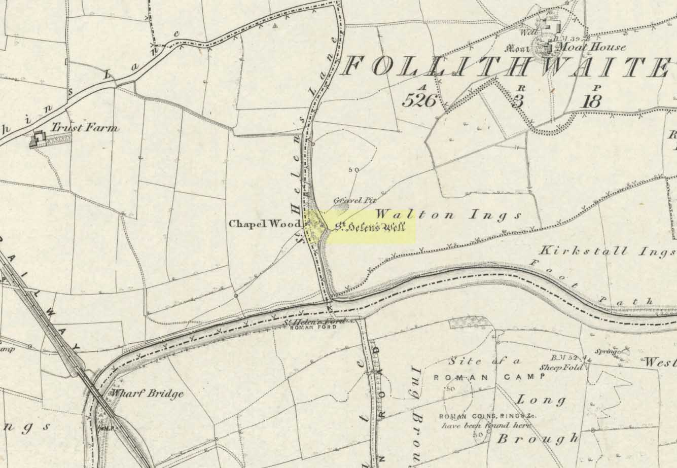
The well is all dried up today, but its remains are about 200 yards north of the river Wharfe. Sam Brewster (1980) told the easiest way to find it: “To get there from Thorp Arch you take the trackway that goes to the south of the church and follow this until you are walking alongside the river; eventually you will come to a barrier of barbed wire near some old disused water-works; get under or over this barrier and turn 90 degrees to your left, following the barbed wire until you come to a wood, the other side of the barbed wire; go into the wood and turn right; keep exploring near the edge of the wood until you find a tree under which is a hollow which used to be St. Helen’s Well.” Once here you can see where the water used to flow down a narrow channel and under a little bridge.
Archaeology & History
Carved cross remains found near St Helen’s Well
This ancient and well-known healing spring is shown on early OS-maps emerging a short distance north of the River Wharfe besides St. Helen’s Beck in Chapel Wood, adjacent to the Kirkstall Ing or field. In the western fields close by was once an ancient chapel and, closer to the holy well, once “stood St. Helen’s (or St. Helena’s) Cross, which is somewhat crudely represented in Dr. Whitaker’s History of Craven“, (Speight 1902), illustrated here.
This well possesses a prodigious occult history yet is curiously absent from most studies on the subject. The place is said to have been a respected holy site that was venerated long before the Romans arrived here. Found at a place called the Rudgate — but known locally as St. Helen’s Ford — it is also said to be haunted. Angela Smith (n.d.) considers the traditions surrounding the well to be pre-Roman, and the curative waters would certainly have been known of at the time of their occupation here,
“because it lies at the side of Roman road No.280, just north of where it crosses the River Wharfe at St. Helen’s Ford, leading to the Roman fort at Newton Kyme.”
St Helens Well in 1900
Several species of psychoactive plants grow adjacent to the well, which are thought by Phillips, (1976) Devereux (1992) and I as serving ritual shamanic purposes. The likelihood is more so than not. The oracular nature of the site which R.C. Hope (1893) and others have described here is particularly interesting: in traditions the world over, oracles were often consulted after the ingestion or use of sacred plants, such as are found here.
Due to the sacred nature of this spring and its importance in local folklore and history, it should be recovered from its present state. The fact that this place was highly important as a ritual and sacred site to christians, pagans, Romans and peasants alike, and now hides all-but-lost and forgotten is a disgrace.
Folklore
A fascinating tale hangs over this still-revered holy well which legend tells had a chapel standing adjacent, dedicated to Helen in the 7th century – although no trace of it is visible today. Local historian Edmund Bogg (1904) recounted how a local sexton told of “padfoots and barguests and ‘that grim foul beast with clanking chain’ which on dark nights kept its vigil” near St.Helen’s Well. Padfoots and barguests are Yorkshire names for spectral black dogs, said to be bringers of death and misfortune (they are one of several remaining folk-ingredients from the Underworld myths in British shamanism).
St Helen’s Well, c.1935St Helens Well in 1934
Folklorist Guy Ragland Phillips (1976), referring to an article in The Dalesman in 1971, told how a Mrs Dorothy Tate as a young girl used to visit the site and would tie pieces of rag on the bushes aside the place as grateful offerings to the spirit of the well. She said however, that she had gone about doing this in the wrong way, as according to tradition such offerings are to be done secretly. The article showed a photograph of Mrs Tate (from 1908) tying one of the memaws to the wych-elm tree overhanging the old spring.
People visited the well – probably on August 18 – to divine the future with the oracle which Hope (1893) described as being here, always in the dead of night without being seen, leaving before sunrise. It has been visited by thousands of people over the centuries, with gifts of rag-hangings, pins and other memaws. Such offerings continue even to this day. When Harry Speight (1902) visited St. Helen’s Well at the turn of the century, he related how as many as forty or fifty hangings would be left at any one time on the branches of the trees. He wrote:
“The water is beautifully soft and clear, and in former times was much resorted to as a specific for sore or weak eyes. There are two other springs close by, which were also held to be sacred, but they do not bear any particular dedications. An old plantation a little north of the well is known as Chapel Wood, which commemorates St. Helen’s chapel and the ancient church at Bilton, three miles further north, and about a mile to the east of the Roman Rudgate, is also dedicated to St. Helen.”
A few years before Speight’s visit here, Dr Fred Lees and the botanist, Robert Baines, visited St. Helen’s Well, and wrote similarly of the lore and memaws they found there:
“There are veritably hundreds of these bedizenings affixed and removed surreptitiously (probably before sunrise), according to an unwritten law, for none are ever caught in the act. And yet during the summer months a careful observer may detect almost weekly evidence of a shy communicant with the ghostly genius of someone¾country maid or her dumb shy swain. What murmured litany (if any) had to be said is lost; most likely nothing more was necessary than the unspoken wish…Pieced together and codified, fact and heresay testify as follows: ‘The visitor to the grove, before rise of sun, has to face the tree [a wych-elm overhanging the well] to detach from his or her own person some garment, to dip it in the well, and having knotted or whilst hanging the fragment to any convenient twig…is to breathe a ‘wish’ telling no-one what that wish may be; these conditions strictly observed, what is desired shall come to pass.'” (in Phillips, 1976)
When the archaeologist C.N. Bromehead (1935) and geologist J.V. Stephens came to the site in the 1930s, despite the fall of the well, he was surprised to find local peasants still respecting the spirits of the site, reporting:
“There is now no well or visible spring, but from the position at the lower margin of a gravel terrace it is obvious that water would be obtained by digging a few feet; a small stream flows just east of the site… It is curious that the hanging of rags should survive when the actual well has vanished, but the writer has visited the spot many times in the last seven years and there are always plenty of obviously recent additions. The custom is to stand facing the well (i.e., due west), preferably after sunset, wish, and then attach something torn from one’s clothing either to the big tree — wych elm — or to any of the bushes. Probably the custom is largely maintained by vagrants who frequently camp in the wood, but it also has its attraction for courting couples from the neighbouring villages!”
Such offerings at the site of St. Helen’s Well are still left by locals and some of the plastic pagans, who tie pieces of artificial material to the remnants of the wych-elm and other trees, which actually pollutes the Earth and kills the spirit here. Whilst the intent may be good, please, if you’re gonna leave offerings here, make sure that the rags you leave are totally biodegradable. The magical effectiveness of your intent is almost worthless if the material left is toxic to the environment and will certainly have a wholly negative effect on the spirit of the placehere. Please consider this to ensure the sacred nature of the site.
…to be continued…
References:
Bogg, Edmund, Lower Wharfeland, the Old City of York and the Ainsty, James Miles: Leeds 1904.
Brewster, Sam, ‘St. Helen’s Well,’ in Wind & Water 1:4, 1980.
Bromehead, C.N., ‘Rag Wells,’ in Antiquity IX, March 1935.
Cowling’s 1946 ground-plan of a portion of the settlement
From Blubberhouses church by the crossroads, walk up the slope (south) as if you’re going to Askwith, for 100 yards or so, taking the track and footpath past the Manor House and onto the moor. Once you hit the moorland proper, take the footpath that bears left going down into heather and keep going till you hit the dead straight Roman Road path running west onto Blubberhouses Moor. Go on here for nearly a mile until you hit the valley stream with its Eagle Stone down on your left. Walk downstream, past the Eagle Stone, and cross over 100 yards down until you’re back on the level ground with the scatter of bracken and heather. You’re here!
Archaeology & History
On the other side of the stream a short distance southeast of the large cup-marked Eagle Stone is a curious site, first described by Eric Cowling (1946) as “a series of enclosures of varying size and roughly circular shape” which he ascribed as a Bronze Age settlement. Certainly we have a rather extensive scattered group of walled structures just as he described, but not all of the walling here seems typical of local Bronze Age constructions. Cowling suggested the remains to be “useful for protection, herding and for shelter,” though admitted archaeological excavation would be the best way to ascertain their specific nature. Such undertakings have yet to be done — and I wouldn’t hold your breath either.
Large section of wallingWalls of large circular structure
Although he described some of the walls here as nearly four-feet tall, when Graeme Chappell and I first ventured here in the winter of 1990, the walling wasn’t quite as high. There are a number of individual tall stones sat in the walls that stand three-feet tall, with some that have been cut and dressed in more historic times. Who did this and when is unknown. However, if we visited this place when all the vegetation has been cut and burnt back at the end of winter and early months of Spring — a fact not lost on Cowling when he first found this place — we would gain a much clearer picture of things here.
Some sections of lower walling above the streamside appear to be prehistoric in nature, but many other parts of the walled structures across this flatland plain have a much later look and feel about them, illustrating that the site may have been used well into post-medieval periods. This seems increasingly obvious where we find a number of the stones cut at sharp angles, with some having distinctive quarried grooves in them. However, I can find no historical records to verify this at present.
Hut circle remainsMedieval cut upright stone?
If we walk up the slight slope westwards however (before bracken and heath grow) there are more distinct prehistoric remains in the form of typical hut circles with low walls emerging from deep peatlands — although even these have been cut in one or two places by metal tools. My view of this little-known but large settlement arena is that we’re looking at a site initially built in the Bronze Age period, continuing to be used by local tribespeople throughout the Iron Age and, as the cut stones clearly show, was a village that was certainly made use of in the last millenium. But until someone comes along here and gives the site the attention it deserves, we’re not gonna know…
On the southern fringe of the copious walled structures we also find a very curious medicinal chalybeate spring that may have been of some importance to those who once lived hereby. A ‘standing stone’ and prehistoric cairn can also be seen close by.
References:
Cowling, E.T., Rombald’s Way: A Prehistory of Mid-Wharfedale, William Walker: Otley 1946.
From Llangollen, take the A542 north for about three miles up along the famous Vale of Llangollen. At the ruined abbey of Valley Crucis continue along the same road for another ½-mile whence, at the side of the road in a field and upon a small mound, stands the ancient monument: the Pillar of Eliseg.
Archaeology & History
The sandstone pillar or pillar-shaft stands upon a large square-shaped base stone which sits atop a tumulus — a Bronze Age burial mound (cairn) inside which were found, during excavations in 1803, the remains of a body, perhaps that of a Romano-British or Dark-Ages chieftain (possibly Eliseg?), with what were described as “blue stones” both beneath and on top; the cremated body lying within a stone-slab chamber along with a silver coin. But the ancient pillar monument itself is much later in date — probably mid-9th century AD, though there has been speculation by some historians that the pillar was actually a tall cross, alas without its head, dating from a couple of centuries earlier, with the inscription being carved onto it sometime between 840-845 AD. It was erected by Prince Cyngen fab Cadell (Concenn) about the year 844 in memory of his great-grandfather Eliseg or Elise. Cyngen died in Rome in 854 AD.
Over the centuries the pillar has suffered from the ravages of time. Its long Latin inscription was originally 31 lines divided into readable paragraphs running horizontally but now only 7 or 8 of these lines are visible. But fortunately the writer and historian Edward Lhuyd made a drawing of the monument and its inscription back in 1696. The inscription when translated reads as follows:
1. Concenn son of Cadell, Cadell son of Brochmail, Brochmail son of Eliseg, Eliseg son of Guoillauc
2. Concenn therefore being great-grandfather of Eliseg erected this stone to his great-grandfather Eliseg
3. It is Eliseg who annexed the inheritance of Powys…throughout nine (years) from the power of the English which he made into a sword-land by fire
4. Whosoever shall read this hand-inscribed inscription stone, let him give a blessing on the soul of Eliseg
5. It is Concenn Who…with his hand…to his own kingdom of Powys…and which…the mountain…the monarchy Maximus…of Britain…Concenn, Pascent…Maun, Annan.
6. Britu, moreover, (was) the son of Guorthigirn (Vortigern) Whom (St) Germanus blessed and whom Severa bore to him, the daughter of Maximus the king who slew the king of the Romans and
7. Convarch painted this writing at the command of his king Concenn
8. The blessing of the Lord (be) upon Concenn and all members of his family and upon all the land of Powys Until the day of judgement or doom. Amen.
The upper section of the pillar, which is broken at the top, was re-erected on top of the burial mound in 1779 which probably means that the monument is not in its original place. The lower section was sadly broken away from the shaft during the English Civil war and has long since disappeared. However, this monument is still quite an impressive site and can be seen from a great distance around.
References:
Bartrum, P.C., Early Welsh Genealogical Tracts, Cardiff: UWP, 1966.
Barber, Chris, More Mysterious Wales, Paladin 1987.
Houlder, Christopher, Wales: An Archaeological Guide – the prehistoric, Roman and early medieval field monuments, Faber and Faber, London 1974.
Tyack, George S., The Cross in Ritual, Architecture and Art, William Andrews: London 1900.
Westwood, J.O., Lapidarium Walliæ – The Early Incised and Sculptured Stones of Wales, Oxford University Press 1879.
Maypole (destroyed): OS Grid Reference – SE 0458 9121
Redmire’s ancient Oak
Archaeology & History
As with many of Britain’s old maypoles, the one at Redmire has long since disappeared and no local in the 20th century appears to have had any memory of it. However, it was mentioned in Victorian times and described in McGregor’s (1989) fine history work on the village:
“At one time, somewhere on the Green, stood a maypole which was destroyed by lightning. I never heard the memory of it recalled during my early life, but it is mentioned in their books by both Barker and Bogg. The remnants of it appear to have been there in 1850 or 1852, as Barker, writing at that time says, ‘A maypole, rare in Yorkshire, stands on the Green. It was shivered to pieces by the electric fluid, during a thunderstorm, in the summer of 1849. This poor maypoles catastrophe would have been regarded by the old Puritans as a direct and visible manifestation of the wrath of heaven at such a heathenish practice.’ Redmire, as we know, took pleasure in dancing in the 19th century, and continued to do so, especially after the building of the Town Hall…”
When Edmund Bogg came here at the end of th 19th century, he saw “the base of the ancient maypole…near to, a twisted and ancient oak” whose ancient branches were being held upright by large wooden posts. This sacred oak itself was said to “still cast its shade over a small spring of water.” Unfortunately I ‘ve found no more about this lost pagan relic…
References:
Barker, W.G.M.J., The Three Days of Wensleydale, Charles Dolman: London 1854.
Bogg, Edmund, Wensleydale and the Lower Vale of Yore, E. Bogg: Leeds n.d. (c.1900)
McGregor, Isabelle, Redmire – A Patchwork of its History, privately printed: Redmire 1989.
The huge stone trough at the side of the Wycoller Beck further down than the old bridge had a pipe leading to it from a spring on the other side of the beck. Cookson & Hindle (1974) told that this was “the only source of drinking water” — which wasn’t quite true. In the old photo shown here, the groove in the supporting vertical stone once held a lid over the top of the trough, “to prevent animals, dead leaves, etc, from fouling it.” In addition to the old photo shown here, the well is also illustrated in Folley’s Romantic Wycoller (1949) with two young girls drinking the running water.
References:
Bentley, John, Portrait of Wycoller, Nelson Local History Society 1975.
Cookson, Stanley & Hindle, Herbert, Wycoller Country Park, H. Hindle: Colne 1974.
Folley, E.W., Romantic Wycoller, Coulton & Co.: Nelson 1949.


")
")

")
")


