From Steeton go to the top of Mill Lane, turning left up High Street. After about 200 yards, turn right (opposite Falcon Cliff street) and go down past the end of the row of terrace houses, to the end of the dirt-track past the allotments. Then cut up the fields to the rocky crags a coupla hundred yards above you on the left. Over the wall at the top, look out for the single tree in the field by the walling where there’s a small cluster of stones. That’s it!
Archaeology & History
The little Crater Stone and its more ornate companion, below
Hiding away on private land, this lovely simple carving was first located on Wednesday, April 7, 2010 (in the fine company of the Great Guru). Our initial assessment found it to be just a simple cup-marked stone with 4 normal cup-marks, plus two large ‘bowls’ just where the rock goes into the ground. When we found it the other day, Steve pulled a little bit of the earth back to get a better look at the stone, but we need to return here to unearth the rest of the stone (we didn’t have utensils with us this day, as we were just playing out).
The position of the stone in the land is excellent for views, looking down on the greater-looking Dragon Stone carving just a few yards away, but also looks across the Aire Valley and onto the moorland heights above Rivock, and the south-side of Ilkley Moor. I’ll update and add further notes and clearer images when we go back to the site (hopefully) in the next week (aswell as hopefully conjure up a more respectable title!).
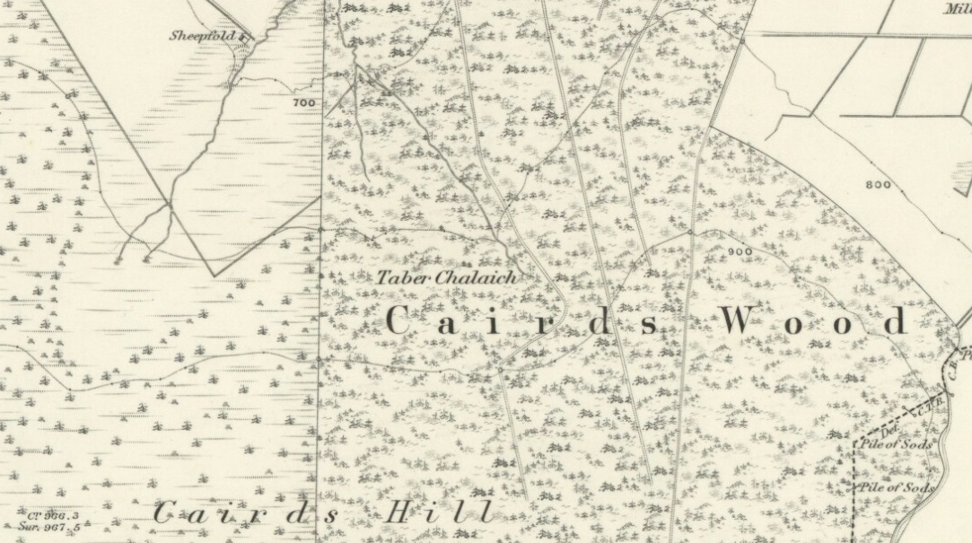
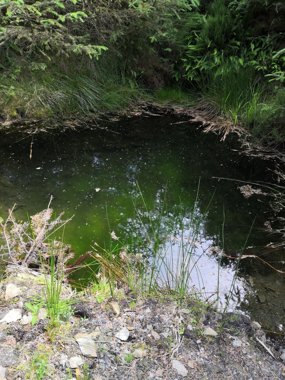
Described on the earliest OS-map of the region as Taber Chalaich, this great “well of the old woman, witch, or hag” is found on the northern slopes of Cairds Hill, amidst increasingly dense woodland up the top of the stream which ebbs and flows in strength (depending on the weather). A water source dedicated to the prima mater Herself — i.e., the heathen pre-Celtic female creation deity par excellence — it was once of considerable repute locally and was known to cure various ailments. It was described by Ruth and Frank Morris (1981) as being,
“the scene of a pagan ceremony in which the Earth Mother in her old woman phase bathed at the well and returned as a young maiden.”
Tobar na Cailleach (21st Century Pict)
This tells us that rites were enacted here around Imbolc (February 1-2). The well can still be found running. A visit to the site in July 2025 by Pol Anndrais found that “the East Side of the pool has been dug out and the rocks used to dam the outlet. The pool is roughly square, about 2 metres across. The inlet is over natural rock visible beneath the surface, the pool is about 1 metres deep and reasonably clear with pond skaters and diving bettles, (but) no visible offerings…”
On the hill at the top we find remains of old tombs (mistakenly ascribed by Mr & Mrs Morris as ‘stone circles’), some of which may have had some mythic relationship with this legendary water source. If anyone has any further information about the folklore or history of this site, we’d love to know about it.
From Skipton town centre follow the A6131 road south, out of town, for less than a mile, and turn left up Cawder Lane. Avoid following the road into the housing, instead bearing up the country lane to your left. Just before reaching the farmhouses 200 yards up, note the stony hilltop above you on your left (up behind Horse Close Farm). Walk up there for 250 yards NE and you’ll find it!
Archaeology & History
Horse Hill enclosure, looking W
This is an impressive site. I’d say very impressive! (but I’m easily pleased) Oddly however, I can’t find a damn thing about this place in any of my archaeo-records and it appears (as far as I’m aware) that no survey has ever been made of it. Which is bloody incredible! Indeed, the only archaeological notes that appear to exist about this very impressive and well-preserved Iron Age enclosure, states, “Subcircular enclosed settlement on Horse Close Hill 250m north of Horse Close Farm.” That’s it! Nothing else! So I’m afraid you’ve only got my crappy description of it to go on for the time being…
As the aerial image below shows, this is a large oval-shaped enclosure, defined primarily by an almost complete ring of double walling arranged around this hilltop site. Measuring approximately 78 yards (71m) north-south, and nearly 75 yards (70m) along its longer east-west axis, with a circumference of about 235 yards (215m), many of the upright stones which define its edges stand between 1-3 feet in height. Some of these stones have obviously been moved into position by the lads who built the structure, but the site has also taken advantage of a number of large earthfast boulders in its construction.
If you walk around the edges of the walled enclosure, almost every bit of it is clearly visible. Between the defining inner and outer walling of the structure we find sections of the site packed with smaller stones, giving the impression that it may once have been filled all round, making the walls thick strong defensive ones. But without a more detailed investigation, we’ll never really know…
Horse Close settlement, looking NEAerial view of enclosure
It is clearly very similar in structure, and probably date, to the well-known Brackenhall circle on Shipley Glen, near Baildon (though the nature of the Brackenhall site has long been a topic of controversy). And, as with the Brackenhall site, a number of cup-and-ring stones are found close by — including the Great Wood Laithe carving in the field immediately below on the west side. I’ve also found a similar structure to this on the hills above Steeton, a few miles to the south (though it’s not as well-defined as this one).
Although the site is mainly defined by its oval walling, we also find other stretches of walling that run outwards from the central site: one in particular running north-east for 35 yards out towards a small standing-stone further up the field. Other curious earthworks and remains scatter the fields on the eastern sides of this main feature, which the helpful farmer here pointed out to us.
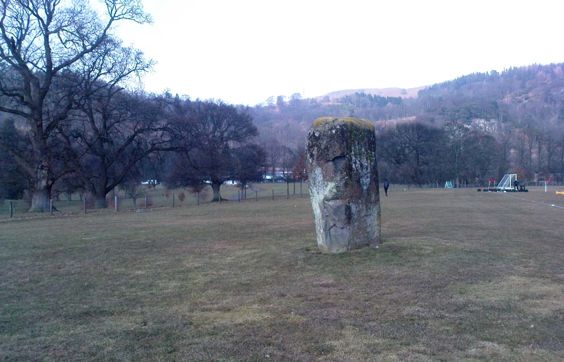
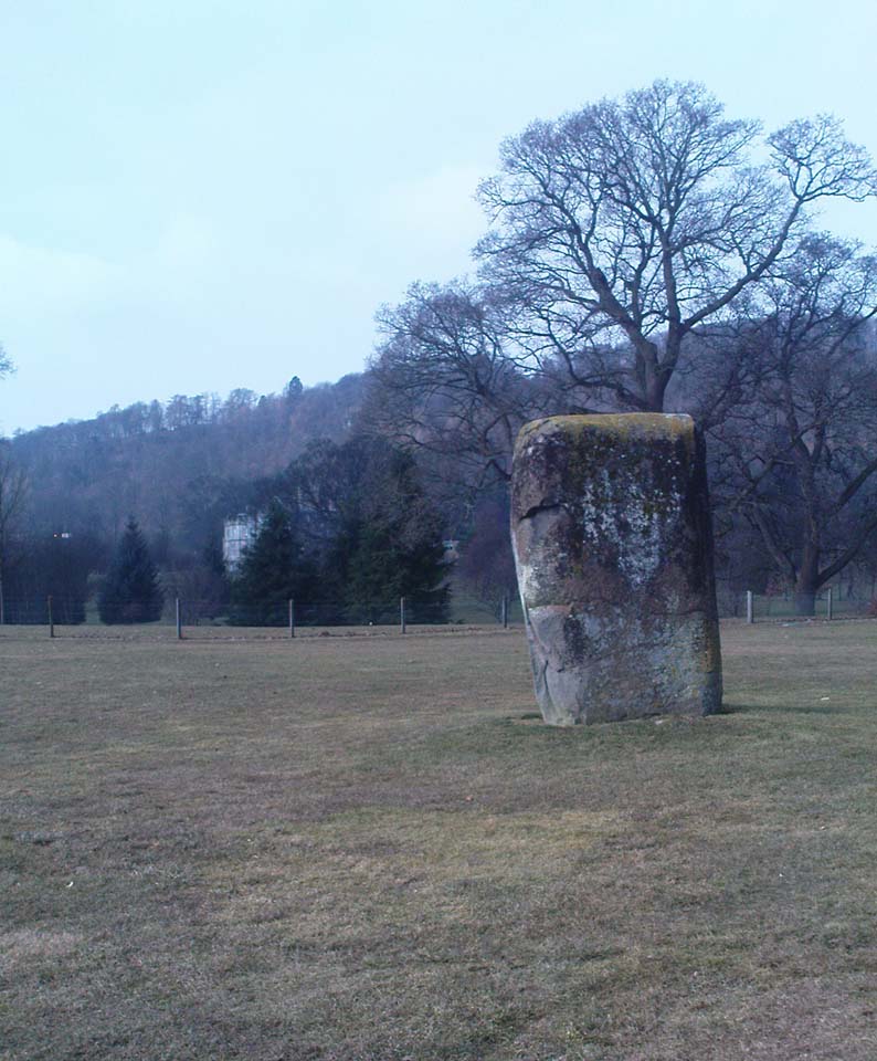
Dead easy to find! From Stirling head out on the A9 road towards Bridge of Allan and Stirling Uni. You’ll hit a small roundabout a mile out of Stirling – go straight across and up the little bendy road. Follow this round the bottom side of the Uni for a half-mile, watching out for the left-turn as the tree-line ends, taking you up to the factory behind the trees (if you hit the roundabout a bit further on, you’ve gone too far!). Go up the slope and onto the level sports playing fields – where this old beauty will catch your eye! If you somehow miss it, just get to the Uni and ask some of the students where it is!
Archaeology & History
Airthrey Stone, looking NW
This single standing stone is a beauty! It’s big – it’s hard – and it’s bound to get you going! (assuming you’re into megaliths that is) Standing proud and upright on the eastern fields of the Stirling University campus, A.F. Hutchinson (1893) measured it as being “9ft 1in in height. Its greatest breadth is 4ft 10in, and its circumference 14ft.” A bittova big lad! More than fifty years later when the Royal Commission (1963) lads got round to measuring its vital statistics, only an inch of the upright had been eaten by the ground. The stone was highlighted on the earliest OS-maps of the area.
Folklore
Of the potential folklore here, most pens and voices seem quiet; although Mr Hutchinson (1897) told of William Nimmo’s early thoughts, linking the history of this stone with the others nearby, saying:
“Of what events these stones are monuments can not with certainty be determined. In the ninth century, Kenneth II, assembled the Scottish army in the neighbourhood of Stirling, in order to avenge the death of Alpin his father, taken prisoner and murdered by the Picts. Before they had time to march from the place of rendezvous, they were attacked by the Picts… As the castle and town of Stirling were at that date in the hands of the Picts, the rendezvous of Kenneth’s army and the battle must have been on the north side of the river; and as every circumstance of that action leads us to conclude that it happened near the spot where these stones stand, we are strongly inclined to consider them as monuments of it. The conjecture, too, is further confirmed from a tract of ground in the neighbourhood which, from time immemorial, hath gone by the name of Cambuskenneth: that is, the field or creek of Kenneth.”
And although this hypothesis is somewhat improbable, it was reiterated in the new Statistical Account of 1845, which also suggested that this and the other Pathfoot Stone were “intended probably to commemorate some battle or event long since forgotten.”
References:
Hutchinson, A.F., “The Standing Stones of Stirling District,” in The Stirling Antiquary, volume 1, 1893.
Royal Commission on the Ancient & Historical Monuments Scotland, Stirling – volume 1, HMSO: Edinburgh 1963.
Pretty easy to find. Head down the B8051 road south, out of Stirling, for a ¼-mile. Keep your eyes peeled for the central police station on your right as you come out of town. The stones are on the grassy forecourt in front of the police station!
Archaeology & History
It’s amazing that these stones are still standing! Jut out of the city centre, very close to the main road and right outside the central police station: if these standing stones would have stood anywhere in England, they’d have been destroyed. Thankfully, the Scots have more about them regarding their history, traditions and antiquities.
Randolphfield stone SWNE Randolphfield stone
Of the two stones that remain here, they stand in (just about) the same position that they were shown as on an 1820 map of Stirling. The northernmost of the two is about 3½-feet tall and rests upright against the edge of the track and lawn; whilst its taller companion — knocking close on to six-feet tall — stands proudly near the middle of a well-kept lawn less than 50 yards away. Once you’ve found one, the other’s easy to spot!
It’s obvious that the larger of the two stones was cut down at some time in the recent past, as there are several blatant cuts where the standing stone had been snapped into at least three portions — but whoever did the damage was given a bittova bollocking, as the stone was cemented back into its near-original form and stood back upright again. To this day, as one of the female officers coming out of the station indignantly told me, “they’re protected!” Long may they stay that way!
In Mr A.F. Hutchinson’s (1893) early description of these stones he told that they stood “in a line from SW to NE — the line of direction making an angle of 235° with the magnetic north.
“The southwest stone stands 4ft above the ground. The portion underground measures 2ft 5in; so that in all it measures 6ft 5in. Its girth is 6ft 6in. It is four-sided in shape—nearly square—three of the faces measuring each 21 inches, and the fourth 15 inches. The northeast stone is smaller and less regular in form. Its height above ground is 3ft 6in, and its girth 4ft 6in. Both stones are pillars of dolerite, of the same material as the pillar stones of the Castle rock, from which place they have apparently been brought. The larger stones shows some marks on it, which have been supposed to be artificial. They are , however, merely the natural joints characteristic of these blocks…”
Folklore
Like many standing stones scattering our isles, this site possesses the old tradition of them marking a battle — in this case, the Battle of Bannockburn. Once again, Mr Hutchinson (1893) wrote:
“The local tradition as to the origin and meaning of these stones is well-known. It is thus stated by (William) Nimmo in his History of Stirlingshire, p.84…: ‘Two stones stand to this day in the field near Stirling, where Randolph, Earl of Murray, and Lord Clifford, the english general, had a sharp encounter, the evening before the great battle of Bannockburn.’ Again, p.193:- ‘To perpetuate the memory of this victory…two stones were reared up in that field and are still to be seen there.’ …The Old Statistical Account of St. Ninians (Rev. Mr Sheriff, 1796), makes the same statement, p.406-8:- ‘In a garden at Newhouse, two large stones still standing were erected in memory of the battle fought on the evening before the battle of Bannockburn, between Randolph and Clifford.'”
Yet the name ‘Randolphfield’ is apparently no older (in literary records) than the end of the 17th century and the thoughts of Hutchinson and other local historians is that the two stones here, whilst perhaps having some relevance to an encounter between the Scots and the invading english, were probably erected in more ancient times.
References:
Hutchinson, A.F., “The Standing Stones of Stirling District,” in The Stirling Antiquary, volume 1, 1893.
Royal Commission on the Ancient & Historical Monuments Scotland, Stirling – volume 1, HMSO: Edinburgh 1963.
Go up Jura’s only road until it becomes a dirt-track and head along the track to the east to the natural hillock on the coast. You’ll pass the three standing stones of Knockrome before you get to this one, right by the end house.
Archaeology & History
Found in a beautiful setting, this is a thick little stone but is less than four feet tall and it may have had some shapely relationship with one of the hills (Corra Bheinn) on Jura. The Royal Commission (1984) described it merely as, “an erratic boulder measuring 3.1m in girth at the base, and 1.2m in height with its longer axis aligned roughly east and west.” Several other stones can be found nearby.
References:
Royal Commission on the Ancient & Historical Monuments of Scotland, Argyll – volume 5: Islay, Jura, Colonsay and Oronsay, HMSO: Edinburgh 1984.
Cup-and-Ring Stone (destroyed): OS Grid Reference – NT 138 746
Archaeology & History
Lost carving of Carlowrie
Two-thirds of a mile west of the Cat Stane, on land immediately north of the River Almond by Edinburgh Airport in an area that was reported in 1780 to be “filled with the skeletons of human bodies,” this old petroglyph could once be found. The Scottish Royal Commission (1929) described it as being a covering stone for a short prehistoric tomb near the OS-grid reference cited here, “but when discovered it was much broken by the plough that it does not appear to have been preserved.” They refer instead to the last report of the site in the Scottish Society of Antiquaries journal, where we were informed that the cover stone was,
“marked with three series at least of concentric circles… The widest diameters of the sets of rings cut on the inside of the lid is about five inches, and each set is composed of five concentric circles.”
All trace of this carving appears to have been lost. Other carvings reported nearby in the 19th century also appear to have been lost or destroyed.
References:
Morris, Ronald W.B., The Prehistoric Rock Art of Southern Scotland, BAR 86: Oxford 1981.
Royal Commission on Ancient & Historical Monuments, Scotland, Midlothian and Westlothian, HMSO: Edinburgh 1929.
Simpson, J.Y., The Cat-Stane, Edinburghshire, Neill & Co: Edinburgh 1862.
Simpson, J.Y., “On Ancient Sculpturings of Cups and Concentric Rings,” in Proceedings of the Society of Antiquaries, Scotland, volume 6, 1864-66.
Not too troublesome to locate really… It’s at the top-end of the University, just above the side of the small Hermitage Road, about 100 yards along. Keep your eyes peeled to your left!
Archaeology & History
Pathfoot Stone
Today standing proud and upright, this ruinous standing stone has been knocked about in the last couple of hundred years. Although we can clearly see that it’s been “fixed” in its present condition, standing more than 10 feet high, when the Royal Commission lads came here in August 1952 (as they reported in their utterly spiffing Stirlingshire (1963) inventory), it wasn’t quite as healthy back. They reported:
“Many years ago the stone, which is of dark grey dolerite, fell down and was broken, and the basal portion, now re-erected, is only 3ft 10in high; two large fragments however, still lie beside the base, and the original stone is said to have stood to a height of 9ft 4in. Of a more or less oblong section throughout, the re-erected stones measures 2ft 10in by 1ft 10in at ground level, swells to its greatest dimensions (3ft 2 in by 1ft 9in) at a height of 1ft 4in, and diminishes at the top…”
…and again!
But the scenario got even worse, cos after the Royal Commission boys had measured it up and did their report, it was completely removed! Thankfully, following pressure from themselves and the help of the usual locals, the stone was stood back upright in the position we can see it today. And — fingers crossed — long may it stay here!
Folklore
Commemorative plaque!
A plaque that accompanies the monolith tells that the old village of Pathfoot itself was actually “built around this standing stone” — which sounds more like it was the ‘centre’ or focus of the old place. An omphalos perhaps? The additional piece of lore described in Menzies (1905) work, that an annual cattle fair was held here, indicates it as an ancient site of trade, as well as a possible gathering stone: folklore that we find is attributed to another standing stone nearby.
Hutchinson, A.F., “The Standing Stones of Stirling District,” in The Stirling Antiquary, volume 1, 1893.
Hutchinson, A.F., “The Standing Stones and other Rude Monuments of Stirling District,” in Transactions of the Stirling Natural History and Antiquarian Society, 1893.
Royal Commission on the Ancient and Historical Monuments of Scotland, Stirlingshire – volume 1, HMSO: Edinburgh 1963.
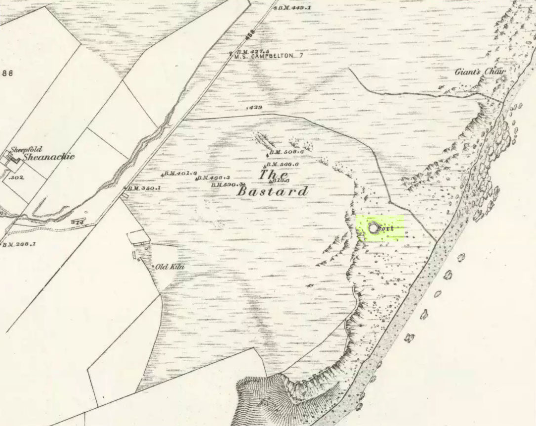
Pretty easy. From Campbeltown, follow the coastal round south for about 8 miles, past the TV masts on the skyline and the hamlet of Feochaig, where you’ll see the large rounded hill on your left near the coast: that’s The Bastard! Go onto the hill’s eastern sides and drop down the steep slope towards the large bend in the burn where its remains are on a ridge close to the cliffs overlooking the sea. The ruins are pretty faint but if you scout around, you’ll find it.
Archaeology & History
I couldn’t believe it when I found this one – so had to get the notes to the site and add what I could find! When the fellas from the Scottish Royal Commission checked the place in 1960, they described,
“On a narrow shelf halfway down the east flank of the hill named The Bastard there are the remains of a dun… Oval in plan, the dun measures about 15m by 12m internally and is entered from the east, where a stretch of the outer face is visible. Here the wall is 4m thick on either side of a straight passageway, 0.9m wide, which exhibits no trace of door-checks.”
The Bastard (RCAHMS 1971)
There are other remains a few yards to the southeast of the main structure which are thought to be “remains of an outer wall…about 1.2m in thickness, which has been drawn across the shelf to provide additional protection for the entrance”, more probably from the weather conditions than invasive incoming humans.
To the immediate north we have a mythic-sounding Giant’s Seat (just above the natural arch) and west is the abode of the fairy folk – but I aint checked out the tales behind them yet.
References:
Royal Commission Ancient & Historic Monuments, Scotland, Argyll – Volume 1: Kintyre, HMSO 1971.
An unexcavated ring cairn in a very good state of preservation can be seen in the field immediately west of the River Halladale. Measuring more than 14 yards across east-west and 15 yards north-south, the site stands in association with several other unexcavated cairns.
Folklore
Although some of the cairns here have been found with prehistoric burials in them, tradition tells that the cairns here were the result of “a great battle between the native Pictish inhabitants and the invading Norsemen.” So wrote George Sutherland, many moons ago. He continued:
“The Norsemen were defeated in that battle, and Halladha, their leader, was slain. It is from him that the river and the dale take their name. The battle was fought on a hillside, on the east side of the river and that hillside is covered with cairns which are supposed to mark the graves of those slain in this battle, but the body of Halladha, the norse leader, was interred on the west side of the river, and his sword was laid in the grave beside his body. Near the circular trench where he is said to have been buried there are several heaps of stones which are supposed to mark the graves of other Norsemen of note who fell in the battle.”
References:
Sutherland, G., Folklore Gleanings and Character Sketches from the Far North, John o’ Groats Journal: Wick 1937.