Holy Well, Hollinshead Hall, Tockholes, Lancashire

Holy Well:  OS Grid Reference –  SD 6636 1994

Getting Here

Take the A675 road to Bolton from Abbey Village, going up the track opposite Piccadily farmhouse until you reach the ruins in the woods.  The site can also be reached by going south down the Tockholes Road car park following the sign for Hollinshead Hall on your right.

Archaeology & History

Hollinshead Hall
Hollinshead Hall

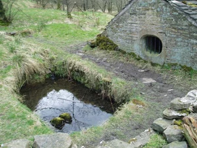
Associated with Hollinshead Hall, which is now a ruin, the well is made of the same sandstone rubble as the hall with a stone slate roof. The building a single cell is built into a slope from which the spring arises and is encapsulated by it. Either side a high walls creating a sort of forecourt with side benches with inward-facing chamfered piers with ball finials at the ends. The well house itself is quite an attractive building and is certainly not thrown up, having a symmetrical facade with chamfered unglazed widows which are fitted with spear-headed iron bars and clearly the building has never been glazed. The gable end has a large oval opening with a matching one at the rear. In the centre is a heavy board door with a chamfered doorway. This doorway unfortunately is locked baring any entrance to the well house.

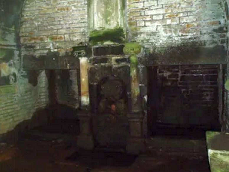
Peering in through the windows one can see how strong the vaulted roof is, adorned by a pendent ball in its centre. The spring’s water flows from a crudely carved lion’s head, either side of a reredo of Ionic colonnettes, with a sunken stone tank beneath or each side a rectangular recess which enclose rectangular pools. There is a diamond-paved floor with a central gutter draining from this well or trough at centre of rear wall.

Local tradition accounts that there was a site here from Medieval times and indeed, that the name Hollinshead was derived from a version of holy well although O.E hol, for hollow is more likely although there is a Halliwell Fold Farm nearby being derived from O.E halig for healing. The pool with steps down above the well house may be the original well of course. The discovery of a hoard of medieval coins in 1970s would support the date and perhaps they were an offering.

Folklore

Abram’s Blackburn (1877) is perhaps the first to state that the water was curative. However, anonymous quote in Nightingales History of Tockholes  describes the well as:

“Here no less than five different springs of water, after uniting together and passing through a very old carved stone representing a lion’s head, flow into a well.  To this Well pilgrimages were formerly made and the water which is of a peculiar quality, is remarkable as an efficacious remedy for ophthalmic complaints.”

 Another tradition is that the site was a resting place for pilgrims to Whalley Abbey and that the trough was used as  baptistery, however, this would be more likely to be the spring above the well house.  It is probably a spring house, a structure built over a natural source of water for the storage of dairy products and other foods that needed to be kept fresh.

Reculsancy, was very prevalent in Lancashire and the well house does the bear the coat of arms of the Radcliffes . It would suggest why the structure is so ornate and suggest a 1600s date although many authorities suggest an 18th century origin.  The site would be a secret baptistery and its design as a dairy, would also help as well as being still function, certainly the presence of benches suggest this functionality. It appears to be too close to the house to be a garden folly such as a grotto! The suggestion of stained glass in the windows suggests something more significant discovered during the present stone roof’s construction. Indeed, the choice of the lion’s head is possibly that of the ‘Lion of Judah’, meaning Jesus providing rich and valuable water, although this is a common motif on many drinking fountains of course! Interesting, Cramshaw (1994) tells us that the site was in the 1980s the site of a well dressing, although what type is unclear and no other author has mentioned it as far as I am aware. Perhaps we shall never know the real origin of this delightful building.

References:

  1. Abram, William Alexander, History of Blackburn, Toulmin: Blackburn 1877.
  2. Billington, W.D., From Affetside to Yarrow, Ross Anderson: Bolton 1982.
  3. Crawshaw, J., “Hollinshead Hall Holy Well”, in Source new series Issue 2, Winter 1994.

Edited from – Holy & Healing Wells

© R.B. Parish, The Northern Antiquarian


Ashleigh Barrow, Darwen, Lancashire

Tumulus (destroyed):  OS Grid Reference – SD 696 208

Also Known as:

  1. Whitehall Tumulus
Ashleigh Barrow urns (after John Dixon)

Archaeology & History

Early accounts of this site tell of its destruction in the 19th century, but a modern reconstruction of the site has been made close to where it once stood.  And this tomb sounded quite impressive!  Within the ‘tomb’ were found a large number of urns, one of which was curiously empty.  In John Dixon’s excellent Journeys through Brigantia (2003) work he told that,

“Contemporary reports about its excavation state that it was of circular form about 30 yards in diameter, being formed on a naze or promontory of an undulating plateau overlooking the Darwen valley.  Its height was said to vary between 10 to 12 feet on the east side and between 2 or 3 feet on the west, the centre being about 6 feet in diameter and consisting of a slight hollow.

“Ten interments appear to have been made, one being just a heap of burnt bones, the others, having been enclosed in urns, the majority of which are badly broken, consisted of ashes and fragments of bone together with unrecognizable pieces of bronze.  Two urns also contained ‘incense cups’ and another a 7½-inch bronze knife or dagger.

“The design of the urns is similar to those from the Middle Bronze Age… All but two of the urns were found within an area 21 feet by 14 feet, whilst one was 40 feet away.  They were, with one exception, placed in the Earth with the orifice pointing upwards and were covered with slabs, the depth at which they were found varying from 1 to 2 feet.”

Remains of the urns can be seen on display in the Darwen Library.

Folklore

Once again in John Dixon’s (2003) fine Journey’s through Brigantia volume, we read of folklore relating to the respect of the dead which local people used to give this old tomb, telling:

“Many superstitions were attached to the barrow and its destruction in the 1860s, with the country people speaking of the place being haunted by ‘boggarts’ and children having been known to take off their clogs or shoes and walk past it barefoot in the night time.”

References:

  1. Dixon, John, Journeys through Brigantia – volume 11: East Lancashire Pennines, Aussteiger Publications: Barnoldswick 2003.

© John Dixon & Paul Bennett, The Northern Antiquarian 


Pleasington Cemetery, Blackburn, Lancashire

Tumulus:  OS Grid Reference – SD 650 272

Getting Here

The site is situated in a natural hollow just above a steep sided ravine known as Scotsman’s Wood through which a stream flows. The location in the hollow obscures all surrounding views of the East Lancashire Pennines and the Billinge Hill massif. The near surrounding area is on a natural sandbank created by the western shore of the post-glacial ‘Lake Accrington’.

Archaeology & History

During the early spring of 1996, grave digger Grant Higson, whilst excavating a new grave, uncovered course fragments of pottery displaying a herringbone pattern and other material. Grant stopped work immediately and alerted Blackburn Museum worker Maggy Simms, who gathered together the shattered remains and brought in Lancaster University Archaeological Unit for identification. They identified the fragments to be a Bronze Age Urn some 12 inches in height, decorated with a herringbone pattern and containing bones and ashes of several cremations, some stained green by some copper object that had disintegrated over the years. The burial was assigned to c. 1500 BC, a period of history referred to as the Bronze Age. The urn and its contents are now held by Blackburn Museum. A geo-physical survey was undertaken by the Unit on the surrounding areas that displayed undulation of the ground surface but nothing was found, the undulations deemed natural features.  No archaeological report or radiocarbon dating has been made to date by Blackburn Museum Service, the Lancaster University Archaeological Unit being now defunct.

During August 2009, I visited the site and was fortunate to meet with Grant Higson who not only showed me the location of the find, but also described the geological formation of the cemetery area.

The urn found is typical of the well developed Pennine urns recovered from the Anglezarke, Bleasdale and Burnley districts and a date of 1500+250 BC is more than likely cet. par.

Given the ‘sheltered’ location of the find I would ascribe the site as one of a primary domestic nature, the burial being a secondary feature: primary tumulus burials in prominent locations being the sole preserve of the ruling aristocracy. What we are looking at is a hearth burial within a communal living hut: following the Indo-European custom, the dead were given to the Earth inside the human habitation. The dear departed, who had been so close to the family group in life, had to remain among them in death also and share the family’s joys and struggles, food and drink. While living they had enjoyed nightly rest under the roof of the communal hut, dead they slept the eternal slumber beneath the domestic heart.

This site is noted by ’TheElf’ on The Modern Antiquarian. ‘TheElf’ goes on to mention, “I saw what could possibly be a standing stone, some 200 metres north east of the cemetery.”   I located this stone (SD 648 273) and found it to be a broken 17th century gate-stoop for pole fence – a gate post with a series of holes used to create a ‘heck’, being an adjustable series of pole bars in lieu of a gate.

Article contribution courtesy of John Dixon – © John Dixon 2009.