Wycoller Bridge, Trawden, Lancashire

Cup-Marked Stones:  OS Grid Reference – SD 931 393

Getting Here

Easy enough to find once you’ve actually got to Wycoller.  By car, the only real way to get here is from Colne, through the village of Winewall, and along the Wycoller road, which runs to a dead end.  Once here, the old packhorse bridge with these cup-marks on it can’t be missed!

Archaeology & History
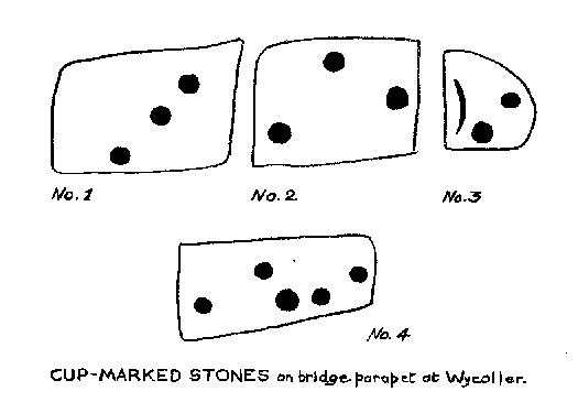
Wycoller Bridge's cup-marked stones (after Jackson, 1962)
Wycoller Bridge’s cup-marked stones (after Jackson, 1962)

A weird one this!  On the famous packhorse bridge close to the old hall, four of the stones have cup-markings etched onto them.  It seems that at least three of the carvings are archaic; with cups on one of the stones being somewhat deep and may actually be medieval.  But we simply don’t know….  A short article describing them was in the Bradford Cartwright Hall Archaeology Bulletin (1962) where they were equally as puzzled about them.  In 1979, J.A. Heginbottom described them in his survey on the prehistoric rock-art of upper Calderdale.  It’s possible that the stones on which the cups were carved might have been taken from a prehistoric tomb on the edge of the moor further up the valley from here.

Folklore

Just next to this bridge is another, much older one, known locally as the Clapper or Druid’s Bridge which perhaps has some bearing on the curious cup-markings.  Legend tells that this older construction was so called “because legend has it that it led to an amphitheatre where the druids held human sacrifices” – and the field just up from here (to the southwest) was known as the Dripping Stone Field.  Hmmmmm…..

References:

  1. Bentley, John, Portrait of Wycoller, Nelson Local History Society 1975.
  2. Heginbottom, J.A., The Prehistoric Rock Art of Upper Calderdale, unpublished report: 1979.
  3. Jackson, Sidney, ‘Cup-Marked Stones at Wycoller,’ in Cartwright Hall Archaeology Group Bulletin, October 1962.

© Paul Bennett, The Northern Antiquarian

The Great Stone, Downham, Lancashire

Legendary Rock:  OS Grid Reference – SD 78212 44402

Also Known as:

  1. Downham Cross (Byrne 1974)

Getting Here

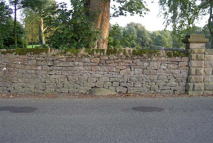
The best way to locate this is probably by starting from the pub opposite the old church of St. Leonard and heading west along the village road, past three large gate-entrances, until reaching the conspicuous milestone by the road junction.  On the other side of the road, just before the gate entrance to Downham Hall, edged into the base of the wall, we find this ‘ere The Great Stone.

Archaeology & History

The Great Stone, Downham

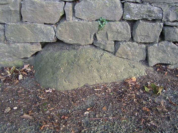
What a truly beautiful little village we find in Downham, nestled quietly and with age at the northern edge of Pendle hill.  It’s tucked away, off any main road so maintaining its sense of age and almost reclusive nature.  There is hidden history a-plenty scattering the landscape here, but tales of our Great Stone — thought by some as an old monolith; remains of a Roman milestone by others; whilst some just denote it as nowt but a small stone — is what brought me here.  It’s name betrayed my expectation (I always hope for too much it seems…), but the small pock-marked stone has been embedded in its present position for at least 150 years, as the growth of soil and tree behind it shows.  Archaeo-historians say little of it (reputations y’ know!) until something substantial is found; but thankfully we came upon the lovely couple who are Lord and Lady Clitheroe of Downham Hall, who told us more…

Folklore

“There are a couple of humourous legends told of the Great Stone,” Lord Downham began… But to a (sometimes) courteous megalithomaniac like myself, the tales rang the all-too-familiar bell.

Close-up of the Great Stone

The original position of the stone, though not known for certain, was some short distance away either across the road, or further along in a nearby field.  When it was moved – Lord Downham said around 1830 – the remains of a body were found beneath it; but another source told in fact that it marked “the final resting place of two legionaries who died on the nearby Roman road during trouble with the Brigantes.” (An old Roman road is nearby)  But apparently this old stone also moves. When the church bell strikes midnight the stone is said to turn itself around upside-down. Where have we heard that before!?

The site is described in Clifford Byrne’s (1974) unpublished manuscript on the crosses of Lancashire, where he cites it as being the remains of a cross pedestal, but adds that “if ever a cross stood by the village green, no memory of seems now to exist.”  But Mr Byrne also described the all-too-familiar heathen folk tales, saying:

“A local man told the writer that the object is called Downham Stone and that it turns over every night at midnight.  We read elsewhere that the boulder is called “the great stone of Downham” and that it turns at the stroke of midnight by the church clock.”

References:

  1. Byrne, Clifford H., “A Survey of the Ancient Wayside Crosses in North East Lancashire,” unpublished manuscript, 1974.
  2. Lofthouse, Jessica, Three Rivers, Robert Hale: London 1946.
  3. Lofthouse, North Country Folklore, Robert Hale: London 1976.
  4. Winterbottom, Vera, The Devil in Lancashire, Cloister: Stockport 1963.

© Paul Bennett, The Northern Antiquarian

Sowerby Lad, Mytholmroyd, West Yorkshire

Standing Stone (destroyed): OS Grid Reference – SE 024 244

Archaeology & History

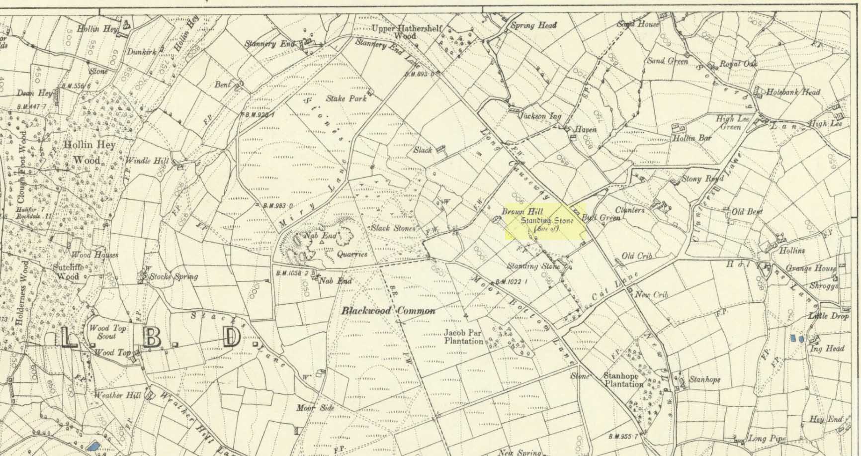
Standing stone on 1894 map

Also known as the Field House Standing Stone, this monolith seems to have gone.  It was first described in local Minister’s Accounts of 1403, and then again in the Wakefield court-rolls of 1515.  By the time John Watson (1775) wrote about the place there had been several other references describing this old “standyngstone”. It was still upright in 1852, but Ordnance Survey showed it as “Site of – ” at the beginning of the 20th century, and the stone had been moved a short distance away, further down from its original position to a spot at the side of the old trackway — but all trace of it has since vanished.

Folklore

This is thought to have been the standing stone which Robin Hood threw here, from the appropriately called Robin Hood’s Penny Stone at Wainstalls. The tale tells how he dug it out of the ground with a spade and threw it three-and-half miles across the valley until it landed here. Ooh, what a strong boy!

References:

  1. Bennett, Paul, The Old Stones of Elmet, Capall Bann: Milverton 2001.
  2. Smith, A.H., The Place-Names of the West Riding of Yorkshire, volume 3, Cambridge University Press 1961.
  3. Watson, John, The History and Antiquities of the Parish of Halifax, T. Lowndes: London 1775.

© Paul Bennett, The Northern Antiquarian

Skirtful of Stones, Horton-in-Ribblesdale, North Yorkshire

Cairn (destroyed):  OS Grid Reference – SD 785 747

Getting Here

Although apparently long gone, we could find this giant prehistoric tomb on the eastern side of the great Ingleborough and was one of many with this name once scattering the mid-Pennines. It was found less than a mile south of the hamlet of Selside, a few miles above Horton-in-Ribblesdale, on the west side of the B6479 and its existence is thankfully preserved in the place-name, ‘Borrens’, where the giant tomb was once found, 200 yards south of Gill Garth Farm.  If you look on the OS-map, you’ll notice an ancient settlement site close by.

Archaeology & History

In 1892, the great Yorkshire historian Harry Speight told us:

“We have no proper account of it, but it was doubtless ransacked and removed in the expectation of finding treasure. It is mentioned…in the Gentleman’s Magazine for 1761, as follows:

‘In the valley above Horton, near the base of this mountain (Ingleborough), I observed a large heap or pile of greet-stones all thrown promiscuously together, without any appearance of building or workmanship, which yet cannot be reasonably thought to be the work of Nature. Few stones are found near it, though ’tis computed to contain 400 of that country cart-loads of stones, or upwards. There is likewise another at the base north-east, in resemblance much the same, but scarce so large.'”

Speight speculated that it may have been raised to commemorate “some dire conflict between the Romans and the native hill tribes, as it lay on the old Roman thoroughfare across Ribblehead to the camp under Smearside.” We may never know this for sure, but there are plenty of Iron- and Bronze Age remains scattering this region – and just a few hundred yards south of this lost cairn are the old remnants of an ancient settlement…whose pages and images (it is hoped) will appear on TNA in the near future…

References:

  1. Smith, A.H., English Place-Name Elements, volume 1, Cambridge University Press 1956.
  2. Smith, A.H., Place-Names of the West Riding, volume 6, Cambridge University Press 1961.
  3. Speight, Harry, The Craven and Northwest Yorkshire Highlands, Elliott Stock: London 1892.

© Paul BennettThe Northern Antiquarian 


Simon’s Seat, Skyreholme, North Yorkshire

Sacred Hill:  OS Grid Reference – SE 0788 5981

Getting Here

Simon’s Seat in the centre & the Lord’s Seat immediately east

Tons of ways here.   To those who drive, take the Grassington-Pateley Bridge (B6265) road and a couple of miles past the village of Hebden, you’ll see the high rocks climbing on your southern horizon, with another group of rocks a few hundred yards along the same ridge.  That’s it!

Archaeology & History

This is an awesome site, full of raw power. It commands a brilliant view all round, but it is the north which truly draws the eye’s attention. Beneath the great drop of this huge outcrop is the haunted and legendary Troller’s Ghyll. The scent of as yet undisclosed neolithic and Bronze Age sites purrs from the moors all round you and there can be little doubt that this was a place of important magick in ancient days.

What seems to be several cup-markings on one of the topmost rocks are, to me, authentic. Harry Speight mentioned them in his 1892 work on the Craven and Northwest Yorkshire Highlands – but there are a number of other rocks in this giant outcrop with “possibles” on them.

Folklore

The name of this great rock outcrop has long been a puzzle to historians and place-name experts.  One tale that was told of Simon’s Seat to the travelling pen of one Frederic Montagu in 1838, told that,

“It was upon the top of this mountain that an infant was found by a shepherd, who took it to his home, and after feeding and clothing it, he had the child named Simon; being himself but a poor man, he was unable to maintain the foundling, when it was ultimately agreed to by the shepherds, that the child should be kept “amang ’em.”  The child was called Simon Amangham and the descendants of this child are now living in Wharfedale.”

The usually sober pen of Mr Speight thinks this to have been one the high places of druidic worship, named after the legendary Simon Druid. “It is however, hardly likely,” he wrote, “that he ever sat there himself, but was probably represented by some druidical soothsayer on whom his mystic gifts descended.”

I’ve gotta say, I think there’s something distinctly true about those lines. Visit this place a few times, alone, during the week, or at night – when there’s no tourists about – and tell me it isn’t…

References:

  1. Bogg, Edmund, Higher Wharfeland, James Miles: Leeds 1904.
  2. Montagu, Frederic, Gleanings in Craven, Simpkin Marshall: London 1838.
  3. Speight, Harry, The Craven and Northwest Yorkshire Highlands, Elliott Stock: London 1892.

© Paul Bennett, The Northern Antiquarian

Scale House, Rylstone, North Yorkshire

Tumulus:  OS Grid Reference – SD 97088 56870

Getting Here

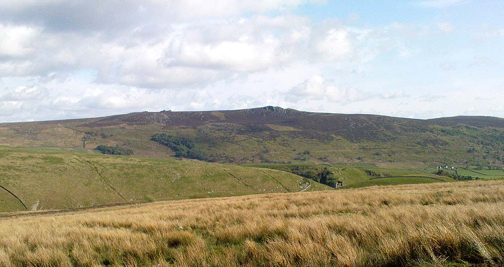
Pretty simple really.  Go up the B6265 Skipton-Rylstone road for about 3 miles, past the Nettlehole Ridge woodland on your right.  The next turn along to your right, up the track, is Scale House.  Go past this until you get to Scale House Farm.  The remains of the burial mound is in the field to your left, just before the farm.  Knock on the door and ask!

Archaeology & History

This ‘tumulus’ (as it’s marked on the OS-map) was one of the many explored by the legendary reverend William Greenwell (1864) in the middle to latter-half of the 19th century.  His description of the finds at Scale House were considerable; thankfully our old Yorkshire antiquarian Edmund Bogg (1904) shortened it and told us the following:

“The tumulus was 31 feet in diameter and about 7 feet high; it opened from the southeast; the soil immediately under the sod consisting of yellow clay to a considerable depth; then layers of blue clay… Exactly in the centre…at a depth of 7 feet, and on a level with the plane of the field, was found an oak coffin, formed out of a tree, split and hollowed-out, and placed due north and south, the head being placed to the south, as that as the larger part of the tree. After being exposed to the air for about 2 minutes, the bared coffin parted at the sides, and could not be moved except by detached pieces. The body had been wrapped in a cloth or shroud of texture resembling wool and coarsely-woven, of which there was a considerable quantity remaining; but the body itself was dissolved… The interment was considered to be that of an ancient Briton… The learned antiquary said it was the only instance (except the one at Gristhorpe, near Scarborough) where an interment in an oak tree hollowed out had a tumulus placed over it. It was more than 6 feet in length inside and about 7 feet 6 inches outside. The remains were carefully replaced and the mound restored to its former shape; a small leaden tablet being placed within, stating that it had been opened in AD 1864.”

Folklore

Jessica Lofthouse (1976) listed this as one of the places reputed to be an old fairy haunt, wherein “the folk of Scale House discovered a fairy kist or chest.”

References:

  1. Bogg, Edmund, Higher Wharfeland, James Miles: Leeds 1904.
  2. Greenwell, William, British Barrows, Clarendon Press: Oxford 1877.
  3. Lofthouse, Jessica, North Country Folklore, Hale: London 1976.

Links:

  1. Out of Oblivion: Archaeology and Notes – Directions and notices on this once giant tomb.

© Paul Bennett, The Northern Antiquarian

Robin Hood’s Penny Stone, Wainstalls, West Yorkshire

Stone Circle (destroyed):  OS Grid Reference – SE 046 288

Archaeology & History

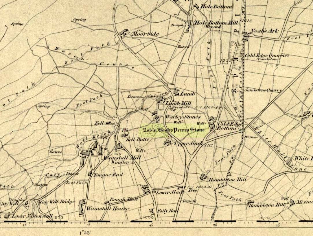
The Pennystone on 1852 map

All remains of this site, first mentioned as a stone circle in 1836, have gone. The place could be found by the appropriately named Stone Farm at the top end of Wainstalls and was first mentioned by John Watson (1775), who strangely said nothing about any circle here.  However, this changed when John Crabtree (1836) arrived and described a ring of stones surrounding a large boulder in the centre (illustrated here). The boulder itself was actually called the Robin Hood Penny Stone.

Folklore

Watson's 1775 drawing
Watson’s 1775 drawing

This was one of the many legendary sites from where our legendary outlaw practiced shooting his arrows.  He was also said to have picked up and thrown a large standing stone from this spot, until it landed three-and-a-half miles away on the hillside on the other side of the Calder Valley. (this was known as the Field House, or Sowerby Lad Standing Stone)

References:

  1. Bennett, Paul, The Old Stones of Elmet, Capall Bann 2001.
  2. Crabtree, John, Concise History of the Parish and Vicarage of Halifax, Hartley & Walker: Halifax 1836.
  3. Dobson, R.B. & Taylor, J., Rymes of Robyn Hood, Alan Sutton: Gloucester 1989.
  4. Faull, M.L. & Moorhouse, S.A., West Yorkshire: An Archaeological Guide (4 volumes), WYMCC: Wakefield 1981.
  5. Varley, Raymond, “A Stone-Axe Hammer, Robin Hood’s Penny Stone and Stone Circle at Wainstalls, Warley, near Halifax,” in Yorks. Arch. Journal 69, 1997.
  6. Watson, John, The History and Antiquities of the Parish of Halifax, T. Lowndes: London 1775.

© Paul Bennett, The Northern Antiquarian

Rocking Stone, Rishworth Moor, West Yorkshire

Legendary Rock:  OS Grid Reference – SD 990 150

Archaeology & History

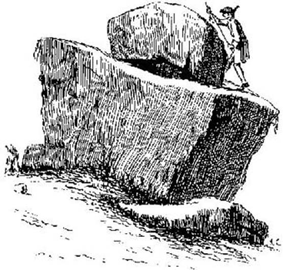
Rishworth Moor Rocking Stone, 1775

The reverend John Watson (1775) first wrote about this place, describing it as, “a group of stones, laid, seemingly, one above another, to the height of several yards, and called the Rocking stone.”  Very little archaeological remains have been described hereabouts, save the odd flint scatters here and there.  Anything which might have been here in the past was likely destroyed when the M62 was built right next to the site.

Folklore

The rocking stone was long ascribed in local tradition to be a  site used by the druids.  It was said that in bygone days the great boulder would rock, but this must have been a long time ago as even when Mr Watson described it, he told how “that quality is lost.”

Close by is the sometimes dried-up spring known as the Booth Dean Spa, which Watson thought might have been related to whatever ancient rituals occurred here.

References:

  1. Watson, John, The History and Antiquities of the Parish of Halifax, T.Lowndes: London 1775.

© Paul Bennett, The Northern Antiquarian

Wart Stone, Bradford, West Yorkshire

Standing Stone (destroyed):  OS Grid Reference – SE 15940 34211

Also known as:

  1. Ash Stone
  2. Pin Stone

Archaeology & History

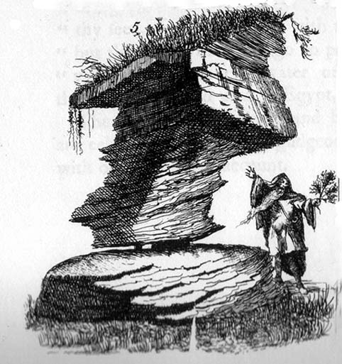
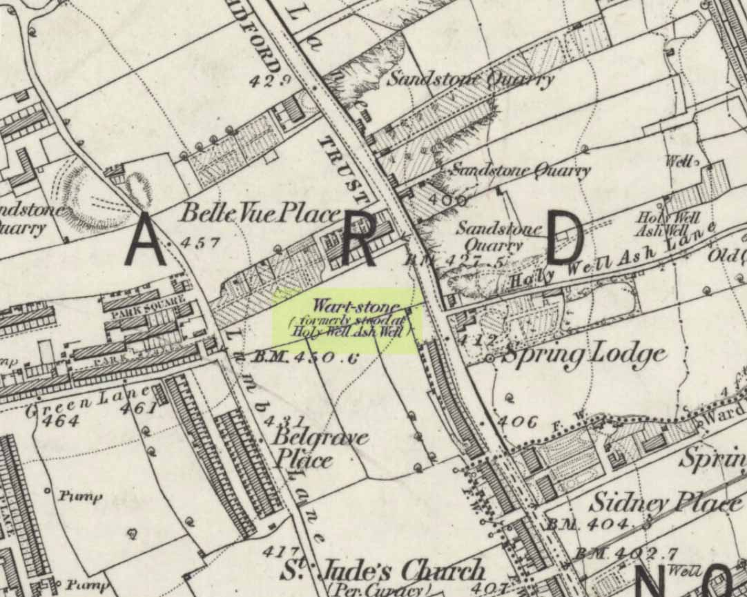
Wart Stone on 1852 OS-map

At Bradford City’s football ground there used to be the holy well known as the Holy Ash Well, adjacent to which was this old stone (as shown on the 1852 OS map).  For some reason it was uprooted and moved further up the hill around the end of the 19th century and was resurrected beside the old Belle Vue Hotel on Manningham Lane.  From thereon however, I’ve not been able to trace what happened to it, and presume it’s been destroyed.  It was known by local people to have had a ritual relationship with the adjacent healing well, to which people were said to visit from far and wide.

It seems to have been described first by Abraham Holroyd (1873), who told us that:

“In Manningham Lane there is a fine well, in old deeds called Hellywell, i.e., holy well, in a field now called Halliwell Ash, now a stone quarry… Near this is the ancient Pin Stone.”

The Bradford historian William Preston also made mention of the stone in one of his early surveys, where he told how local people also knew the stone as the Ash Stone, due to its proximity and ritual relationship to a great old tree.

Folklore

Also known as the Wart Stone, thanks to its ability to cure them and other skin afflictions.  Intriguingly, the building which now stands on the site is said to be haunted.

As my old school-mate, Dave Pendleton (1997), said of the place and its associated well:

“Prior to 1886 the only feature of any real note in the Valley Parade environs was a holy well that emerged near the corner of the football grounds Midland Road and Bradford End stands; hence the road Holywell Ash Lane. Today the site of the well is covered by the football pitch.

Only the road name survives as a reminder of what was apparently one of the district’s foremost attractions. On Sundays and holidays people would gather to take the waters and leave pins, coins, rags and food as offerings to the spirit that resided in the waters.

Accounts suggest that the well was covered and had a great ash tree standing over it (hence ‘holy ash’). There was also a standing stone called the wart stone of unknown antiquity. The stone had a carved depression that collected water. It was believed that the water was a miraculous cure for warts. Indeed, as early as 1638 the Holy Well had been credited with healing powers.

The well suffered a decline in popularity during the late nineteenth century and its keepers resorted to importing sulphur water from Harrogate, which they sold for a half penny per cup. The well disappeared under the Valley Parade pitch during the summer of 1886 and the wart stone was moved to the top of Holywell Ash Lane – which then ran straight up to Manningham Lane. The stone was still there as late as 1911 but thereafter it seems to have disappeared into the mists of time.”

Unfortunately we have no old photos or drawings of this lost standing stone – though I imagine that some local, somewhere must be able to help us out with this one.  Surely there’s summat hiding away…

References:

  1. Bennett, Paul, The Old Stones of Elmet, Capall Bann: Milverton 2001.
  2. Holroyd, Abraham, Collecteana Bradfordiana, Saltaire 1873.
  3. Pendleton, David & Dewhirst, John, Along the Midland Road, Bradford City AFC 1997.

© Paul Bennett, The Northern Antiquarian 

Ox-Foot Stone, South Lopham, Norfolk

Standing Stone (destroyed):  OS Grid Reference – TM 052 809

Folklore

This slab of sandstone apparently used to stand upright in one of the fields of Oxfootstone Farm and on its surface is supposed to be the burnt impression of a cow’s hoof-print. Legend tells that there was a fairy cow which would come into the area when times of hardship occurred. During such periods she would freely give her milk to the people, but when the drought was over she stamped down on the stone upon which she stood, burning the imprint of her hoof onto it and magically vanished back from whence she came. A variation of the tale tells of a normal cow whose milk normally supplied the local villagers. But one night a drunken man (in another tale it is a witch) milked the cow dry through a sieve, until only blood came from her udders. At this point, the cow cried out in pain and kicked the stone so hard that she left the mark of her hoof-print on it.

Another tale tells that an ox got a large thorn stuck in its foot and rampaged through the local village, eventually stamping its hoof onto the stone so hard that it left the imprint of its foot here.

Now this might sound presumptious of me — but this tale has all the hallmarks of it being an old folk-remnant telling the origin of some cup-and-ring marked stone.  We find a number of cup-and-rings with creation tales similar to this.  Are there any local archaeologists or enthusiasts in Norfolk who might be able to locate any remains of this possible carved stone?

References:

  1. Burgess, Michael W., The Standing Stones of Norfolk and Suffolk, ESNA 1: Lowestoft 1978.
  2. Dutt, W.A., The Ancient Mark-Stones of East Anglia, Flood & Sons: Lowestoft, 1926.

© Paul Bennett, The Northern Antiquarian