Wycoller Bridge, Trawden, Lancashire

Cup-Marked Stones:  OS Grid Reference – SD 931 393

Getting Here

Easy enough to find once you’ve actually got to Wycoller.  By car, the only real way to get here is from Colne, through the village of Winewall, and along the Wycoller road, which runs to a dead end.  Once here, the old packhorse bridge with these cup-marks on it can’t be missed!

Archaeology & History
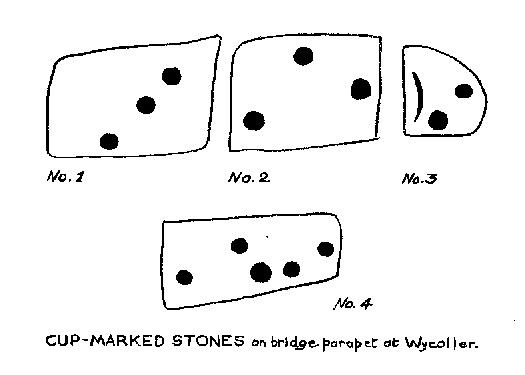
Wycoller Bridge's cup-marked stones (after Jackson, 1962)
Wycoller Bridge’s cup-marked stones (after Jackson, 1962)

Weird one this! On the famous packhorse bridge close to the old hall, four of the stones have cup-markings etched onto them. It seems that at least three of the carvings are archaic; cups on one of them seems somewhat deep and appears to be medieval. A short article describing them was in the Bradford Cartwright Hall Archaeology Bulletin (1962) where they were just as puzzled about them.  In 1979, J.A. Heginbottom described them in his survey on the prehistoric rock-art of upper Calderdale.  The stones on which the cups were carved may have been taken from a prehistoric tomb on the edge of the moor further up the valley from here.

Folklore

Just next to this bridge is another, much older one, known locally as the Clapper or Druid’s Bridge which perhaps has some bearing on the curious cup-markings.  Legend tells that this older construction was so called “because legend has it that it led to an amphitheatre where the druids held human sacrifices” – and the field just up from here (to the southwest) was known as the Dripping Stone Field.  Hmmmmm…..

References:

  1. Bentley, John, Portrait of Wycoller, Nelson Local History Society 1975.
  2. Heginbottom, J.A., The Prehistoric Rock Art of Upper Calderdale, unpublished report: 1979.
  3. Jackson, Sidney, ‘Cup-Marked Stones at Wycoller,’ in Cartwright Hall Archaeology Group Bulletin, October 1962.

© Paul Bennett, The Northern Antiquarian

Brink Ends Cairn, Dovestones Moor, Wycoller, Lancashire

Cairn:  OS Grid Reference – SD 96138 42296

Getting Here

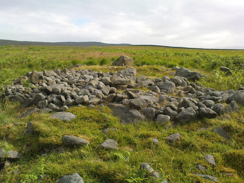
Best way to get up here is to start from the old hall and haunted bridge at Wycoller. From here walk upstream, on the footpath on the south side. It wibbles about following the waters for a half-mile until the moors open up when you reach an old stile, past which is another bridge over the stream. Walk past this (keep on the same side) for another 50 yards, then walk up the hillside where, if the vegetation is low, you can just see a decent-sized collection of rocks. This is the old cairn.

Archaeology & History

I don’t think the site is in the Lancashire archaeological register, but it’s described in John Bentley’s fine local history work, Portrait of Wycoller from 1975. He told that,

“a suspected Bronze Age burial mound at Brink Ends in Wycoller was excavated by Stanley Cookson in 1971 and 1972. Although no interment was discovered, the remains of a fire was found in the centre of the mound with half-burnt twigs and coal.”

Brink Ends Cairn, Wycoller

It’s not unlike some of the giant cairns on Ilkley Moor and elsewhere, though not as big, nor as high, being only about 22-24 feet across. Some of the stones have evidently been taken for use in the local walling, and the ‘cairn’ is in a pretty abject state. It’s a bittova odd spot to be honest. Not 100% sure what to make of it – though flints, arrowheads and similar implements have been found on the moors here close by. Bentley (1975) also told how “Stanley Cookson had strong suspicions that an Iron Age settlement existed in this area, but only time and further exploration will tell.” A sentiment I tend to agree with. And on our first and only visit here — during one helluvan awesome downpour all day — what seemed like an Iron Age hut circle was noted a few hundred yards to the south; though we got so saturated that day that we decided to turn for home soon after looking at this cairn.

Cookson and Hindle (1985) later described this site as a “middle Bronze Age burial cairn of 1400 to 900 BC, adding:

“The 34ft diameter inner circle was excavated during 1956-58 disclosing flints, a hearth with an abundance of charcoal, and four pieces of coal on a round, heavily burnt stone.”

More visits to these moors to check for other archaeological sites are needed in the near future to see what else might be on these unexplored moors.

References:

  1. Bentley, John, Portrait of Wycoller, Nelson Local History Society 1975.
  2. Cookson, Stanley & Hindle, Herbert, Wycoller Country Park, H.Hindle: Colne 1985.

© Paul Bennett, The Northern Antiquarian