Maypole (destroyed): OS Grid reference – SD 5161 9212
Archaeology & History
Long since gone, it’s existence was recorded by, amongst others, the Kendal historian Cornelius Nicholson. (1861) He described it in relation to one of the town crosses, that was removed due to it being “an obstruction in the street.” The maypole too, he said,
“was another incumbrance, but indispensable, according to the custom of our forefathers. It stood in Kirkland, opposite the house of the late Thomas Reveley, Esq., and was suffered to remain till within eighty years ago. In the time of our good Queen Katherine, who may fairly be supposed to have partaken of the amusements, countenanced by her royal consort, the original festivity of maying and morris-dancing would be here celebrated, by the annual ceremony of “maying” when, immediately after sunrise, on the 1st of May, processions, entering the town at various inlets, streamed through the streets, with music of horns and flutes; boys with their May-gads (willow-wands twined with cowslips), and girls with their “brats” full of flowers — young and old alike joining in merry laughter, and song, and the customary chorus, “We have brought the summer home.” When the above-named ceremonies became less fashionable, the May Pole was made the rendezvous of all the milkmaids in the neighbourhood, who came and paraded round it on Easter Mondays. On other occasions of rejoicing, afterwards, such for instance, as terminating an apprenticeship, and the like, it became customary for young men to go and dance around it.”
The author then told that this annual village ceremony was still being performed at the beginning of the 19th century, “in the assemblage of young people in the Vicar’s Fields, on Easter Tuesday. After spending the afternoon there, they returned in procession through the streets, threading grandy needles.”
References:
Nicholson, Cornelius, The Annals of Kendal, Whitaker & Co.: London 1861.
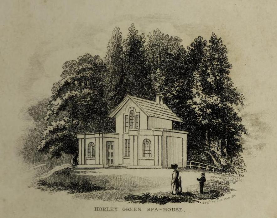
The historian William Addison (1951), in his history on the subject, told how “the spas began as holy wells”; and although no direct accounts are left of early dedications here, the remnants of Mayday traditions tell us there were more archaic goings-on before the waters were taken by the aristocrats. Once it had been designated as a spa, the waters were covered and a typical Spa House constructed over them. From hereon, for more than a century, the waters were accessible only to those with money who wished their ailments to be treated.
Between the end of the 18th to the end of the 19th century, the Horley Green Spa was a very prominent ingredient in the history of Calderdale. A chalybeate or iron-bearing spring, its waters were directed into a large underground cistern covered by metal. Thomas Garnett (1790) was the first to write about it, telling us:
“The Horley Green water is quite pellucid—sparkles when poured out of one glass into another—and has a sharp, aluminous, styptic taste, not unlike ink. The taste is not unpleasant when the water is taken from the springhead and drank immediately.”
He went on to espouse the waters to be good in healing bone and rheumatic diseases, giving many first-hand accounts from people in Yorkshire and beyond who used the waters here with apparent success, including one case of curing diabetes! Its reputation was later reinforced in a book by William Alexander (1840), who told us how,
“I unhesitatingly affirm that the Horley Green Spa possesses a very strong claim to be regarded as a powerful tonic and chalybeate.”
By the time those words were written, it had already gained a considerable reputation and many were those who’d received treatment.
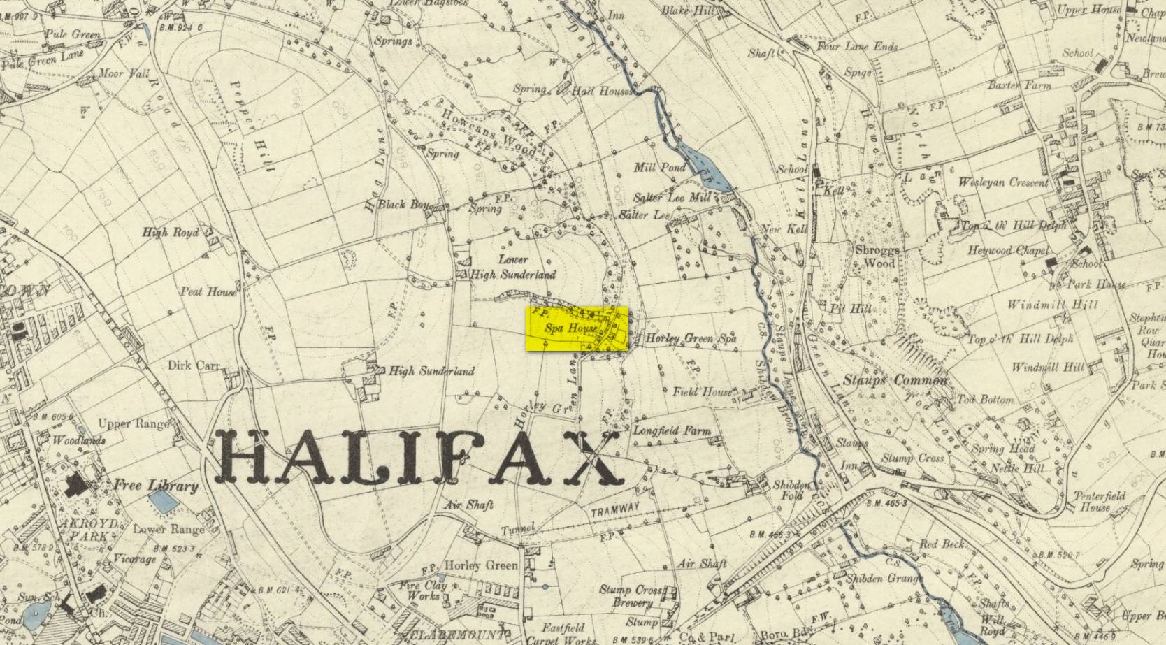
Spa House on 1894 map
A years after Alexander, the roving doctor A.B. Granville (1841) visited Horley Green—who described it as “a renowned steel-water Spa”. But at the same time he reported how its popularity had started to decline. But, via one Mr West, he did leave us with a greater chemical analysis of the Horley Green waters in an attempt, once more, to certify and prove its curative properties. Their results found the waters to possess, in varying quantities, lime, magnesia, silica, iron oxide, sulphur and silica—all of which further attributed the science of its medicinal actions. A number of case histories of the people cured here can be found in the works of Granville, Garnett and Alexander.
The well-house that stood here eventually fell into disuse. When it was eventually restored as someone’s home in the the late 20th century, the disused spring was found beneath the foundations, filled with stones.
Folklore
Horley Green’s spa well came about as a result of local people visiting the site around Beltane, probably for centuries before the aristocrats and early pharmacists took their hand to the place. But once the spa became renowned, people could only gather here “on the first Sundays in the month of May,” with Sunday being that legendary ‘day of the lord’ crap, to which the people would abide to save them from prosecution. It is obvious though that it had been used as a place of magick thanks to the snippets of lore which have found their way into local history books. We read how, at 6am, people gathered here, to such an extent that the roads were completely crowded. Those who arrived first were given bags of nuts: an archaic traditional motif found at many pre-christian wells in Britain. Occultists and ritual magickians amongst you will note the time when folk frequented the well, at 6am: the time when many nature-spirits are invoked for full effects. We find this time echoed in the ritual gatherings at Lady or St. Anne’s Well in Morley, just a few miles to the east.
References:
Addison, William, English Spas, Batsford: London 1951.
Alderson, Frederick, The Inland Resorts and Spas of Britain, David & Charles: Newton Abbot 1973.
Alexander, William, “On the Mineral Springs of the Parish of Halifax,” in Proceedings Geological & Polytechnic Society, West Riding, Yorkshire, volume 1, Edward Baines: Leeds 1849.
Crabtree, John, Concise History of the Parish and Vicarage of Halifax, Hartley & Walker: Halifax 1836.
Granville, A.B., Spas of England, Henry Colburn: London 1841.
Hembry, Phyllis, The English Spa 1560-1815, Athlone Press: London 1990.
Short, Thomas, The Natural, Experimental and Medicinal History of the Mineral Waters of Derbyshire, Lincolnshire and Yorkshire, privately printed: London 1724.
Short, Thomas, A General Treatise on Various Cold Mineral Waters in England, privately printed: London 1765.
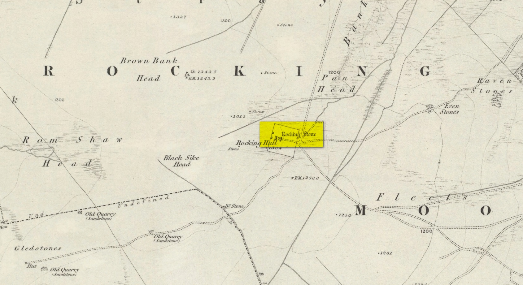
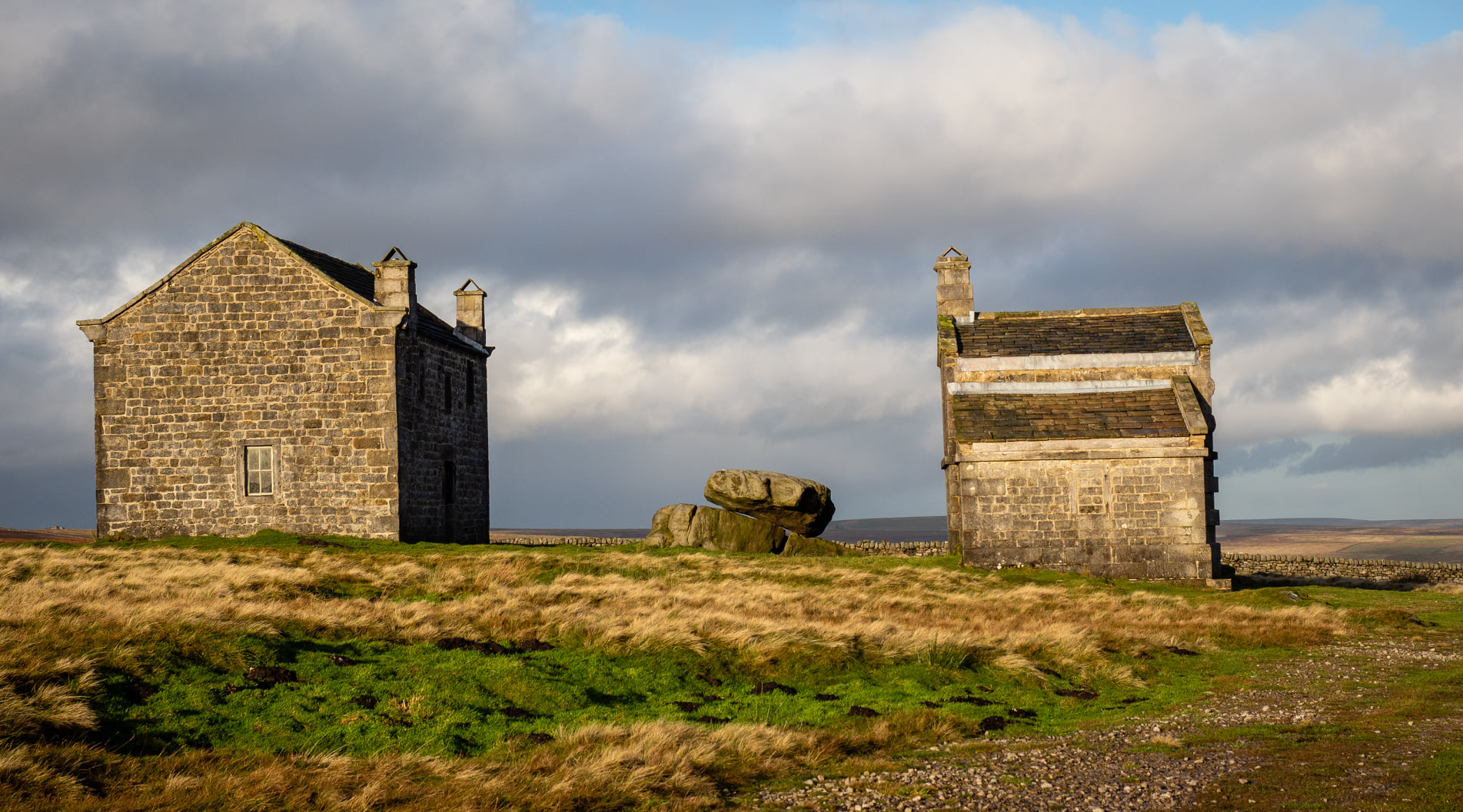
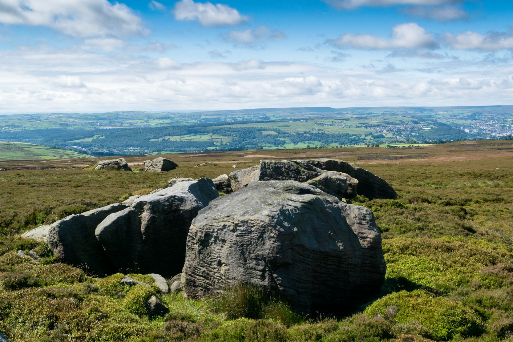
Visiting this site is a bittova walk across the moors, with probably the best route being along one of two footpaths from near the Outdoor Centre following (whichever is your preference) the moorland track or path westward onto the open landscape. Tis a 2½ mile walk before you reach two large buildings stuck high up in the middle of nowhere. Y’ can’t miss them. Equally unmissable is the large blatant rocking stone between the buildings. Gerron top of it!
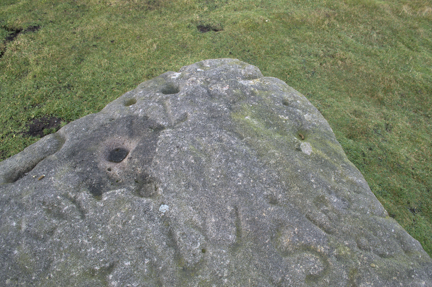
Archaeology & History
Rocking Stone, in situ
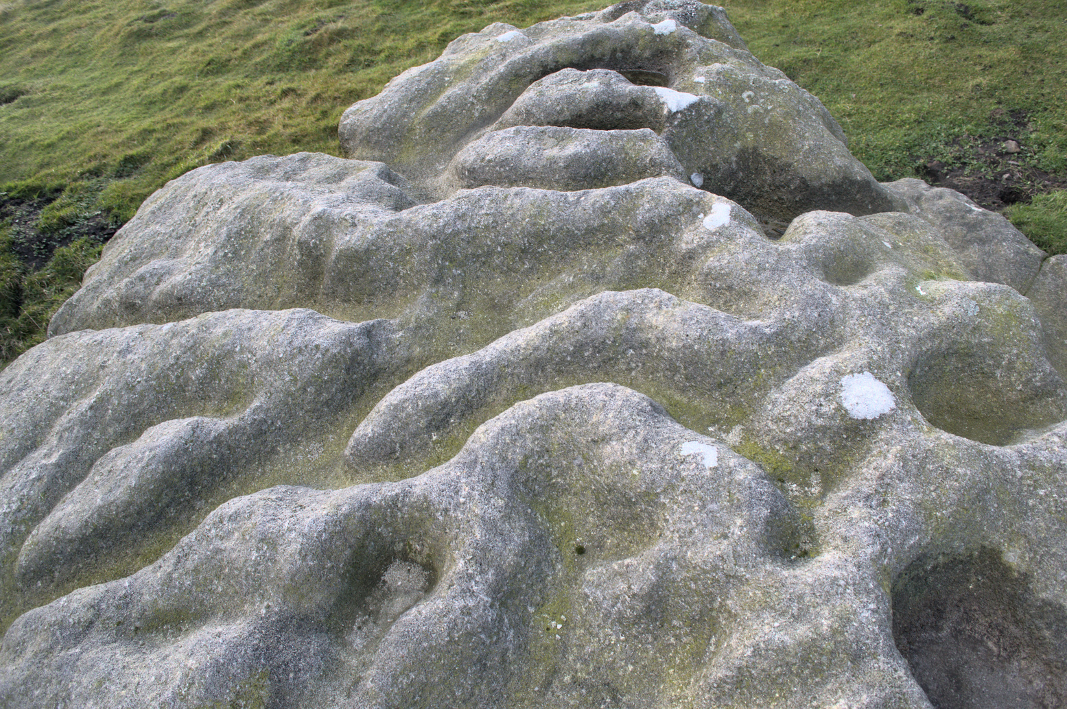
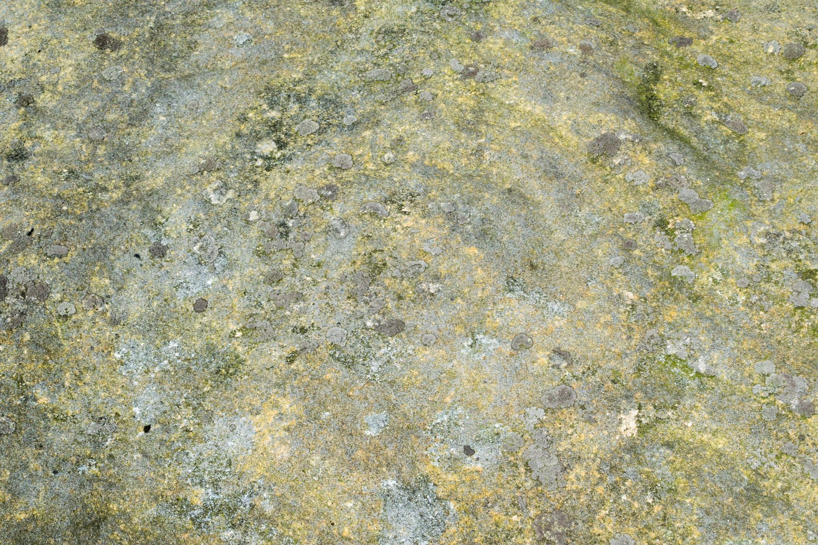
This impressive-looking rock that sits between the two buildings has a number of cup-markings of varying sizes across its topmost surface: some deep and some not-so-deep. There are perhaps as many as 20 of them on different parts of the stone, but some have been intruded on by more recent graffiti. On a recent visit to the site, photographer James Elkington and his young assistant MacKenzie, saw what looked like “a very faint ring around one of the cups” – which doesn’t surprise me. On one section of the stone we see a fascinating series of natural curves and geological undulations, some of which may have been modified a long time ago when the cupmarks were etched. But whether they were added to or not, it’s more than likely they’d have had some significance in the mythic nature of the rock.
The earliest description telling us that this possessed any prehistoric attributes seems to have been written by William Grainge (1871), in his huge work on the history of this region. He told that,
Faint ring highlightedSome of the many cups
“This rock…is eleven feet in length, seven feet six inches in breadth, and two feet six inches in thickness. The whole of the upper surface is thickly indented and grooved with cups and channels; the artificial character of which can be easily seen by anyone. This logan rests upon a lower rock, the upper surface of which is about three feet above the ground, fourteen feet in length, and nearly the same in breadth.”
Folklore
Curvaceous nature & cups
Although this yummy-looking geological sight no longer rocks, it wasn’t always that way. Indeed, according once more to the pen of Mr Grainge, although “it does not rock now, it has done so within living memory” – meaning that it would have been swaying at the beginning of the 19th century. We can only take his word for it. Also, as with many rocking stones the length and breadth of the land this, unsurprisingly it was adjudged to have been a place used by the druids.
References:
Grainge, William, The History and Topography of Harrogate and the Forest of Knaresborough, John Russell Smith: London 1871.
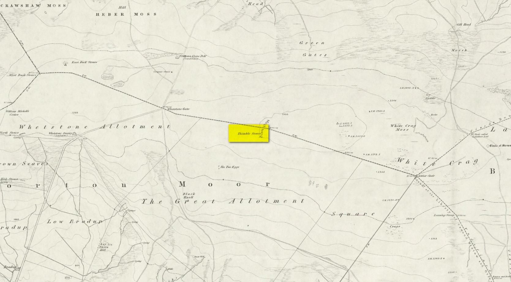
You can either head up to the Twelve Apostles stone circle, then a short distance west to the Ashlar Chair and head just head west along the moorland footpath that runs parallel with the old walling for ¾-mile (1.2km). This is the boggier route, beloved of real walkers! The other route is from the top of the Roman Road that bisects the moor at Whetstone Gate. From here, where the normal ‘road’ meets up with the dirt-track at the very top of the moors, take the footpath east for ½-mile (0.75km) until you reach the large cluster of rocks, just over the wall on your right-hand side. The carving is on top of one of them there stones.
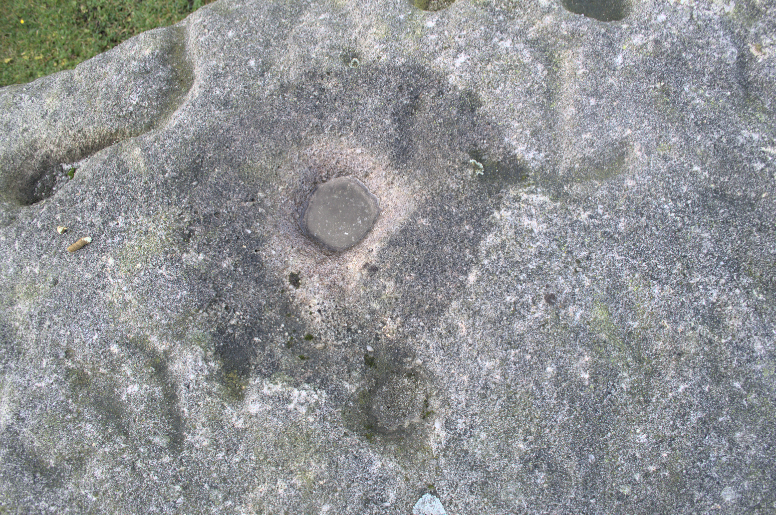
Archaeology & History
Without doubt there’s one helluva spirit to this cluster of large weather-worn rocks whose bodies gaze in every cardinal direction—and it’s a place where me and a number of earlier historians thought cup-and-rings could be found. The first petroglyphic context of the rocks was made in the 1860s by the grand 19th century historians Forrest & Grainge (2012) where they gave it the usual druidic associations, so beloved of academics and antiquarians alike at the time. They wrote:
Very faint cup-and-3-ringsThimble Stones gazing south
“The Thimble Stones are a ½-mile north of the Two Eggs, with which they are nearly in line. They are of the same outcrop of stratification and appear as though they had been pushed upwards by some force acting from beneath, breaking them up with a vertical fracture, and separating them so as to leave wide spaces between the blocks. They are about a furlong in length and in front about 10ft in height, diminishing eastward to the level of the ground. Two of them a few feet apart are 7ft high, and bear on their eastern angles the cups and channels which we designate the marks of Druidic consecration.”
Subsequently, in Collyer & Turner’s (1885) work they told that the rocks “bear cups on two margins”; and when the great Harry Speight (1900) came here, he found they were “bearing cups and grooves.” Yet no-one reported any rings. And in the countless visits I’ve made here—thinking that there must have been cup-and-rings!—no such symbols have ever cried out. The various large ‘bowls’ and lines that Nature has carved here—some of which may have been important in ancient days—are all that the casual eyes can see. Until now…
The local rambler and photographer James Elkington and James Turner were up here a couple of years ago. The light was falling through a clear bright sky and so, as James likes to do at such times, he clicked his camera a few times to catch the landscape. Clambering onto the rocks, Mr Turner unknowingly stood upon the carved rings, and when he moved his foot Mr Elkington spotted them! And as we can see on the image above, only just, there’s a single cup-mark surrounded by a concentric triple ring. Incredibly faint, it is without doubt the real McCoy—and the highest of all petroglyphs on these moors. In the photo it seems that there may be other elements to the carving, but until conditions allow for a further examination, we won’t know for sure.
James is hoping to get back up there when conditions are just right so he can get clearer photos. But if you hardcore antiquarians and petroglyph seekers wanna get up there y’selves to get some photos of your own, please send us whatever you might find.
Folklore
On the esoteric side, the Thimble Stones was a place favoured by the progenitors of the ritual magickal Order, the Illuminates of Thanateros, in years gone by.
References:
Allen, J. Romilly, ‘Cup and Ring Sculptures on Ilkley Moor,’ in Reliquary & Illustrated Archaeology, volume 2, 1896.
Bennett, Paul, The Old Stones of Elmet, Capall Bann: Milverton 2001.
Boughey, Keith & Vickerman, E.A., Prehistoric Rock Art of the West Riding, WYAS: Wakefield 2003.
Collyer, Robert & Turner, J. Horsfall, Ilkley, Ancient and Modern, William Walker: Otley 1885.
Feather, Stuart, “Mid-Wharfedale Cup-and-Ring Markings,” in Bradford Cartwright Hall Archaeology Group Bulletin, 6:3, 1961.
Forrest, Charles & Grainge, William, A Ramble on Rombald’s Moor, Northern Antiquarian: Bradford 2012 (1st published 1867-69).
Hedges, John (ed.), The Carved Rocks on Rombalds Moor, WYMCC: Wakefield 1986.
Speight, Harry, Upper Wharfedale, Elliott Stock: London 1900.
Acknowledgements: Huge thanks as always to James Elkington for use of his photos.
An entry in George Benson’s huge work on the history (mainly) of York, describes the holy well of St Dunstan “near the Glass Works”, which used to be at the south-side of the city on Fishergate. I can find no other reference to this site and it’s not on the early OS-maps, so we must presume it is long gone.
Other wells in his name can be found in Kent, Somerset, Sussex and Tottenham.
Folklore
The fable relating Dunstan to wells was his ability to make springs miraculously appear. Tradition relates him to have been born in Wessex in the 10th century. His festival date is May 19.
References:
Benson, George, An Account of the City and County of York – volume 3, Cooper & Swans: Micklegate 1925.
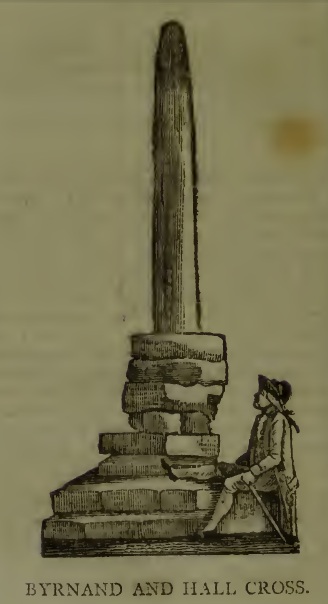
This long lost Cross could once be seen close to the Tudor era Byrnand Hall, which stood on the north side of the High Street. The Hall was demolished around 1780, and replaced by the present building, which is now a political club. The Cross was taken down around the same time, so we’re very fortunate to have a contemporary sketch.
Harry Speight (1906), the Great Yorkshire antiquarian, described the Cross when he was writing of the ‘big houses’ of Knaresborough, saying:
“Another notable old mansion was Byrnand Hall, which stood at the top of the High Street facing Gracious Street, and was rebuilt about a century ago. It was the property and seat for many generations of one of the leading families of Knaresborough, named Byrnand, one of its members being recorder of York in 1573. Opposite the house stood a very ancient stone cross, consisting of a plain upright column, without date or inscription, supported by several rudely-formed stones placed on three tiers or steps. It appears that one Richard Byrnand paid a fine and was permitted to enclose a cross standing on a piece of waste land then lately belonging to Robert Nessfield. The cross may be conjectured to have been either a memorial or boundary-stone. In those days ” it was not enough,” says the old antiquary, Hearne, ” to have the figure of the cross both on and in churches, chapels, and oratories, but it was put also in church-yards, and in every house, nay, many towns and villages were built in shape of it, and it was very common to fix it in the very streets and highways.
“This ancient relic, the site of which is now marked by a brass cross sunk in the causeway, was in after times called the Byrnand Hall Cross, from its proximity to the house of the same name. It stands on the road equidistant between York and Leeds, being eighteen miles from either place.”
At the end of the eighteenth century, E. Hargrove wrote:
“The (Byrnand) family mansion was situated at the end of the High-street, leading towards York. Near it formerly stood an ancient Cross, which being placed on the outside of the Rampart, and opposite to the entrance into the borough, seems to have been similar in situation, and probably may have been used for the same purpose, as that mentioned by Mr. Pennant, in his History of London, which stood without the city, opposite to Chester Inn; and here, according to the simplicity of the age, in the year 1294, and at other times, the magistrates sat to administer justice. Byrnand-Hall hath been lately rebuilt, by Mr. William Manby, who took down the remains of the old Cross, and left a cruciform stone in the pavement, which will mark the place to future times.”
Abbot J.I. Cummins, writing in the 1920s about the Catholic history of Knaresborough, told:
“Of the Byrnand Cross beyond the old town ditch the site is now marked in York Place by a brass cross let into the pavement for Christians to trample on.”
The Cross occupied an important position in the Knaresborough of old, at one of the highest points of the town by the junction of the modern High Street and Gracious Street, this latter being the road down the hill to the riverside and the troglodytic shrines of St Robert of Knaresborough and Our Lady.
Assuming the eighteenth century drawing is an accurate representation of the Cross, it does give the impression of considerable antiquity, and looks to have been 15-16 feet (4.75m.) high. From its appearance it looks like either a prehistoric monolith or an Anglo-Saxon ‘stapol‘ or column, and if it was the latter, it may have been erected to replace an earlier heathen wooden column or sacred tree following the replacement of the old beliefs by Christianity. If so, there may be no reason to deny Hargrove’s speculation that Byrnand Hall Cross once had a similar juridical function to the Chester Inn Cross in London.
References:
Bintley, Michael D.J., Trees in the Religions of Early Medieval England, Woodbridge, Suffolk, Boydell Press 2015.
Cummins, J.I., “Knaresborough,” in The Ampleforth Journal, Vol XXIV, No II, Spring 1929.
Hargrove, E., The History of the Castle, Town and Forest of Knaresborough, 5th Edition, Knaresborough 1790.
Speight, H., Nidderdale, from Nun Monkton to Whernside, London, Elliot Stock, 1906.
Standing Stone (lost): OS Grid Reference – SU 161 432
Archaeology & History
In William Stukeley’s Stonehenge, he described a number of monoliths outlying Salisbury Plain that also possessed a prehistoric pedigree. Most of them have been recorded, but this one seems to have been forgotten about — perhaps by virtue of it having fallen into the River Avon! Edgar Barclay (1895) described it in his fine survey, saying:
“In the bend of the river below the village, is a large submerged stone; only during drought is any portion of it visible above water; it can, however, in ordinary times, be dimly seen from the bank, which is of chalk, here very steep and overgrown. The country people assert that a metal ring, “turning always,” is let into its upper end. Legend relates that when the Devil brought the rocks of Stonehenge from Ireland, tied together with withes, this stone escaped from the bundle and fell into the river. Its position forbids the belief that it got fixed in the bed of the stream when its passage to Stonehenge was being attempted, for it lies immediately beneath the crest of a very steep bank, and at its most inaccessible point; as the stream sweeps against this, the water must always have been deep at this spot, the open valley would everywhere offer more favourable points for such an operation, especially would this be the case before the Avon was dyked. A boundary stone would have been placed on the brow of the hill; if the stone be a grey-wether, as report says, and as is probable, it may originally have stood on the bank, and “once upon a time”, a ring having been fixed in it, it may have been dragged into the stream to moor a ferry-boat. It lies closely midway between the stone on Bulford Down and that in Durrington fields.”
One wonders if any local people might know more about this…
References:
Barclay, Edgar, Stonehenge and its Earth-works, D. Nutt: London 1895.
Cross (destroyed): OS Grid reference – TA 0424 2064
Archaeology & History
This long lost wayside cross was described in various local records from 1621 upwards. In the definitive place-name survey of this area, Kenneth Cameron (1991) told us that this was,
“A medieval cross dedicated to St James, situated at the point where the Thornton and Burnham roads meet… Mr R. Newton comments, “said to have replaced a wayside shrine. The foundations of the shrine were exposed when the Home Guard dug a defensive trench there at the beginning of the last war. Foundations destroyed by a bomb.””
References:
Cameron, Kenneth, The Place-Names of Lincolnshire – volume 2, EPNS: Nottingham 1991.
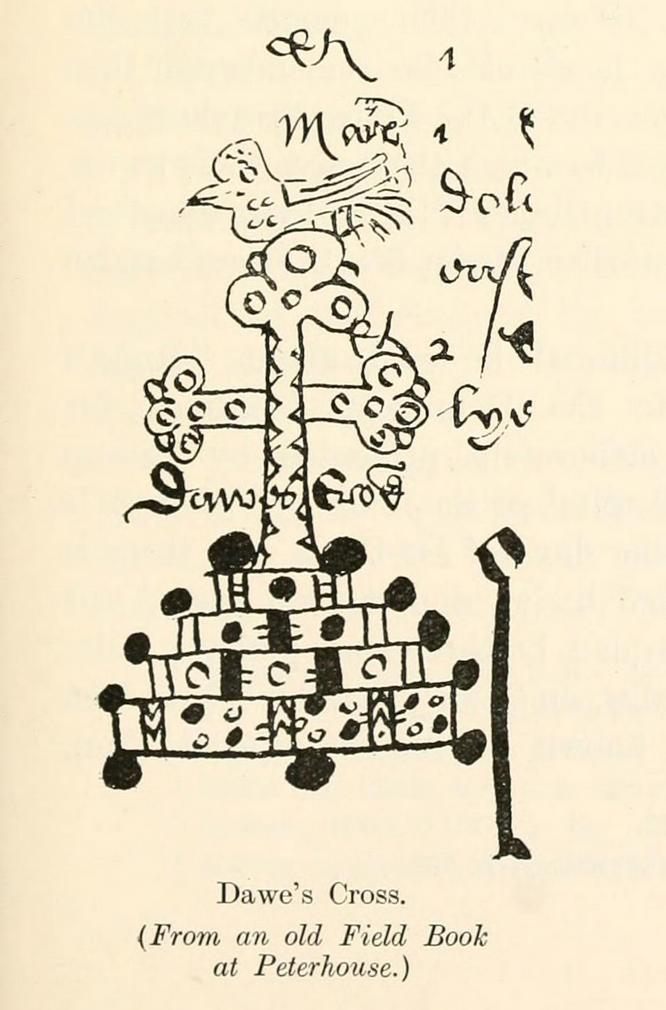
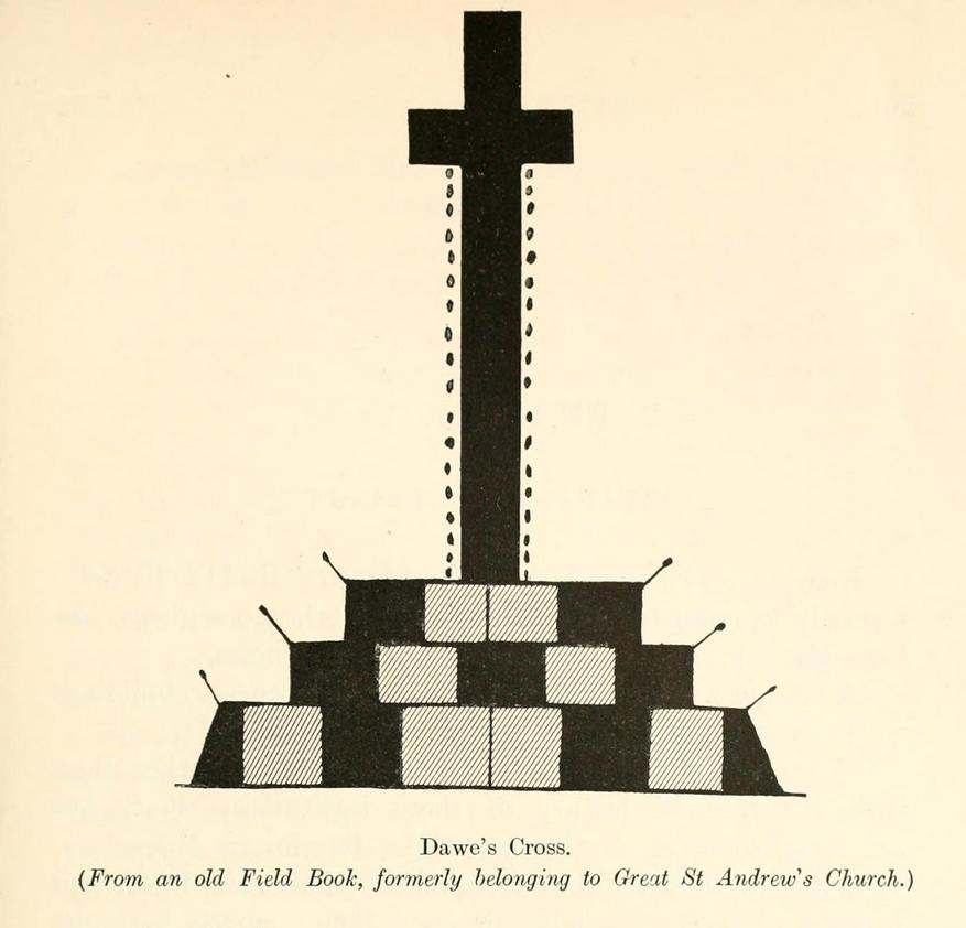
This is one of several medieval stone crosses in Cambridge that were destroyed several centuries ago. This particular one was erected on a three-stepped stone base at the old crossroads where, today, the modern A1307 of Regent Street meets the A603 Lensfield Road. It was described in an old Field Book of 1575 as standing being beside an old poplar tree, long gone. Mr H.P. Stokes (1915) gave us a short account of the site, telling:
“In describing the lane called “Deepway” between the London Road and the Hadstock Way and known as “King’s Lane” from the latter road to Hinton Way, mention was made of a Cross (called Dawe’s Cross) which stood at what is now known as Hyde Park Corner. Dawe’s Cross is often mentioned in ancient deeds, and in an old Field Book, which formerly belonged to the vestry of the Church of St Andrew the Great, there was a most interesting representation of it. This is here reproduced…from a copy in the celebrated Bowtell MSS.”
The cross stood along one of Alfred Watkins’ (1932) “archaic tracks”, or leys, in this area—although he wasn’t aware of its existence.
Tumuli (destroyed): OS Grid Reference – TL 6246 6048
Also Known as:
Two Howes
Archaeology & History
Mentioned as early as the 15th century in the Ely Cartulary as the “Tuomhowe,” or “two hills”, the place-name authority P.H. Reaney (1945) identifies this with the two “barrows” which our early cartographers map as our ‘Two Captains’.
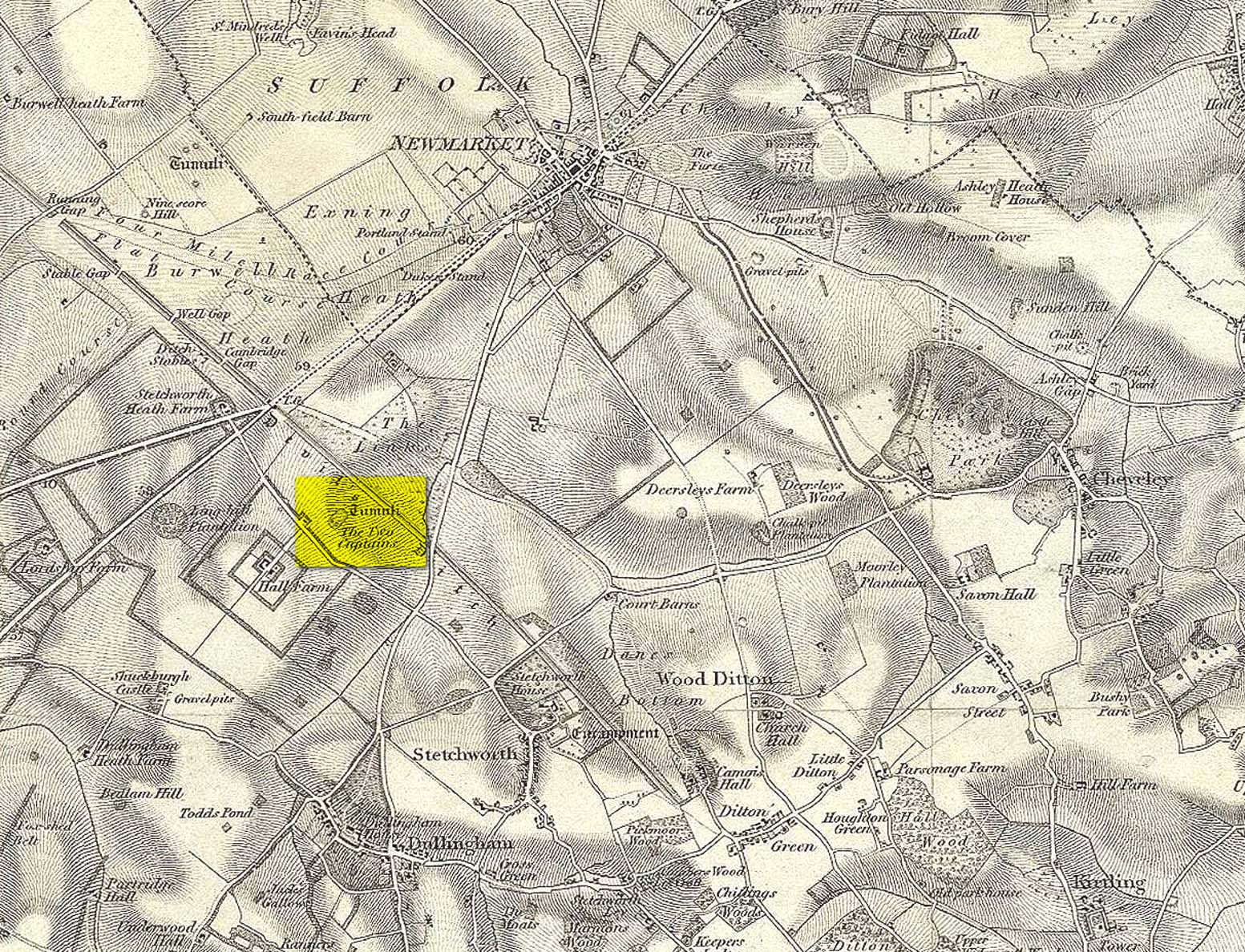
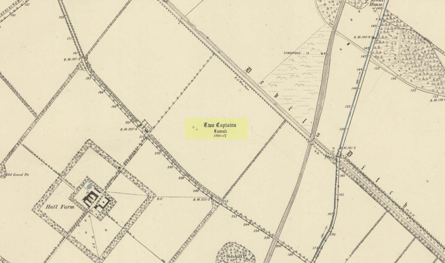
Site shown on 1834 mapSite of the Two Captains on the 1885 OS map
In the 1834 survey by the Ordnance Survey lads, these conspicuous burial mounds were clearly marked on the west side of the Devil’s Dyke, less than 2 miles south of the Newmarket Necropolis. They were seen first-hand by a number of local walkers, including A.J. King (1845) in his account of the aforementioned dyke. But on the 1885 OS map, the old tombs had apparently gone. Evidently some local knob-head had come along and took it upon himself to destroy these two burial mounds, which had lived here for thousands of years. However, despite the OS-maps indicating that it had been totally destroyed in the 1880s, a couple of later writers said that faint traces were still visible, including the historian Charles Harper. (1904) When he came here, he told how
“Little is now left of this once prominent mound, once important enough to be marked on Ordnance maps, but now ploughed nearly flat. It stands in the third field from the road, on the right hand, a field now under corn, but until forty years ago a wood.”
A.J. King’s 1845 map
Very little is known about the place and even the late great barrow fetishist, L.V. Grinsell (1936) could dig nothing out, despite the two tombs mentioned in passing by a number of writers.
Folklore
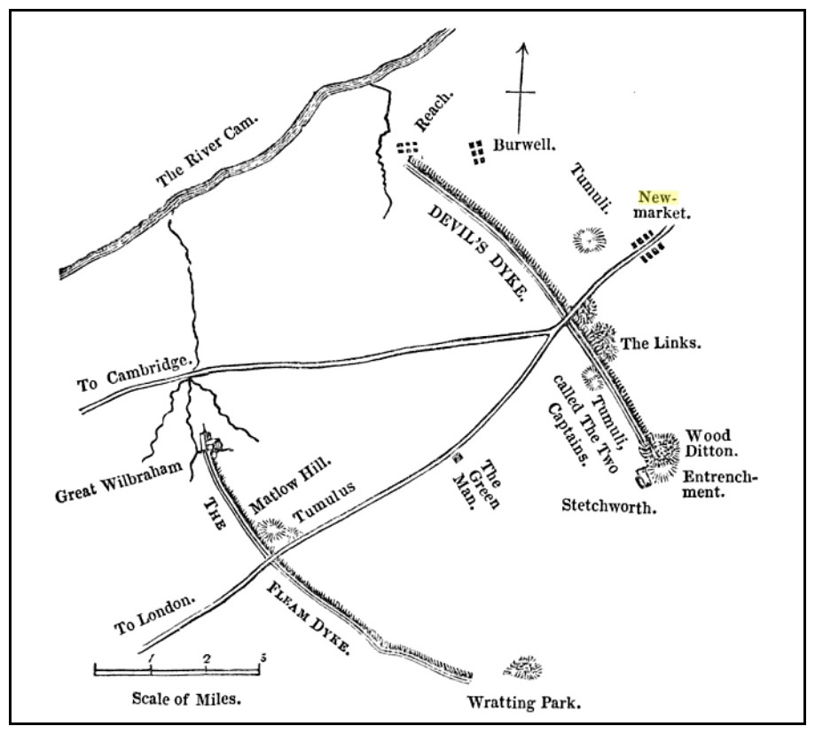
In Grinsell’s (1976) book on the folklore of ancient sites, he drops the Two Captains into a simple category of them relating to some battle, without any information. But it seems there isn’t much to go on. The local history work of Charles Harper (1904) intimates the same thing, bringing attention to the folklore of the adjacent Devil’s Dyke, as
“it is one of the many sites identified as the scene of Boadicea’s defeat by Suetonius Paulinus, but we are sceptical of this particular one, although the ancient tumulus on the outer face of the Ditch, still called the Two Captains, points to some forgotten conflict in which two leaders were slain and buried on the contested field.”
References:
Gomme, G.L., The Gentleman’s Library: Archaeology – volume 2, Elliot Stock: London 1886.
Grinsell, Leslie V., The Ancient Burial Mounds of England, Methuen: London 1936.
Grinsell, Leslie, Folklore of Prehistoric Sites in Britain, David & Charles: Newton Abbot 1976.
King, A.J., “The Devil’s Dyke, Newmarket,” in The Gentleman’s Magazine, January 1845.
Reaney, P.H., The Place-Names of Cambridgeshire and the Isle of Ely, Cambridge University Press 1943.
Royal Commission Ancient Historical Monuments, Inventory of Historical Monuments in the County of Cambridgeshire – Volume 2: North-East Cambridgeshire, HMSO: London 1972.
Tymms, S., “The Devil’s Dyke, Newmarket” in Proceedings Suffolk Inst. Archaeology. 1, 1849-53 168-70