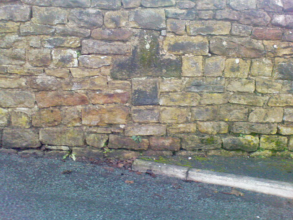
If you’re coming up to Oxenhope from Keighley, up the A6033 road, when you reach the school on the right-hand side of the road, a one-way street (Cross Lane) is where you need to walk down, for 200 yards, and keep your eyes peeled in the walling just before Cross Farm Court. Alternatively, via Haworth, go along Marsh Lane for a few hundred yards until your reach Moorhouse Lane on your left. Go down here for ⅓-mile (0.5km) and then go up Cross Lane on your right. About 120 yards up, in the walling just past the entrance into Cross Farm Court is where you’ll find it.
Archaeology & History
Very little seems to be known about the remains of this cross, embedded into the old walling. When it was described by Brigg & Villy (1914), they could find no information about it, and surmised that it marked the original track or road to Oxenhope from both Haworth and Halifax, “on the line of the old road by Withens.” Ostensibly it would seem to have been a wayside cross, marking old trackways (ley hunters take note!).
Visitors looking at it today can see that it’s barely noticeable. It looked no different even in Brigg & Villy’s days. It simply consists of only part of the original head of the cross, “the shaft having been broken off flush with the horizontal limb.” Some of the other stones that make up the bottom of this very poor-looking excuse of a cross were probably not part of the original, but were assembled into the wall to at least leave of memory of what it used to look like. It’s in a sorry state to be honest. A historic plaque should be placed here.
References:
Brigg, J.J. & Villy, F., “Three Ancient Crosses near Keighley,” in Bradford Antiquary, New Series 6, 1921.
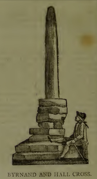
This long lost Cross could once be seen close to the Tudor era Byrnand Hall, which stood on the north side of the High Street. The Hall was demolished around 1780, and replaced by the present building, which is now a political club. The Cross was taken down around the same time, so we’re very fortunate to have a contemporary sketch.
Harry Speight (1906), the Great Yorkshire antiquarian, described the Cross when he was writing of the ‘big houses’ of Knaresborough, saying:
“Another notable old mansion was Byrnand Hall, which stood at the top of the High Street facing Gracious Street, and was rebuilt about a century ago. It was the property and seat for many generations of one of the leading families of Knaresborough, named Byrnand, one of its members being recorder of York in 1573. Opposite the house stood a very ancient stone cross, consisting of a plain upright column, without date or inscription, supported by several rudely-formed stones placed on three tiers or steps. It appears that one Richard Byrnand paid a fine and was permitted to enclose a cross standing on a piece of waste land then lately belonging to Robert Nessfield. The cross may be conjectured to have been either a memorial or boundary-stone. In those days ” it was not enough,” says the old antiquary, Hearne, ” to have the figure of the cross both on and in churches, chapels, and oratories, but it was put also in church-yards, and in every house, nay, many towns and villages were built in shape of it, and it was very common to fix it in the very streets and highways.
“This ancient relic, the site of which is now marked by a brass cross sunk in the causeway, was in after times called the Byrnand Hall Cross, from its proximity to the house of the same name. It stands on the road equidistant between York and Leeds, being eighteen miles from either place.”
At the end of the eighteenth century, E. Hargrove wrote:
“The (Byrnand) family mansion was situated at the end of the High-street, leading towards York. Near it formerly stood an ancient Cross, which being placed on the outside of the Rampart, and opposite to the entrance into the borough, seems to have been similar in situation, and probably may have been used for the same purpose, as that mentioned by Mr. Pennant, in his History of London, which stood without the city, opposite to Chester Inn; and here, according to the simplicity of the age, in the year 1294, and at other times, the magistrates sat to administer justice. Byrnand-Hall hath been lately rebuilt, by Mr. William Manby, who took down the remains of the old Cross, and left a cruciform stone in the pavement, which will mark the place to future times.”
Abbot J.I. Cummins, writing in the 1920s about the Catholic history of Knaresborough, told:
“Of the Byrnand Cross beyond the old town ditch the site is now marked in York Place by a brass cross let into the pavement for Christians to trample on.”
The Cross occupied an important position in the Knaresborough of old, at one of the highest points of the town by the junction of the modern High Street and Gracious Street, this latter being the road down the hill to the riverside and the troglodytic shrines of St Robert of Knaresborough and Our Lady.
Assuming the eighteenth century drawing is an accurate representation of the Cross, it does give the impression of considerable antiquity, and looks to have been 15-16 feet (4.75m.) high. From its appearance it looks like either a prehistoric monolith or an Anglo-Saxon ‘stapol‘ or column, and if it was the latter, it may have been erected to replace an earlier heathen wooden column or sacred tree following the replacement of the old beliefs by Christianity. If so, there may be no reason to deny Hargrove’s speculation that Byrnand Hall Cross once had a similar juridical function to the Chester Inn Cross in London.
References:
Bintley, Michael D.J., Trees in the Religions of Early Medieval England, Woodbridge, Suffolk, Boydell Press 2015.
Cummins, J.I., “Knaresborough,” in The Ampleforth Journal, Vol XXIV, No II, Spring 1929.
Hargrove, E., The History of the Castle, Town and Forest of Knaresborough, 5th Edition, Knaresborough 1790.
Speight, H., Nidderdale, from Nun Monkton to Whernside, London, Elliot Stock, 1906.
From Alloa head east along the A907 road and park up at Morrison’s supermarket a half-mile on. From here, keep walking along the same road, but make sure you go on the dirt-track running parallel with the main road, and which runs alongside the field in which this monument is clearly visible. Just make sure you only visit it when the crops aren’t growing (between September through to April is OK).
Archaeology & History
This is a highly impressive monument, but I for one doubt that it has a wholly christian origin… The fact that a stone circle was on the same ridge totally visible a couple of hundred yards away, and a cluster of Bronze Age cairns immediately west, adds to my doubt; along with the sheer size of this thing trying to grab attention to itself. You’ll have to visit it yourself and see what I mean.
The stone was first described in the Old Statistical Account of the area in 1795, and it told:
“About a mile east of the town, there is a large upright stone, 7 feet 4 inches above the surface of the ground. It is three feet broad, and thought to be very deep in the Earth. The old people used to speak of the figure of a man on horseback, which they had seen on it. If any thing of that kind, or letters (as it is said), have been formerly observed, they are now totally effaced.”
However, in a footnote to this entry, it was said that,
“when the adjacent farm was enclosing, upwards of 20 years ago, a ditch was made close to the stone, when many human bones were discovered; which proves that a battle or skirmish had some time or other taken place near that spot; and probably some man of eminence was buried hard by, as it was a common practice of the Picts on such occasions. There are two stones resembling this one, in the neighbouring parish of Alva, at no great distance from the church, but not close to one another. They are both near the foot of the Ochils.”
It seems most probable that this great cross-carved monolith had some relationship to our heathen mythic history—an idea which has been put forward by others historians in bygone times. In Daniel Wilson’s (1851) huge work, he told us:
“On ground about half a mile to the east of the town of Alloa, called the Hawkhill, is the large upright block of sandstone sculptured with a cross which is represented in the annexed engraving. It measures ten and a quarter feet in height, though little more than seven feet are now visible above ground. A similar cross is cut on both sides of the stone, as is not uncommon with such simple memorials. During the progress of agricultural operations in the immediate vicinity of this ancient cross, in the spring of 1829, Mr. Robert Bald, C.E., an intelligent Scottish antiquary, obtained permission from the Earl of Mar to make some excavations around when, at about nine feet north from the monumental stone, a rude cist was found, constructed of unhewn sandstone, measuring only three feet in length, and at each end of the cover, on the under side, a simple cross was cut. The lines which formed the crosses were not rudely executed, but straight and uniform, and evidently finished with care, though the slab itself was unusually rude and amorphous. The cist lay east and west and contained nothing but human bones greatly decayed. Drawings of the cross and a plan of the ground, executed by Mr. Bald, are in the possession of the Society of Antiquaries. Here we possess a singularly interesting example of the union of Christian and Pagan sepulchral rites: the cist laid east and west, according to the early christian custom, yet constructed of the old circumscribed dimensions, and of the rude but durable materials in use for ages before the had superseded the aboriginal Pagan creeds.”
Old drawing of the site (after Wilson 1851)Hawk Hill Cross, looking north
A few years later there was another account of this cross published in the Proceedings of the Society of Antiquaries, Scotland (1889), echoing much of what Wilson described, telling of the discoveries of many human remains found hereby. And when the Royal Commission (1933) account of the place was written after their inspection team visited the site in 1925, they told:
“This slab…is set up on a knoll about 200 yards south of the main roadway between Alloa and Clackmannan and about midway between the site of the (Hawk Hill) cairn…and that of the (Hawk Hill) stone circle… It is packed round the base with fairly large stones and stands with its broad faces east and west. A cross of Celtic form is incised on both sides, the incisions being about half an inch in depth. On the east face the shaft is made to spring directly from a base, without the intervention of a basic line. The design on the west face is similar, but the shaft here has been almost entirely obliterated by weathering. The slab is 8 feet in height, 2 feet 7½ inches in width at the base, and 9 inches in thickness.”
Notice that the more recent accounts don’t mention the horse carving: an intriguing element which was however mentioned in some early local history works of the place. Indeed, some postulate that this may have Pictish origins. They may be right. As local historian T.C. Gordon (1937), told,
“that the old people of the parish could remember seeing on the soft surface of the stone the figure of a man on horseback.”
Cross on the east faceCross on the west face
On the day I visited this stone I couldn’t make out any carved horse, but it seemed that something may once have been carved near the bottom the western face…perhaps… One writer also suggested that the nearby place-name of Gaberston may have related to this stone cross, with the word literally meaning ‘The Pillar Stone of Brath (Brude),’ which as Mr Gordon said, thus provides “the link between the stone and (the Pictish leader) Brude, and this link is strengthened when we remember that the burn that runs through Alloa is called ‘the Brathy Burn.’”
The possible Pictish motifs of a horseman were mentioned again in a letter from the local County Planning Officer to the Alloa County Clerk in 1971, along with a recommendation that the cross be removed and placed into a museum to prevent further weathering and erosion. Thankfully this suggestion was not followed through and the cross remains where it belongs: in its position in the landscape to beguile and intrigue us over its hidden commemorative past. Long may it remain upon its hill.
A very impressive site indeed…
Folklore
Thought locally to have played a part on an alignment or ley line with a little-known Druid Stone by the roadside in Alloa, the Hawk Hill cairn, and Hawk Hill stone circle to its east. The historian T.C. Gordon (1937) told that the cross marked the site where the Picts fought against the Saxons, saying:
“We know that Finguine, son of Deleroith, died in that battle in 711 AD, and maybe Brude too. A stone cross still marks the place at Hawkhill.”
References:
Gordon, T. Crouther, A Short History of Alloa, Alloa Advertiser 1937.
Lothian, James, Alloa and its Environs, Alloa Advertiser 1861.
Miller, Peter, “Notices of the Standing Stones of Alloa and Clackmanan,” in Proceedings of the Society of Antiquaries, Scotland, volume 23, 1889.
Royal Commission on the Ancient & Historical Monuments, Scotland, Inventory of Monuments and Constructions in the Counties of Fife, Kinross and Clackmannan, HMSO: Edinburgh 1933.
Wilson, Daniel, The Archaeology and Prehistoric Annals of Scotland, Sutherland & Knox: Edinburgh 1861.
Simple. The church in the centre of the village across from the T-junction with the A5 is where it’s at!
Archaeology & History
Cross-base with cup-marks (from Owen, 1886)
At Corwen churchyard we find a number of curious old stone relics — not least of which is this seemingly 12th century christian cross, more than seven-feet tall, on the west side of the church. Not only does this have a curious history in itself, but the base on which the cross stands has what may be at least seven cup-markings etched on it. These were first mentioned – I think – by Elias Owen in his Old Stone Crosses of the Vale of Clwyd, (1886) who wrote:
“The stone basement in which the (cross) shaft is placed is elliptical in form, with transverse and conjugate diameters measuring respectively 64 and 60 inches; it is 12 inches or so thick, is of a slaty nature and might have been procured in the neighbourhood… There are seven peculiar artificial depressions along the surface of the pedestal, strongly resembling the cup-markings which are found occasionally on the capstones of cromlechs, etc. They are irregularly arranged: on the north side there are three, almost in a line; and on other parts of the stone there are four of these marks. They differ somewhat from each other in size and shape, but they are for the most part circular, though one is more of an oblong than a circle. They vary also in depth, one being two-and-half inches deep, while the others are shallow. The largest is three inches in diameter; the others are not so broad.”
Owen makes note of a previous description of the Corwen “cross” by Thomas Pennant in 1784, where sounds as if this stone had a decidedly megalithic precursor. He told us:
“A most singular cross in the churchyard merits attention: the shaft is let into a flat stone, and that again is supported by four or five rude stones, as if the whole had been formed in imitation of, and in veneration of, the sacred Cromlech of very early times.”
Two other crosses are found at Corwen church – one of which has a decidely heathen legend attached to it. The Carreg y Big yn y Fach Rhewllyd monolith is also found here, in the porch wall. A few miles east of here we also find another cup-marked stone, shown on The Old-Fashioned Antiquarian website. Looks a good n’!
References:
Owen, Elias, Old Stone Crosses of the Vale of Clwyd and Neighbouring Parishes, Bernard Quaritch: London & Oswestry 1886.
Take the road from Masham into this lovely hamlet and, as you reach the staggered crossroads, you’ll see a small village green with a single tree at where the four roads meet. In the grass below the tree is this forgotten monument!
Archaeology & History
Fearby Cross remains
Found at the meeting point of five old lanes, little has been written about the old cross remnants here, which is barely a foot high and rests on its roughly circular stone base. It sits where five old tracks meet and is thought to be medieval in origin. Speculation alone pronounces the site to have been a place where local council proclamations occurred, and where funerals stopped and the dead were rested.
One intriguing piece of information narrated by Edmund Bogg (1906) that may have had some relevance to the siting of this old cross, told that between here and the hamlet of Healey a mile west,
“there were formerly circles of upright stones and other relics suggestive of druidical origin.”
Any historical information or folklore relating to these apparent megalithic remains needs to be uncovered!
References:
Bogg, Edmund, Richmondshire and the Vale of Mowbray, James Miles: Leeds 1906.
In September, 1928, the old ley-hunter Alfred Watkins was out on one of his many rambles when he “saw a tall stone almost buried in the bank at this crossroads,” appropriately known as Picts Cross, about a mile south of Sellack — so he called it the ‘Picts Cross Stone.’ He also said, “It was Pricker’s and Prick’s Cross in 18th century maps, and Pig’s Cross in the 1832 Ord. Map. Now ‘pig’ is the present Welsh word for “a peak, a point, a pike.””
And a lovely pointy old stone it looks in his old photo! The monolith is in the hedgerow along the old boundary line.
References:
Watkins, Alfred, The Old Standing Crosses of Herefordshire, Simpkin Marshall: London 1930.
From Keighley town centre, take the main road to Oakworth (B6143) and you’ll see it right by the main roadside, about a mile up on the left-hand side upon a small grassy area in Exley Head, just past the turning up to Wheathead.
Archaeology & History
The upright stone monolith, or cross, which would once have stood here has long since disappeared. All we are left with today is the large cross-base by the roadside: roughly squared, with a large hollow at the centre in which the upright stone cross originally stood erect! In the past, a number of archaeologists and historians have speculated that the Exley Head Cross dated from as early as the 9th up till the 15th century. We may never find out for certain, though it’s likely a post-Domesday medieval relic. It’s position at the roadside gives it the category of being a ‘Wayside Cross’ and it is likely one in a deliberate sequence that were placed along the ancient route from above Keighley, to Oakworth and over the border into Lancashire, near Wycoller and beyond.
Close-up of Exley Head Cross base
Quite why it was placed here is something we may never know: though it is close by an old crossroads and could have replaced an earlier heathen site, but I’ve found no records to indicate this. Its position in the landscape would also have been more impressive before the housing was here, previously giving a wide open view of the Aire Valley below. I’d be grateful for any more info on this site.
References:
Brigg, J.J. & Villy, F., “Three Ancient Crosses near Keighley,” in Bradford Antiquary, New Series 6, 1921.
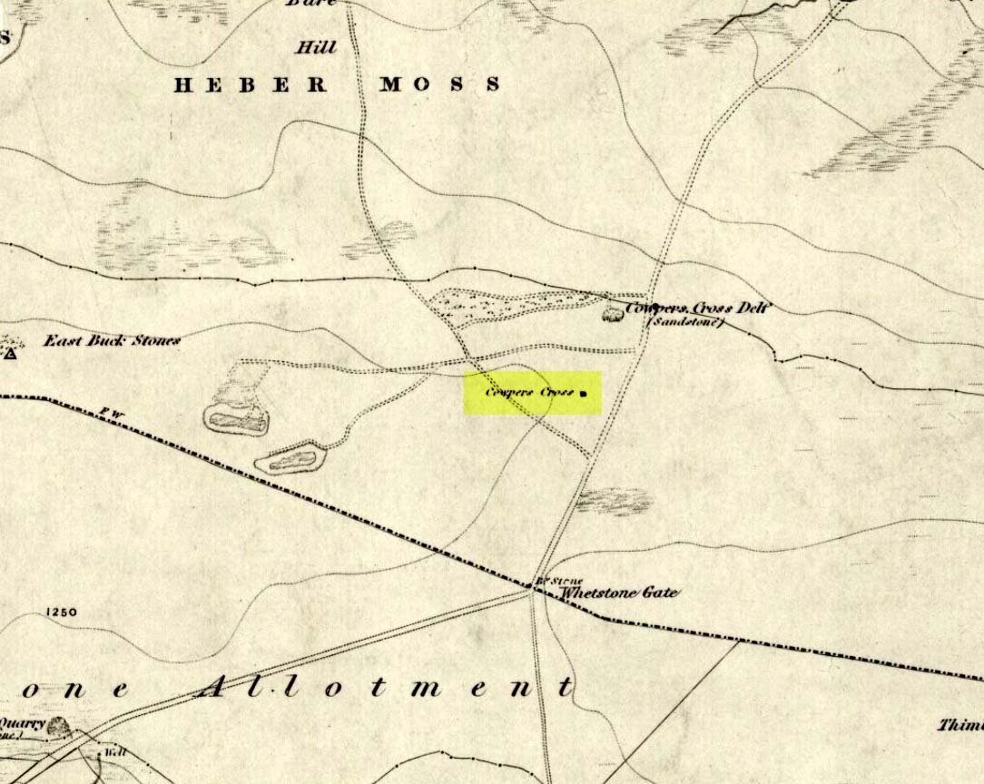
From Ilkley town, head up the road as if you’re going to White Wells but keep following the moorland road up towards Whetstone Gate and the TV masts on the very tops (you’ll have to walk the last half-mile). Shortly before you get them, you can’t miss this relic by the track-side on your right-hand side.
Archaeology & History
Possibly a christianised monolith, erected here in an attempt to divert local people away from the impressive Badger Stone where they may have held springtime gatherings. There used to be an old monolith laid on the ground a few yards away from the cross, which may have stood upright before the cross was erected. Also on the south-facing side of the cross were four cup-markings, indicating great age. These may also have been added when the cross was erected. (We know this occurred at other sites in the region, e.g., Churn Milk Joan, Midgley Moor, where such cup-marks were added sometime in the 15th or 16th century.) However, thanks to some idiotic halfwits in more recent years going up here and vandalizing Cowper’s Cross, the prehistoric cup-markings that were on this relic have been destroyed. The upright shaft of the cross that’s here now is a re-worked gatepost that replaced the old shaft with its authentic ‘pagan’ carvings.
1920s postcard of the Cross
But it’s had other bits of bad luck through the years. The site was struck by lightning many years back, splitting the stone in half, but has since been rebuilt and stands adjacent to its original position, right next to the old Roman road that crosses Ilkley Moor. Historian Allan Butterfield suggested this site to have originally been an old boundary markstone, christianised many centuries ago. The name ‘Cowper’ derives from the local Ilkley family of Cawper.
Those of you interested in the early christian history of these moors should also have a look at the little-known Black Knoll Cross, less than a mile south of here in the middle of Morton Moor.
Folklore
Folklore relates that markets were held at this old stone cross many years ago. This gives added weight to the idea that the nearby cup-and-ring marked Badger Stone, where markets were probably held around the time of the equinoxes, was the original site for such gatherings. Note that another site, the Reva Hill Cross, on the eastern side of this moor, has much the same history.
References:
Bennett, Paul, The Old Stones of Elmet, Capall Bann: Chieveley 2001.
Cowling, E.T., Rombald’s Way, William Walker: Otley 1946.
Not hard to locate. From Colne head up to Foulridge via the skipton Road and as you get to the middle of the town ask find the cenotaph just off the main road.
Archaeology & History
The Maiden or Tailor’s Cross, Foulridge
The Maiden or Tailor’s Cross has at least two old traditions attached to the site, which local historians think originate from the Civil War period. The first tells of a Royalist tailor who – sensibly – refused to make uniforms for Oliver Cromwell’s traitorous soldiers; but as a result, the poor tailor was shot by the troops and the remains of his body were placed over the old stone cross as a warning to his fellow workers. If you look closely on the cross you can see a crude carving of what looks like a pair of scissors or shears, and it is this carved symbol which has seemingly given birth to the legend of the tailor. There may, of course, be some truth in the story; but the carved shears is more likely an old Masonic carving – though quite who did it and when isn’t known.
The other legend is the one which apparently gave birth to the title of the Maiden’s Cross. It tells of a certain Margaret Burnard whose husband went into battle (on the side of the treacherous Cromwell), but who agreed before he set out that she should wait for him for to return by the side of the old cross; and this she did each and every day, waiting for her husband, Robert, to come back from the Civil War. But he was one of the many who died in the Battle of Marston Moor. However, Margaret refused to accept his death and returned to the cross each evening to their agreed meeting place. The story goes that Margaret herself herself was eventually killed by Royalist soldiers – and her body was buried at the cross where she had so often waited in vain.
It seems likely that this old cross originally replaced an old ‘heathen’ site in Foulridge. Several such spots were known here, though virtually nothing now remains. But notices of these sites will appear on TNA in the near future.
References:
Oldland, F., The Story of Foulridge, PHCL: Pendle 1990.

")


")