Dawe’s Cross, Cambridge, Cambridgeshire

Cross (destroyed):  OS Grid Reference – TL 455 578

Archaeology & History

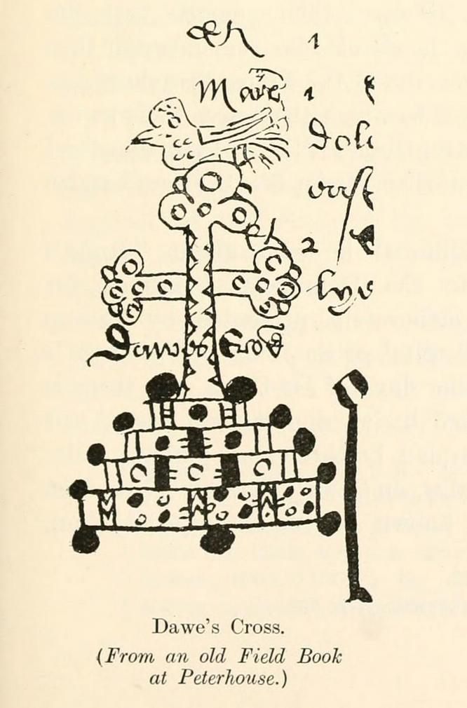
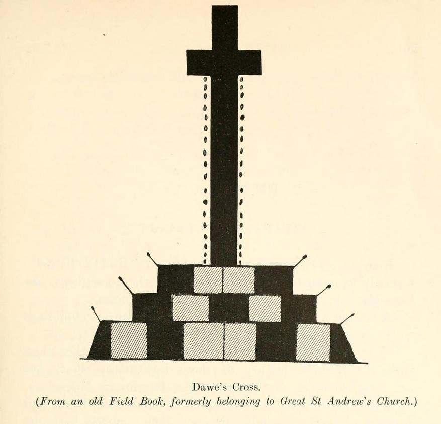
This is one of several medieval stone crosses in Cambridge that were destroyed several centuries ago.  This particular one was erected on a three-stepped stone base at the old crossroads where, today, the modern A1307 of Regent Street meets the A603 Lensfield Road.  It was described in an old Field Book of 1575 as standing being beside an old poplar tree, long gone.  Mr H.P. Stokes (1915) gave us a short account of the site, telling:

“In describing the lane called “Deepway” between the London Road and the Hadstock Way and known as “King’s Lane” from the latter road to Hinton Way, mention was made of a Cross (called Dawe’s Cross) which stood at what is now known as Hyde Park Corner.  Dawe’s Cross is often mentioned in ancient deeds, and in an old Field Book, which formerly belonged to the vestry of the Church of St Andrew the Great, there was a most interesting representation of it.  This is here reproduced…from a copy in the celebrated Bowtell MSS.”

The cross stood along one of Alfred Watkins’ (1932) “archaic tracks”, or leys, in this area—although he wasn’t aware of its existence.

References:

  1. Stokes, H.P., Outside the Barnwell Gate, Cambridge Antiquarian Society 1915.
  2. Watkins, Alfred, Archaic Tracks round Cambridge, Simpkin Marshall: London 1932.

© Paul BennettThe Northern Antiquarian

Maxey Cursus, Cambridgeshire

Cursus (destroyed):  OS Grid Reference – TF 125 078

Archaeology & History

Much of this site has unfortunately been completely destroyed.  Thought by Colin Burgess (2001) to be one of the earliest cursus monuments,  it was Paul Devereux (1989) who gave the clearest early description of this site,* telling:

“This site is to be found…between the village of Maxey and the River Welland, south of Market Deeping. When discovered by aerial photography the cursus was already partially destroyed… The northwest segment ‘starts’ almost on the banks of the Welland and goes southeast on a straight course to an obliterated point where a change of alignment occurred, and the cursus continues in a different direction. The total known length is 1930 yards (1.77km), and the width averages 190 feet (58 metres). The ditches themselves display subtly different orientations, but are in straight sections. The investigations of F. Pryor suggests that the northwest length of the cursus was constructed long after the southeast portion, when the latter’s ditches had become silted up (banks do not seem to have been present). The southernmost ditch of the southeastern section bisects two circular sites. Site A is particularly interesting. It occurs just east of the…change in direction, or junction of the two cursuses if such was the case.”

And such is the case, as recent discoveries have found. But before this was known for sure, Devereux wrote, that “a segment of cursus ditch emerges from this vaguely henge-like site, 450 feet in diameter, in the direction of the nearby church” of St. Peter.

The “henge-like site” described here has been defined by Oswald, Dyer and Barber (2001) as one of the enigmatic ’causewayed enclosure’ monuments – out of which emerges the other seperate alignment, the Etton Cursus, heading southeast.

References:

  1. Burgess, Colin, The Age of Stonehenge, Phoenix: London 2001.
  2. Loveday, Colin, Inscribed Across the Landscape, Tempus: Stroud 2006.
  3. Oswald, A., Dyer, C. & Barber, M., The Creation of Monuments, EH: Swindon 2001.
  4. Pennick, N. & Devereux. P., Lines on the Landscape, Hale: London 1989.
  5. Pryor, Francis, Britain BC, Harper-Collins: London 2003.

* The OS-reference for this site is of the northwestern end of the cursus. The southeastern terminal is at TF139063.

© Paul BennettThe Northern Antiquarian