Allington Hill, Bottisham, Cambridgeshire

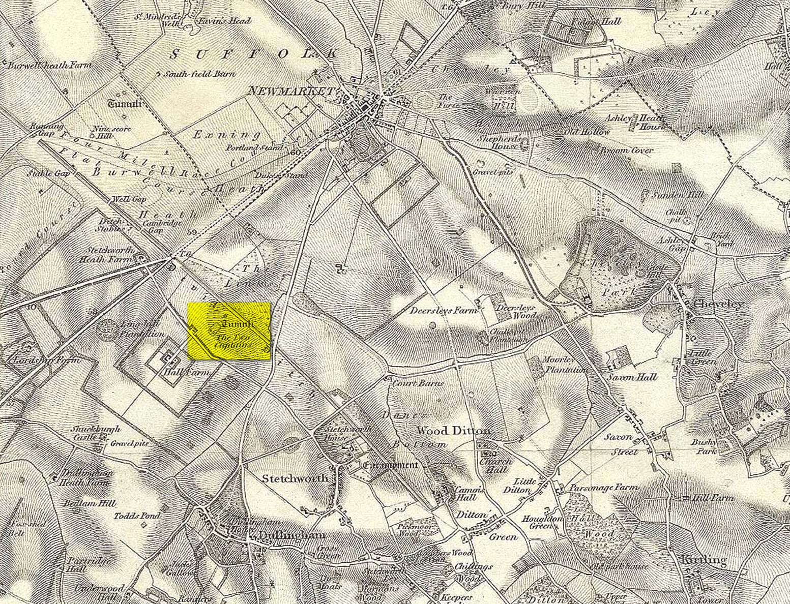
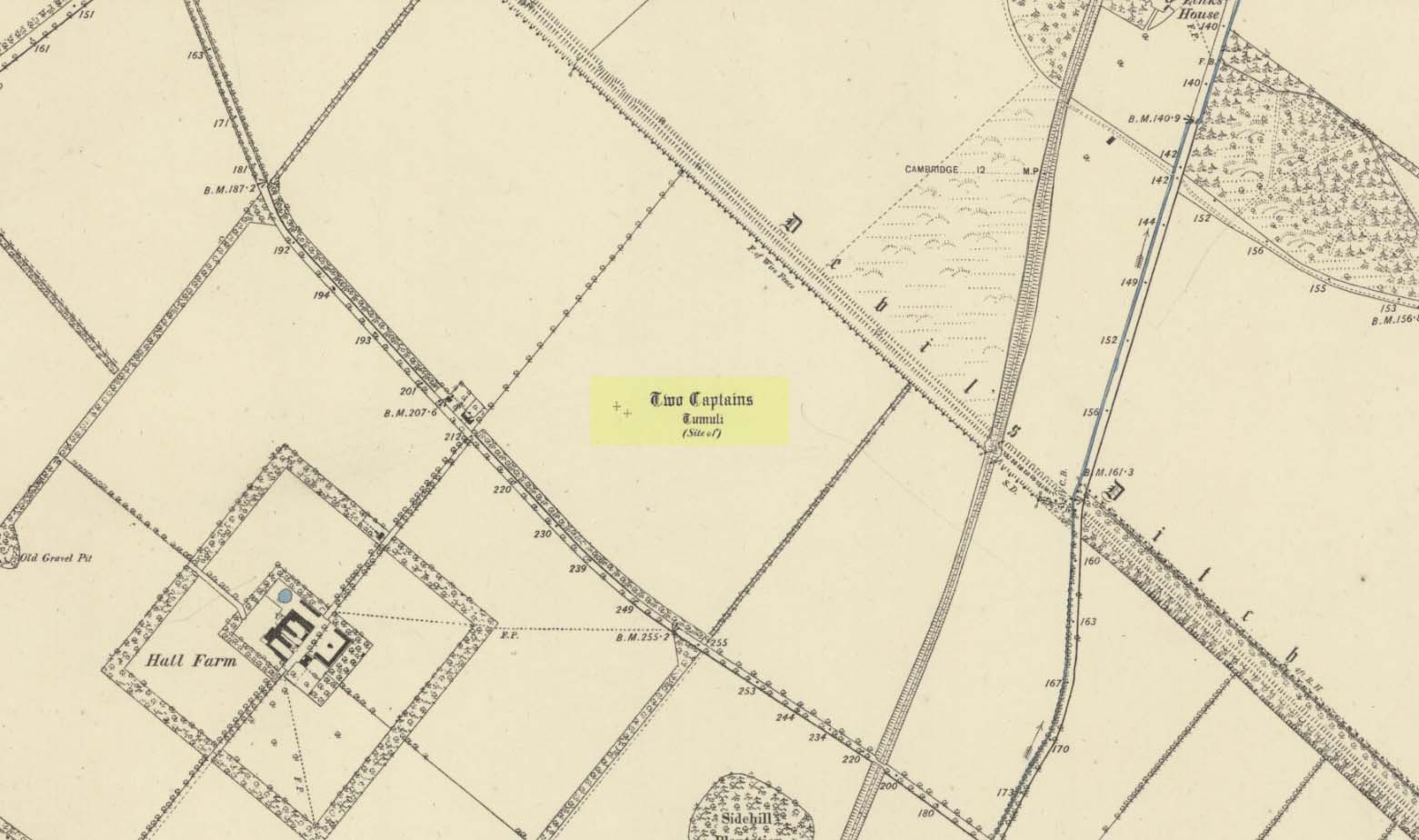
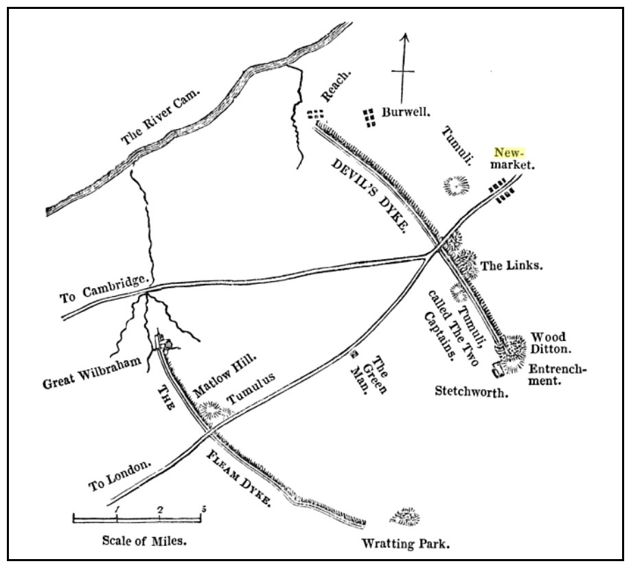
Tumulus (destroyed):  OS Grid Reference – TL 5801 5874

Archaeology & History

Site marked on 1886 map

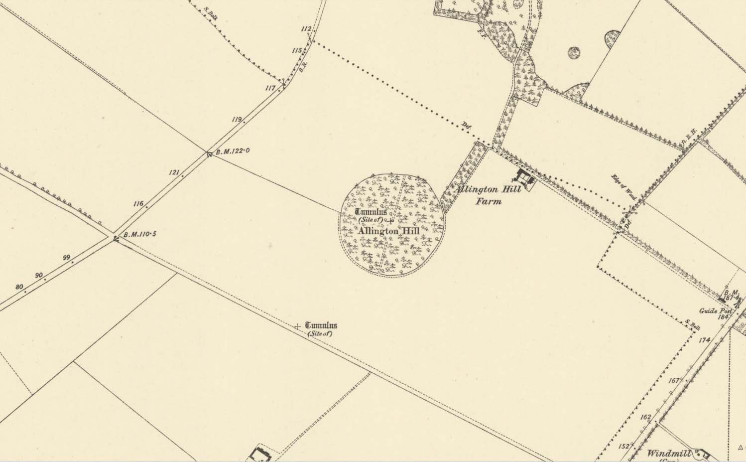
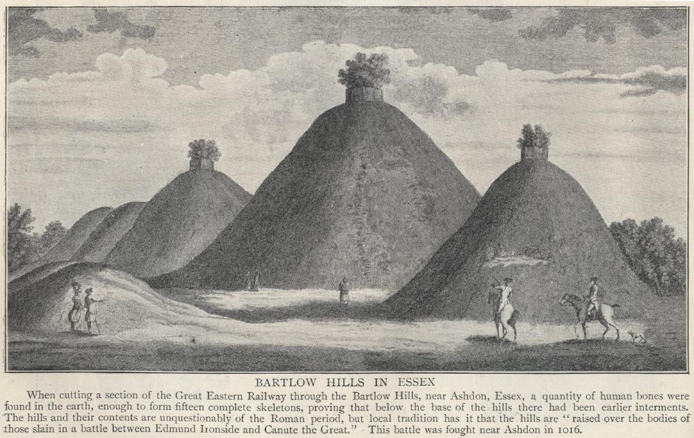
In times of olde on this prominent tree-covered hill, a tomb of some ancient ancestor once lived.  It had already been destroyed by some retards by the time the Ordnance Survey lads came here in 1885; but thankfully, memory gave its existence the note it deserved.  The place had thankfully been given the once-over by some archaeologists in the middle of that century, giving us a pretty good idea as to its size and nature.  Measuring some 90 feet across and fourteen feet high, this was no mere toddler!

A Mr W.T. Collings (1846) gave his Intelligence Report to the archaeological journal of the period, from which the following description is gained:

“The excavation of this tumulus in 1845 was made from east to west, commencing from the eastern side, in the direction of its centre, in which, at a depth of about three feet, there was found a cinerary urn in an inverted position, slightly tilted on one side, and surrounded by charcoal and burnt earth.  It was filled with charcoal, but contained only one small fragment of bone. This vessel, which was of the simplest manufacture, moulded by the hand, and sun-baked, measured in height five inches, and its diameter at the largest part was five inches and a half.  From the deep red colouring, and the general appearance of the surrounding soil, it would seem that a small hole had been first dug, charcoal and bones burnt in it, the vase placed on the fire in an inverted position, and the whole covered up.  About ten feet eastward of the central deposit, on the south side of the line of excavation, and half a foot deeper, a deposit of fragments of bone was found apparently calcined, but with little charcoal or burnt earth, forming a layer not more than three inches thick, and two feet in circumference.  There were several pieces of the skull, a portion of the alveolar process, inclosing a tooth, apparently that of a young person, pieces of the femur and clavicle, and other fragments.  A little to the north of this spot there appeared a mass of charcoal and burnt earth, containing nothing of interest. After digging five or six feet deeper, operations were discontinued; and on the next day shafts were excavated from the centre, so as completely to examine every part, without any further discovery, and in every direction charcoal was found mingled with the heap, not in patches, but in fragments.”

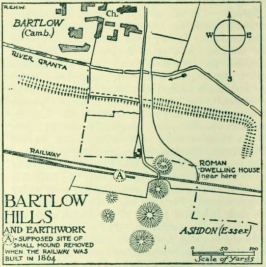
Collings reported the existence of another burial mound a short distance to the south.  It was one of at least five such tumuli in the immediate locale, all of which have been destroyed by retards in the area.

References:

  1. Collings, W.T., “Archaeological Intelligence,” in Archaeological Journal, volume 3, 1846.
  2. Hore, J.P., The History of Newmarket – volume 1, A.H. Baily: London 1886.
  3. Royal Commission Ancient Historical Monuments, Inventory of Historical Monuments in the County of Cambridgeshire – Volume 2: North-East Cambridgeshire, HMSO: London 1972.

© Paul BennettThe Northern Antiquarian

Beacon Hill, Swaffham Bulbeck, Cambridgeshire

Tumuli (destroyed):  OS Grid Reference – TL 584 600

Archaeology & History

The precise location of two prehistoric burial mounds at place with the conspicuous name of Beacon Hill, has yet to be satisfactorily located.  Their existence is recorded way back, in 1279 according to P.H. Reaney (1943), when they were described as Tweynhowes, being on the boundary of Swaffham Priory.  Information on them is scant and scattered with the earliest seeming to be an account by Thomas Kerrich (1817), who reported their removal and finds therein, in 1815.  The editor of Archaeologia told us:

Beacon Hill urn, 1817

“The Rev. Thomas Kerrich…exhibited to the Society, an Urn, which had been found a few days before by some labourers who were employed to remove one of the Barrows upon Newmarket-heath, called the Beacon Hills. “It stood upon what probably was the surface of the earth before the tumulus was raised.  The diameter of the barrow was near thirty yards, and the perpendicular height probably about eight or nine feet. There are more of these tumuli remaining, some of them very near to the place on which this, out of which the urn came, lately stood. They command an extensive view over the town of Cambridge, Gog-Magog Hills, &c.”

Subsequently a short piece in the Cambridge Chronicle in 1846 told the following:

“Two of the barrows on the edge of Newmarket Heath, belonging to the group called the Beacons, were examined in May 1846 by a party from Cambridge. In one of them nothing was found as it appeared to have been previously opened; in the other the remains of a British interment, consisting of rude vase (now in the Cambridge Antiquarian Museum), a few bones and some ashes, were discovered.”

This was echoed nearly forty years later in a survey by Charles Babbington (1883), who gave little by way of extra information; and was echoed again in Cyril Fox’s (1923) huge archaeological survey.  Herein, Mr Fox told us that the two barrows were located at the “east end of a four-mile racecourse.”  The only additional lore we’ve had since then is a collation of by the Royal Commission lads who thought that the respective tombs were located more precisely as the grid-references TL 5839 5998 and TL 5850 6004 respectively.

References:

  1. Cambridge Chronicle, May 23, 1846.
  2. Babbington, Charles C., Ancient Cambridgeshire, Cambridge Antiquarian Society 1883.
  3. Fox, Cyril, The Archaeology of the Cambridge Region, Cambridge University Press 1923.
  4. Hore, J.P., The History of Newmarket – volume 1, A.H. Baily: London 1886.
  5. Kerrich, Thomas, “An Urn found Under a Tumulus on Newmarket Heath,” Archaeologia, volume 18, 1817.
  6. Reaney, P.H., The Place-Names of Cambridgeshire and the Isle of Ely, Cambridge University Press 1943.
  7. Royal Commission Ancient Historical Monuments, Inventory of Historical Monuments in the County of Cambridgeshire – Volume 2: North-East Cambridgeshire, HMSO: London 1972.

© Paul BennettThe Northern Antiquarian

Dawe’s Cross, Cambridge, Cambridgeshire

Cross (destroyed):  OS Grid Reference – TL 455 578

Archaeology & History

This is one of several medieval stone crosses in Cambridge that were destroyed several centuries ago.  This particular one was erected on a three-stepped stone base at the old crossroads where, today, the modern A1307 of Regent Street meets the A603 Lensfield Road.  It was described in an old Field Book of 1575 as standing being beside an old poplar tree, long gone.  Mr H.P. Stokes (1915) gave us a short account of the site, telling:

“In describing the lane called “Deepway” between the London Road and the Hadstock Way and known as “King’s Lane” from the latter road to Hinton Way, mention was made of a Cross (called Dawe’s Cross) which stood at what is now known as Hyde Park Corner.  Dawe’s Cross is often mentioned in ancient deeds, and in an old Field Book, which formerly belonged to the vestry of the Church of St Andrew the Great, there was a most interesting representation of it.  This is here reproduced…from a copy in the celebrated Bowtell MSS.”

The cross stood along one of Alfred Watkins’ (1932) “archaic tracks”, or leys, in this area—although he wasn’t aware of its existence.

References:

  1. Stokes, H.P., Outside the Barnwell Gate, Cambridge Antiquarian Society 1915.
  2. Watkins, Alfred, Archaic Tracks round Cambridge, Simpkin Marshall: London 1932.

© Paul BennettThe Northern Antiquarian

Two Captains, Stetchworth, Cambridgeshire

Tumuli (destroyed):  OS Grid Reference – TL 6246 6048

Also Known as:

  1. Two Howes

Archaeology & History

Mentioned as early as the 15th century in the Ely Cartulary as the “Tuomhowe,” or “two hills”, the place-name authority P.H. Reaney (1945) identifies this with the two “barrows” which our early cartographers map as our ‘Two Captains’.

Site shown on 1834 map
Site of the Two Captains on the 1885 OS map

In the 1834 survey by the Ordnance Survey lads, these conspicuous burial mounds were clearly marked on the west side of the Devil’s Dyke, less than 2 miles south of the Newmarket Necropolis.  They were seen first-hand by a number of local walkers, including A.J. King (1845) in his account of the aforementioned dyke.  But on the 1885 OS map, the old tombs had apparently gone.  Evidently some local knob-head had come along and took it upon himself to destroy these two burial mounds, which had lived here for thousands of years.  However, despite the OS-maps indicating that it had been totally destroyed in the 1880s, a couple of later writers said that faint traces were still visible, including the historian Charles Harper. (1904)  When he came here, he told how

“Little is now left of this once prominent mound, once important enough to be marked on Ordnance maps, but now ploughed nearly flat.  It stands in the third field from the road, on the right hand, a field now under corn, but until forty years ago a wood.”

A.J. King’s 1845 map

Very little is known about the place and even the late great barrow fetishist, L.V. Grinsell (1936) could dig nothing out, despite the two tombs mentioned in passing by a number of writers.

Folklore

In Grinsell’s (1976) book on the folklore of ancient sites, he drops the Two Captains into a simple category of them relating to some battle, without any information.  But it seems there isn’t much to go on.  The local history work of Charles Harper (1904) intimates the same thing, bringing attention to the folklore of the adjacent Devil’s Dyke, as

“it is one of the many sites identified as the scene of Boadicea’s defeat by Suetonius Paulinus, but we are sceptical of this particular one, although the ancient tumulus on the outer face of the Ditch, still called the Two Captains, points to some forgotten conflict in which two leaders were slain and buried on the contested field.”


References:

  1. Gomme, G.L., The Gentleman’s Library: Archaeology – volume 2, Elliot Stock: London 1886.
  2. Grinsell, Leslie V., The Ancient Burial Mounds of England, Methuen: London 1936.
  3. Grinsell, Leslie, Folklore of Prehistoric Sites in Britain, David & Charles: Newton Abbot 1976.
  4. Harper, Charles G., The Newmarket, Bury, Thetford and Cromer Road, Chapman & Hall: London 1904.
  5. King, A.J., “The Devil’s Dyke, Newmarket,” in The Gentleman’s Magazine, January 1845.
  6. Reaney, P.H., The Place-Names of Cambridgeshire and the Isle of Ely, Cambridge University Press 1943.
  7. Royal Commission Ancient Historical Monuments, Inventory of Historical Monuments in the County of Cambridgeshire – Volume 2: North-East Cambridgeshire, HMSO: London 1972.
  8. Tymms, S., “The Devil’s Dyke, Newmarket” in Proceedings Suffolk Inst. Archaeology. 1, 1849-53 168-70

© Paul BennettThe Northern Antiquarian


Robin Hood & Little John, Castor, Cambridgeshire

‘Standing Stones’:  OS Grid Reference — TL 1395 9839

Also Known as:

  1. St. Edmund’s Stones

Archaeology & History

1885 OS-map of the site

1885 OS-map of the site

A curious and intriguing site with as many questions about its nature as there is its folklore.  Moved around by the conniving fuckwit politicians from Huntingdonshire, to Northants to Cambridge nowadays, one wonders where those fools will place it next!  Listed by a number of archaeologists as prehistoric standing stones, it seems pretty obvious from photos and the descriptions of many amateur students that—unless some original monoliths have been reworked a few centuries back—the narrative given by local historian W.H.B. Saunders (1888) outlines their more probable origin and history.  That’s not to say that the stones aren’t old—just not that olde…. Mr Saunders reasoned that they were dug and transported from more than 5 miles northwest of their present spot, telling that:

“Nothing can rob the stones of their undoubted antiquity.  The Barnack quarries have been exhausted for the last 600 years at least.  It is evident therefore, that the stones were placed in their present position at a time when the Barnack quarries were being worked.  That would be in the days of Robin Hood, and also when the Abbey of St. Edmund’s Bury, built of Barnack stone, was being erected.”

His words make sense when you look at the stature of the monoliths in question.  They’re cut and squared to the edges, with Robin Hood being the taller of the two stones, about 30 feet southwest of the Little John stone.  They have been written about quite extensively by historians down the centuries, from William Camden onwards.  One early account of the stones was written by Symon Gunton (1686) who told:

“I find in the charter of King Edward the confessor…that the abbot of Ramsey should give to the abbot and convent of Peterburgh 4000 eeles in the time of Lent, and in consideration thereof the abbot of Peterburgh should give to the abbot of Ramsey as much freestone from his pitts in Bernack, and as much ragstone from his pitts in Peterburgh as he should need.

“Nor did the abbot of Peterburgh from these pits furnish only that but other abbies also, as that of St. Edmunds-Bury: in memory whereof there are two long stones yet standing upon a balk in Castor-field, near unto Gunwade ferry; which erroneous tradition hath given out to be draughts of arrows from Alwalton church-yard thither; the one of Robin Hood, and the other of Little John; but the truth is, they were set up for witnesses, that the carriages of stone from Bernack to Gunwade-ferry, to be conveyed to S. Edmunds-Bury, might pass that way without paying toll; and in some old terriars they are called St. Edmund’s stones.  These stones are nicked in their tops after the manner of arrows, probably enough in memory of S. Edmund, who was shot to death with arrows by the Danes.  The balk they stand upon is still call’d St Edmund’s Balk.  They are supposed to be the petrify’d arrows of those two famous archers.”

Thom's sketch showing his midwinter alignment

Thom’s sketch showing his midwinter alignment

These traditions have subsequently been copied by all local historians.  So it is something of a curiosity to find our archaeologists—from Clarke (1960) and F.M. Pryor (1972) to Aubrey Burl (1993)—to cite these as prehistoric monoliths.  My suspicions as to their reasons relates to the folklore of the stones which are echoed at many truly prehistoric places like the Devil’s Arrows, etc.  The nature of the tale is an aboriginal creation myth, relating to the formation of sites as understood in animistic mythic structures.  But this archaeological misunderstanding brought the more scientific mathematical mind of Alexander Thom (1990:1) here in the 1980s where coincidence showed a common astronomical alignment.  Thom wrote:

“Clearly visible from the site, at an azimuth of 229°.22 is the lowest point of a low saddle on the horizon.  The col, Fig.1 (above), subtends an arc of about 0°.67 of azimuth, observed minimum altitude 0°.21.  For an estimated temperature of 44°F, correction for refraction at sunset is about 0°.54, and for solar and semi-diameter and parallax of respectively 0°.27 and 0°.002, the ‘observed’ declination is found to be -23°.92, which indicates a date of about 1860 BC.

“No presently obvious horizon marker was evident upon inspection of the open fields forming the horizon, but this does not mean that a foresight was never erected.  Without the evidence of a foresight it cannot be claimed that the two stones were placed for accurate calendrical reasons, but undoubtedly they indicate by themselves the winter solstice.”

The folklore may indicate the possibility that these two medieval standing stones replaced earlier ones, but no remains of such relics exist today.

References:

  1. Burl, Aubrey, From Carnac to Callanish, Yale University Press 1993.
  2. Clarke, R. Rainbird, East Anglia: Ancient Peoples and Places, Thames & Hudson: London 1960.
  3. Gover, J.E.B., Mawer, A. & Stenton, F.M., The Place-Names of Northamptonshire, Cambridge University Press 1975.
  4. Grinsell, Leslie V., Folklore of Prehistoric Sites in Britain, David & Charles: London 1976.
  5. Gunton, Symon, The History of the Church of Peterburgh, Richard Chiswell: London 1686.
  6. Mee, Arthur, Bedfordshire and Huntingdonshire, Hodder & Stoughton: London 1973.
  7. Morton, John, The Natural History of Northampton-shire; with Some Account of the Antiquities – 2 volumes, R. Knaplock: London 1712.
  8. Pryor, F.M., Prehistoric Man in the Nene Valley, Nene Valley Research: Peterborough 1972.
  9. Saunders, W.H.B., Legends and Traditions of Huntingdonshire, Simpkin Marshall: London 1888.
  10. Serjeantson, R.M. (ed.), The Victoria County History of Northamptonshire – volume 2, London 1906.
  11. Thom, Alexander, Thom, A.S. & Burl, Aubrey, Stone Rows and Standing Stones – volume 1, BAR: Oxford 1990.
  12. Thom, A.S., “A Solstitial Site near Peterborough,” in Journal of the History of Astronomy, 11, 1980.

© Paul Bennett, The Northern Antiquarian


Bartlow Hills, Bartlow, Cambridgeshire

Tumuli:  OS Grid Reference – TL 586 449

Also Known as:

  1. The Three Hills

Getting Here

1916 photo of Bartlow Hills

The best way to get here (when we went anyway, quite a few years back now), was via the old church . At the entrance to the church there was a signpost to the tumuli. Take the footpath to the left of the building and walk about 200 yards. Once you go under the railway bridge and into the trees, walk left and the overgrown mounds appear in front of you!

Archaeology & History

Thought to the largest Romano-British barrows in England, this was an incredible clump of giant burial mounds which, in more recent years, have been allowed to fall into neglect.  Although a railway was built through this clump, it bypassed the main tumuli—and in doing so uncovered another cemetery!  Four large barrows still remain and access, though alleged by some of those southern-types to be on private land, didn’t stop our foray here.  The usual “private” signs showing just how unwelcoming some of them are, just made us Northerners more determined to find ’em!  But that aside…

18th century drawing of the hills
1916 map & plan
1916 map & plan

Although nowadays classed as being in Cambridgeshire, when the Royal Commission lads visited the site and described it in their Inventory (1916), the mounds were in the parish of Ashdon on the northern edge of Essex. But now it comes under the parish of Bartlow in Cambridgeshire—which seem sensible, as the word ‘bartlow’ itself stems from these very monuments. As the regional place-name expert P.H. Reaney (1943) told, Bartlow means,

“‘(At) the mounds of the birch trees,’ OE (æt) beorca-hlãwum, (from the verb) beorc, hlaw, i.e., the great Bartlow Hills tumuli which dominate the church and village.”

Described as early as 1232 CE as Berkelawe, these hills were opened in the middle of the 19th century and found to possess a mass of Roman remains.  A number of articles in the journals of the period gave extensive descriptions of what was uncovered, but they are summed up nicely in the Essex Royal Commission (1916) report, which told:

“The principal monuments are the Bartlow Hills, which lie…at the extreme N.E. of the parish. They form (or formed) two parallel rows, running nearly N. and S.  The eastern row consists of four large steep-sided mounds, in shape truncated cones, the largest 40 ft. high and 145 ft. in diameter; since 1760 three of the mounds have been planted with trees.  The western row is now less clear: originally, it consisted of at least three small mounds, as was proved by digging in 1832; only two can now be faintly traced. Excavations, chiefly in 1832-40, have shown that all seven mounds contained at the centre regularly walled graves, within which was very costly grave-furniture of glass, decorated bronze, and enamel; almost all these ornaments were destroyed in a fire at Easton Lodge in 1847.  The graves seem to belong to the end of the first and beginning of the second century and were doubtless built for Romanized British nobles of the district. The particular method of burial occurs especially in eastern England and in Belgium, and is native, not Roman, by origin.

“…Other burials have been noticed near the Hills — one with a flint axe and knife, presumably prehistoric.  A small dwelling-house was found in 1852 about 100 yards E. of the Hills — mainly, if not wholly, within the Cambridgeshire border — but nothing of it is now visible on the surface.”

Section & sizes of the tumuli, 1916

The sites are very impressive indeed, though as we can see from the old images, when they were clear of trees they stood out much clearer.

Folklore

Old fairs used to be held at the Bartlow Hills, whose origin goes way back.  There is also a curious custom which probably originated in some way from traditional beating of the bounds of the local township boundaries, narrated by folklorist Enid Porter. (1969)  Throughout the region she reported how “skipping was performed on Good Friday”.  It commenced at 10am and would continue into the evening. Porter wrote:

“An eighty year old woman of Linton recalled in the 1930s that in her youth the villagers of Linton and Hadstock used to skip on Good Friday to Bartlow Hills to join in the fun of the fair held there.”

An early legend uncovered from archives by Leslie Grinsell told that here could be found a “treasure chest said to have been concealed by Oliver Cromwell in the barrows known as the Three Hills, or in pits near them.”

…to be continued…

References:

  1. Porter, Enid, Cambridgeshire Customs and Folklore, RKP: London 1969.
  2. Reaney, P.H., The Place-Names of Cambridgeshire and the Isle of Ely, Cambridge University Press 1943.
  3. Royal Commission on Historical Monuments, England, An Inventory into the Historical Monuments in Essex – volume 1, HMSO: London 1916.

© Paul Bennett, The Northern Antiquarian


Mutlow Hill, Great Wilbraham, Cambridge

Tumulus:  OS Grid Reference – TL 5466 5437

Archaeology & History

This once-impressive Bronze Age tomb is now much denuded and stands besides the legendary Fleam Dyke.  The name of Mutlow was first used to describe this site in the 1812 Enclosure Act and means, literally, an “Assembly Hill” or Assembly burial mound.  Reaney (1943) told that it was situated “at the junction of the boundaries of Great Wilbraham (Staine Hundred), West Wratting and Balsham (Radfield Hundred) and Fulbourn (Flendish Hundred)”, and was obviously an important moot spot where local tribal and council laws were made.

The great Cambridge archaeologist, Tom Lethbridge (1957) briefly described the place in his fascinating survey of the nearby hill-figures, Gog and Magog, saying:

“The hill itself is a Bronze Age barrow which was dug by the Hon. R.C. Neville about a hundred years ago.  In it were, amongst other things, glass beads brought to Britain from the eastern Mediterranean in the fifteenth century before the birth of Christ.  The barrow, which was presumably the site of a moot in Saxon times, seem to have been used as a sighting point for the construction of the Fleam Dyke… A circular Roman building, either a temple, or possible a signal station, stood close to Mutlow Hill.”

Lethbridge pointed out that another lesser-known trackway — “known in Saxon times as ‘the Street'” — also passed here, saying:

“When the land is ploughed and the light is right, you can see the numerous dark lines on the soil, all converging on Mutlow Hill.  These are the old hollow ways of the Icknield Way and the Street.”

Folklore

One legend here speaks of a golden chariot that is reputedly buried either inside, or near to the old tumulus.  Lethbridge (1957) again told of hearing this tale, though narrated, “it was said to be buried in Fleam Dyke near Mutlow Hill.”  When he asked a local lady about the tale,

“She replied that she had always heard that it was not in the dyke itself, but in the road which passed the dyke and went on to West Wratting and the southeast.”

References:

  1. Lethbridge, T.C., GogMagog: The Buried Gods, RKP: London 1957.
  2. Reaney, P.N., The Place-Names of Cambridgeshire and Isle of Ely, Cambridge University Press 1943.

© Paul Bennett, The Northern Antiquarian


Oliver Cromwell’s Hill, Eye, Cambridgeshire

Tumulus (destroyed):  OS Grid Reference – TF 232 018

Archaeology & History

Very little was known about this now lost burial mound.  It was one of several nearby but, thankfully, the local historian and archaeologist E. Thurnam Leeds (who once lived at the nearby Eyebury Farm) sent a letter to the Society of Antiquaries in London, describing some pottery and other remains that he’d found there:

“The small pot of a late Bronze Age type and the other sherds exhibited were found in a tumulus known as Oliver Cromwell’s Hill, at Eyebury, near Peterborough.  As only a portion of the tumulus has been examined as yet, it is proposed to defer a full account of the excavations until further progres has been made.  The tumulus is of the round type, about 40 yards in diameter and 5 feet high at the centre.  On three sides traces of a ditch were met with, containing soil which had evidently been burnt.  Close to the gravel in the centre of the tumulus there were two distinct layers of charcoal, and in two places apparently remains of hearths.  The small pot was found only 1½ feet down on the south-eastern side of the mound, 39 feet from the centre.  In the centre itself at various depths were found sherds, some of Bronze Age forms; but a pice of a rimmed vase found at a depth of 3 feet 6 inches, about 6 inches above the first charcoal layer, appears to be of Roman date, in which case the centre of the tumulus must have been disturbed in those times, though the charcoal floors were never pierced.  Bones of various animals, including sheep, pig, dog and hare, and a large flint flake were also found.”

As far as I’m aware, no further detailed examinations took place at this curiously-named hillock, whose folktale I’ve yet to read.

References:

  1. Leeds, E.T., ‘Letter,’ in Proceedings of the Society of Antiquaries, 22:1, 1910.

© Paul Bennett, The Northern Antiquarian


Maxey Cursus, Cambridgeshire

Cursus (destroyed):  OS Grid Reference – TF 125 078

Archaeology & History

Much of this site has unfortunately been completely destroyed.  Thought by Colin Burgess (2001) to be one of the earliest cursus monuments,  it was Paul Devereux (1989) who gave the clearest early description of this site,* telling:

“This site is to be found…between the village of Maxey and the River Welland, south of Market Deeping. When discovered by aerial photography the cursus was already partially destroyed… The northwest segment ‘starts’ almost on the banks of the Welland and goes southeast on a straight course to an obliterated point where a change of alignment occurred, and the cursus continues in a different direction. The total known length is 1930 yards (1.77km), and the width averages 190 feet (58 metres). The ditches themselves display subtly different orientations, but are in straight sections. The investigations of F. Pryor suggests that the northwest length of the cursus was constructed long after the southeast portion, when the latter’s ditches had become silted up (banks do not seem to have been present). The southernmost ditch of the southeastern section bisects two circular sites. Site A is particularly interesting. It occurs just east of the…change in direction, or junction of the two cursuses if such was the case.”

And such is the case, as recent discoveries have found. But before this was known for sure, Devereux wrote, that “a segment of cursus ditch emerges from this vaguely henge-like site, 450 feet in diameter, in the direction of the nearby church” of St. Peter.

The “henge-like site” described here has been defined by Oswald, Dyer and Barber (2001) as one of the enigmatic ’causewayed enclosure’ monuments – out of which emerges the other seperate alignment, the Etton Cursus, heading southeast.

References:

  1. Burgess, Colin, The Age of Stonehenge, Phoenix: London 2001.
  2. Loveday, Colin, Inscribed Across the Landscape, Tempus: Stroud 2006.
  3. Oswald, A., Dyer, C. & Barber, M., The Creation of Monuments, EH: Swindon 2001.
  4. Pennick, N. & Devereux. P., Lines on the Landscape, Hale: London 1989.
  5. Pryor, Francis, Britain BC, Harper-Collins: London 2003.

* The OS-reference for this site is of the northwestern end of the cursus. The southeastern terminal is at TF139063.

© Paul BennettThe Northern Antiquarian